Survey Number 8--SIDESCAN SONAR IMAGES, SURFICIAL GEOLOGIC INTERPRETATIONS, AND BATHYMETRY OF NEW HAVEN HARBOR, CONNECTICUT, AND THE NEW HAVEN DUMPING GROUND, NORTH-CENTRAL LONG ISLAND SOUND
Lawrence J.Poppe1, Ralph S.Lewis2, Harley J
Knebel.1, Eric A.Haase1,
Kenneth F. Parolski1, and Mary L. DiGiacomo-Cohen2
1
U.S. Geological Survey, Woods Hole, MA 02543
The U.S. Geological Survey has produced detailed geologic maps of the sea floor in Long Island Sound, a major U.S. east-coast estuary surrounded by the most densely populated region of the United States. These studies build upon cooperative research with the State of Connecticut that was initiated in 1982. During the initial phase of this cooperative program, geologic framework studies in Long Island Sound were completed (Lewis and Needell, 1987; Needell and others, 1987; Lewis and Stone, 1991). The second and current phase of the program emphasizes studies of sediment distributions, processes that control these distributions, nearshore environmental concerns, and the relationship of benthic community structures to the sea floor geology.
Anthropogenic wastes, toxic chemicals, and changes in land use patterns from residential, commercial, and recreational development have stressed the environment of the Sound causing degradation and potential loss of benthic habitats (Kopplemann and others, 1976; Long Island Sound Study, 1994). Detailed maps of the sea floor are needed to help evaluate the extent of adverse impacts and manage resources wisely in the future. Therefore, in a continuing effort to better understand Long Island Sound, we have constructed sidescan sonar mosaics (complete-coverage acoustic images) within specific areas of special interest (fig. 1). The mosaics presented here cover New Haven Harbor, Connecticut's major port, and the New Haven Dumping Ground, the most active disposal site in Long Island Sound. The mosaics and their interpretations: (1) define the geological variability of the sea floor, one of the primary controls of benthic habitat diversity; (2) improve our understanding of the processes that control the distribution and transport of bottom sediments, benthic habitats, and associated infaunal community structures; and (3) provide a detailed framework for future research, monitoring, and management activities. The sidescan mosaics also serve as base maps for subsequent sedimentological, geochemical and biological observations because precise information on environmental setting is important to the selection of sampling sites and to the accurate interpretation of point measurements.
Long Island Sound is about 182 km long by a maximum of 32 km wide. It is bordered on the north by the rocky shoreline of Connecticut, on the east by Block Island Sound, on the south by the eroding sandy bluffs of Long Island, and on the west by the East River and the New York metropolitan area. The Sound is an estuary; a place where saltwater from the ocean mixes with fresh water drained from the land. Because of their unique physical and chemical oceanography, estuaries are among the most highly productive environments in the world (Long Island Sound Study, 1994).
The New Haven Harbor study area (fig. 1), which covers about 27.4 km2 along the central Connecticut shoreline, falls largely within the harbor, but extends offshore covering most of the area between Morgan and Oyster River Points. New Haven Harbor is not only Connecticut's largest commercial port facility, but is also part of a thriving shellfish industry. The shellfish, primarily farmed eastern oysters (Crassostrea virginica) and hard clams or quahogs (Mercenaria mercenaria), thrive under conditions that include: a stable shallow-water habitat, appropriate nutrient availability, suitable salinities, and favorable tidal current patterns (John Volk, 1997, Connecticut Department of Agriculture, written communication).
Much of the northern part of the New Haven Harbor study area lies within a seaward extension of the Central Lowland of Connecticut and, therefore, is presumably underlain by Mesozoic rocks. The principle onshore equivalent of these rocks, the New Haven Arkose (Upper Triassic, possibly Lower Jurassic at the top), is composed of red, pink, and gray, coarse-grained, locally conglomeratic, poorly sorted sandstone interbedded with layers of reddish micaceous siltstone (Flint, 1965; Rodgers, 1985). The Light House Gneiss, a pink or gray to red, medium grained, generally well foliated granitic gneiss(Proterozoic), underlies most of the land south of Morris Cove and crops out near Lighthouse and Morgan Points. The Eastern Boundary Fault, which separates the New haven Arkose from the Light House Gneiss, continues west-southwestward across the southern part of Morris Cove and under the central part of this study area. The gray to silver, medium to fine grained, well layered to laminated rocks of the Oronoque Schist (Lower Ordovician?) underlie the western part of the study area. These rocks crop out at Bradley and Oyster River Points (Rodgers, 1985). Three valleys incised in the bedrock, which are seaward extensions of the West, Quinnipiac, and Farm River Valleys, coalesce under the inner harbor to form a single linear valley that extends toward the west-southwest (Sanders, 1965; Cambell and others, 1974).
The bedrock across much of southeastern Connecticut is unconformably overlain by two tills, one of pre-Wisconsinan age and one of late Wisconsinan age (Schafer and Hartshorn, 1965; Flint and Gebert, 1976; Stone and Schafer, 1992). The younger till forms a thin (2-5 m), discontinuous mantle over nearly all of the higher land around New Haven Harbor. This till is exposed onshore near the southwestern part of the study area around Oyster River Point, near the southeastern part of the study area around Lighthouse and Morgan Points, and along the northeast shore of Morris Cove (Stone and others, 1992). The till, whch is typically loose to compact and sandy and stony with large subrounded boulders, resembles the bedrock that immediately underlies it and possesses a distinct southwest fabric. Although both till sheets have been identified in the adjacent Branford and Mount Carmel Quadrangles (Flint, 1965), the older till has not been found around New Haven Harbor. Although the northward retreat of the late Wisconsinan ice sheet is marked in southeastern Connecticut by a northward succession of minor recessional moraines (i.e. the Hammonasset-Ledyard, Old Saybrook, and Mystic Moraines) no end moraines have been identified along the shores of New Haven Harbor (Flint, 1965; Goldsmith, 1982).
Stratified drift, deposited by glacial streams as outwash facies, blankets the tills and bedrock over most of West Haven and New Haven as part of the New Haven valley train, around Morris Creek east of Morris Cove as part of the Farm River valley train (Flint, 1965; Stone and others, 1992), and fills the river valleys incised into the bedrock (Sanders, 1965). Offshore from New haven Harbor, deltaic and varved lake deposits of glacial Lake Connecticut variously overlie the bedrock and glacial drift(Lewis and Stone, 1991; Stone and others, 1992). This lake, which occupied most of the Long Island Sound basin, was formed when the last ice front began to recede from the Harbor Hill-Roanoke Point Moraine position and meltwater was impounded in the expanding, long, narrow basin between the moraine and the retreating ice to the north (Stone and Borns, 1986).
The glacial drift and glaciolacustrine deposits are truncated by an unconformity. This unconformity is a composite product of the subaerial exposure, which occurred after glacial Lake Connecticut drained, and of the marine transgression that occurred after 15 ka (Lewis and Stone, 1991). A marine facies, which occurs in quiet-water areas throughout the Long Island Sound basin, overlies these earlier deposits and records deposition during the postglacial Holocene eustatic rise of sea level.
Salt marsh deposits, which consist of seaward thickening wedges of peaty mud and muddy peat, occur along Morris Creek, and Cove, West, and Quinnipiac Rivers. Although previously larger, some of the marshes have been filled during city redevelopment activity. Much of the present shoreline within New Haven Harbor, especially in New Haven and East Haven north of Morris Cove, is composed of sediment and man-made materials that have been artificially emplaced (Flint, 1965). Freshwater contributions from rivers discharging into New Haven Harbor are minor relative to the total tidal flux of water in and out of the harbor (Richards, 1988).
The New Haven Dumping Ground study area, which is located about 10.4 km south-southeast of Morgan Point and encompasses the Central Long Island Sound Disposal Site, covers about 15.9 km2 in north-central Long Island Sound. This area and three other open-water sites within Long Island Sound (Eatons Neck, Bridgeport, and New London) have historically received the vast majority of the spoils dredged from the borders of the Sound. For example, during 1954 and 1956 more than 4 million m3 were disposed of at the New Haven site (Schubel and others, 1979). The New Haven Dumping Ground continues to be one of the most active containment sites in New England because of its proximity to major commercial and recreational port facilities that minimizes disposal costs (Boyd and others, 1972) and because it is thought to be located in a depositional area of Long Island Sound, characterized by relatively weak bottom current regimes and subject to only shallow, wind-driven waves (Morris and others, 1996). During the period October 1993 through January 1994 the U.S. Army Corps of Engineers dredged approximately 642,000 m3 of sediments from the navigational channel in New Haven Harbor which were then disposed at the New Haven Dumping Ground (Bohlen and others, 1996).
Tidal and wind-driven currents have extensively reworked both the glacial and post-glacial deposits around the outer harbor and continue to influence the sedimentary processes and surficial sediment distributions in both study areas (Lewis and Stone, 1991). Tidal currents alone exceed 25 cm/s across the outer harbor (Caruso and others, 1995) and 20 cm/s at 1-2 m above the bottom over the dumping ground (Gordon and others, 1972; Signell and others, 1998; Knebel and others, in press).
DATA COLLECTION AND PROCESSING METHODS
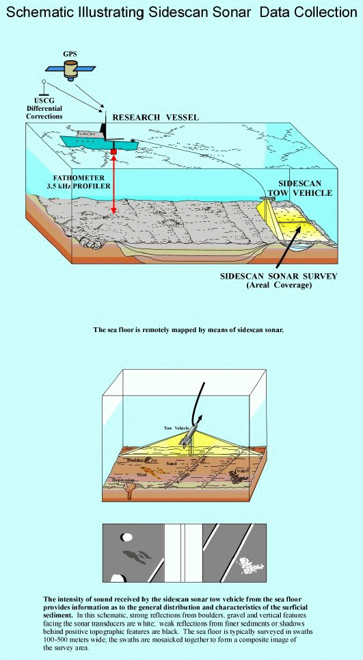
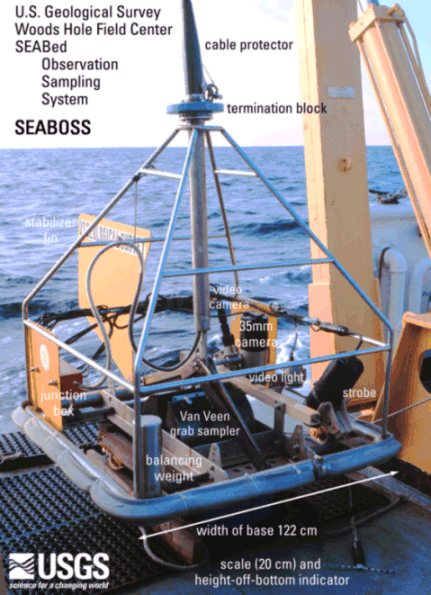
Sidescan sonar imagery, bathymetry, high-resolution seismic-reflection subbottom profiles and navigational data were collected along tracks spaced 150 m apart aboard the RV Asterias during June 1997 (figs. 2, 8). The bathymetric data were collected using a 200-kHz echo sounder, logged digitally to a computer, and corrected for the approximately 1.89-m tidal range in the study areas by adjusting the measured depth values to the predicted mean sea-level (MSL) for the harbor entrance of New Haven, Connecticut using commercially available software. The sidescan sonar data were collected using an Edgetech sidescan sonar system set to sweep 100-m to either side of the shiptrack and logged digitally to 8-mm tape on an ISIS data acquisition system. The subbottom data, which were used to interpret the stratigraphy, were collected in analog form using an Ocean Research Equipment 3.5-kHz profiler transmitting at a 0.25-s repetition rate. Ship position was determined with a differential Global Positioning System (GPS); navigational data were logged on a computer at 10-second intervals.
The sidescan sonar data were processed according to procedures summarized by Danforth and others (1991) and Paskevich (1992a; 1992b). Briefly, the sonar data were multiplexed, filtered to convert the data into a processing format and to remove speckle noise and corrected for slant-range distortions. Additional corrections were applied to compensate for signal attenuation and dropped lines in the sonar data. A contrast enhancement based on the dynamic range of the data was applied, ship navigation was merged with the sonar data, and the data were geographically oriented and displayed on a Mercator grid.
After this preliminary processing, these data were used to make the composite digital mosaics. Alternating strips of sonar data were placed in their proper geographic location at the appropriate scale and projection (Paskevich (1992c). The adjacent sonar images were matched for tone, unwanted data (where two images overlapped) were digitally trimmed off, and images were progressively combined into composite digital images. Registration between the shiptrack navigation and the strips of sidescan sonar data are generally good throughout both of the study areas. The final digital mosaics, which have a 1-m pixel size, were output to film, photographically enlarged, and interpreted (figs. 4, 5, 10, 11).
Surficial sediment (0-2 cm below the sediment-water interface) sampling was attempted and bottom photography performed at 66 locations in New Haven Harbor and 25 locations near the New Haven Dumping Ground during March 1998 aboard the RV John Dempsey using a Van Veen grab sampler equipped with a video camera system. The photographic system was used to appraise intra-station bottom variability, faunal communities, and sedimentary processes and to observe bedrock outcrops and boulder fields where samples could not be collected.
In the laboratory, the sediment samples were disaggregated and wet sieved to separate the coarse and fine fractions. The fine fraction (less than 62 microns) was analyzed by Coulter Counter (Shideler, 1976); the coarse fraction was analyzed by sieving (gravel) and by rapid sediment analyzer (sand; Schlee, 1966). The data are salt corrected.
Because biogenic carbonates shells commonly form in situ, they usually are not considered to be sedimentologically representative of the depositional environment. Therefore, bivalve shells and other biogenic carbonate debris were manually removed from the gravel fraction. Size classifications are based on the method proposed by Wentworth (1929). The verbal equivalents were calculated using the inclusive graphics statistical method (Folk, 1974) and are based on the nomenclature proposed by Shepard (1954). A detailed discussion of the laboratory methods employed are given in Poppe and others (1985). The field methods, station navigation, raw grain-size data, associated statistics, and detailed descriptions of the bottom photography are reported in Poppe and others (1998d).
The map of surficial sediment distribution shown in figure 7 is based on data from the sediment sampling and bottom photography stations, on tonal changes in backscatter on the sidescan sonar image, and on the bathymetry.
The corrected bathymetry was contoured at 1-m intervals to facilitate an understanding of the surficial geology and general benthic character (figs. 2, 8). This perspective is important because the bathymetry affects the evolution and stability of the physical and biological systems within the study areas.
New Haven Harbor
The sea floor in the western part of the New Haven Harbor study area has a smooth gentle gradient that progressively slopes toward the south from Oyster River Point and toward the southwest from an elongate bathymetric high that extends southeast from West Haven past the middle breakwater (fig. 2). Steeper gradients are primarily associated with the area just north of the gap between the middle and west breakwaters.
The eastern part of the study area has a more complex morphology. Isolated bathymetric highs, such as Old Head Reef and the Chimneys, are concentrated near the east breakwater and reflect bedrock outcrops. Isolated bathymetric lows include an area northwest of the gap between the east breakwater and Morgan Point and an abandoned borrow pit (Bohlen and others, 1996) in Morris Cove, a large shallow embayment at the southeastern limit of the inner harbor.
The study area is bisected by the New Haven Harbor navigational channel. This channel, which is periodically dredged to over 10 m MSL (Bothlen and others, 1996), has steep sides and exceeds 15 m in depth in an isolated depression between the middle and east breakwaters. This is the deepest part of the study area. Broad shallows, notably Shag Bank and Morris Cove, flank the navigation channel over most of its length.
New Haven Dumping Ground
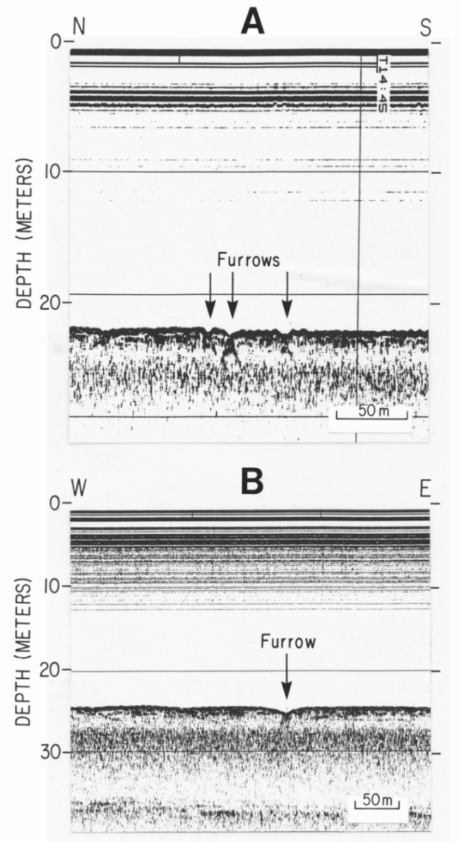
The sea floor around the New Haven Dumping Ground has a relatively smooth gradient that slopes gradually toward the southeast (fig. 8). Water depths in the northwestern corner of the study area are about 17-18 m and about 24-25 m in the southeastern corner. Isolated bathymetric highs, which are related to dredge-spoil mounds and the materials used to cap them (Morris and others, 1996), occur in the central and northwestern part of the study area. Small-scale linear depressions (0.4-0.5 m; fig. 9) are concentrated in the eastern and southern parts of the study area, but, because of the 10-second sampling rate and the east-northeast trend of the features that is nearly parallel to the shiptrack, these features are too faint to map bathymetrically.
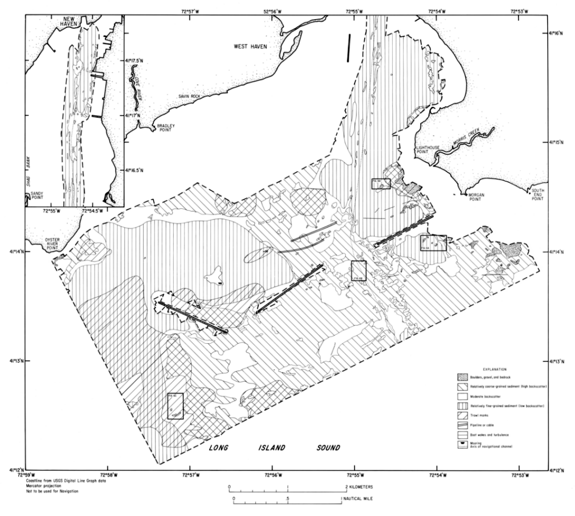
The sidescan sonar mosaics (figs. 4, 10) reveal acoustic images of the sea floor that, when combined with the subbottom and bathymetric data, can be used to interpret the surficial geology (figs. 5, 11). Distinctive acoustic patterns present on the mosaics include: complex patches of high and low backscatter with individual high-backscatter targets, areas of higher backscatter (light tones), areas of moderate backscatter, areas of lower backscatter (dark tones), and alternating lines of high and low backscatter (sedimentary furrows). Boundaries between patterns are commonly gradational; backscatter is not uniform throughout these areas. Water column phenomena, such as ship wakes and turbulence around obstructions, and anthropogenically produced features, such as the navigational channel, trawl marks, culch (clean shell debris used for setting juvenile oysters) beds, pipelines and (or) cables, anchor scars, and dredge-spoil disposal mounds, are also present on the images.
New Haven Harbor
The complex patches of high and low backscatter with individual high-backscatter targets (objects) coincide with areas characterized by bedrock outcrops and (or) concentrations of boulders and gravel (figs. 3A,B; 6A). This acoustic pattern occurs in the shallower waters around Oyster River, Lighthouse, and Morgan Points and within a southeast-trending band that extends across the eastern end of the middle breakwater.
Areas characterized by relatively high backscatter, which primarily coincide with exposures of relict glaciodeltaic deposits, occur adjacent to the deposits of boulders and gravel off Oyster River, Lighthouse, and Morgan Points and in a broad band that extends southeast from West Haven across the central part of the study area. The high backscatter is produced by the coarse-grained sediments. Elongate patches of alternating high and low backscatter, which occur within the southern part of the navigational channel, are interpreted to be sand waves (fig. 6B).
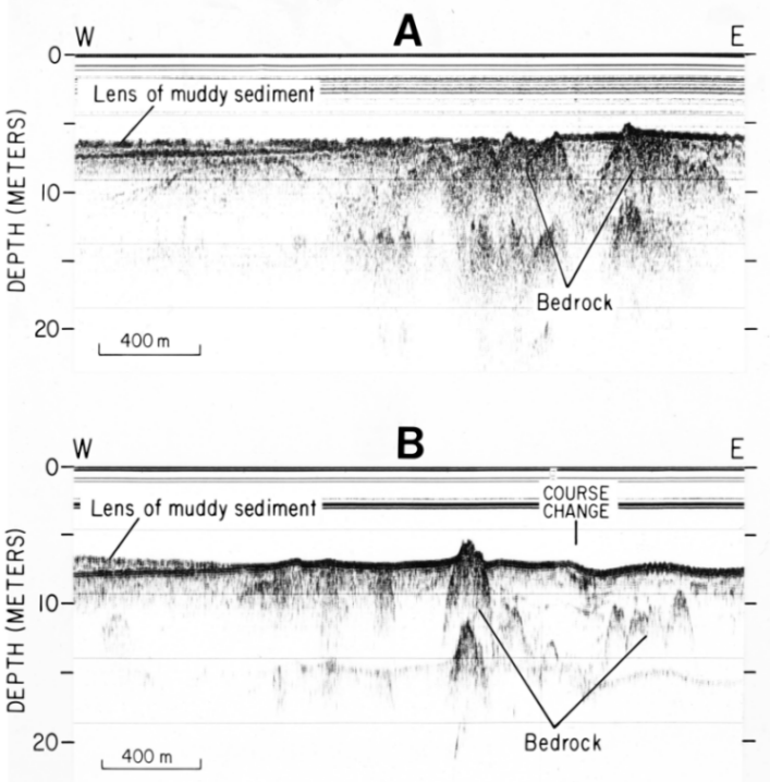
Areas characterized by relatively low backscatter, which coincide with accumulations of fine-grained Holocene marine sediment, include the main navigational channel north of Lighthouse Point, Morris Cove, patches north and south of the East Breakwater, and the area that extends northwest from the Middle Breakwater around the northern end of the West Breakwater and along most of the western boundary of the study area. Subbottom profiles (fig. 3A, B) show that the deposits of finer grained sediments near the breakwaters occur in lenses that overlie the high-backscatter glaciodeltaic sediments and thin toward their edges. Maximum thicknesses for the lenses south of the east breakwater and northwest of the middle breakwater are about 1.5 and 2.0 m, respectively. The small patches of higher backscatter that occur within the low backscatter areas in and adjacent to the channel north of Lighthouse Point and around the abandoned borrow pit in Morris Cove are largely artifacts of bathymetric changes that affect the angle of incidence of the sonar.
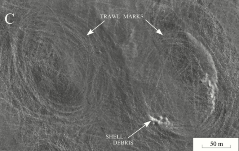
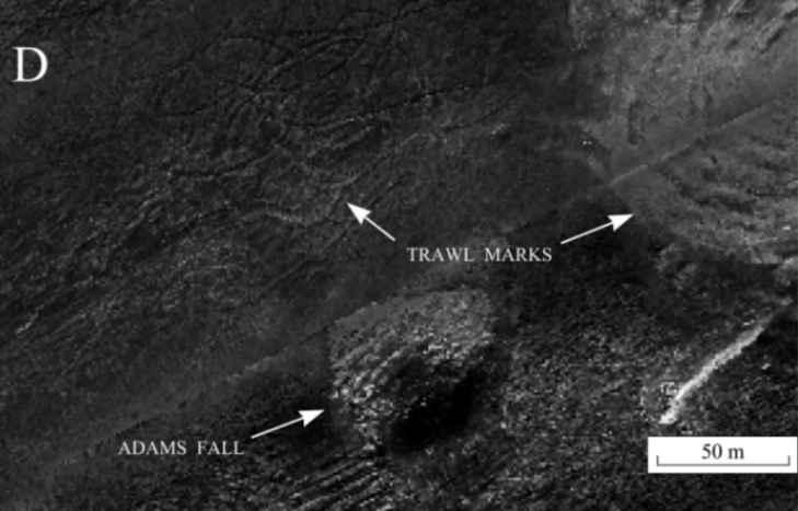
Shallow curvilinear and looping depressions, interpreted to represent trawl marks associated with shellfishing, occur throughout much of the study area, but are most conspicuous along the western edge of the image (fig. 6C), in scattered patches inside of the breakwaters, and near Oyster River and Lighthouse Points (fig. 6D). The trawl marks, which coincide with active shell-fishing leases, owe their looped appearance to 1) the side-mounted deployment of trawl gear that requires the fishing vessel to turn toward that side to minimize abrasion against the hull, and 2) the practice of trying to stay near an area once a concentration of hard clams is discovered. Broader high-backscatter looping elevations along the southern edge of the study area are interpreted to represent relatively recently constructed culch beds. The navigational channel and dredge marks from two piplines or cables are also visible in the central part of the image.
New Haven Dumping Ground
The New Haven Dumping Ground sidescan sonar image can be divided into two general provinces (figs. 10,11). The first province, which extends over the central and northwestern parts of the study area, is characterized by complex patches of high and low backscatter and curvilinear streaks of high backscatter. The high backscatter results from a combination of coarser grained sediments in the dredge spoils or materials used to cap the spoils, and the angle of incidence of the sonar against the sides of disposal mounds (Morris and others, 1996). The curvilinear streaks of high backscatter are best developed in the central part of the study area and represent disposal from hopper dredges or scows that discharged the dredged materials while under weigh, leaving a swath across the seabed. Halos of low backscatter around some of the disposal piles may represent the effect of density surges associated with the impact of dredged materials on the bottom or the subsequent slower hemipelagic sedimentation of the diffuse plume of residual material (Schubel and others, 1979).
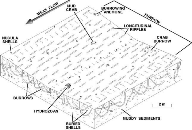
The second province, which covers the eastern and southernmost parts of the study area, is characterized by low backscatter, caused by finer grained sediment, and numerous linear depressions, interpreted to be sedimentary furrows. These bedforms, which appear as thin paired lines of high and low backscatter (fig. 12A), trend east-northeast, are irregularly spaced, and have indistinct troughs with gently sloping walls (figs. 9, 13). Most of the furrows are symmetrical; but where unsymmetrical, the southern (or downslope in the regional bathymetry) wall is usually steeper. The average width and relief of the furrows is 9.2 m and 0.4 m, respectively. The furrows average about 206 m long, but range from 30 m to 1,315 m in length. Longitudinal ripples, bioturbation, and nutclam shell debris are common within the furrows.
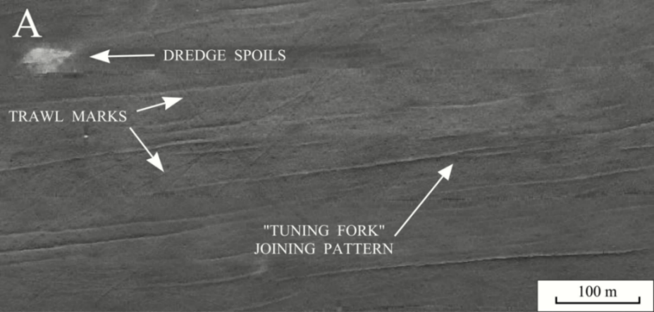
Although most of the sedimentary furrows appear to gradually taper out, some furrows show a "tuning fork" joining pattern. These junctions open predominantly toward the east (fig. 12A), but some open toward. A few of the sedimentary furrows are associated with dredge-spoil mounds (fig. 12B), but most are not associated with any obstacles.
Shallow linear depressions, interpreted to be trawl marks, are most evident in the eastern part of the study area. Whether this association is because trawl marks are more visible in the fine-grained sediments or whether it is because these muddy sediments are a preferred habitat is unknown. The trawl marks can be differentiated from the furrows in that they are much fainter, usually curved, and show no preferential orientation. Some of the lineations, especially those toward the west, may represent anchor scars.
Surficial Sediment Distribution
Sedimentary environments are mapped within the study areas on the basis of lithology, texture, and faunal assemblage. Contacts between these environments are inferred because the transitions between the various lithologies are gradational and lateral changes in texture are seldom abrupt.
New Haven Harbor Survey
The locations of the sampling and photographic stations and the surficial sediment distribution for the New Haven Harbor study area are shown in figure 7. The finest grained sediments in this study area are organic-rich (Duxbury, 1963; Turkeian and others, 1972), poorly sorted, finely skewed silts and clayey silts that dominate in and adjacent to the main shipping channel north of Lighthouse Point, within the abandoned borrow pit in Morris Cove, northwest of the middle breakwater, and in smaller patches just north and south of the eastern breakwater. Slightly coarser very poorly sorted, coarsely skewed, leptokurtic sandy silts occur in the shallower areas within Morris Cove and west and north of the western breakwater. These muddy areas are extensively bioturbated; most bottom features originate from biologic activity. Amphipod communities, worm tubes, shrimp burrows, snails, and mud crabs are common.
The muddy sediments progressively grade into bands of silty sand and coarser grained sediments as water depth decreases. The silty sands are typically very poorly sorted, nearly symmetrical to finely skewed, and platykurtic. Although faint current ripples occur, the effects of bioturbation are still more evident. Scattered shells and shell debris are present; crabs, worm tubes, hydrozoans, bivalves, and gastropods are common components in the faunal assemblage.
Sands occur off Oyster River Point and are the dominate lithology in a broad band across the central part of the study area. This band extends south-southwest from West Haven along the seaward-trending bathymetric high, in and adjacent to the navigational channel south of Lighthouse Point, in the vicinity of the gap between the middle and east breakwaters, and across much of the study area outside the breakwaters. The sands shoreward of the breakwaters are typically fine to medium grained, poorly sorted, and strongly finely skewed to nearly symmetrical. The sands near the gap between the middle and eastern breakwaters are typically medium grained, moderately well sorted, nearly symmetrical to coarsely skewed, and leptokurtic. Sorting decreases and the distributions become finely skewed and very leptokurtic in the sand outside the breakwaters. Current ripples are ubiquitously present; decreased visibility due to resuspension during a passing storm was observed in the bottom video. Locally, shells (oyster, razor, and quahog) and shell debris liter the bottom and concentrate in the ripple troughs. Starfish, hermit crabs, welk, clam burrows, and hydrozoans are common.
Gravelly sediments, which tend to be very poorly sorted and bimodal, are concentrated in shallow environments around Lighthouse, Morgan, and Oyster River Points and in a narrow band just southeast of the middle breakwater. Starfish and oyster, razor clam, and quahog shell and shell debris are common; hydrozoans grow on the shell material.
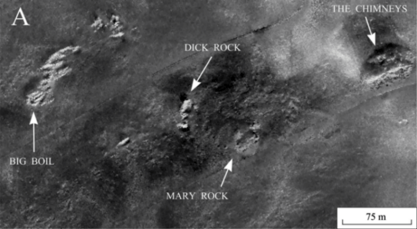
Sidescan sonar and bottom photography revealed the presence of boulders and bedrock adjacent to Morgan or Oyster River Points, on Old Head Reef, and at scattered outcrops southeast of the eastern breakwater (i.e. Big Boil and The Chimneys). Sponges, algae, and seaweed are attached to the rocks; patches of rippled sand with scattered shells occur between the boulders. A thin (<2 cm), possibly seasonal, layer of fine-grained, presumably hemipelagic, detritus covers the rocks. The limited thickness of this layer suggests that it is episodically removed by storm-generated currents.
New Haven Dumping Ground Survey
Muddy sediments dominate in the vicinity of the New Haven Dumping Ground. These sediments are generally poorly sorted siliciclastic silts and clayey silts with unimodal, finely skewed to nearly symmetrical, mesokurtic distributions. A current-swept appearance characterizes the bottom; scour around coarser grains, sediment accumulations in the current shadows of obstacles, and saltating shells were observed in the bottom video. Faint longitudinal ripples, which trend east-northeast are common. Nut clam (nucula) shells, burrows (shrimp, clam, mud crab, and lobster), anemones, worm tubes, hydrozoans, and amphipod communities are present in the heavily bioturbated bottom.
Very poorly sorted fine-grained sands, silty sands, and sandy silts are common within the New Haven Dumping Ground portion of the study area. These coarser grained sediments reflect the presence of dredge spoils, or the materials used to cap the spoils (Morris and others, 1996). Identifiable anthropogenic debris (i.e. wires, cables, pipe) are occasionally present in the bottom video at these stations. Amphipod communities, worm tubes, and shrimp and crab burrows are common in the areas characterized by spoils.
New Haven Harbor
High-energy environments prevail in the shallow waters around Oyster River, Lighthouse, and Morgan Points. Strong tidal currents and wind-driven waves prevent the deposition of Holocene marine sediments and winnow the finer fraction from the sediments leaving exposed bedrock and lag deposits of boulders and gravel.
As water depth increases, the exposure to storm and tidal currents decreases. Conditions favoring erosion are replaced by environments characterized by reworking. Current ripples in the sandy areas and resuspension observed in the bottom video reflect this constant reworking by the tidal and storm currents.
Fine-grained sediments are accumulating in lower energy environments protected from the strong tidal and storm conditions, such as in the navigational channel north of Lighthouse Point, Morris Cove, and lenses adjacent to the breakwaters. Because the locations and the surrounding coarse-grained sediments suggest that the lenses are associated with the breakwaters, gross sedimentation rates can be estimated from thickness of the fine-grained sediment lenses and the age of the breakwaters. Construction of the first breakwater was authorized in 1879, and construction of all three breakwaters was completed by 1915 (U.S. Army Corps of Engineers, 1988). Although deposition of the fine-grained sediments probably began soon after construction was initiated, we calculate maximum sedimentation rates during the 82-year period between when construction was completed and the subbottom data were collected of 1.8 and 2.4 cm/yr for areas south of the east breakwater and northwest of the middle breakwater, respectively.
New Haven Dumping Ground
Although the deeper (>15 m) waters of the central sound are long-term depositional areas characterized by fine-grained cohesive sediments and relatively weak bottom-current regimes (Gordon, 1980; Signell and others, 1998; Knebel and others, 1999), our data reveal the localized presence of sedimentary furrows and longitudinal ripples. These bedforms are erosional and typically form in environments which have recurring, directionally stable, and occasionally strong currents (Dyer, 1970; Hollister and others, 1974; Reineck and Singh, 1980; Flood, 1983). However, the lack of abrupt transitions, faint appearance of the associated longitudinal ripples, and abundance of bottom animal tracks suggest that the processes, which created the furrows in north-central Long Island Sound, are only intermittently active. Previous work near the New Haven Dumping Ground (Gordon and others, 1972) has shown that resuspension is the major mechanism of bottom sediment transport, that suspended sediment does not settle out between tidal cycles, and that the principal factor controlling resuspension is the speed of the tidal stream and intensity of wave action over a period of days. Therefore, resuspension at the dumping ground should be larger during spring tides, and weaker during neap tides. Although the amount of suspended sediment at any one site is highly variable, data from Gordon and others (1972) also show that the average concentration of suspended sediment in the water column at the dumping ground exceeded 13 mg/cm2 of bottom.
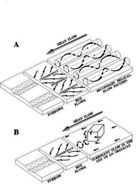
The "tuning fork" joining patterns, which usually open toward the east, indicate net westward sediment transport (fig. 12A; Flood, 1983). However, because adjacent furrow junctions do occasionally open in opposite directions, these joining patterns also suggest that the tidal regime is important to furrow formation and that the furrows can form when water flows in either direction. Studies by Flood (1981, 1983) show that coarse-grained sediments are also important to the initiation and development of furrows in muddy sediments. Coarse sediments available within the study area include nutclam shells and fine sand associated with the dredge spoils. Based on these coarse materials, at least two possible mechanisms could produce the furrows observed in north-central Long Island Sound. In the first mechanism adapted from Flood (1983), helical secondary-flow patterns in the boundary layer align more mobile, coarser nutclam shell debris in convergent flow zones (fig. 14A). Furrow development is initiated due to enhanced erosion within the elongate shell beds by scour around individual shells and from impacts by saltating shells. The furrows are lengthened as the shells are moved downstream in the bottom currents. Alternately, in a mechanism adapted from McLean (1981), furrows are initiated in the turbulent wakes produced by disposal mounds. Sand grains eroded from the disposal mounds, which are relatively easy to transport, subsequently abrade the lengthening furrows into the muddy seabed (figs. 12B, 14B). Although cuspate high-backscatter lobes extend off both the eastern and western sides of some of the disposal mounds associated with furrows, suggesting reworking by tidal currents (fig. 12B), most of the furrows in north-central Long Island Sound are not associated with disposal mounds or identifiable obstacles.
The elongate geometry and regional bathymetric contours of Long Island Sound combine to constrain the dominant tidal and storm currents to east-west flow directions and permit the development of the erosional bedforms. Through the development of sedimentary furrows and longitudinal ripples, fine-grained cohesive sediment can be remobilized and, at least episodically, made available for transport farther westward into the estuary.
This survey was conducted in cooperation with the State of Connecticut, Department of Environmental Protection, Geological and Natural History Survey. We thank Dave Olmsted who captained the Woods Hole Oceanographic Institution vessel RV Asterias and Dave Simpson, Miles Peterle, and Kurt Gottschall of the Connecticut Department of Environmental Protection for providing shipboard support aboard the RV John Dempsey and onshore logistical support. This map has benefitted from critical reviews by Steve Colman and Bob Oldale (both USGS). Any use of trade, product, or firm names is for descriptive purposes only and does not imply endorsement by the U.S. Government or the State of Connecticut.
Bohlen, W.F., Horward-Strobel, M.M., Cohen, D.R., and Mortom, E.T., 1996, An investigation of the dispersion of the sediments resuspended by dredging operations in New Haven Harbor: Disposal Area Monitoring System, U.S. Army Corps of Engineers, DAMOS Contribution 112, 202 p.
Boyd, M.B., Saucier, R.T., Keeley, J.W., Montgomery, R.L.,, Brown, R.D., Mathis, D.B., Guice, C.J., 1972, Disposal of dredged spoil - problem identification and assessment and research program development: U.S. Army Engineer Waterways Experiment Station Technical Report H-72-8, 121 p.
Cambell, K.J., Orange, A.S., and Lenard, J.E., 1974, Geophysical investigation of bottom and subbottom characteristics, New Haven Harbor, Connecticut: Final Report to the U.S. Army Corps of Engineers, Northeast District, Waltham, MA, 39 p.
Caruso, D, Quarrier, I., and Starzec, E. (Eds.), 1995, Embassy=s Complete Boating Guide and Chartbook - Long Island Sound, New York Harbor to Block Island, Rhode Island: Old Saybrook, Connecticut, Embassy marine Publishing, 418 p.
Danforth, W.W., O'Brien, T.F., and Schwab, W.C., 1991, USGS image processing system: near real-time mosaicking of high resolution side scan SONAR data: Sea Technology, v. 32, p. 54-60.
Duxbury, A.C., 1963, A hydrographic survey of New Haven Harbor, 1962-1963: Connecticut Water Resources Bulletin No. 3A, 105 p.
Dyer, K.R., 1970, Linear erosion furrows in Southhampton Water: Nature, v. 225, p. 56-58.
Flint, R.F., 1965, The surficial geology of the New Haven and Woodmont Quadrangles, with map: State Geological and natural History Survey of Connecticut, Quadrangle Report No. 18, 42 p., 3 sheets.
Flood, R.D., 1981, Distribution, morphology, and origin of sedimentary furrows in cohesive sediments, Southhampton Water: Sedimentology, v. 28, p. 511-529.
Flood, R.D., 1983, Classification of sedimentary furrows and a model for furrow initiation and evolution: Geological Society of America Bulletin, v. 94, p. 630-639.
Folk, R.L., 1974, The petrology of sedimentary rocks: Hemphill Publishing Co., Austin, 182 p.
Flint, R.F., and Gebert, J.A., 1976, Latest Laurentide ice sheet - new evidence from southern New England: Geological Society of America Bulletin, v. 87, p. 182-188.
Goldsmith, Richard, 1982, Recessional moraines and ice retreat in southeastern Connecticut: In G.J. Larson and B.D. Stone (editors), Late Wisconsinan Glaciation of New England, Kendall/Hunt Publishing, Dubuque, p. 61-76.
Gordon, R.B., Rhoads, D.C., and Turekian, K.K., 1972, The environmental consequences of dredge spoil disposal in central Long Island Sound: The New Haven Spoil Ground and New Haven Harbor: Report to the U.S. Army Corps of Engineers, Yale University, 41 p.
Gordon, R.B., 1980, The sedimentary system of Long Island Sound: Advances in Geophysics, v. 22, p. 1-36.
Hollister, C.D., Flood, R.D., Johnson, D.A., Lonsdale, Peter, and Southard, J.B., 1974, Abyssal furrows and hyperbolic echo traces on the Bahama Outer Ridge, Geology, v. 2, p. 395-400.
Knebel, H.J., Signell, R.P., Rendigs, R.R., Poppe, L.J., and List, J.H., 1999, Sea floor environments in the Long Island Sound estuarine system: Marine Geology, v. 155, in press.
Kopplemann, L.E., Weyl, P.K., Gross, M.G., and Davies, D.S., 1976, The Urban Sea - Long Island Sound: Praeger Publishers, New York, 223 p.
Lewis, R.S., and Stone, J.R., 1991, Late Quaternary stratigraphy and depositional history of the Long Island Sound basin: Connecticut and New York: Journal Coastal Research, Special Issue 11, p. 1-23.
Lewis, R.S., and Needell, S.W., 1987, Maps showing the stratigraphic framework and quaternary geologic history of eastern Long Island Sound: U.S. Geological Survey Miscellaneous Field Studies Map MF-1939-A, 7 p., 3 sheets.
Long Island Sound Study, 1994, The Long Island Sound Study - The Comprehensive Conservation and management Plan, 168 p.
McLean, S.R., 1981, The role of non-uniformroughness in the formation of sand ribbons: Marine geology, v. 42, p. 79-102.
Moffett, A.M., Poppe, L.J., and Lewis, R.S., 1994, Trace metal concentrations in sediments from eastern Long Island Sound: U.S. geological Survey Open-File Report 94-620, 17 p.
Morris, J.T., Charles, J., Inglin, D.C., 1996, Monitoring surveys of the New Haven Capping Project, 1993-1994: Disposal Area Monitoring System, U.S. Army Corps of Engineers, DAMOS Contribution 111, SAIC Report No. 319, 109 p.
Needell, S.W., Lewis, R.S., and Colman, S.M., 1987, Maps showing the Quaternary geology of east-central Long Island Sound: U.S. Geological Survey Miscellaneous Field Studies Map MF-1939-B, 3 sheets.
Paskevich, Valerie, 1992a, Woods Hole Image Processing System software implementation: using NetCDF as a software interface for image processing: U.S. Geological Survey Open-File Report 92-25, 66 p.
Paskevich, Valerie, 1992b, Digital processing of side-scan sonar data with the Woods Hole Image Processing System software: U.S. Geological Survey Open-File Report 92-204, 9 p.
Paskevich, Valerie, 1992c, Digital mapping of side-scan sonar data with the Woods Hole Image Processing System software: U.S. Geological Survey Open-File Report 92-536, 87 p.
Poppe, L.J., Eliason, A.H., and Fredericks, J.J., 1985, APSAS - An automated particle size analysis system: U.S. Geological Survey Circular 963, 77 p.
Poppe, L.J., Lewis, R.S., and Moffett, A.M., 1992, The texture of surficial sediments in northeastern Long Island Sound: U.S. Geological Survey Open-File Report 92-550, 13 p.
Poppe, L.J., Lewis, R.S., Zajac, R.N., Twichell, D.C., Schmuck, E.A., Parolski, K.F., and DiGiacomo-Cohen, M.L., 1997a, Sidescan sonar image, surficial geologic interpretation, and bathymetry of the Long Island Sound sea floor off Hammonasset Beach State Park, Connecticut: U.S. Geological Survey Geologic Investigations Map MF-2588, 2 sheets.
Poppe, L.J., Denny, J.F., Parolski, K.F., Knebel, H.J., Lewis, R.S., and DiGiacomo-Cohen, M.L., 1997b, Sidescan sonar image and geologic interpretation of the sea floor near Falkner Island, Connecticut: A Coastal National Wildlife Refuge: Geological Society of America, v. 29, p. 90.
Poppe, L.J., Denny, J.F., Parolski, K.F., Knebel, H.J., Signell, R.P., List, J.H., Lewis, R.S., and DiGiacmo-Cohen, M.L., 1998a, Morphology and sedimentary environments of the Roanoke Point Shoal in southeastern Long Island Sound: EOS, v. 79, p. 129.
Poppe, L.J., Lewis, R.S., Denny, J.F., Parolski, K.F., DiGiacomo-Cohen, M.L. and Tolderlund, D.S., 1998b, Sidescan sonar image, surficial geologic interpretation, and bathymetry of the Long Island Sound sea floor in Niantic Bay and vicinity, Connecticut: U.S. Geological Survey Geologic Investigations Map I-2625, 2 sheets.
Poppe, L.J., Lewis, R.S., Denny, J.F., Parolski, K.F., and DiGiacomo-Cohen, M.L., 1998c, Sidescan sonar image, surficial geologic interpretation and bathymetry of Fishers Island Sound, Connecticut, New York, and Rhode Island: U.S. Geological Survey Geologic Investigations Map I-2640, 2 sheets.
Poppe, L.J., Robinson, A.C., Blackwood, Dann, Lewis, R.S., and DiGiacomo-Cohen, M.L., 1998d, The distribution of surficial sediments in New Haven Harbor, Connecticut and the New Haven Dumping Grounds, north-central Long Island Sound: U.S. Geological Survey Open-File Report 98-217, 27 p.
Reineck, H.E., and Singh, I.B., 1980, Depositional Sedimentary Environments: Springer-Verlag, New York, 549 p.
Richards, D.R., 1988, New Haven Harbor numerical model study: Final Report prepared for the U.S. Army Corps of Engineers, New England Division, Waltham, MA.
Rodgers, John (compiler), 1985, Bedrock Geologic Map of Connecticut: Connecticut Natural Resources Atlas Series, Connecticut Geological and Natural History Survey, Department of Environmental Protection, Hartford, Connecticut, scale 1:125,000, 2 sheets.
Sanders, J.E., 1965, Sediment-filled deep valleys underlying New Haven Harbor, revealed by continuous seismic profiling using sparker and pneumatic sources: Transactions, American Geophysical Union, v. 46, p. 105.
Schafer, J.P., and Hartshorn, J.H., 1965, The Quaternary of New England, In: Wright, H.E., and Frey, D.G., (eds.), The Quaternary of the United States: Princeton, N.J., Princeton University Press, p. 113-127.
Schlee, J., 1966, A modified Woods Hole rapid sediment analyzer: Journal Sedimentary Petrology, v. 30, p. 403-413.
Schubel, J.R., Wise, W.M., and Schoof, J. (Eds.), 1979, Questions about dredging and dredged material disposal in Long Island Sound: Marine Sciences Research Center, State University of New York Special Publication 28, reference 79-11, 136 p.
Shepard, F.P., 1954, Nomenclature based on sand-silt-clay ratios: Journal Sedimentary Petrology, v. 24, p. 151-158.
Shideler, G.L., 1976, A comparison of electronic particle counting and pipet techniques in routine mud analysis: Journal of Sedimentary Petrology, v. 42, p. 122-134.
Signell, R.P., Knebel, H.J., List, J.H., and Farris, A.S., 1998, Physical processes affecting sedimentary environments of Long Island Sound: In: M. Spaulding and A. Blumberg (eds.) Proceedings, 5th International Conference on Estuarine and Coastal Modeling, American Society of Civil Engineers,.
Stone, B.D., and Borns, H.W, 1986, Pleistocene glacial and interglacial stratigraphy of New England, Long Island, and adjacent Georges bank and Gulf of Maine. In: Sibrava, V., Bowen, D.Q., and Richmond, G.M. (Eds.), Quaternary Glaciations in the Northern Hemisphere, Oxford, Pergammon Press, pp. 39-52.
Stone, J.R., Schafer, J.P., London, E.H., and Thompson, W.B., 1992, Surficial materials map of Connecticut: U.S. Geological Survey Surficial Materials Map, scale 1:125,000, 2 sheets.
Turekian, K.K., Berner, R.A., and Gordon, R.B., 1972, Marine sediments, New Haven Harbor, Connecticut - Results of analyses and proposals for dredge spoil disposal: Addendum 12 of Environmental report on the Coke Works Site, Final report to the United Illuminating Co, 134 p.
Twichell, D.C., Zajac, Roman, Poppe, L.J., Lewis, R.S., Cross, VeeAnn, and Nichols, David, 1997, Sidescan sonar image, surficial geological interpretation, and bathymetry of the Long Island Sound sea floor off Norwalk, Connecticut: U.S. Geological Survey Geologic Investigations Map I-2589, 2 sheets, scale 1:15,000.
Twichell, D.C., Zajac, R.N., Poppe, L.J., Lewis, R.S., Cross, V.A., Nichols, D., and Digiacomo-Cohen, M.L., 1998, Sidescan sonar image, surficial geologic interpretation, and bathymetry of the Long Island Sound sea floor off Milford, Connecticut: U.S. Geological Survey Geologic Investigations Map I-2632, 2 sheets, scale 1:15,000.
U.S. Army Corps of Engineers, 1988, Rivers and Harbors, Rhode Island and Connecticut: Project maps, v. 3, p. 140.
Wentworth, C.K., 1929, Method of computing mechanical composition of sediments: Geological Society of America Bulletin, v. 40, p. 771-790.
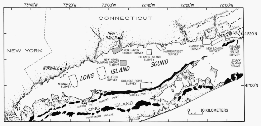
Figure 1. Map showing the locations of New Haven Harbor and New Haven Dumping Ground study areas. Also shown are the major onshore moraines, and the locations of other sidescan sonar surveys being completed as part of this series (Norwalk: Twichell and others (1997); Milford: Twichell and others (1998); Roanoke Point: Poppe and others (1998a); Falkner Island: Poppe and others (1997b); Hammonasset: Poppe and others (1997a); Niantic Bay: Poppe and others (1998b); New London: Poppe and others (1992); Moffett and others (1994); Fishers Island Sound: Poppe and others (1998c).
Figure 2. Bathymetric map of the New Haven Harbor study area. Contour interval is 1 meter. Depths have been corrected for tides and are adjusted to mean sea level. Fine dashed lines represent tracks along which the geophysical data were collected.
Figure 3. Subbottom profiles from the New Haven Harbor study area. Locations of the profiles are shown in figure 2. A) Profile from south of the eastern breakwater showing bedrock outcrops and the thin surficial lens of muddy sediments. B)Profile showing the bedrock control of the bathymetric high that extends south from West Haven and the thin surficial lens of muddy sediments northwest of the middle breakwater.
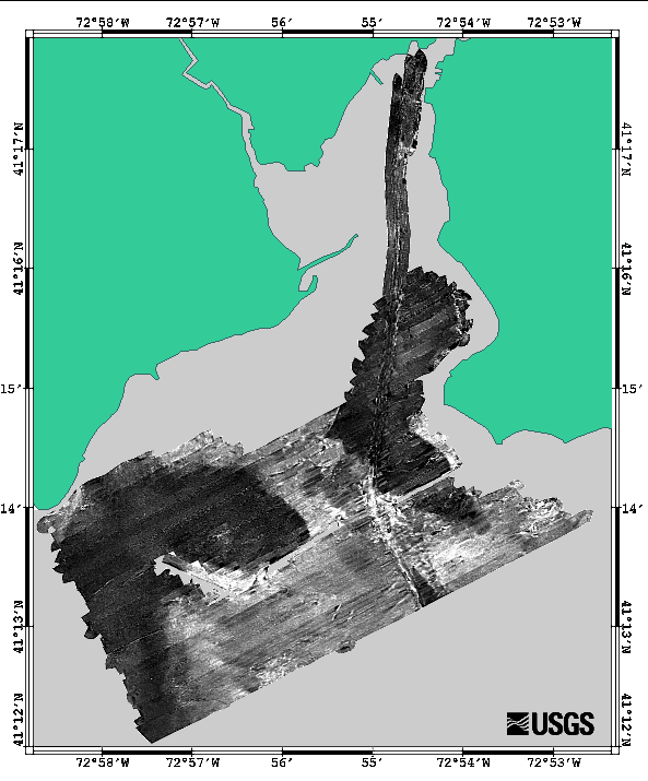
Figure 4. Sidescan sonar mosaic of the sea floor in New Haven Harbor, Connecticut. Light tones on the image represent areas of high backscatter; dark tones represent areas of low backscatter.
Figure 5. Interpretation of the New Haven Harbor sidescan sonar mosaic. Different patterns are defined in the explanation and discussed in the text. Location of the sections of sidescan sonar record shown in figure 6 are plotted on the interpretation.
Figure 6. Sections of sidescan sonar records from New Haven Harbor. A) Image shows bedrock outcrops southwest of Morgan Point and the intervening fine-grained sediments. B) Image shows small-scale sand waves, suggestive of sediment transport, from in the navigational channel. C) Image shows looped curvilinear trawl marks and mounded shell debris, both resulting from commercial shell fishing. D) Image from off Lighthouse Point showing two varieties of trawl marks and Adams Fall, a bedrock outcrop. Location of sections are shown in figure 5.
Figure 7. Map showing the distribution of surficial sediments and the locations of the sampling and bottom photography stations (solid circles) in New Haven Harbor. Interpretation of the sediment distribution is based on data from these stations, on tonal changes in backscatter on the sidescan sonar image (fig. 4), and on the correlation of the textural and backscatter data with the bathymetry (fig. 2).
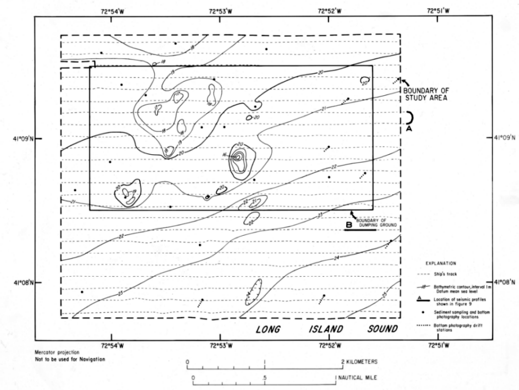
Figure 8. Bathymetric map of the New Haven Dumping Ground study area. Contour interval is 1 meter. Depths have been corrected for tides and are adjusted to mean sea level. Fine dashed lines represent tracks along which the geophysical data were collected. Locations of selected seismic-reflection profiles and sediment sampling and bottom photography stations are indicated.
Figure 9. Subbottom profiles showing the morphology of the sedimentary furrows. Locations of the profiles are shown in figure 8. A) Cross section across three furrows. Data collected while turning to come on line. B) Oblique cross section of a well-developed furrow. Note slight asymmetry of the furrow walls.
Figure 10. Sidescan sonar mosaic of the sea floor around the New Haven Dumping Ground in north-central Long Island Sound. Light tones on the image represent areas of high backscatter; dark tones represent areas of low backscatter.
Figure 11. Interpretation of the New haven Dumping Ground sidescan sonar mosaic. Different patterns are defined in the explanation and discussed in the text. Location of the sections of sidescan sonar record shown in figure 12 is plotted on the interpretation.
Figure 12. Sections of sidescan sonar records from the New Haven Dumping Ground. Location of sections are shown in figure 11. A) Image shows the "tuning fork" joining pattern exhibited by some of the furrows. Most forks open to the east (right) suggesting net westward transport. B) Image shows the association of some furrows with piles of dredge spoil. The extension of furrows off both the east and west sides of the dredge spoils is evidence for the strong oscillatory nature of the tidal currents.
Figure 13. Perspective view of an idealized sedimentary furrow in the muddy cohesive sediments from north-central Long Island Sound. Figure shows the linear depression with gently sloping walls, longitudinal ripples, bioturbation, and nucula shells.
Figure 14. Schematic representation showing two possible mechanisms (modified from Flood, 1983 and McLean, 1981; respectively) for the formation of the furrows from north-central Long Island Sound. A) Secondary helical flow patterns sweep coarse material, such as nucula shells or very fine sand, into linear zones of convergence. These coarse particles are driven by the strong tidal currents and cut the furrows into the soft cohesive sediments. B) Turbulent wakes produced by disposal mounds or other obstacles on the sea floor may also initiate furrow development.
The sidescan-sonar mosaic is a digital image with a 1-m pixel size ( a pixel represents one meter on the sea floor). The 94Mbyte digital image is available for viewing as a graphic in "tif" format with its associated Arcview geo-reference world file.
[an error occurred while processing this directive]