Survey Number 9--SIDESCAN SONAR IMAGE OF THE SEA FLOOR OFF NEW LONDON, CONNECTCIUT
R.S. Lewis1, M.L. DiGiacomo-Cohen1, and D.C. Twichell2
1Long Island Sound Resource Center, Connecticut Geological and Natural History Survey,
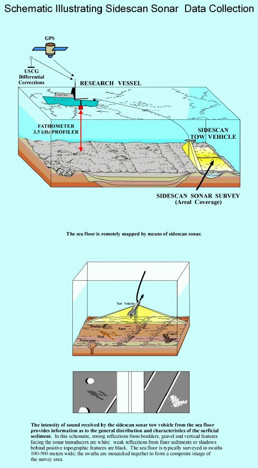
The sidescan sonar mosaic of the sea floor off New London, Connecticut, covers approximately 19.4 km2 (7.5 square miles) at the mouth of the Thames River (fig. 1) from approximately 41015.5' N, 72008' W to 41018.5 N, 72002' W. Data for the image were collected between October 17th and October 19th, 1990 aboard the RV UCONN using a 100-kHz EG&G sidescan sonar unit set for 100-m swaths and towed approximately 3-4 m above the bottom. Navigation was primarily by DelNorte (PINSS input) and Miniranger. This work was funded by the U.S. Minerals Management Service through a Cooperative Agreement with the State Geological and Natural History Survey of Connecticut. Data collection and processing was performed by Shannon Byrne and Eric Halter at the Ocean Mapping Development Center, University of Rhode Island. The mosaic was originally produced at 1:3,479-scale utilizing the U.S.G.S. Mini Image Processing ystem (MIPS) in an Equatorial Mercator Projection. Processing included bottom, ratio, and radiometry corrections; sectioning the survey area; "Geoming" individual map sections; "stenciling" and "mosaicing"; and building the final image. The shading convention for this mosaic is that dark tones are interpreted as fine sediment (fine sand, silt and clay); and light tones are interpreted as coarse sediment. Rough and "grainy" patches are interpreted as glacial drift or bedrock outcrops.
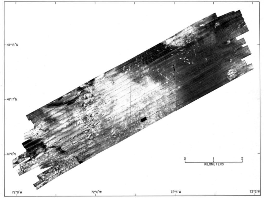
The image files contained here have been modified, using Arc/Info software, from the three original TIFFs delivered by University of Rhode Island. The images were converted to grids, geo-referenced, and individually reclassified in a manner similar to linear stretching to account for variations in gray scales among the three sections of the mosaic. The grids were then converted back to TIFF format with world files in Latitude/Longitude decimal degrees (no projection). Pixel size is approximately 0.8 meters. A preliminary image of the entire survey area is depicted in figure 2. This image was scanned from a photograph.
More complete information about the mosaic and follow-up sampling can be obtained in Poppe and others (1992), Neff and others, (1992) and Zajac (1995) or by contacting the State Geological and Natural History Survey of Connecticut at the Connecticut Department of Environmental Protection, 79 Elm Street, Hartford, CT 06106.
Neff, N. F., Lewis, R. S., McMaster, R. L., and Hyde, R., 1992, Non-energy resources Connecticut and Rhode Island coastal waters: U.S. Department of Interior, Minerals Management Service, Cooperative Agreement No. 14-12-001-30497-CT, Final Report for FY 1989, 28pp.
Poppe, L.J., Lewis, R.S., and Moffett, A.M., 1992, Texture of surficial sediments in northeastern Long Island Sound: US Geological Survey Open-File Report 92-550, 13 p.
Zajac, R. N., 1995, The use of underwater remote sensing methods for the study of benthic habitats and communities at multiple spatial scales in Long Island Sound: Connecticut Department of Environmental Protection, Grant CWF-221-R, Final Report.
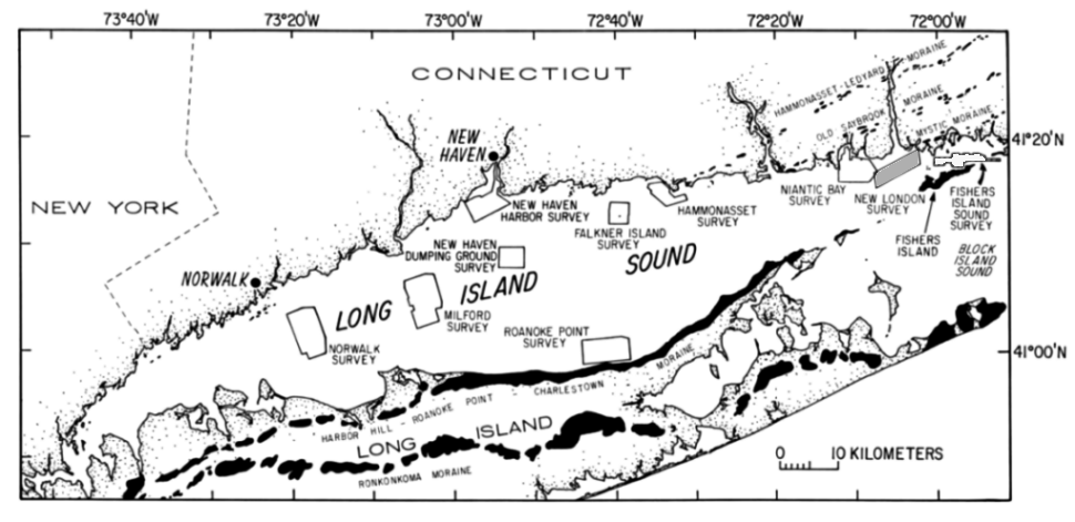
Figure 1. Map showing the location of the New London study area. Also shown are the major onshore moraines, and the locations of other sidescan sonar surveys completed as part of this series.
Figure 2. Preliminary mosaic of the New London survey area.
The sidescan-sonar mosaic is a digital image with a 1-m pixel size ( a pixel represents one meter on the sea floor). The three digital images are available for viewing as graphic files in "tif" format with their associated Arcview geo-reference world files. The three files are: newlo1.tif (21Mbytes) and newlo1.tifw
newlo2.tif (24Mbytes) and newlo2.tifw
newlo3.tif (23Mbytes) and newlo3.tifw
[an error occurred while processing this directive]