CHAPTER 5 - CONTAMINANT DISTRIBUTION AND ACCUMULATION IN SEDIMENTS OF LONG ISLAND SOUND: FIELD WORK AND INITIAL RESULTS
M. R. Buchholtz ten Brink and E. L. Mecray
US Geological Survey, Woods Hole, MA 02543
INTRODUCTIONThe water and sediment quality of many coastal waters in the United States are impacted by proximity to urban centers and by industrial and agricultural activities. Semi-enclosed marine areas, such as Long Island Sound, are particularly sensitive to anthropogenic inputs because their sediments and water may be less efficiently removed, dispersed, and diluted. Long Island Sound (LIS) is bordered by New York City as well as the large cities of Stamford, Bridgeport, Norwalk, New Haven, and New London (CT) and Huntington and Smithtown (NY). In addition, rivers such as the Housatonic, Quinnipiac, Connecticut, Norwalk, and Thames drain extensive inland areas of Connecticut and Massachusetts into the Sound (Zimmerman et al., 1996). The potential for adverse environmental effects (Long et al., 1996 and references therein), plus management concerns (e.g., Robertson et al., 1991), prompted the U.S. Geological Survey to undertake a multidisciplinary study of environmental conditions in the Sound and geologic processes that influence these conditions. Broad objectives of the 5-year program are to: (1) identify and map the extent of sedimentary environments and associated contaminants on the sea floor; (2) understand the processes by which pollutants and waste material interact with and accumulate in sedimentary deposits; (3) improve our knowledge of transport of sedimentary particles and associated pollutants; and (4) increase our understanding of the exchange of pollutants between sediments and the overlying water.
One component of this ongoing study is an assessment of the distribution of selected contaminants in LIS sediments and determination of their mobility and probable fates. This information will provide baselines for contaminants, identify sources, determine transport and dispersal paths, identify areas of extensive contaminant accumulation, and provide a basis for model predictions of burial and remobilization rates. The distributions of Clostridium perfringens, a tracer for sewage input, and other contaminants were measured in surficial sediments collected in 1996 throughout LIS. Further geochemical analysis and radiological dating of sediment cores from the Sound will provide a record of past contaminant loadings and accumulation patterns. A database of contaminated sediment measurements in LIS is also being compiled from the literature and other historical records to supplement the 1996 samples and to provide a tool for research and management use.
This report summarizes information about the sample locations and methodology and also reports initial results of Clostridium perfringens and lead in sediments.
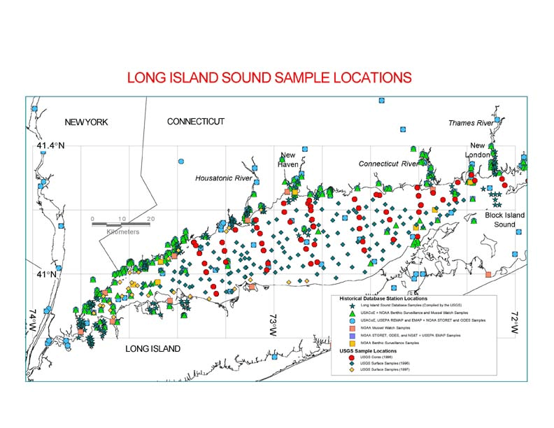
METHODSSediment cores were collected for geochemical analysis in June 1996 at 58 stations along N-S transects (fig 1). Sample sites were selected to include: (1) areas that are representative of particular sedimentary regimes (Knebel et al., 1999 and Chapter 1 in this document); (2) transects away from coastal contaminant sources; (3) regions where sidescan mosaics and biological community data have been generated (Poppe, Chapter 2 in this document and Zajec, Chapter 4 in this document); and (4) sites offshore from land-based sites of study (Varekamp and Scholand, 1996; Varekamp, 1996). Additional grab samples, collected in western LIS during April and June 1996 and in March 1997, provided additional coverage for a total of 219 surface samples.
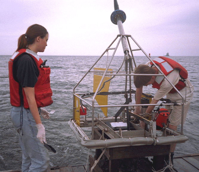
The grab sampler is a modified Van Veen type (Teflon-coated; fig 2) that has a downward looking video- and still-camera attached. Video recordings provided a means of characterizing bottom habitats, the geologic environment, and the quality of the sediment grab prior to sampling. After photographing and describing the sediment collected in the grabs, the overlying water was removed and the upper 2 cm of sediment was skimmed from the grab with a Teflon-coated shovel. Sediment was placed in a pre-cleaned (5% HNO3, distilled water, and methanol rinse) plastic container, homogenized, and aliquots were separated for later analysis of organic and inorganic contaminants, Clostridium perfringens spores, and sediment texture. Sample aliquots were weighed, sealed, and refrigerated until they were analyzed.
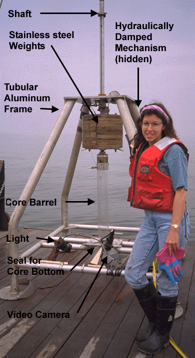
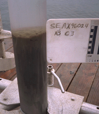
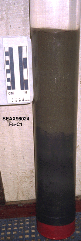
Sediment cores were collected with the USGS hydrostatically-dampened gravity corer (fig 3a, Bothner et al., 1997), which collects 11-cm diameter cores up to 70 cm in length in clear, polycarbonate tubing. The corer is designed to minimize disturbance of the sediment surface so that detailed measurements can be made near the sediment-water interface. The overlying water collected in the corer was usually very clear, and features on the surface, such as fecal pellets, were distinct (fig 3b). The corer can be operated in a piston mode or piston-free mode; both were used in LIS. The piston mode provided slightly longer cores whereas the piston-free mode provided less disturbance of the bottom. A bottom-facing video was mounted on the frame of the corer and focused to record the entry of the corer into the sediment. This allowed the core to be placed in a location that appeared typical for the station. It also avoided placement of the sampling gear in dangerous spots and recorded any leakage that may have occurred from the bottom of the core. On deck, the cores were capped, described, and stored (either refrigerated or frozen) for later sectioning and analysis. Salinity values were determined on a sample of overlying seawater for each station with a hand-held refractometer. The overlying water was left in non-piston cores. Cores recovered with pistons above the sediment had either the piston removed and the core barrel back-filled with a small amount of filtered sea water or the core barrel shortened to just above the water level prior to storage. This prevented movement of the sediment surface due to sloshing inside the full core barrel during transit.
On shore, X-radiographs were taken of all cores (in an upright position) at Falmouth Hospital to document fine-scale lithological features and to aid in selection of cores for sectioning. Cores were kept refrigerated or frozen until sectioning. Immediately prior to sectioning, the overlying water was removed and profiles of magnetic susceptibility, bulk density, and P-wave velocity were determined on each whole core with a Multisensor Core logger (MSCL 17; GEOTEK, Hasselmere Eng.) using methods described in Boyce (1973). Cores were then extruded from the top of the barrel and sectioned in 0.5 cm intervals, with edges trimmed to avoid sample smearing. Sediments were sectioned with spatulas made from titanium to prevent contamination. All surfaces touching the sediment (core barrels, sampling spatulas, aliquot containers) were rinsed with dilute acid (5% HNO3), distilled water, and methanol and were allowed to air-dry prior to use. Each 0.5 cm section was homogenized and a subsample placed into a sterile Whirl-pak bag and refrigerated until it was analyzed for Clostridium perfringens concentrations. The remainder of the sample was weighed and subsequently freeze-dried. Water content was determined by weight loss. Sample analysis is currently underway on the cores for major components (e.g., Al, Ba, Fe, Corg, Mn); anthropogenic contaminants (e.g., Ag, Pb, Cu, Zn, Cd, Hg); selected organic compounds; radioisotopes; grain size; and environmental indicators (e.g., foraminifera and pollen). Eventually, radiochemical and lithological data will allow historical horizons to be identified so that contaminant accumulation rates and mobility can be determined.
Grain size was determined on wet sediments using laboratory methods described in detail by Folk (1974) and Poppe et al (1985). Clostridium perfringens aliquots were kept refrigerated until analysis by membrane filtration and enumeration (U.S. Environmental Protection Agency, 1995). The aliquot for chemical analysis was freeze-dried, and the water content determined by weight loss. A subsample (> 50 mg) was prepared for analysis by total digestion using HNO3, HCl, HClO4, HF, microwave, and H2O2. The solubilized sediment was measured for Fe, Al, Ca, Ti, Mn, Zn, Ni, Cr, V, Cu, Ba, and Zr using a Jobin-Yvon JY24 sequential inductively-coupled plasma optical emission spectrometer (ICP-ES). Cd, Pb, and Ag were measured with a Perkin-Elmer 5100PC graphite-furnace Atomic Adsorption Spectrometer (AAS). Digestion, ICP-ES, and AA analysis followed procedures used by Murray and Leinen (1996).
Analytical results and sample identification information for both grab (Table 1) and core samples have been entered, organized, and reduced using standard spreadsheet and plotting software.
Gamma emitting radioisotopes, including 210Pb and 137Cs, were identified on a low-background PGT (Princeton Gamma Tech) Germanium well detector and used to quantify sediment accumulation rates and the depths of sediment mixing. Only preliminary results for a few cores are available at this time.
Contaminated Sediment Database
A database of contaminated sediment measurements in LIS is also being compiled from historical records and from sources in the literature to supplement the 1996 samples and to provide a tool for research and environmental management use. The database contains: (1) original data on chemical constituents and sample identification from published and gray literature sources; and (2) documentation about the quality of the data. This database differs from earlier reviews of contaminants in LIS (Brownawell et al., 1992) in that it places data in a digital format and comprehensively includes measurements and metadata reported in the literature (see Chapter 7 in this document) and in records of federal and state agencies as well as private industries. The structure and methodology for the LIS Contaminated Sediment Database follows that of the Gulf of Maine Contaminated Sediment Database (Buchholtz ten Brink et al., 1997). As noted by Brownawell et al. (1992), documentation of analytical quality for data is often missing from the literature. After data entry is completed, data quality for the heterogeneous sets will be verified by batch validation techniques, which include review of outlying points and comparison to norms identified in regional studies of NOAA and the USGS (Manheim et al., 1998). Locations of samples entered in the database to date are shown in figure 4. The data include: (1) samples from other databases such as EMAP, ODES, and STORET; (2) data from NOAA’s Benthic Surveillance and Mussel Watch Programs; (3) permit files from SAIC and the US Army Corps of Engineers; (4) data from journal articles; and (5) samples from the USGS studies.
Sediment type and accumulation
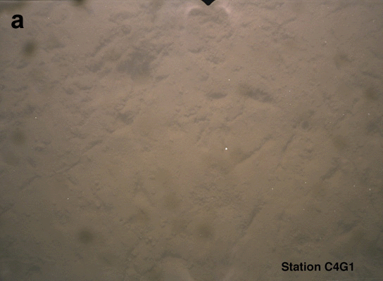
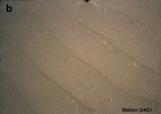
The sedimentary environments for the entire LIS basin have been mapped and outlined by Knebel et al. (1999; Chapter 1 in this document). These data show that LIS sediments are generally muddy in the west with a transition to coarser textures toward the east. Sediments (fig 5a, 5b, 5c) observed on bottom video, and in cores, range from soft, black odorous mud to well-sorted coarse sand. In addition, regions offshore of urban areas appear to have areas of deposition where accumulation rates are enhanced by anthropogenic activity. Preliminary results indicate that the thickness of modern fine-grained sediments tends to be greater at the northernmost stations than at stations farther south along each coring transect.
Clostridium perfringens distribution
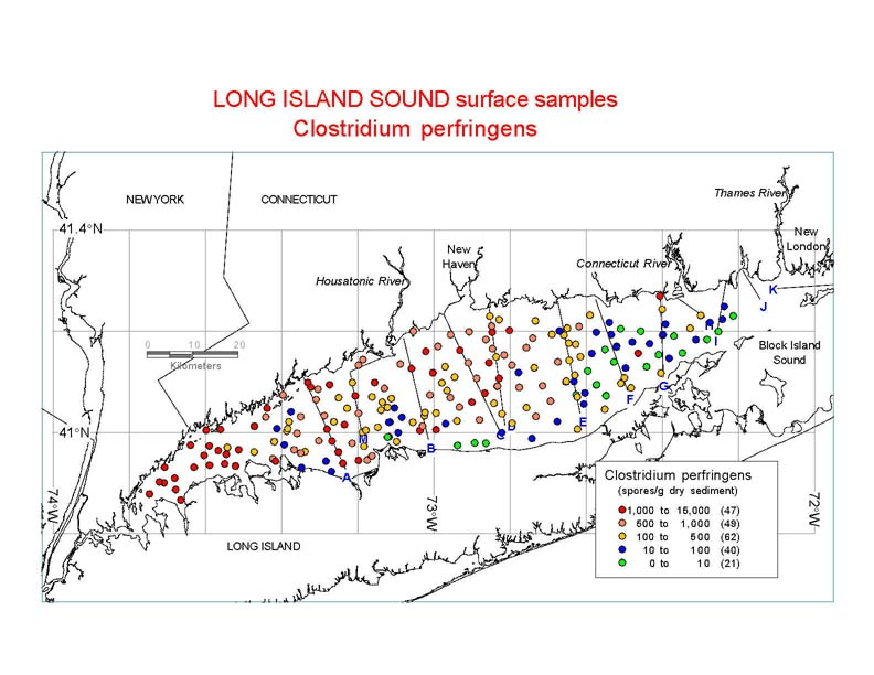
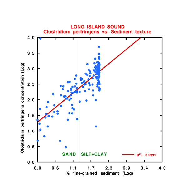
Clostridium perfringens is a bacterium that is naturally present in the intestinal tract of mammals. Its spores are essentially inert in marine sediments and consequently are an excellent tracer of sewage input into an ecosystem. Since sewage in coastal waters is often a major source for other contaminants (e.g., Ag, Cu, and Hg) these bacteria concentrations are a valuable screening tool for the magnitude and distribution of other contaminants in sediments. Clostridium perfringens concentrations measured in surface sediments (figs. 6 and 7a) and core samples indicate widespread and long-term addition of anthropogenic components to the sedimentary system in LIS. Values range from 15,000 to 0 spores/g-dry sediment in 0-2 cm aliquots. Surface sediments typically have the highest Clostridium perfringens concentrations in the western end of the Sound, very low or non-detectable values in the eastern part, and relatively constant values in the central part. This pattern is attributed to two factors. First, the spores are small and are transported along with the fine-grained fraction of sediment (fig. 7b). Spores are winnowed from and do not accumulate with coarser sediments, such as those found in the dynamic eastern part of the Sound. Second, the strong bottom currents especially in the eastern and east-central Sound create an environment in which suspended materials can be widely dispersed and homogenized prior to deposition and burial. The high concentrations in the western Sound may be associated with input from New York City sewage sources that flush into LIS.
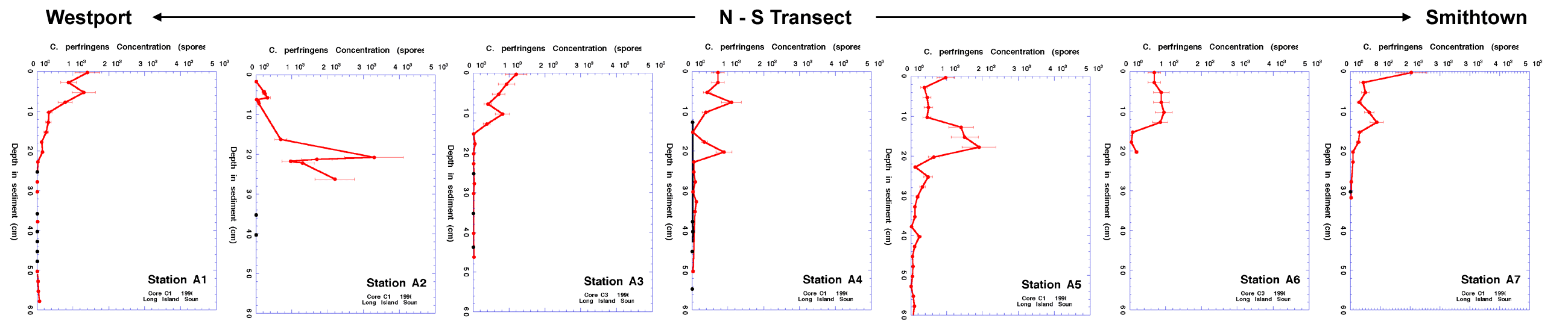
Clostridium perfringens profiles (fig. 8) show concentrations above background levels to depths of approximately 30 cm in all regions; however, the bulk concentrations are much greater in the muddy sediments. Steep gradients in contaminant profiles of the muddier cores, which are located in the depositional regions (fig. 8a), contrast with concentrations that are generally constant with depth in the sandier cores (fig. 8b). Profiles of fallout isotopes (137Cs), naturally occurring isotopes (210Pb), and many metals profiles indicate that mixing depths vary greatly within LIS. Station A1, near Westport, has laminations in x-radiographs of the core, a mixing depth of near one cm, a 210Pb profile indicating a constant accumulation rate over the upper 20 cm of the core, and a clear 137Cs peak at 7 cm (fig. 8a). Age assignments for this core show the onset of a sewage signal in the late 1800’s, with a marked increase of contaminant concentrations in the post WWII period. A transect of Clostridium perfringens profiles from north to south across LIS (fig. 8c) illustrates the complexity that differing degrees of sediment winnowing, mixing, texture, and source proximity can introduce into the sediment record. The uniformity with depth in the sandy profiles observed for both Clostridium perfringens and contaminant metals is consistent with the active reworking of the seafloor that occurs due to bottom currents in the higher-energy environments (Signell et al., 1998; Knebel at al., 1999 and Chapters 1 and 6 in this document).
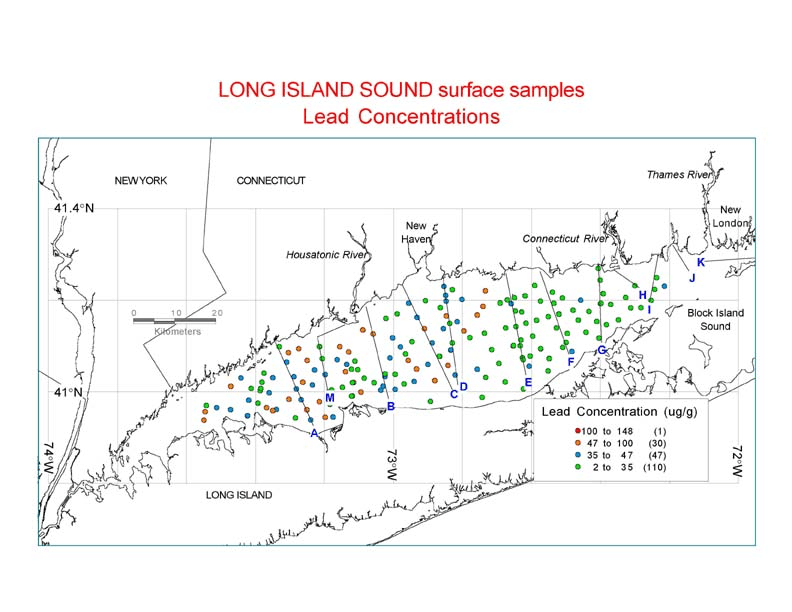
As was found for Clostridium perfringens, high concentrations for many other contaminants follow the distribution of fine-grained sediments (e.g., figure 9 for Pb; Kreulen et al.(1997) for Hg), reflecting the focusing of contaminant-bearing particles in regions of deposition and their removal or non-deposition in other areas. Contaminant concentrations in the surficial sediments are relatively uniform across the study area after normalization to % fines, Fe, Al, or organic carbon, all of which correct for the relative abundance of small particles and contaminants associated with them. The spatial heterogeneity of contaminant concentrations for surface sediments is relatively small within a particular sedimentary environment. Many metals (e.g., Cu, Cr, Zn) co-vary, indicating common sources and transport patterns within the basin. Recent sediments in the western basin typically have concentrations of metals up to three times greater than pre-industrial background values. In most depositional areas, however, the metal concentrations in sediment cores decrease near the surface, reflecting a reduction in contaminant sources during the 1980s and 1990s. Sediment profiles will be used to determine inventories of contaminants in the Sound and constraints for calculations of elemental budgets and fluxes for the region.
Samples from surface grabs and sediment cores are currently being analyzed for many parameters; however, aliquots exist for additional interested collaborators. The data generated will complement existing data on contaminant distributions in LIS and allow a detailed reconstruction of the contaminant and sediment history of the Sound over the last hundred years. The suite of data that is being generated for contaminants will provide a comprehensive regional view of the sources, fate, and transport of these potential toxins in LIS sediments.
Many thanks and much appreciation is given to the numerous people who have contributed to various aspects of this work, and in many cases, continue to do so. Technical assistance in sample analysis and processing was provided by Michael Casso, Peter Gill, Erin Galvin, Shannon McDaniel, and Adila Jamil (Boston University). Rick Rendigs, Emily Banks, Bart Kreulen, Andrew Ouimette, Kathy Hall, Jane Cookman, Earl Young, Rebecca Urbach, Beth Duffy, Adam Goss and Zobeida Cruz-Monserrate also contributed to sample collection and processing. Jamey Reid and Polly Hastings spearhead the database component of this work and its success owes much to the gracious collaboration of colleagues Frank Manheim (USGS), Tom Fredette (US Army Corps of Engineers- New England Division-NED), Peggy Myre Murray (SAIC), Ed Long (NOAA), Matt Liebman (EPA), and Ralph Lewis (LIS Research Center and State of CT). Clostridium Perfringens analysis was done by Kathy Feldman of Biological Analysis Laboratory/Thielsch Engineering, Inc. and X-radiography was done with the generous assistance of the Radiology Department staff at Falmouth Hospital (Bruce Ekholm, Mike Fishbein, JoAnn Smith, and Pat Nolan). The sediment geochemistry represented by this report is a part of an interdisciplinary, multi-institutional study of pollutant and sediment fate and transport in LIS. Our understanding of human impact on the sediment of this embayment would be lessened without the contributions of colleagues Larry Poppe (USGS), Harley Knebel (USGS), Rich Signell (USGS), Jim Latimer and Daryl Keith (both at EPA), Rick Murray (Boston University), and Johan Varekamp (Wesleyan University). Funding for this work is provided by the US Geological Survey Coastal and Marine Program.
REFERENCESBothner, M.H., P.W. Gill, W.S. Boothman, B.B. Taylor, and H.A. Karl, 1997. Chemical and textural characteristics of sediment at an EPA reference site for dredged material on the continental slope SW of the Farallon Islands. U.S Geological Survey Open-File Report No. 97-87.
Boyce, R.E. 1973. Physical Properties-Methods. In: Init. Rep. Deep Sea Drilling Program Vol 15, 1115-1127.
Brownawell, B., N. Fisher, and L. Naeher,1992. Characterization of Data Base on Toxic Chemical Contamination in Long Island Sound. Report to Environmental Protection Agency; Marine Science Research Center, SUNY-Stony Brook. 114 pp.
Buchholtz ten Brink, M.R., F.T. Manheim, P. Hastings, S.H. Jones and L. G. Ward, P. F. Larsen, B. W. Tripp and J. W. Farrington; G. T. Wallace, Jr., 1997. Contaminated-Sediment Database for the Gulf of Maine. In: Proceedings of the Gulf of Maine Ecosystem Dynamics, Regional Association for the Gulf of Maine Report 97-1, p. 283.
Folk, R.L., 1974. The Petrology of Sedimentary Rocks: Hemphill Publishing Co., Austin, 182 pp.
Knebel, H.J., R.P. Signell, R.R. Rendigs, L.J. Poppe, and J.H. List, 1999. Seafloor environments in the Long Island Sound estuarine system: Marine Geology, v. 155, 44 ms pages (in press).
Kreulen, B., J. Lynton, J.C. Varekamp, and M. Buchholtz ten Brink, 1997. Hg pollution in and around Long Island Sound. EOS, Transactions American Geophysical Union, Vol. 78 (46), 1997 Fall Meeting Supplement. pF211.
Long, E.R., A. Robertson, D.A. Wolfe, J.W. Hameedi, and G.M. Sloane, 1996. Estimates of the spatial extent of sediment toxicity in major U.S. estuaries. Environmental Science and Technology, Vol. 30 (12), 3585-3592.
Long, E.R., L.J. Field, and D.D. MacDonald, 1998. Predicting toxicity in marine sediments with numerical sediment quality guidelines. Environmental Toxicology and Chemistry. 17(4): 714-727.
Manheim, F.T., M. Buchholtz ten Brink, and E.L. Mecray, 1998. Recovery and Validation of Historical Sediment Quality Data from Coastal and Estuarine Areas: An Integrated Approach., J. Geochem. Exploration. Special Vol. 7th Int'l Symposium on Envir. Geochemistry. in press..
Murray, R. W. and M. Leinen, 1996. Scavenged excess Al and its relationship to bulk Ti in biogenic sediment from the central equatorial Pacific Ocean. Geochimica et Cosmochimica Acta, 60, 3869-3878.
Poppe, L.J., A.H. Eliason, and J.J. Fredericks, 1985. APSAS - An automated particle size analysis system: U.S. Geological Survey Circular 963, 77 p.
Robertson, A., B.W. Gottholm, D.D. Turgeon, and D.A. Wolfe, 1991. A comparative study of contaminant levels in Long Island Sound. Estuaries 14(3) p.290-298.
Signell, R.P., H.J. Knebel, J.H. List, and A.S. Farris, 1998. Physical Processes Affecting the Sedimentary Environments of Long Island Sound. Proceeding, 5th International Conference on Estuarine and Coastal Modeling, ASCE Press, M. Spaulding and A. Blumberg, Eds.pp 400-412.
U.S. Environmental Protection Agency, 1995. Method for Detection and Enumeration of Clostridium perfringens in Water and Sediments by Membrane Filtration. USEPA Office of Research and Development: Report EPA/600/R 95/030. 14 pp.
Varekamp, J.C., 1996. Metal pollution in wetlands around Long Island Sound. In: Proceedings of the 3d Biennial Long Island Sound Research Conference, 1996, p.94.
Varekamp, J.C. and Scholand, S.J., 1996. Metal pollution in coastal and riverine wetlands. In: Proceedings of the 3d Biennial Long Island Sound Research Conference, p.95-100.
Zimmerman, M.J., S.J. Grady, E.C. Todd Trench, S.M. Flanagan, and M.A. Nielsen, 1996. Water-Quality Assessment of the Connecticut, Housatonic, and Thames River Basin Study Unit: Analysis of Available Data on Nutrients, Suspended Sediments, and Pesticides, 1972-1992. U.S. Geological Survey Water-Resources Investigations Report 95-4203. 162 pp.
Table 1 section A. Sample station, location and Clostridium perfringens data for surface sediments collected in Long Island Sound for chemical analysis. Parameters (column titles) given in section A for each sample are:
Row #
Cruise
Full Length Field Name
Station name
Station also known as:
Longitude (W Decimal degrees as neg)
Latitude (N decimal degrees)
Year sample collected
Date sample collected (Julian date)
Time (GMT) sample collected
Latitude (whole degrees N)
Latitude (decimal minutes N)
Latitude (decimal minutes N)
Latitude (whole degrees N)
Water depth (m) at site
Sample Interval in sediment (cm)
C. perfringens (spores/g wet sediment)
C. perfringens (spores/g wet sediment) qualifier
C. perfringens (spores/g dry sediment)
C. perfringens (spores/g dry sediment) qualifier
C.perf qualifier
Table 1 section B. Grain size data for samples that have both sediment chemistry and sediment texture analyzed are listed for each sample. Grain size data for these samples is listed in the texture database within Chapter 3 of this document also. Parameters (column titles) given in section B are:
Lab ID number for texture analysis (SED LAB #)
Sample ID used by sed lab (Field ID)
gravel (wt%)
sand (wt % )
silt (wt %)
clay (wt %)
Verbal Equivalent of sediment texture
median grain size using Method of Moment Statistics (MOMS)
MOMS mean grain size
MOMS standard deviation of mean grain size
MOMS skewness of grain size distribution
MOMS kurtosis of grain size distribution
Mode 1
Mode 1 Frequency
Mode 2
Mode 2 Frequency
Mode 3
Mode 3 Frequency
Number of Modes
Fraction of sample in 11 phi size range (%)
Cumulative frequency of sample in 11 phi or smaller (%)
Fraction of sample in 10 phi size range (%)
Cumulative frequency of sample in 10 phi or smaller (%)
Fraction of sample in 9 phi size range (%)
Cumulative frequency of sample in 9 phi or smaller (%)
Fraction of sample in 8 phi size range (%)
Cumulative frequency of sample in 8 phi or smaller (%)
Fraction of sample in 7 phi size range (%)
Cumulative frequency of sample in 7 phi or smaller (%)
Fraction of sample in 6 phi size range (%)
Cumulative frequency of sample in 6 phi or smaller (%)
Fraction of sample in 5 phi size range (%)
Cumulative frequency of sample in 5 phi or smaller (%)
Fraction of sample in 4 phi size range (%)
Cumulative frequency of sample in 4 phi or smaller (%)
Fraction of sample in 3 phi size range (%)
Cumulative frequency of sample in 3 phi or smaller (%)
Fraction of sample in 2 phi size range (%)
Cumulative frequency of sample in 2 phi or smaller (%)
Fraction of sample in 1 phi size range (%)
Cumulative frequency of sample in 1 phi or smaller (%)
Fraction of sample in 0 phi size range (%)
Cumulative frequency of sample in 0 phi or smaller (%)
Fraction of sample in -1 phi size range (%)
Cumulative frequency of sample in -1 phi or smaller (%)
Fraction of sample in -2 phi size range (%)
Cumulative frequency of sample in -2 phi or smaller (%)
Fraction of sample in -3 phi size range (%)
Cumulative frequency of sample in -3 phi or smaller (%)
Fraction of sample in -4 phi size range (%)
Cumulative frequency of sample in -4 phi or smaller (%)
Fraction of sample in -5 phi size range (%)
Table 1 section C. Major and trace element data for surface sediments collected in Long Island Sound for chemical analysis. Parameters (column titles) given in section C for each sample are:
Ag (silver) µg/gFigure 1. Locations of sediment cores and grab samples collected by the U.S. Geological Survey in 1996 and 1997 for characterization of contaminant distribution and accumulation, sediment type, and sedimentation rates in Long Island Sound.
Figure 2. Photograph of the modified Van Veen grab sampler used to collect samples from the sediment surface, bottom video, and still photographs of the sea floor.
Figure 3. Photograph of the corer (a) used to collect sediment cores (b) with minimal disturbance of the sediment water interface. A video focused at the base of the corer allowed monitoring of both the sea floor and the coring operation.
Figure 4. Locations of samples reported in the literature that have contaminant data currently entered in the database. The database compilation is ongoing and new collaborations are welcome.
Figure 5. Photographs of bottom sediments: (a) mud in depositional environment; (b) sand in sorting and reworking environment; and (c) subsurface sediment layers suggesting accumulation events.
Figure 6. Dots show the locations of surface (0-2 cm) samples collected in Long Island Sound in 1996-1997 with concentrations of Clostridium perfringens measured in the sediments indicated by color. Clostridium perfringens values are an indication of the relative influence of sewage input to a marine system. Values in Long Island Sound range from near-background detection limit (=10 spores/gram dry sediment) to concentrations ten thousand times greater.
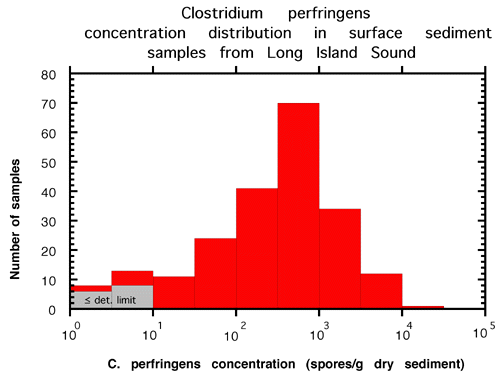
Figure 7. (a) Histogram of Clostridium perfringens analysis in surface sediments indicating that the majority of sediments have significant contamination input from sewage. The mean value for the 200 samples that measured above detection limits is 893 spores/gram dry sediment (median is 475 spores/gram dry sediment). Ten additional points (shown in gray) were below detection limits. (b) Scatter plot showing the correlation (r
2=0.5931) between the concentration of Clostridium perfringens spores and the accumulation of fine-grained sediment.Figure 8. Clostridium perfringens concentration profiles in sediment cores. (a) Depositional environment with radiometric ages applied. (b) Reworking environment. (c) Cores in a N-S transect from Westport to Smithtown.
Figure 9. Dots show the locations of surface (0-2 cm) samples collected in Long Island Sound in 1996-1997 with concentrations of lead measured in the sediments indicated by color. Green indicates values that fall below the naturally-occurring background values in the area, blue indicates slightly elevated lead concentrations, yellow indicates lead concentrations that may induce some toxic response (Long et al. 1998) in organisms exposed to these concentrations, and red indicates sediments for which toxic effects attributable to lead exposure are expected.
[an error occurred while processing this directive]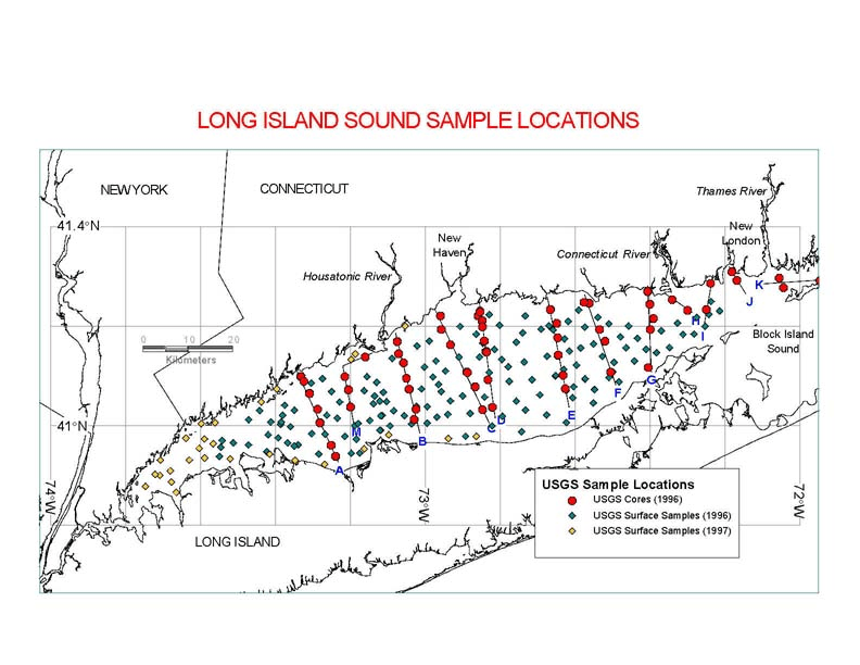