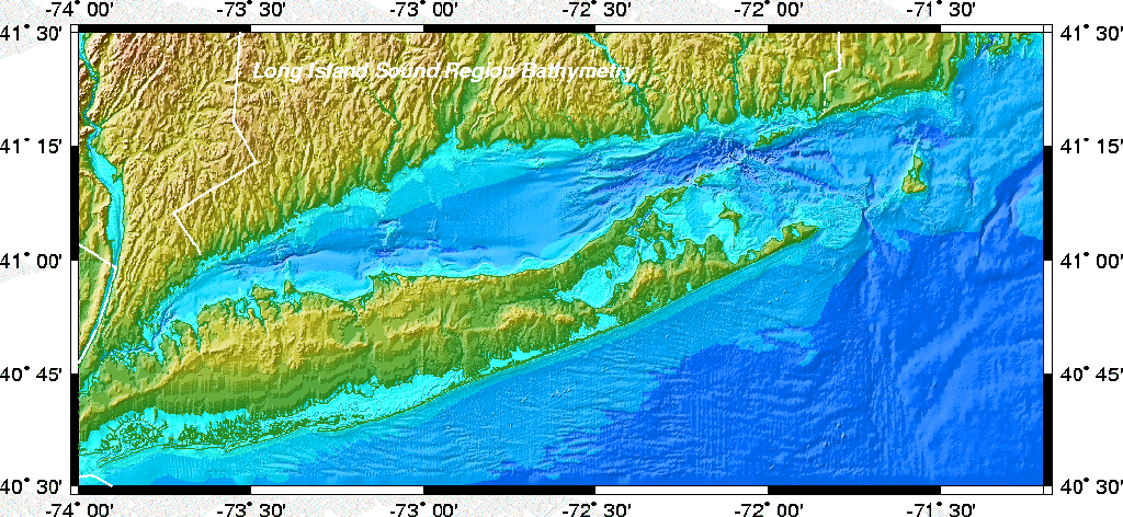
This section describes the construction of the 3-second digital topographic grid of the Long Island sound area. The grid was constructed for use in circulation and wave modeling of the Sound. Data from a variety of sources were combined and outliers were removed. This grid has been used to create additional bathymetric products including contour lines and color shaded images.
Grid Extent:
Longitude: -74 to -71.2
Latitude: 40.5 to 41.5
Horizontal Datum:
NAD83
Vertical Datum:
Land = relative to Mean Sea Level
Bathymetry = relative to Mean Low Water
The data we used for constucting the digital elevation/bathymetry grid came from four different sources:
Much of the above data used NAD27 as the horizontal datum, so we used a utility in the PROJ Map Projection Software called "nad2nad" (with the parameter "conus" specified) to convert the horizontal datum from NAD27 to NAD83. The vertical datum for bathymetry is Mean Low Water.
We used Muriel Grim's digitized smooth sheet data only where there was no digital data from NGDC. Then the last few gaps mostly near the shore were filled in with the Applied Geographics data dumped as points from Arc/Info. Again, we only used the Applied Geographics data only where there was no other data. Before including the Grim and Applied Geographics we checked to see that all three data sets agreed where the boundaries abutted.
Visually scanning all the data together, we removed a few obvious outliers from the NGDC and Applied Geographics data.
We then combined the bathymetry data and land-based DEM data and constructed a 3 arc second digital grid using the freely-available GMT mapping package. Since the land elevations and bathymetry soundings were relative to different vertical datums (water = MLW, land= MSL), we added one meter to the DEM data to approximate a datum shift of the land values from MSL to MLW (the average tidal range is about 0.5-1 m in this region).
We used several GMT scripts to create the grids and images:
do_grd: Creates a grid from the scattered bathy soundings and the DEM land topography. One meter is added to the DEM topography, a blockmedian filter is applied and then the blockmedianed data is gridded using GMT's "surface" routine. The GMT grid produced is li.grd, and is dumped out as ASCII triplets (lon,lat, depth in meters) and gzip compressed into the file li.xyz.gz.
do_intens: Computes gradients of the bathymetry for use in color-shaded relief scripts.
do_image_page: Creates a page sized color shaded
relief map of Long Island Sound. The GZIP PostScript file it creates is about 25 Mb
when uncompressed. It was also converted into several popular image formats:
do_image_poster: Creates a poster sized (26x12) color
shaded relief map of the Sound. The GZIP compressed PostScript file is about 25 Mb when
uncompressed.
do_contours: Creates bathymetric contour lines of the Sound at the following levels: [1:1:10 12:2:50 60:10:100].
[an error occurred while processing this directive]