|
Sidescan-Sonar Imagery of the Shoreface and Inner Continental Shelf, Wrightsville Beach, North Carolina
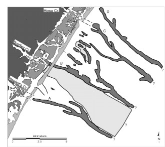
Figure 2. Geologic map of the shoreface and inner shelf off Wrightsville Beach, showing the distribution of Tertiary and Quaternary rocks and sediments based on the seismic and sidescan-sonar data of Thieler (1997). The Oligocene section is ubiquitous, except where it is replaced by Plio-Pleistocene (PPvf) and Quaternary (QPFCF) lithosomes. Note the association of modern tidal creeks with the major paleofluvial channels (labeled A-D and connected by dashed lines). (Modified after Thieler 1997.)
Click on figure to zoom in.
|