|
Multibeam Bathymetric and Backscatter Maps of the Upper Hudso Shelf Valley and Adjacent Shelf, Offshore of New York
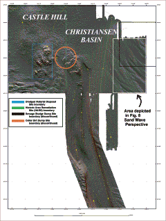
Figure 5. Map showing shaded-relief bathymetry (contoured at 2m intervals) for the northern portion of the survey area. The boundaries of the Dredged Material Disposal Site, the Historic Area Remediation Site, and the discontinued Sewage Sludge and Cellar Dirt Dumpsites are also shown. The image was created by vertically exaggerating the bathymetry (in this case 5 times) and illuminating the relief from 350 (at an elevation of 45). The map shows much small-scale relief and texture to the surficial morphology that is not captured by the 2 m contours. See the text for description of principal features.
Click for larger image.
|