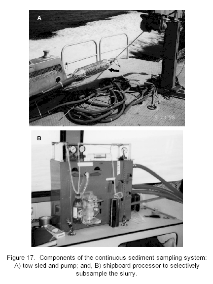
Sediment Sampling Surveys (con't) Underway Surficial Sediment Sampling- Objective and Accomplishments: A method of rapid collection of surficial sediments has been developed by the University of Georgia, Center for Applied Isotope Studies. The system is composed of a towed sled which disturbs the surficial sediments as it drags along the seafloor. The sediment plume in the wake of the sled is sampled by vacuum pump (Figure 17). The sample is transported via a one inch hose to a shipboard processor, which on demand selectively subsamples the fines onto a fiber mesh for analysis by X-ray fluorescence (XRF), which measures for a host of trace elements. A navigational fix (DGPS) and water depth are acquired during each subsample. As long as the sled is on the bottom, the pump is circulating the sediment slurry through the processor and sampling can be continuous. When the towing vessel increases speed, the sled is lifted off the bottom and the system is flushed clear by water from the water column. This method of acquisition allows for the collection of a large number of samples over a large area in a short amount of time. Since the method of analysis preferentially selects the fine grained sediments, results of analysis may be skewed dependent on the relationship between the element being measured and the fine, or clay and silt-size particles.
The underway sediment sampling system was deployed from the vessel G. K. Gilbert in 1996 for a reconnaissance survey of Lake Pontchartrain (Figure 18). Sediment samples were acquired every three-quarter miles in a grid covering the lake. A total of 768 samples were taken in just one week of ship time. The following spring, flood waters from the Mississippi River were diverted through Lake Pontchartrain via the Bonnet-Carre spillway over a months duration. To measure the geochemical impact of the diversion on the surficial sediments in the lake, the underway sediment sampling system was again deployed from the G. K. Gilbert the following summer to revisit each sampling site from the earlier survey. The versatility of this sampling system led to a adjustment in the task objective over the course of the project. The sampling method allows for upper estimate measurements of contaminant distribution in the surficial sediments to be determined for the entire lake in one survey. The initial plan was a reconnaissance grid the first year develop a regional contaminant survey of the lake and to identify hot spots, or areas of high contamination gradients. The initial survey would be followed by higher resolution grid surveys the following years to focus on areas of interest determined by the reconnaissance grid and the other sediment sampling techniques. However, the opening of the spillway the summer of 1996 allowed for the opportunity to measure impact over the lake with a second survey. Future surveys will follow the earlier plan of higher resolution surveys in areas of interest in the lake. The data acquired from the two surveys has been processed and is outlined in detail by Noakes (this volume). The results of the surveys have shown significant shifts in the concentration gradients of the elements measured from the surficial sediments. This finding is corroborated with other analytical techniques, such as Berrylium activity measured from box cores, that indicate that constituents in the lake bottom sediments have undergone transport or dilution between the summers of 1996 and 1997. Further investigation is necessary to determine the impact of the spillway opening on the concentration gradient of the elements measured. The trace metal measurements have been compared by Manheim, et al. (this volume), with measurements determined by other sediment acquisition techniques, mainly grab samples, to determine validity of measurement.
Method: The components of the CS3 towed sled are configured in a cylindrical housing approximately 1.2 m in length and 28 cm in diameter. Umbilical connectors include a tow cable, a power cable, and sediment slurry transport hose. The sled is towed along the seafloor surface, perturbating the sediments in its path to a depth of approximately 4-6 cm and forming a plume from which sediments are sampled. The CS3 submersible pump, made of Delrin (R) plastic, delivers a continuous stream of surface sediments to the survey vessel via a rubber transport hose. The sediment slurry passes unobstructed through a sample processor consisting entirely of plastic and rubber parts, first flowing through a centrifugal cone where the fine sediment fraction (<200 microns) is selectively separated for sample analysis. Samples are collected on demand at intervals determined by the requirements of the survey. At the recommended towing speed of three knots, a maximum collection of approximately three samples per km is possible. For sample collection, the continuously flowing fine fraction slurry is diverted to a collection chamber, where it is dewatered by vacuum filtration and deposited onto a quartz fiber wafer. Samples are keyed to time and location and air dried. Non-destructive elemental analyses for up to 8 selected major and trace elements can be performed simultaneously aboard ship using a wavelength-dispersive x-ray fluorescence spectrometer (XRF), or samples may be returned to the laboratory for a broader spectrum of analyses using an energy-dispersive XRF instrument. Other CS3 shipboard components include a differential Global Positioning System (DGPS) navigational system, portable computer, fathometer, printer, and plotter. Custom software compares information from the fathometer and DGPS each time a CS3 sample is collected. The data, along with the results of XRF analyses, are used to generate two- and three-dimensional profiles of bathymetry and elemental concentrations.
|
|||||||||||||||||