| Scale: |
Representative Fraction
- A representative fraction may be written 1: 500,000.
- The numerator is always 1 and represents a unit of distance on the map.
- The denominator is a greater number than the numerator and represents units of distance on the ground.
- Units of distance represented in numerator and denominator are always the same units, i.e. miles or kilometers.
- In a small scale map, features are small and generalized.
- In a large scale map, features are more detailed but less area is seen.
| Graphic Scale: |
- The graphic scale is a symbol which appears as a small ruler printed on the margin of the map.
- The scale is divided into increments; starting with 0 or 1. Each increment
will indicate the unit in miles, yards, or kilometers.
- Each increment may be divided into smaller increments in order to give a more accurate reading.
- Map scales are usually in miles or kilometers.

Graphic Scale
To measure actual distances
on the ground from information given on a map:
- Use a ruler, protractor, or piece of string to measure the distance between two points on the map;
- Take a reading of that distance on the map scale at the bottom of the map to figure out the actual distance.
| Legend: |
Information in the legend will vary with the map. All road maps will include some of the following symbols or information:
| highways, roads, trails | |
| railroad, bridges, tunnels | |
| population symbols | |
| distance between towns and junctions | |
| total miles between cities | |
| wildlife areas, game refuges, national forests and parks | |
| state parks, campsites, recreational areas, boat launches | |
| state capitol | |
| tourist areas | |
| state, county, national boundary | |
| land types, such as marsh, swamp, etc. | |
| other points of interest |
| Symbols: |
Maps may use a number of other icons as symbols, such as dots in different sizes to indicate population size of cities. Check your road map for notations of symbols and their designation.
| Contour Lines: |
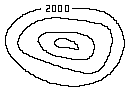 On topographic maps elevation is indicated by contour lines. The contourline system is the use of imaginary horizontal planes cutting through the vertical features of the earth's surface. Imagine that we had an exact model of the state of Louisiana, one that we could look at from every angle. If we decided to cut horizontally into it at regular intervals from the highest point we could then look at each section and transfer that information to a topographic map. Each contour line closes on itself and represents lines of equal elevation.
| Contour Interval: |
This information is given on the topographic map itself. Each vertical interval is the same, i.e. 50 feet or 5 meters. These vertical intervals are much like the rise of a step, one above each other. All contour intervals start with sea level as 0. As the contour interval number increases the terrain is more elevated. Contour lines which are close together indicate steep slopes. Contour lines which are far apart indicate gentle slopes. Check the bottom of the map for contour line interval.
[an error occurred while processing this directive]