ObjectivesIntroductionRivers of the Basin HeadlinesAnatomy of a RiverProtecting RiversTreasured TangipahoaActivities |
|---|
Rollin' Down the River:
Riverine Systems
Objectives:
- List four characteristics of a riverine system.
- Define the riparian zone.
- Identify three measurements for use in assessing water quality.
- Describe a process that changes water quality.
Multiple Intelligences Learning Activities:
Verbal/Linguistic: - Obtain information about a river using printed media.
Write a newspaper article using a story grid.
Formulate questions about a problem using Bloom's Taxonomy of Questions.
Interpersonal: - Examine a situation using a PNI (Positive, Negative, Interesting) chart.
Compete in a Tangipahoa River Trivia game using questions formulated from Bloom's Taxonomy.
- Obtain information about a river using printed media.
Introduction
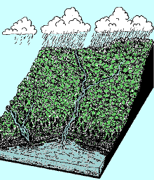
Flowing into, out of, and through the Lake Pontchartrain Basin are rivers which provide water for habitat, bring nutrients, take away waste products and provide areas of scenic beauty and recreation. Some of the major rivers are the Tangipahoa River, Tchefuncte River, Tickfaw River, Amite River, Bogue Falaya River and Lacombe Bayou.
Rivers of the Pontchartrain Basin
HEADLINES
Process:
- Have students read the headlines about rivers in the Lake Pontchartrain Basin.
- Ask students to identify what the headline is about; this is the issue.
- Ask students to choose a river in the Lake Pontchartrain Basin that has some signifiance to them. They may have boated on it, riven over it or lived on or near it.
- Ask different students to share their personal experiences about any of the rivers in the basin.
- Have students research the river they selected. Sources of information include:
- School or local library
- Internet
- Lake Pontchartrain Basin Foundation
- The Times-Picayune or other local newspapers
- La. Department of Environmental Quality (DEQ)
- La. Department of Natural Resources (DNR)
- La. Department of Health and Hospitals
- Make a large class size map of the Lake Pontchartrain Basin with its rivers and attach headlines or articles of interest to the associated rivers located in the Lake Pontchartrain Basin.
Anatomy of a River
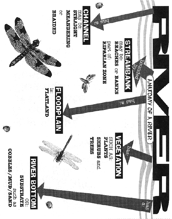
Click the illustraion for a larger view.
Channel:
The channel is the area of a river or stream which periodically or continually contains moving water. Stream channels may have one of several shapes:
- Straight (has a fairly uncurved line)
- Meandering (has loops and curves)
- Braided (looks like strands of water that have been braided)
Stream Channel Shapes

Streambanks:
Streambanks are the portions of the stream which restrict lateral movement of water. Streambanks may be:
- Sandy Beaches
- Mud Banks
- Subject to erosion due to:
- swift moving currents along the cutbank of the river;
- loss of vegetation due to building or change of land use.
Streambanks are part of the Riparian Zone or the vegetated area adjacent to a waterbody, stream or river. A Riparian Zone is important to the health of the river or stream because it:
- Serves to filter runoff from the land before it drains to the river; these filtered materials, may be soils, vegetation or organisms suspended in the runoff;
- Slows down the velocity or speed of the water flowing into the river, thus decreasing erosion;
- Supplies vital habitat for aquatic and semi-aquatic animals;
- Holds the streambank soils together, preventing erosion.
Floodplains:
Floodplains are the flat areas of land covered by materials deposited by the river when it floods. These materials or sediments may be sands, silts, clays, as well as organic material. These areas:
- Contain nutrient rich soils;
- Are located near a source of usable water;
- Are flat lands available for agricultural use;
- May contain valuable wetlands;
- Usually flood when the river overflows its banks during periods of flooding; this fact alone may be an important consideration in choosing to build in a floodplain.
Vegetation:
The variety of plants, woody shrubs and trees along the banks of the channel and in the flood plain are called streamside vegetation. This vegetation is important because:
- It is home to many different kinds of animals;
- It forms a buffer between the forested lands, pasture lands or more developed areas and the channel of the river or stream;
- It serves to stop erosion along the banks of the stream since tree roots hold soil together.
River Bottom or Substrate:
A river or stream bottom may be composed of rock, gravel, cobbles, sand, or mud substrates.
Rock, gravel, or cobbles:
- Provide a hard substrate;
- Provide a place for aquatic plants and animals to live;
- Form riffles where water running over the rock surface becomes well oxygenated.
Sandy and muddy bottoms:
- Are found when the river or stream is slow-moving;
- Occurs because the low velocity of the stream is not enough to transport larger sediments such as rocks and cobbles;
- Are a habitat for burrowing animals.
Protecting Rivers:
The Clean Water Act of 1972 provides that the surface waters of the country be restored and maintained to biological, chemical and physical integrity. The integrity is judged by biological, chemical and physical parameters.
Chemical Parameters include measuring:
- Dissolved minerals picked up from the substrate;
- Any contaminants such as volatile organics, radioactive materials, heavy metals, or toxic chemicals;
- Dissolved oxygen which is necessary for aquatic organisms for respiration and other processes;
- BOD or biochemical oxygen demand or aerobic decomposition; for example, a high degree of decomposition gives a stream a high BOD because it needs a lot of oxygen to break down the organic components found there;
- pH, the measure of the hydrogen ion in water, which makes it either acidic or alkaline;
- Hardness, a measure of magnesium or calcium found in the water. For example, we often notice this when showering: soap and water either lathers easily (soft water) or lathers with difficulty (hard water);
- Phosphates and nitrates, plant nutrients which are introduced into the water from run-off. Fertilizers from farms and detergents cause excessive plant and algae growth.
Physical Parameters include measuring:
- Temperature, which is important to many fish species and provides an optimum climate for metabolic processes, activity and reproduction. The temperature of water affects its chemical concentrations. For example, cold water holds more dissolved oxygen than does warm water;
- Turbidity, a measure of the clarity of water. Turbidity is important because clear water allows photosynthesis to take place at a greater depth;
- The color of water, indicating the presence of dissolved substances and suspended material which affect such processes as photosynthesis;

- Pathogens, disease causing organisms, which may be present, such as, Escherichae coli found in the intestines of warm-blooded animals. UH OH--->
Water Quality is changed by such things as:
- Sediment, e.g., development along river banks causing heavy sediment deposits into the river or stream;
- Dumping of wastes, either hazardous or non-hazardous materials, e.g., pesticides, paint from boat yards;
- Agricultural wastes, e.g., manure from dairy feed lots washing into streams.
Treasured Tangipahoa
The Tangipahoa River begins as an upland stream in Mississippi and flows southeastward from the Mississippi-Louisiana state line through Tangipahoa Parish into Lake Pontchartrain. As it makes its way southward it flows through rolling hills where it has a sand and gravel substrate. South of Highway 190 the characteristics of the river change to those of a lowland stream where flat land levels off and the water becomes sluggish, curvy, and often muddy. The Tangipahoa is listed in Louisiana as a Wild and Scenic Stream. It was used for boating, tubing and swimming, as well as fishing. Since 1987 it has been closed to primary contact recreation (tubing and swimming) due to high bacteria levels.
The Tangipahoa River and the lands which surround it were heavily impacted by land use changes such as timber harvesting or clearing for pasture, subdivisions and roads. This land use change contributed to erosion and increased sedimentation in the drainage basin of the Tangipahoa River.
The Tangipahoa River channel:
- Is straight in the upland stream area as it flows south to Hwy. 190, with a sand and gravel substrate;
- Becomes a lowland stream with a muddy substrate south of Hwy 190.
The streambank:
- Has bluffs, in the upland areas, in which the land lies high above the high water of the river;
- Has sandy beaches or gravel areas in streamside deposits;
- Has cypress swamps near the point at which the stream enters Lake Pontchartrain;
- Has lush vegetation, either forest or swampy wetland, lining other areas of the streambank.
The floodplain:
- Is composed of pine forest and pasture lands in the upland area;
- Consists of cypress and tupelo swamp in the lowland where the stream widens.
Activities: |
©1998 Lake Pontchartrain Basin Foundation
Lessons on the Lake is published by the
Lake Pontchartrain Basin Foundation
Metairie, LA