OBLIQUE AERIAL PHOTOGRAPHS OF SPOR MOUNTAIN,
THE DELL, AND THE THOMAS RANGE, TAKEN IN 1978
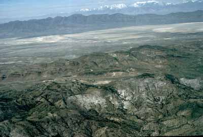
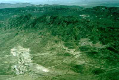 SLIDE 2 shows the view looking northeast at
Spor Mountain (center of photo) and the principal area of beryllium
mining. Open pits shown are the Roadside (lower left), Rainbow
(lower right from center), and Blue Chalk beryllium mines (right
of center). All three mines are in the beryllium tuff member of
the Miocene Spor Mountain Formation. The open cuts to the right
of the Blue Chalk are fluorspar prospects in a rhyolite dome.
SLIDE 2 shows the view looking northeast at
Spor Mountain (center of photo) and the principal area of beryllium
mining. Open pits shown are the Roadside (lower left), Rainbow
(lower right from center), and Blue Chalk beryllium mines (right
of center). All three mines are in the beryllium tuff member of
the Miocene Spor Mountain Formation. The open cuts to the right
of the Blue Chalk are fluorspar prospects in a rhyolite dome.
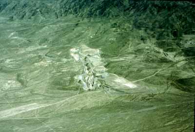 SLIDE 3 looks directly north into the Roadside
beryllium mine.
SLIDE 3 looks directly north into the Roadside
beryllium mine.
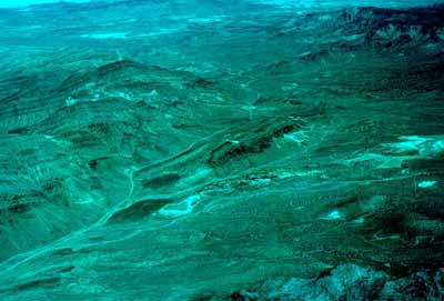 SLIDE 4 shows the view looking northwest over
The Dell at Spor Mountain. The photo shows fluorspar mines on
Spor Mountain (left center), Eagle Rock Ridge (center, dark ridge),
and Yellow Chief uranium mine (right). The open cut on the east
side of Eagle Rock Ridge is the Claybank beryllium prospect; the
circular open cut below and to the left (south) of Eagle Rock
Ridge is the Hogsback beryllium prospect. Both prospects, as well
as the Yellow Chief mine, are in fault-bounded remnants of the
beryllium tuff member of the Miocene Spor Mountain Formation.
A basin-range normal fault extends along the east side of Eagle
Rock Ridge, separating Paleozoic carbonate rocks on the ridge
from Tertiary volcanic rocks east of the ridge.
SLIDE 4 shows the view looking northwest over
The Dell at Spor Mountain. The photo shows fluorspar mines on
Spor Mountain (left center), Eagle Rock Ridge (center, dark ridge),
and Yellow Chief uranium mine (right). The open cut on the east
side of Eagle Rock Ridge is the Claybank beryllium prospect; the
circular open cut below and to the left (south) of Eagle Rock
Ridge is the Hogsback beryllium prospect. Both prospects, as well
as the Yellow Chief mine, are in fault-bounded remnants of the
beryllium tuff member of the Miocene Spor Mountain Formation.
A basin-range normal fault extends along the east side of Eagle
Rock Ridge, separating Paleozoic carbonate rocks on the ridge
from Tertiary volcanic rocks east of the ridge.
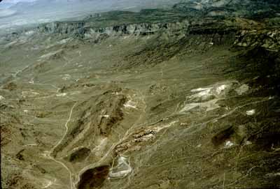 SLIDE 5 shows the northern part of the Dell
and a closer view of Eagle Rock Ridge (left center) and the Yellow
Chief uranium mine (right center) than the previous photo. Beryllium
prospects visible include the Claybank (right side of Eagle Rock
Ridge) and the Hogsback (circular scar, lower part of photo).
The dark exposures to the left (west) of the Hogsback are Eocene
Drum Mountains Rhyodacite, a pre-caldera flow complex. The sequence
(from top to bottom) of rhyolite flows, vitrophyre, and tuff of
the Topaz Mountain Rhyolite is clearly visible in the cliffs at
the top of the photo. The Topaz Mountain Rhyolite lies unconformably
on the Oligocene Dell Tuff, an intracaldera ash flow of the Thomas
caldera. The view is north from a point above the southern part
of The Dell.
SLIDE 5 shows the northern part of the Dell
and a closer view of Eagle Rock Ridge (left center) and the Yellow
Chief uranium mine (right center) than the previous photo. Beryllium
prospects visible include the Claybank (right side of Eagle Rock
Ridge) and the Hogsback (circular scar, lower part of photo).
The dark exposures to the left (west) of the Hogsback are Eocene
Drum Mountains Rhyodacite, a pre-caldera flow complex. The sequence
(from top to bottom) of rhyolite flows, vitrophyre, and tuff of
the Topaz Mountain Rhyolite is clearly visible in the cliffs at
the top of the photo. The Topaz Mountain Rhyolite lies unconformably
on the Oligocene Dell Tuff, an intracaldera ash flow of the Thomas
caldera. The view is north from a point above the southern part
of The Dell.
 SLIDE 6 is a near-vertical view of the Yellow
Chief uranium mine, looking slightly northeast. The north end
of Eagle Rock Ridge appears in the lower left. The outcrops north
of (above) the ridge are Oligocene Dell Tuff. Cliffs in the upper
part of the photo are Topaz Mountain Rhyolite, which lies unconformably
on Dell Tuff here.
SLIDE 6 is a near-vertical view of the Yellow
Chief uranium mine, looking slightly northeast. The north end
of Eagle Rock Ridge appears in the lower left. The outcrops north
of (above) the ridge are Oligocene Dell Tuff. Cliffs in the upper
part of the photo are Topaz Mountain Rhyolite, which lies unconformably
on Dell Tuff here.
 SLIDE 7 shows Fish Springs Flat and the Fish
Springs Range (middle distance), west of Spor Mountain (center),
and the Thomas Range (foreground). The snow-capped peaks on the
horizon are in the Deep Creek Mountains. The Dell is barely visible
below the dark ridge running across the center of the photo (Eagle
Rock Ridge); the Claybank beryllium prospect is visible on the
side of the ridge. The view is to the west from a point above
the Thomas Range.
SLIDE 7 shows Fish Springs Flat and the Fish
Springs Range (middle distance), west of Spor Mountain (center),
and the Thomas Range (foreground). The snow-capped peaks on the
horizon are in the Deep Creek Mountains. The Dell is barely visible
below the dark ridge running across the center of the photo (Eagle
Rock Ridge); the Claybank beryllium prospect is visible on the
side of the ridge. The view is to the west from a point above
the Thomas Range.
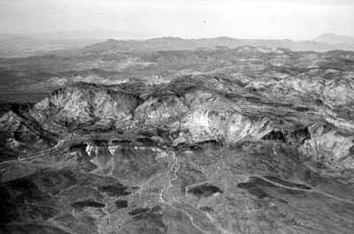 SLIDE 8 is a black and white photo of the
entire Thomas Range. The central part of the range is a dissected
plateau of coalescing flows of Miocene Topaz
Mountain Rhyolite (SLIDES 26-34). The stratigraphy of an individual
eruptive sequence of rhyolite is visible on the south side of
Topaz Mountain (center of photo). From bottom to top, stratigraphic
units are rhyolite flows, dark vitrophyre at the base of the flows,
and light-colored bedded tuff. South of Topaz Mountain, the Topaz
Mountain Rhyolite unconformably overlies faulted older volcanic
rocks and Paleozoic rocks. The view is to the north from a point
above the northern Drum Mountains.
SLIDE 8 is a black and white photo of the
entire Thomas Range. The central part of the range is a dissected
plateau of coalescing flows of Miocene Topaz
Mountain Rhyolite (SLIDES 26-34). The stratigraphy of an individual
eruptive sequence of rhyolite is visible on the south side of
Topaz Mountain (center of photo). From bottom to top, stratigraphic
units are rhyolite flows, dark vitrophyre at the base of the flows,
and light-colored bedded tuff. South of Topaz Mountain, the Topaz
Mountain Rhyolite unconformably overlies faulted older volcanic
rocks and Paleozoic rocks. The view is to the north from a point
above the northern Drum Mountains.
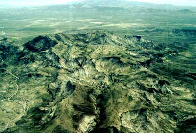 SLIDE 9 shows the great accumulation of Topaz
Mountain Rhyolite flows in the northern part of the Thomas Range.
The eastern part of The Dell is in the lower left. The Dugway
Range is on the horizon. The Pony Express Road runs through the
pass between the two ranges. The view is to the north from a point
above Topaz Mountain.
SLIDE 9 shows the great accumulation of Topaz
Mountain Rhyolite flows in the northern part of the Thomas Range.
The eastern part of The Dell is in the lower left. The Dugway
Range is on the horizon. The Pony Express Road runs through the
pass between the two ranges. The view is to the north from a point
above Topaz Mountain.