
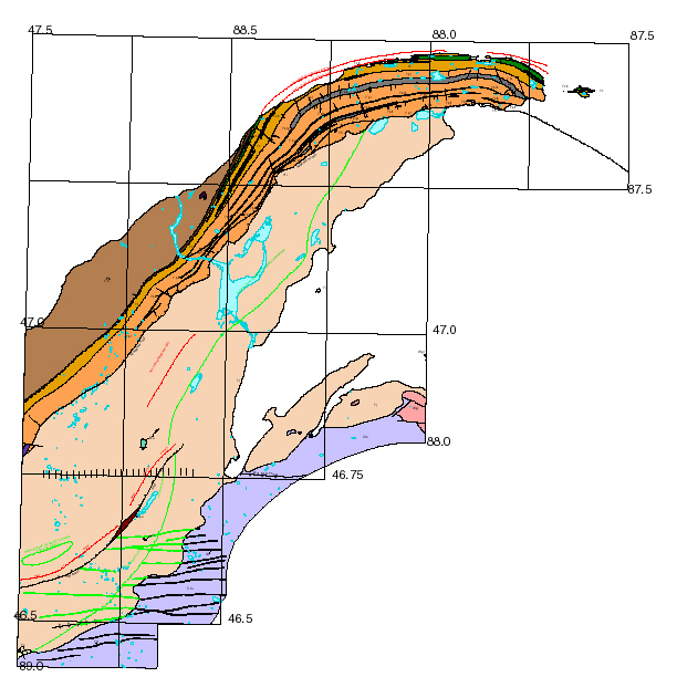
Geology and Mineral Deposits of the Keweenaw Peninsula and Vicinity, Michigan
By William F. Cannon, Michele E. McRae, and Suzanne W. Nicholson
1999
View PDF version of this map [192 KB]

The data in this Open-File report consist of geographic information coverages and tabular data on the geology, structure, mines and mineral deposits of the Keweenaw Peninsula and vicinity, Michigan. The GIS data were originally developed using the ESRI ARC/INFO version 7.1.2 software. These data were then used to create an ArcView 3.1 project file depicting the coverage data and cross sections. The data are structured and attributed so that users can easily query and modify maps and create a variety of derivative maps based on such features as lithology, age, tectonic setting, and stratigraphy. An ArcView project with associated data files is provided for viewing and querying of the map. Also provided are .e00 files if further manipulation of the map is desired.
Download the compressed ArcView project and coverages: Keweenaw.zip [3.23 Mb]
Download the compressed .e00 files: e00 files.zip [2.96 Mb]
Read the metadata
Eastern Mineral Resources
 USGS Home Page
USGS Geologic Information
USGS Home Page
USGS Geologic Information
 USGS Help Page
For Additional Information Contact: Connie Dicken
USGS Geologic Division, Eastern Mineral Resources
703-648-6399
12201 Sunrise Valley Drive, MS 954
Reston, VA   20192
This page is https://pubs.usgs.gov/openfile/of99-149/
Maintained by Eastern Publications Group
Last modified: 20 March 2000