
By Susan M. Karl1, Peter J. Haeussler1, and Anne McCafferty2
U.S. Geological Survey Open-File Report 99-168
Version 1.0
1999
This geologic map updates the geologic maps of the same area published by David A. Brew at 1:63,360 (Brew, 1997a-m; Brew and Koch, 1997). This update is based on 3 weeks of field work, new fossil collections, and the geophysical maps released by the State of Alaska ( DGGS, Staff, and others, 1997a-o). Geologic data from outcrops, fossil ages, radiometric ages, and geochemical signatures were used to identify lithostratigraphic units. Where exposure is poor, geophysical characteristics were used to help control the boundaries of these units. No unit boundaries were drawn based on geophysics alone. The 7200 Hertz resistivity maps (DGGS, Staff, and others, 1997k-o) were particularly helpful for controlling unit boundaries, because different stratigraphic units have distinctive characteristic conductive signatures (Karl and others, 1998). Increased knowledge of unit ages, unit structure, and unit distribution, led to improved understanding of the nature of unit contacts. Northwest- to southwest-directed thrust faults, particularly on Kupreanof Island, are new discovery. Truncated faults and map patterns suggest there were at least 2 generations of thrusting, and that the thrust faults have been folded. Subsequent right-lateral strike-slip NW-SE faults, have offset thrust faults, and these in turn are offset by N-S right-lateral strike-slip faults. Our fieldwork raised as many questions as it answered, and we see this map as a progress report at a reconnaissance level. The main contributions of this map are 1) the greater distribution of Triassic rocks, 2) increased fossil age information, and 3) the identification of thrust faults within and between units.
The Devonian rocks on Kupreanof Island are stratigraphically overlain by Mississippian to Permian gray and green siliceous phyllite, metachert, fossiliferous metalimestone, silicified limestone, metagraywacke, polymictic, matrix-supported metaconglomerate, and minor amounts of greenstone of the Cannery Formation, and Permian limestones and dolostones of the Pybus Formation. These rocks are recrystallized and have a slaty cleavage, but retain relict sedimentary features and minerals. The Cannery and Pybus Formation rocks on Kupreanof Island closely resemble Cannery and Pybus formation rocks on Admiralty Island (Mufler, 1967), where the units were defined (Loney, 1964). On Prince of Wales Island, the Mississippian Peratrovich Formation consists of bedded chert and limestone, the Permian Ladrones Formation consists of fossiliferous limestone with chert nodules, and the Permian Klawak Formation consists of sandstone and siltstone with minor limestone and chert pebble conglomerate (Eberlein and Churkin, 1970; Eberlein and others, 1983). The units on all three islands contain chert and turbidites, indicating slightly deeper water depositional facies than the Devonian rocks. If the islands were geographically distinct in the Devonian, apparently Kupreanof and Admiralty Islands were in depositional communication during the Mississippian and Permian.
The Paleozoic rocks in the map area are unconformably overlain by Middle to Upper Triassic volcanic and sedimentary rocks of the Hyd Group. The sedimentary rocks include shallow to moderately deep-water deposits of carbonaceous subphyllite, calcareous subphyllite, matrix-supported conglomerates, breccias, and debris flows, turbiditic volcaniclastic wackes, and thin-bedded limestone and argillaceous limestone. The conglomerates vary considerably in composition, and reflect local depositional substrate. The volcanic rocks include pillow basalts, pillow breccia, coarse- to fine-grained volcaniclastic deposits, and mafic to felsic tuff. Trace element chemistry of Hyd Group basalts ranges from flat to LREE enriched at 100x chondrite (Newberry and Brew, 1997; Taylor and others, 1995; Karl, unpublished data) and interpretations range from rift to arc tectonic settings for these rocks. The Hyd Group Triassic rhyolites on Annette Island are silicic, peraluminous, and have trace element signatures that match within plate granites (Karl, 1993b). The Hyd basalts on Annette Island have high Nb contents and trace element ratios that are characteristic of marginal basin settings (Karl, unpublished data). Hyd basalts on Admiralty Island have similarly high Nb contents, suggesting they are not subduction-related (Ford and Brew, 1993). Newberry and Brew (1997) conclude the trace element chemistry of the Triassic mafic volcanic rocks at Greens Creek mine, on Admiralty Island, and on Woewodski Island best supports an immature volcanic arc. Taylor and others (1995) conclude the igneous geochemical signatures of the Hyd Group volcanic rocks in southeastern Alaska are permissive of a back arc or intra-arc setting. Rapid sedimentary facies changes, locally controlled conglomerate compositions that directly reflect basement compositions, and carbonaceous restricted basin lithologies support the interpretation of small, structurally controlled basins, such as in a horst and graben extensional setting (Gehrels and Saleeby, 1987a; Karl, 1993a). The variety of igneous geochemical signatures could reflect a rifted arc tectonic environment (Karl, 1993b ). Alternatively, the variety of chemical signatures could be locally influenced by differences in underlying Alexander terrane basement; Gill (1981) suggests volcanic signatures can be modified by assimilation of basement rocks. The Triassic Hyd Group rocks are locally mineralized, have a distinctive Ba-Pb-Zn-Ag chemical signature throughout southeastern Alaska, and host numerous volcanogenic massive sulfide mineral deposits (Berg and Grybeck, 1980; Berg, 1981), including the Greens Creek mine on Admiralty Island. The Triassic rocks have a pervasive fabric and are recrystallized but retain primary mineralogy. Their lower metamorphic grade relative to the Paleozoic rocks supports a regional pre-Mesozoic metamorphic event, as has been documented and dated on Admiralty Island (Karl and others, 1998; in press). The Hyd Group rocks are located along the eastern margin of the Alexander terrane and are depositional on the Alexander terrane. They are distinguished from Triassic rocks of the same age on the western side of the Alexander terrane, which are assigned to the Wrangellia terrane, by three characteristics: 1) the Hyd Group lacks the distinctive stratigraphy of Wrangellia that consists of a kilometers thick basalt section overlain by hundreds to thousands of meters of limestone (Jones and others, 1977), 2) the Hyd group rocks host characteristic Ba-Pb-Zn-Ag volcanogenic massive sulfide deposits that have not been recognized in the Wrangellian rocks, and 3) the Hyd Group basalts have flat to LREE enriched to 100x chondrite trace element signatures that contrast with Wrangellian basalts, which have flatter, less than 50x chondrite, LREE signatures (Davis and Plafker, 1985; Barker and others, 1989).
A regional unconformity separates the Triassic Hyd Group rocks from the Jura-Cretaceous Seymour Canal Formation of the Stephens Passage Group rocks in southeastern Alaska (Brew and Karl, 1988). The Stephens Passage Group is a component of the Gravina-Nutzotin belt, which depositionally overlaps the eastern margin of the Alexander terrane from Gravina Island to the Nutzotin Mountains (Berg and others, 1972). In the map area, the Seymour Canal Formation consists dominantly of medium- to thin-bedded graywacke turbidites, with subordinate conglomerate, tuff, and mafic flow rocks. These turbidites can be distinguished from Paleozoic and Triassic turbidites in that they are less calcareous, less volcaniclastic, they have higher quartz contents, and they contain plutonic rock fragments. The Seymour Canal Formation rocks include calcareous lenses, but not bedded limestone as in the Triassic and older rocks, and no beds or lenses of chert have been observed in the Stephens Passage Group rocks. The Jura-Cretaceous sedimentary rocks also retain primary bedding structures, have only one planar cleavage, and show less transposition than the older rocks. Petrographic studies of these rocks in this map area, by Cohen and Lundberg (1993), and south of the map area, near Ketchikan, by Rubin and Saleeby (1991), indicate Seymour Canal Formation does not contain continental (North American) detrital material, or sediments from an eastern source. Cohen and Lundberg (1993) and Cohen and others,(1995) concluded these rocks contain detrital material derived entirely from the dissected intraoceanic Gravina arc that developed on the eastern margin of the Alexander terrane, and represent an intraoceanic arc deposit.
The youngest fossils recovered from the Stephens Passage Group in southeastern Alaska are Albian to Cenomanian Terebratulid brachiopods from Pybus Bay (Cohen and Lundberg, 1993), on southern Admiralty Island 30 km to the northwest of the Duncan Canal study area, and Albian ammonites, from Marsh Island (fossil locality 57) (Cohen and Lundberg, 1993), within the Duncan-Zarembo study area. Consequently, deformation of the Stephens Passage Group is constrained to post mid-Cretaceous time. The extent of Mesozoic regional deformation prior to intrusion of zoned ultramafic rocks of the Blashke Islands and northeastern Kupreanof Island with K/Ar ages of approximately 110-100 Ma (Lanphere and Eberlein, 1966) is uncertain. Structural relations indicate regional deformation of Stephens Passage Group rocks predates tonalitic to quartz dioritic family of plutons with hornblende and biotite K/Ar ages ranging from 93 to 80 Ma (Brew and others, 1984; Douglass and others, 1989; McClelland and others, 1990; Brew and Grybeck, 1997) in the study area that crosscut the metamorphic fabric of the Seymour Canal Formation. Deformational fabrics in the Gravina belt rocks corresponding to the mid-Cretaceous event indicate westward vergence. Subsequently the plutons themselves were involved in thrusting and deformation. This deformational event is attributed to collision of the Alexander terrane and Gravina arc with the western margin of North America (Monger and others, 1982), or to the closure of a marginal basin between insular terranes prior to amalgamation to North America (Brew and Ford, 1993; Saleeby and Rubin, 1990; McClelland and others, 1992). The mid-Cretaceous plutons provide significant constraints for this collisional event. The plutons contain magmatic garnets with unusual compositions that indicate formation at 13 -15 kbars, or 40-50 km, and magmatic epidote and high-Al hornblende that constrain crystallization to 6-10 kbars or 20-30 km in depth (Zen and Hammarstrom, 1984a.) The compositions of these minerals also indicate low temperatures, consistent with the conclusions of a depressed geothermal gradient of 10 °-20 °C for correlative plutons near Ketchikan by Hollister (1982). The low temperatures and high pressures support rapid burial and imbrication of the Late Jurassic to mid-Cretaceous Gravina-Nutzotin belt rocks in southeastern Alaska, possibly doubling the thickness of the Alexander terrane along its eastern margin, which is currently estimated at 14-36 km based on seismic transects near Vancouver Island (Dehler and Clowes, 1992).
The deformation front migrated eastward subsequent to the mid-Cretaceous collision. Metamorphic grade increases gradationally from low greenschist facies on Mitkof, Wrangell, and Etolin Islands to amphibolite facies towards the Coast Mountains to the east. A family of syndeformational tonalitic sills (Brew and Morrell, 1983), forms the western boundary of the Coast Mountains plutonic complex (Brew and Ford, 1981) or the Coast batholith (Arth and others, 1988). The ages of plutons in the Coast Mountains decrease progressively to the east (Karl and Brew, 1983; Gehrels and others, 1991), indicating an eastward migration of the magmatic front in the map area between 70 and 50 Ma. In a transect across the Coast Mountains plutonic complex in Tracy Arm, slightly to the north of the map area, ductile deformational fabrics, and analyses of hornblende compositions with dated hornblendes indicate rapid uplift concomitant with magmatism. Tonalite at the west margin of the complex at Tracy Arm has a 60.4 Ma U/Pb zircon age (Gehrels and others, 1991) and contains hornblende with Al contents indicating temperatures of 525 °C and pressures of 6.9 kb at 57 Ma (40Ar/39Ar) (Karl and others, 1996) ,with biotite indicating 300 °C at 53 Ma (40Ar/39Ar). Hornblende from 50 Ma plutons at the east margin of the complex indicate pressures of 2-3 kb (Karl and others, 1996).
The end of magmatism in the Coast Mountains plutonic complex after 50 Ma corresponds to a change in the regional tectonic environment from dominantly contractional to dominantly translational. At this time, uplift in the Duncan Canal/Zarembo Island area resulted in the widespread fluvial deposits of the Kootznahoo Formation. The Kootznahoo contains clasts of intermediate plutonic rocks that have been inferred to represent mid-Cretaceous plutons (Lathram and others, 1965). The Kootznahoo Formation stratigraphically interdigitates with bimodal volcanic rocks. On Admiralty Island, immediately to the north of the map area, a basal basalt flow yielded a whole rock 440Ar/39Ar age of 30 Ma (Paul Layer, University of Alaska, Fairbanks, written communication, 1998). In the map area, alkali granite plutons spatially and compositionally related to these bimodal volcanics on Kupreanof, Zarembo, and Etolin Islands have K/Ar biotite ages of 19-22 Ma (Brew and others, 1984). The bimodal volcanic rocks are associated with voluminous dikes, and are attributed to regional extension associated with translation, in a tectonic environment of wrench basins. The trend of this extensional belt is more westerly than the northwest fabric of the mid-Cretaceous deformation. Massive rhyolite dikes in the Coast Mountains yielded K/Ar biotite ages of 15 Ma(Brew and others, 1984), suggesting that extensional tectonics also affected the Coast Mountains. A basalt flow overlying glacial till in Kah Sheets Bay (Brew and others, 1985) suggests that magmatism related to regional extension continued into the Quaternary.
Pre-Mississippian rocks on northern Kupreanof Island have a penetrative fabric and greenschist facies mineral assemblages not observed in the Mississippian and younger rocks. This fabric and metamorphic grade is not observed in the Devonian limestones along Towers Arm, or in Paleozoic rocks on Prince of Wales Island.
Triassic and Paleozoic rocks have SE-plunging stretching lineations, quartz vein mineral fibers, and sheath folds. They also have NE or E-plunging boudins. Triassic and Paleozoic rocks were involved in NW-directed thrust faults with the same kinematics as that indicated by the ductile structures, suggesting the NW-directed thrusting is related to the ductile deformation. The NW-directed thrusting emplaces Late Triassic rocks over Jura-Cretaceous rocks subsequent to the intrusion of plutons with U/Pb zircon ages of 102 Ma and prior to the intrusion of plutons that yield ages around 90 Ma.
Jura-Cretaceous rocks were also ductilely deformed in mid-Cretaceous time, mostly prior to intrusion of 90 Ma plutons. East-plunging stretching lineations, and NE-dipping thrust faults in the Jura-Cretaceous rocks are indicative of W or SW-directed thrust faulting and ductile folding. With one exception, there is no evidence of strike-slip ductile deformation of the Jura-Cretaceous rocks during this time interval. It is uncertain whether NW-directed thrusting is a result of strain partitioning during NE-SW contraction or sequential development of structures. Sequential development explains observed NE-SW contraction in the Jura-Cretaceous rocks prior to NW-directed thrusting, but it does not explain why deformation was apparently focused in the Late Triassic and Paleozoic rocks prior to deformation of the Jura-Cretaceous rocks. Conversely, strain partitioning could explain NW-directed thrusting occurring concurrently with NE-SW contraction, but it does not explain the virtual exclusion of strike-slip ductile deformation in Jura-Cretaceous rocks. Despite this conundrum, the structures in the Late Triassic and Paleozoic rocks indicate NW-SE contraction at the initial stages of final accretion of the Alexander terrane to North America in mid-Cretaceous time.
Numerous tonalitic plutons intruded the Jura-Cretaceous Seymour Canal Formation rocks after considerable ductile deformation as NE-dipping bodies during continuing deformation between 93 and 80 Ma. Although much ductile deformation of the Jura-Cretaceous rocks occurred prior to ~90 Ma, SW-directed thrust faulting continued in Late Cretaceous and early Tertiary time, as indicated by lower-greenschist facies metamorphism, development of mylonite fabrics, and NE-dipping low-temperature submagmatic foliations in the 90 Ma intrusive rocks. A 57 Ma dioritic sill with a submagmatic foliation parallel to the foliation in the Triassic country rocks indicates foliations may have developed as late as Paleocene time.
Following greenschist facies deformation of the 90-Ma plutons, NNW-striking right-lateral strike-slip faults developed. The exact time these faults were active is not clear, but they appear to predate late(?) Tertiary mafic dikes. These dikes may correlate with other intrusive rocks dated between ~23 and 30 Ma. The NNW-striking faults are offset by N-S striking right-lateral faults, which locally cut ~20 Ma intrusive rocks.
Late Paleocene(?) to early Miocene(?) sedimentary rocks on Kupreanof Island are folded about a N-S axis. The timing of folding is not well constrained and could be related to right-lateral strike-slip faulting. There are several generations of Tertiary dikes with both NE and NW strikes. The oldest of these dikes may be about 26-30 Ma. These dikes are locally sheeted, implying greater than 50% extension in some localities. Younger felsic dikes and small plutons were intruded around 20 Ma; associated, but cross-cutting mafic dikes may be similar in age. Dikes correlated with 20 Ma intrusions are cut by SE-dipping thrust and normal faults.
Barker, F., Sutherland Brown, A., Budahn, J.R., aand Plafker, G., 1989, Back-arc with frontal-arc component origin of Triassic Karmutsen basalt, British Columbia, Canada: Chemical Geology, v. 76, p. 81-102.
Berg, H.C., 1981, Upper Triassic volcanogenic massive metallogenic province identified in southeastern Alaska, in Albert, N.R.D., and Hudson, T., eds., United States Geological Survey in Alaska: Accomplishments during 1979: U.S. Geological Survey Circular 823-B, p. B104-B108.
Berg, H.C., and Grybeck, D., 1980, Upper Triassic volcanogenic Zn-Pb-Ag(-Cu-Au)-barite mineral deposits near Petersburg, Alaska: U.S. Geological Survey Open-File Report 80-527, 11p.
Berg, H.C., Jones, D.L., and Richter, D.H., 1972, Gravina-Nutzotin belt - tectonic significance of an Upper Mesozoic sedimentary and volcanic sequence in southern and southeastern Alaska, in Geological Survey Research 1972: U.S. Geological Survey Professional Paper 800-D, p. D1-D24.
Berg, H.C., Jones, D.L., and Coney, P.J., 1978, Map showing tectonostratigraphic terranes of southeaastern Alaska and adjacent areas: U.S.Geological Survey Open File Report 78-1085, 2 sheets, scale 1:1,000,000.
Brew, D.A., 1997a, Reconnaissance geologic map of the Petersburg A-2 quadrangle, southeastern Alaska: U.S. Geological Survey Open File Report 97-156A, 22 p, 1 sheet, scale 1:63,360.
Brew, D.A., 1997b, Reconnaissance geologic map of the Petersburg A-3 quadrangle, southeastern Alaska: U.S. Geological Survey Open File Report 97-156B, 24 p, 1 sheet, scale 1:63,360.
Brew, D.A., 1997c, Reconnaissance geologic map of the Petersburg B-1 quadrangle, southeastern Alaska: U.S. Geological Survey Open File Report 97-156C, 20 p, 1 sheet, scale 1:63,360.
Brew, D.A., 1997d, Reconnaissance geologic map of the Petersburg B-2 quadrangle, southeastern Alaska: U.S. Geological Survey Open File Report 97-156D, 21 p, 1 sheet, scale 1:63,360.
Brew, D.A., 1997e, Reconnaissance geologic map of the Petersburg B-3 quadrangle, southeastern Alaska: U.S. Geological Survey Open File Report 97-156E, 24 p, 1 sheet, scale 1:63,360.
Brew, D.A., 1997f, Reconnaissance geologic map of the Petersburg B-4 quadrangle, southeastern Alaska: U.S. Geological Survey Open File Report 97-156F, 23 p, 1 sheet, scale 1:63,360.
Brew, D.A., 1997g, Reconnaissance geologic map of the Petersburg B-5 quadrangle, southeastern Alaska: U.S. Geological Survey Open File Report 97-156G, 20 p, 1 sheet, scale 1:63,360.
Brew, D.A., 1997h, Reconnaissance geologic map of the Petersburg C-1 quadrangle, southeastern Alaska: U.S. Geological Survey Open File Report 97-156H, 23 p, 1 sheet, scale 1:63,360.
Brew, D.A., 1997i, Reconnaissance geologic map of the Petersburg C-3 quadrangle, southeastern Alaska: U.S. Geological Survey Open File Report 97-156I, 18 p, 1 sheet, scale 1:63,360.
Brew, D.A., 1997j, Reconnaissance geologic map of the Petersburg C-4 quadrangle, southeastern Alaska: U.S. Geological Survey Open File Report 97-156J, 21 p, 1 sheet, scale 1:63,360.
Brew, D.A., 1997k, Reconnaissance geologic map of the Petersburg C-5 quadrangle, southeastern Alaska: U.S. Geological Survey Open File Report 97-156K, 18 p, 1 sheet, scale 1:63,360.
Brew, D.A., 1997l, Reconnaissance geologic map of the Petersburg D-4 quadrangle, southeastern Alaska: U.S. Geological Survey Open File Report 97-156L, 20 p, 1 sheet, scale 1:63,360.
Brew, D.A., 1997m, Reconnaissance geologic map of the Petersburg D-5 quadrangle, southeastern Alaska: U.S. Geological Survey Open File Report 97-156M, 22 p, 1 sheet, scale 1:63,360.
Brew, D.A., and Ford, A.B., 1981, The Coast plutonic complex sill, southeastern Alaska, in Albert, N.R.D., and Hudson, T., eds., United States Geological Survey in Alaska: Accomplishments during 1979: U.S. Geological Survey Circular 823-B, p. 96-99.
Brew, D.A., and Grybeck, D.J., 1997, Combined description of map units and correlation of map units for the Petersburg-Wrangell area 1:63,360-scale geologic maps, southeastern Alaska: U.S. Geological Survey Open File Report 97-156O, 107 p.
Brew, D.A., and Karl, S.M., 1988, A reexamination of the contacts andother features of the Gravina belt, southeastern Alaska, in Hamilton, T.D., and Galloway, J.P., eds., Geological studies in Alaska by the U.S.Geological Survey during1987: U.S. Geological Survey Circular 1016, p.143-146.
Brew, D.A., Karl, S.M., and Tobey, E.F., 1985, Re-interpretation of the Kuiu-Etolin belt volcanic rocks, Kupreanof Island, southeastern Alaska, in Bartsch-Winkler, Susan, ed., The U.S. Geological Survey in Alaska: Accomplishments during 1983, U.S> Geological Survey Circular 945. P. 86-88.
Brew, D.A., and Koch, R.D., 1997, Reconnaissance geologic map of the Bradfield Canal B-6 quadrangle, southeastern Alaska: U.S. Geological Survey Open File Report 97-156N, 21 p, 1 sheet, scale 1:63,360.
Brew, D.A., and Morrell, R.P., 1983, Intrusive rock and plutonic belts of southeastern Alaska, in Roddick, J.A., eds., Circum-Pacific plutonic terranes: Geological Society of America Memoir 159, p. 171-193.
Brew, D.A., Ovenshine, A.T., Karl, S.M., and Hunt, S.J., 1984, Preliminary reconnaissance geologic map of the Petersburg and parts of the Port Alexander and Sumdum 1:250,000 quadrangles, southeastern Alaska: U.S. Geological Survey Open-File Report 84-405, 43 p., 2 sheets.
Churkin, M., Jr., and Eberlein, G.D., 1975, Geologic map of the Craig C-4 quadrangle, Alaska: U.S.Geological Survey Geologic Quadrangle Map GQ-1169, scale 1:63,360.
Cohen, H.A., 1992, Stratigraphic, sedimentologic, and provenance constraints on evolution of the Gravina belt, northern southeast Alaska: Ph.D. dissertation, Princeton University, 275p.
Cohen, H. A., and Lundberg, Neil, 1993, Detrital record of the Gravina Arc, southeastern Alaska; petrology and provenance of Seymour Canal Formation sandstones; with Suppl. Data 9324, Geological Society of America Bulletin, 105 (11), p. 1400-1414, illus. incl. block diags., 3 tables, geol. sketch maps, 83 refs, 1993.
Cohen, Harvey A., Hall, Chris M., and Lundberg, Neil, 1995, 40Ar/39Ar dating of detrital grains constrains the provenance and stratigraphy of the Gravin belt, southeastern Alaska: Journal of Geology, v. 103, p. 327-337.
Davis, A., and Plafker, G., 1985, Comparative geochemistry and petrology of Triassic basaltic rocks from the Taku terrane on the Chilkat Peninsula and Wrangellia: Canadian Journal of Earth Sciences, v. 22, p. 183-194.
Davis, Steven J., Roeske, Sarah M., and Karl, Sue M., 198, Late Cretaceous to Early Tertiary transtension and strain partitioning in the Chugach accretionary complex, SE Alaska: Journal of Structural Geology, v. 20, p. 639-654.
DGGS, Staff, Dighem, Staff, and WGM, Staff, 1997a, Total field magnetics of the Stikine area, Southeast Alaska, Map A - North Duncan Canal: Alaska Division of Geological & Geophysical Surveys Report of Investigations 97-17a, 1 sheet, full color, scale 1:63,360.
DGGS, Staff, Dighem, Staff, and WGM, Staff, 1997b, Total field magnetics of the Stikine area, Southeast Alaska, Map B - South Duncan Canal: Alaska Division of Geological & Geophysical Surveys Report of Investigations 97-17b, 1 sheet, full color, scale 1:63,360.
DGGS, Staff, Dighem, Staff, and WGM, Staff, 1997c, Total field magnetics of the Stikine area, Southeast Alaska, Map C - Zarembo Island and eastern Prince of Wales Island: Alaska Division of Geological & Geophysical Surveys Report of Investigations 97-17c, 1 sheet, full color, scale 1:63,360.
DGGS, Staff, Dighem, Staff, and WGM, Staff, 1997d, Total field magnetics of the Stikine area, Southeast Alaska, Map D - Western Etolin Island: Alaska Division of Geological & Geophysical Surveys Report of Investigations 97-17d, 1 sheet, scale 1:63,360.
DGGS, Staff, Dighem, Staff, and WGM, Staff, 1997e, Total field magnetics of the Stikine area, Southeast Alaska, Map E - Groundhog Basin: Alaska Division of Geological & Geophysical Surveys Report of Investigations 97-17e, 1 sheet, scale 1:63,360.
DGGS, Staff, Dighem, Staff, and WGM, Staff, 1997f, 900 Hz coplanar resistivity of the Stikine area, Southeast Alaska, Map A - North Duncan Canal: Alaska Division of Geological & Geophysical Surveys Report of Investigations 97-18a, 1 sheet, scale 1:63,360.
DGGS, Staff, Dighem, Staff, and WGM, Staff, 1997g, 900 Hz coplanar resistivity of the Stikine area, Southeast Alaska, Map B - South Duncan Canal: Alaska Division of Geological & Geophysical Surveys Report of Investigations 97-18b, 1 sheet, scale 1:63,360.
DGGS, Staff, Dighem, Staff, and WGM, Staff, 1997h, 900 Hz coplanar resistivity of the Stikine area, Southeast Alaska, Map C - Zarembo Island and eastern Prince of Wales Island: Alaska Division of Geological & Geophysical Surveys Report of Investigations 97-18c, 1 sheet,scale 1:63,360.
DGGS, Staff, Dighem, Staff, and WGM, Staff, 1997i, 900 Hz coplanar resistivity of the Stikine area, Southeast Alaska, Map D - Western Etolin Island: Alaska Division of Geological & Geophysical Surveys Report of Investigations 97-18d, 1 sheet, scale 1:63,360.
DGGS, Staff, Dighem, Staff, and WGM, Staff, 1997j, 900 Hz coplanar resistivity of the Stikine area, Southeast Alaska, Map E - Groundhog Basin: Alaska Division of Geological & Geophysical Surveys Report of Investigations 97-18e, 1 sheet, scale 1:63,360.
DGGS, Staff, Dighem, Staff, and WGM, Staff, 1997k, 7200 Hz coplanar resistivity of the Stikine area, Southeast Alaska, Map A - North Duncan Canal: Alaska Division of Geological & Geophysical Surveys Report of Investigations 97-19a, 1 sheet, full color, scale 1:63,360.
DGGS, Staff, Dighem, Staff, and WGM, Staff, 1997l, 7200 Hz coplanar resistivity of the Stikine area, Southeast Alaska, Map B - South Duncan Canal: Alaska Division of Geological & Geophysical Surveys Report of Investigations 97-19b, 1 sheet, , scale 1:63,360.
DGGS, Staff, Dighem, Staff, and WGM, Staff, 1997m, 7200 Hz coplanar resistivity of the Stikine area, Southeast Alaska, Map C - Zarembo Island and eastern Prince of Wales Island: Alaska Division of Geological & Geophysical Surveys Report of Investigations 97-19c, 1 sheet, full color, scale 1:63,360.
DGGS, Staff, Dighem, Staff, and WGM, Staff, 1997n, 7200 Hz coplanar resistivity of the Stikine area, Southeast Alaska, Map D - Western Etolin Island: Alaska Division of Geological & Geophysical Surveys Report of Investigations 97-19d, 1 sheet, scale 1:63,360. DGGS, Staff, Dighem, Staff, and WGM, Staff, 1997o, 7200 Hz coplanar resistivity of the Stikine area, Southeast Alaska, Map E - Groundhog Basin: Alaska Division of Geological & Geophysical Surveys Report of Investigations 97-19e, 1 sheet, scale 1:63,360.
Douglass, S.L., Webster, J.H., Burrell, P.D., Lanphere, M.L., and Brew, D.A., 1989, Major element chemistry, radiometric values,and locations of samples from the Petersburg and parts of the Port Alexander and Sumdum quadrangles, southeastern Alaska: U.S.Geological survey Open File Report 89-527, 66p., scale 1:250,000.
Eberlein, G.D., and Churkin, M., Jr., 1970, Paleozoic stratigraphy of the northwest coastal area of Prince of Wales Island, southeastern Alaska: U.S. Geological Survey Bulletin 1284, 67p.
Eberlein, G.D., Churkin, Michael, Jr., Carter, Claire, Berg, H.C., and Ovenshine, A.T., 1983, Geology of the Craig quadrangle, Alaska: U.S. Geological Survey Open-file Report 83-91, 28p., scale 1:250,000.
Ford, A.B., and Brew, D.A., 1993, Geochemical character of Upper Paleozoic and Triassic greenstone and related metavolcanic rocks of the Wrangellia terrane in northern southeastern Alaska, in Dusel-Bacon, Cynthia, and Till, A.B., eds., Geologic Studies in Alaska by the U.S. Geological Survey, 1992: U.S. Geological Survey Bulletin 2068, p. 197-217.
Gault, H.R., Rossman, D.L., Flint, G.M., Jr., and Ray, R.G., 1953, Some lead/zinc deposits of the Wrangell district, Alaska: U.S.Geological survey Bulletin 998-B, p. 15-58.
Gehrels, G.E., Butler, Robert F., and Bazard, David R., 1996, Detrital zircon geochronology of the Alexander terrane, southeastern Alaska: Geological Society of America Bulletin v.108, no. 6, p 722-734.
Gehrels, G. E., McClelland, W. C., Samson, S. D., Patchett, P. J., and Brew, D. A., 1991, U-Pb geochronology of Late Cretaceous and early Tertiary plutons in the northern Coast Mountains Batholith: Canadian Journal of Earth Sciences, v. 28, p. 899-911.
Gehrels, G.E., and Saleeby, J.B., 1987a, Geologic framework, tectonic evolution, and displacement history of the Alexander terrane: Tectonics, ol. 6, no. 2, p. 151-173.
Gehrels, G.E., and Saleeby, J.B., 1987b, Geology of southern Prince of Wales Island, southeastern Alaska: Geological Society of America Bulletin, v.98, p.123-137.
Gehrels, G.E., Saleeby, J.B., and Berg, H.C., 1987, Geology of Annette, Gravina, and Duke Islands, southeastern Alaska: Canadian Journal of Earth Sciences, v. 24, p.866-881.
Gill, J.B., 1981, Orogenic andesites and plate tectonics: New York, Springer-Verlag, 390p.
Haeussler, Peter J., 1992, Structural evolution of an arc-basin: the Gravina belt in central southeastern Alaska: Tectonics, v. 11, p. 1245-1265.
Hollister, L.S., 1982, Metamorphic evidence for rapid (2 mm/yr) uplift of a portion of the Central Gneiss Complex, Coast Mountains, B.C.,: The Canadian Mineralogist, v. 20, p. 319-332.
Ingram, G.M., and Hutton, D.H.W., 1994, The Great Tonalite Sill: Emplacement into a contractional shear zone and implications for Late Cretaceouis to early Eocene tectonics in southeastern Alaska and British Columbia: Geological Society of America Bulletin V. 1006, p. 715-728.
Jones, D.L., Silberling, N.J., and Hillhouse, J.W., 1977, Wrangellia-a displaced terrane in northwestern North America: Canadian Journal of Earth Sciences, v. 14, p.2565-2577.
Karl, S.M., 1984, Recognition of the Burnt Island Conglomerate on the Screen islands, southeastern Alaska, in Coonrad, W.C., and Elliott, R.L., eds., The United States Geological Survey in Alaska: Accomplishments during 1981: U.S. Geological Survey Circular 868, p. 115-117.
Karl, S.M., 1993a, The geology of Annette Island, in Godwin, L.H., and Smith, B.D., Economic mineral resources of the Annette Islands Reserve, Alaska: Bureau of Indian Affairs, Northwest Mining Association Special Symposium 1993, p. 21-25.
Karl, S.M., 1993, Triassic volcanic and sedimentary rocks, Annette Island, southeastern Alaska, (Abs.): Alaska Miners Association, Conference Juneau 1993, Abstracts of Professional Papers, p.37.
Karl, S.M., and Brew, D.A., 1983, Four Paleocene to Eocene migmatitic units in the central metamorphic belt of the Coast metamorphic-plutonic complex, southeastern Alaska: Geologic Association of Canada, Program with Abstracts, v. 8, p. 436.
Karl, S. M., Haeussler, P. J., Himmelberg, G. R., Mortensen, J. K., Layer, P., and Brew, D. A, in press, Reconnaissance geologic map of Admiralty Island, southeastern Alaska: U.S. Geological Survey Open File Report.
Karl, S.M., Haeussler, P.J., Layer, P., and Himmelberg, G.R., 1998, Two new events in the metamorphic and deformational history of the Alexander terrane on Admiralty Island, southeastern Alaska, in Karl, S.M., ed., Science and technology conference: Cutting edge in Alaska: Alaska Geological Society, p. 14.
Karl, S.M., Hammarstrom, J.M., Kunk, M., Himmelberg, G.R., Brew, D.A., Kimbrough, D., and Bradshaw, J.Y., 1996, Tracy Arm transect: Further constraints on the uplift history of the Coast plutonic complex in southeastern Alaska: Geological Society of America, Abstracts with Programs, v. 28, no. 7, p. A312.
Karl, S.M., McCafferty, A., Smith, S.M., Smith B.D., Wynn, J., Sole, T.C., Haeussler, P.J., and Taylor, C.D., 1998, Geophysical, geochemical, and geological investigations of the Wrangell geophysical survey area, southeastern Alaska: Alaska Miners Association , Mining Alaska's state and native lands, Abstracts, p. 3-4.
Koch, R.D., and Berg, H.C., 1996, Reconnaissance geologic map of the Bradfield Canal quadrangle, southeastern Alaska: U.S. Geological Survey Open File Report 81-728A, 35p. Scale 1:250,000.
Lanphere, M.A., and Eberlein, G.D., 1966, Potassium-argon ages of magnetite-bearing ultramafic complexes in southeastern Alaska (Abs.) : Geological Society of America Special Paper 87, p. 94.
Lathram, E.H., Pomeroy, J.S., Berg, H.C., and Loney, R.A., 1965, Reconnaissance geology of Admiralty Island, Alaska: U.S. Geological Survey Bulletin 1181-R, pR1-48, 2 pls., scale 1:250,000.
Loney, R.A., 1964, Stratigraphy and petrography of the Pybus-Gambier Bay area, Admiralty Island, Aalska: U.S. Geological Survey Bulletin 1178, 100p.
Monger, J.W.H., Price, R.A., and Tempelman-Kluit, D.J., 1982, Tectonic accretion and the origin of the two major metamorphic and plutonic welts in the Canadian Cordillera: Geology, v.10, p. 70-75.
Muffler,L.J. Patrick, 1967, Stratigraphy of the Keku Islets and neighboring part of Kuiu and Kupreanof Islands, southeastern Alaska, U.S. Geological Survey Bulletin 1241-C, 52p., scale 1:63,360.
Newberry, R.J., and Brew, D.A., 1997, The Upper Triassic Greens Creek VMS (volcanogenic massive sulfide) deposit and Woewodski Island VMS prospects, southeastern Alaska: chemical and isotopic data for rocks and ores demonstrate similarity of these deposits and their host rocks: U.S. Geological Survey Open File Report 97-539, 49p.
Ovenshine, A.T., and Webster, G.D., 1970, Age and stratigraphy of the Heceta Limestone in northern Sea Otter sound, southeastern Alaska, in Geological Survey Research 1970: U.S. Geological Survey Professional Paper 700-C, p. C170-C174.
Soja, C.M., 1991, Origin of Silurian reefs in the Alexander terrane of southeast Alaska: Palaios, v. 6, no. 2, p. 111-125.
Soja, C.M., 1993, Carbonate platform evolution in a Silurian ocean island: a case study from Alaska's Alexander terrane: Journal of Sedimentary Petrology, v. 63, no. 6, p. 1078-1088.
Soja, C.M., and Antoshkina, A.I., 1997, Coeval development of Silurian stromatolite reefs in Alaska and the Ural Mountains: implications for paleogeography of the Alexander terrane: Geology, v. 25, no. 6, p. 539-542.
Taylor, C, Philpotts, J., Sutley, S., Gent, C., Harlan, S., Premo, W.,Tatsumoto, M., Emsbo, P., and Meier, A., 1995, Geochemistry of Late Triassic volcanic host rocks and age of alteration associated with volcanogenic massive sulfide occurrences, Alexander terrane, southeast Alaska: Geological Society of Nevada, Geology and ore deposits of the American Cordillera, Program with Abstracts, p. A74.
Zen, E-an, and Hammarstrom, J.M., 1984a, Mineralogy and a petrogenetic model for the tonalite pluton at Bushy Point, Revillagigedo Island, Ketchikan 1( x 2( quadrangle, southeastern Alaska, in Reed, Katherine M., and Bartsch-Winkler, Susan, eds., The United States Geological Survey in Alaska: Accomplishments During 1982, U.S. Geological Survey Circular 939, p.118-123.
Zen, E-an, and Hammarstrom, J.M., 1984b, Magmatic epidote and its petrologic significance: Geology, v. 12, p. 515-518.
Qls Landslide deposits (Quaternary): Unconsolidated landslide deposits, including debris flows, rock slides, and mudslides. Kupreanof and Zarembo Islands.
Qb/Qb? Basalt (Quaternary): Medium to dark gray vesicular basalt. At High Castle Island, basalt is columnar-jointed and overlies planar to cross-bedded coarse sandstone and poorly sorted volcaniclastic conglomerate. Flows range to 10 meters thick. Flows are fine-grained to aphanitic, and contain magnetite, olivine, and locally pyroxene. At Indian Point basalt contains inclusions of picrite. Flows are both subaerial and marine. On a peninsula in Kah Sheets Bay a basalt flow depositionally overlies glacial till (Brew and others, 1985). Whole rock K/Ar ages for basalt on southern Kupreanof Island are 0.279±0.085, 0.269±0.087, and 4.15±6.95 Ma (M.A. Lanphere, written communication, 1972, in Brew and Grybeck, 1997). Kupreanof, Castle, and Level Islands.
CLICK HERE view a photograph of the rock type (columnar basalt A).
QTc Volcaniclastic deposits (Quaternary and Tertiary): Chiefly block and ash deposits, mafic to felsic tuff, tuff breccia, lapilli tuff, and unclassified pyroclastic deposits. Unsorted; gray, pink, green, white, maroon. Includes lahars, matrix supported debris flows, and turbidites with graded beds. Tuffaceous deposits altered to clay. Contains rare coaly plant material. Clasts and matrix are dominantly felsic. Sparse disseminated pyrite. Associated with mafic to felsic flow rocks with Tertiary radiometric ages (QTr, QTa, QTb). Upper age uncertain. Kupreanof and Zarembo Islands.
CLICK HERE view a photograph of the rock type.
CLICK HERE view a photograph of the rock type (mudflow).
CLICK HERE view a photograph of the rock type (tuff breccia).
CLICK HERE view a photograph of the rock type (welded tuff on lahar).
QTb Basalt (Quaternary and Tertiary): Dense, dark gray aphanitic basalt. Flows as much as several meters thick. Commonly vesicular and amygdaloidal, containing fillings of calcite, epidote, chalcedony, chlorite, and zeolites. Flows may contain magnetite, pyroxene, olivine. Flows may be separated by lenses or cm- to meter-scale layers of tuff or flow breccia. A basal flow of similar basalt overlying Kootznahoo Formation on Admiralty Island yielded a 40Ar/39Ar whole rock age of 30.3±2.9 Ma (Karl and others, in press). QTb is difficult to distinguish from Qb in the field. Kupreanof and Zarembo Islands.
CLICK HERE view a photograph of the rock type (basalt flows).
QTr Rhyolite (Quaternary and Tertiary): Flow banded rhyolite and welded to non-welded felsic tuff. Gray to buff, altered to white, pink, or green; rusty weathering. Aphanitic to fine-grained; commonly quartz and feldspar porphyritic. Pyrite and zeolites are common. Locally banded, spherulitic, or miarolitic. Flows include breccia and obsidian. Cooling units may exceed 100 meters. Massive rhyolite may represent plugs or domes. K-Ar whole rock age for rhyolite yielded 20.4±0.6 Ma (Douglass and others, 1989). Kupreanof and Zarembo Islands.
CLICK HERE view a photograph of the rock type (columnar rhyolite).
QTa Andesite (Quaternary and Tertiary): Gray, altered maroon or green, andesite. Massive to vesicular, blocky weathering. Flows average 1-2 meters thick. Pyroxene and feldspar porphyritic. Unit has yielded K-Ar whole rock ages of 21.2(0.6 and 21.5±0.6 Ma (Douglass and others, 1989). Locally hornblende porphyritic. Kupreanof and Zarembo Islands.
CLICK HERE view a photograph of the rock type (andesite flow).
QTd Dikes, sills, and intrusive rocks (Quaternary and Tertiary): Crosscutting dikes, flows, sills, and hypabyssal intrusive rocks of mafic to felsic composition. Composition of youngest dikes may be either basalt or rhyolite. Host rocks comprise less than 10% of outcrops. Kupreanof and Zarembo Islands.
CLICK HERE view a photograph of the rock type (sheeted dikes).
QTv Vent breccia (Quaternary and Tertiary): Angular to subangular light gray silicic volcanic rock fragments ranging in size to 15 cm, with less than 15 per cent matrix. Matrix consists of chalcedony or dark gray volcanic rock (Brew, 1997e). Zarembo Island.
Tdr Rhyolite (Tertiary): Quartz phyric, flow-banded rhyolite. Light gray or light brown. Dikes of rhyolite up to several meters thick occur in swarms. Rhyolite breccia includes clasts of rhyolite, granite, and metamorphic rock. Includes rhyolite with magmatic foliation mapped as Tmr by Brew (1997h). Rhyolite yielded a muscovite K/Ar age 15.0±0.6 Ma (Douglass and others, 1989). Mainland.
CLICK HERE view a photograph of the rock type (rhyolite sills).
Tk Kootznahoo Formation (Tertiary): Light greenish gray, medium to coarse grained, friable, lithofeldspathic fluvial sandstone and siltstone containing leaf fragments and rare, cm-scale, coal lenses. Medium- to thick-bedded, locally crossbedded. Poorly to moderately sorted; pebbles and cobbles are subrounded. Polymictic conglomerate contains clasts to 10 cm of granitic rock, slate, siltstone, phyllite, schist, chert, felsic and mafic volcanic rock; composition varies locally. Plant fossils range from Eocene to Early Miocene in the map area (Table 1); Paleocene plant fossils are reported from Keku Island and Admiralty Island (Brew and Grybeck, 1997; Lathram and others, 1965). Unit thickness locally exceeds 300m (Brew and Grybeck, 1997; Lathram and others, 1965). Basal unconformity; interlayered with basal flows of overlying Tertiary volcanic rocks. Prince of Wales, Kupreanof and Zarembo Islands.
CLICK HERE view a photograph of the rock type (leaves in sandstone).
KJsm Stephens Passage Group sedimentary rocks of Marsh Island(Cretaceous): Volcaniclastic sandstone and siltstone turbidites, mudstone, clast-supported conglomerate, and matrix-supported debris flows. Generally coarser grained and more proximal facies than other Seymour Canal Formation rocks. Conglomerate clasts are dominantly sedimentary lithics, including chert, sandstone, mudstone, and limestone. Point counted sandstones contain dominantly volcanic lithics (Cohen, 1992). Marsh Island sandstones contain considerably less quartz than the Seymour Canal Formation sandstones on Zarembo and Kupreanof Islands. Unit contains Berriasian and Valanginian buchias and Albian ammonites. One locality has Kimmeridgian to Tithonian buchias. Includes dikes and thin pillow basalt flows of KJsv. Early Albian ammonites reported from Marsh Island (Berg and others, 1972; Cohen and Lundberg, 1993; Table 1). Marsh Island and western Etolin Island.
CLICK HERE view a photograph of the rock type (turbidites).
KJss Seymour Canal Formation (Cretaceous and Jurassic): Fine grained, rhythmically bedded graywacke turbidites. In map area consists mostly of deep water or distal facies turbidites. Calcareous lenses are common at Baht Harbor on northern Zarembo Island. Augite crystal tuff lenses a few centimeters to several meters thick are sparsely intercalated with silty turbidites in Wrangell narrows area on the eastern coast of Kupreanof Island. Upper and lower contacts of unit are faulted. Unit contains Late Jurassic to mid-Cretaceous (Albian-Cenomanian) pelecypods and ammonites. Oxfordian to Tithonian dinoflagellate cysts and benthic foraminifers were identified in samples from Pybus Bay on Admiralty Island (Cohen and Lundberg, 1993). Regionally recrystallized to subgreenschist sericitic and slate and subphyllite or greenschist facies sericitic and chloritic phyllites, exhibiting isoclinal folding and kink bands. Hornfelsed adjacent to mid-Cretaceous plutons. Aureoles contain quartz, feldspar, biotite, sericite, staurolite, andalusite, sillimanite, and garnet. Kupreanof, Mitkof, Zarembo, Etolin, and Wrangell Islands.
CLICK HERE view a photograph of the rock type (turbidites).
KJsv Seymour Canal Formation volcanic rocks (Cretaceous and Jurassic): Massive greenstone, pillow greenstone, pillow breccia, and tuff. Commonly augite phyric; locally contains hornblende. Feldspar phenocrysts are rare. Lenses of tuff and greenstone occur within undated turbidite sections, but most of unit gradationally and depositionally overlies Seymour Canal Formation. Thickness unknown Subgreenschist to greenschist metamorphic grade. Correlative with Brothers Volcanics and Douglas Island Volcanics. Kupreanof, Mitkof, Etolin, and Vank Islands
CLICK HERE view a photograph of the rock type (agglomerate)
CLICK HERE view a photograph of the rock type (pillowed flows).
KJsg Seymour Canal Formation greenstone (Cretaceous and Jurassic): Grayish green massive to foliated greenstone consisting of epidote, albite, chlorite, and relict clinopyroxene phenocrysts. Greenschist metamorphic grade. Northeastern Kupreanof Island.
Trh/Trh? Hyd Group (Triassic): Undifferentiated Hyd Group lithologies, including carbonaceous argillite, slate, and subphyllite, tuff, volcaniclastic wacke, conglomerate, mafic flows, and limestone. The Hyd Group was named by Loney (1964) for rocks on southern Admiralty Island, and extended to include the Keku Islets west of Kupreanof Island by Muffler (1967), to the Screen Islands west of Etolin Island by Karl (1984), and to Gravina and Annette Islands west of Ketchikan by Gehrels and others, (1987). The Hyd Group consists of a wide variety of sedimentary and volcanic lithologies. In general, the stratigraphy of the Hyd Group consists of locally derived conglomerate or breccia on a basal unconformity, overlain by thin-bedded limestone, or argillite with limestone lenses, followed by rhyolite or basalt, more limestone and siltstone, and capped by pillow basalts. On Annette Island, rhyolite dominates the section, and there is very little rhyolite to the north of Gravina Island. There is some Triassic rhyolite on northern Kuiu Island, west of the map area, but rhyolite has only been recognized in the map area on Woewodski Island. West of Etolin Island, on the Screen Islands, the Hyd Group is represented by conglomerate of the Burnt Island Conglomerate which grades up into arenaceous limestone and siltstone. The conglomerate contains rounded clasts of chert containing Permian brachiopods (Karl, 1984), probably derived from the underlying Pybus Formation. In the Duncan Canal-Zarembo Island area, the Triassic rocks are dominantly argillaceous, with a significant component of volcaniclastics and tuffaceous argillite, thick sections of pillow basalt, minor conglomerate and limestone. The section is so faulted that stratigraphic order and thickness are uncertain. The volcaniclastic rocks include pillow breccia gradational to volcanic wacke turbidites, tuff, and tuffaceous argillite and limestone. On islands in Beecher Pass, and the north shore of Woewodski Island, depositional contacts of chert pebble conglomerate, pillow basalt, and pillow breccia on Cannery calcareous wacke turbidites were observed. In the Duncan Canal area there are also numerous outcrops of shale or limestone matrix conglomerate with dominantly shale clasts near Cannery contacts. All of the fossils recovered from the Hyd Group throughout southeastern Alaska are Late Triassic, late Karnian to Norian, except one newly reported here, from Big Saltery Island in Beecher Pass, which consist of uppermost Anisian, Middle Triassic conodonts (Bruce Wardlaw, U.S. Geological Survey, written communication, 1998, map number 38, Table 1). These conodonts were recovered from a limestone debris flow, consisting of limestone matrix-supported, irregular, plastically deformed masses of limestone, argillite, shale chip conglomerate, and sandstone. The limestone matrix also contains shale chips and clinopyroxene crystals.
CLICK HERE view a photograph of the rock type (carbonaceous phyllite and tuff).
Trhv Hyd Group volcanic rocks (Triassic): Massive greenstone, pillow greenstone, pillow breccia, and volcanic breccia, with lenses of mafic to intermediate tuff, felsic tuff with quartz crystals (observed on Woewodski Island), limestone, conglomerate, sandstone, argillite, and rare bedded chert. Retains primary depositional features and mineralogy, except where altered to epidote and chlorite minerals. Locally greenstone is augite and/or hornblende phyric. Commonly pyritic. Weathers reddish brown. Thickness variable, ranging up to 1000m. Age inferred to be Late Triassic based on fossils from associated limestone (map numbers 6-8, Table 1). Woewodski Island, Little Duncan Bay and Taylor Creek areas.
CLICK HERE view a photograph of the rock type (volcanic breccia).
Trhl Hyd Group limestone (Triassic): Dark to medium gray, white to light gray weathering, massive to medium-bedded limestone. Locally graphitic, argillaceous, dolomitic, or conglomeratic. Clasts in limestone conglomerate include argillite, tuff, chert, limestone, and fossil debris. Thickness of limestone lenses up to several tens of meters. Fossil localities near Little Duncan Bay and on Screen Islands contain halobias, brachiopods, ammonites and conodonts that yield Late Triassic ages (map numbers 37, 61-67, Table 1). Little Duncan Bay and Screen Islands.
CLICK HERE view a photograph of the rock type (limestone).
CLICK HERE view a photograph of the rock type (Hyd Limestone).
Trha Hyd Group argillite (Triassic): Carbonaceous black argillite, calcareous or siliceous, with ubiquitous disseminated pyrite. Calcareous argillite is very sooty and graphitic, and contains limestone lenses up to 12 meters thick. Siliceous argillite may have cherty layers, and grades to silty turbidites. Unit also includes calcareous to volcanic wacke turbidites. Argillite matrix conglomerate contains mostly argillite clasts north of the Castle River, on the Castle Islands, and on the southwest shore of the Lindenburg Peninsula. A fossil locality on Big Saltery Island (map number 38, Table 1) yielded Middle Triassic conodonts; a fossil locality near the Bohemia Mountains (map number 1, Table 1) yielded a Late Triassic age. Kupreanof and Woewodski Islands.
CLICK HERE view a photograph of the rock type (carbonaceous phyllite).
Trhsv Hyd Group sedimentary and volcanic rocks (Triassic): Green volcaniclastic wacke debris flows and turbidites. Locally calcareous. Grades to volcanic breccia. Intercalated mafic pillow flows, calcareous argillite with limestone lenses, siliceous argillite, polymictic conglomerate, and tuff. Finer grained facies occur as alternating lenses of gray and green subphyllite. Wacke contains volcanic lithic fragments, argillite, and limestone clasts, and augite crystals. Conglomerate clasts include volcanic rock, graywacke, siltstone, argillite, chert, granitic rock, and white vein quartz. Primary textures locally preserved. Best exposed in Little Duncan Bay.
CLICK HERE view a photograph of the rock type (volcanic sandstone).
Trhb Hyd Group breccia (Triassic): Breccia and conglomerate. Includes Burnt Island Conglomerate on the Screen Islands. Mostly matrix supported deposits representing debris flows. Variable matrix compositions and clast populations reflect local stratigraphic substrate. The most common breccia has calcareous matrix, and is matrix supported breccia with argillite, limestone, or chert clasts. Matrix may also be argillaceous, or sericitic with disseminated sulfides. Bohemia Mountains area, upper Hamilton Creek, Screen islands.
CLICK HERE view a photograph of the rock type (breccia).
MzPzsv Metasedimentary and metavolcanic rocks (Mesozoic and Paleozoic): Dark green and dark gray, aphanitic, cm-banded metasedimentary and metavolcanic rocks. Greenschist facies metamorphic minerals include chlorite, albite, epidote/clinozoisite, garnet, diopside, calcite, quartz, and sulfides. Protolith unit uncertain. Etolin Island.
CLICK HERE view a photograph of the rock type (marble).
CLICK HERE view a photograph of the rock type (quartzite).
MzPzp Phyllite (Mesozoic and Paleozoic): Dark gray, commonly lineated phyllite, containing lenses of green phyllite. Prehnite-pumpellyite to low-greenschist metamorphic facies minerals include white mica, chlorite, biotite, albite, clinozoisite, calcite, and quartz. Protolith unit(s) uncertain; protliths probably include Gravina-Nutzotin belt rocks. Mainland.
CLICK HERE view a photograph of the rock type (phillite).
MzPzbs Biotite schist (Mesozoic and Paleozoic): Dark gray, lineated biotite schist, including lenses of biotite semischist, and hornblende schist and semischist. Metamorphic grade increases from greenschist facies in the southwest to amphibolite facies in the northeast. Greenschist facies metamorphic minerals include epidote/clinozoisite, calcite, garnet, muscovite, biotite, chlorite, albite, quartz, and actinolite. Higher grade facies assemblages include kyanite, quartz, muscovite, plagioclase, garnet, biotite, and staurolite. Mafic lenses include clinopyroxene, hornblende, biotite, plagioclase, quartz, and garnet. Mainland.
CLICK HERE view a photograph of the rock type (schist).
MzPzbg Biotite gneiss (Mesozoic and Paleozoic): Gray, fine- to coarse-grained, banded biotite gneiss. Foliated, lineated, locally protomylonitic or phyllonitic. Dominantly quartz-biotite-feldspar gneiss with schistose layers, and locally contains garnet and/or hornblende. Mainland.
CLICK HERE view a photograph of the rock type (sillimanite).
MzPzsc chistose conglomerate (Mesozoic or Paleozoic): Foliated polymictic conglomerate in a biotite schist matrix. Clasts include flattened pebbles and cobbles of granitic, pelitic, calcic, and quartzose lithologies. Mainland.
MzPzhs Hornblende schist (Mesozoic and Paleozoic): Dark greenish gray, fine- to coarse-grained, hornblende schist and semischist. Includes layers of biotite schist and leucocratic minerals. Greenschist facies mineral assemblages include garnet, zoisite, epidote, plagioclase, hornblende, biotite, chlorite, quartz, and sphene. Amphibolite facies mineral assemblages include clinopyroxene, garnet, K-feldspar, plagioclase, hornblende, actinolite, quartz, calcite, chlorite, and biotite. Mainland.
CLICK HERE view a photograph of the rock type (hornblende schist with quartz veins).
MzPzhg Hornblende gneiss (Mesozoic and Paleozoic): Banded, dark grayish green or greenish gray hornblende gneiss containing layers of hornblende and biotite schist. Grades from epidote-amphibolite facies metamorphic mineral assemblages containing hornblende, biotite, plagioclase, epidote, garnet, and quartz in the southwest, to higher grade amphibolite facies assemblages containing clinopyroxene, garnet, hornblende, biotite, plagioclase, and quartz in the northeast. Mainland.
CLICK HERE view a photograph of the rock type (porphyroblast).
MzPzgn Gneiss (Mesozoic and Paleozoic): Rusty-weathering, gray and white biotite gneiss, schist, light-colored quartzite, light gray to white marble, and gray hornblende-biotite-plagioclase-quartz gneiss. Includes metasedimentary and meta-intrusive protoliths. Mainland.
CLICK HERE view a photograph of the rock type (gneiss).
MzPzm Marble (Mesozoic or Paleozoic): Light gray to buff marble, containing calc-silicate granofels and variable amounts of biotite and hornblende schist. Medium- to thick-bedded, or massive. Mosman Inlet, Etolin Island, Mainland.
CLICK HERE view a photograph of the rock type (marble).
Pp Pybus Formation (Permian): Light gray to buff, medium-bedded, fossiliferous limestone and dolostone. Contains chert as thin beds, nodules, and crosscutting diagenetic masses. Fossils include bivalves that range from Lower to Upper Permian (map numbers 4,5, Table 1). Unit thickness exceeds 100 meters. Unit named by Loney (1964) and extended to map area by Muffler (1967). Conformably overlies Early Permian Halleck Formation; Pybus is likely a lateral facies equivalent of the upper part of the Cannery Formation. Unconformably overlain by Triassic rocks. Western Kupreanof Island, Clarence Strait.
CLICK HERE view a photograph of the rock type (limestone).
PMc Cannery Formation (Permian to Mississippian): Gray chert, green chert, red chert, black cherty argillite, gray and green slatey argillite, gray silicified limestone, black siltstone and chert turbidites, graywacke turbidites, minor conglomerate, conglomeratic debris flows, tuff, and volcanic rocks. Limestones and graywacke turbidites are medium- to thick-bedded. Turbidites have brown or black cherty interbeds. Graywackes contain volcanic and calcareous clasts, argillite chips and locally have calcareous matrix. Conglomerate is matrix supported, and contains poorly sorted clasts of gray, green, and black chert in graywacke or tuffaceous matrix. Radiolarians from bedded chert in Keku Strait yield Mississippian ages (Brew and others, 1984). Brachiopod from Cannery limestone north of Hamilton Bay is Early Permian (Muffler, 1967). Silicified limestones near Hamilton Creek contain spicules and Late Pennsylvanian to Early Permian radiolarians (map number 76. Table 1). Thick-bedded fossiliferous ( solitary corals) limestones intercalated with conglomeratic limestone, argillaceous limestone, and tuffaceous limestone, near Taylor Creek and along Towers Arm contain Early Permian conodonts (map numbers 12 and 13, Table 1). Medium-bedded limestone and dolomitic limestone associated with argillite and greenstone in northeastern Duncan Canal contain Pennsylvanian conodonts and reworked Devonian and Mississippian conodonts (map numbers 10 and 22, Table 1). Unit was defined by Loney (1964) for exposures of graywacke, radiolarian chert, and limestone on Admiralty Island and assigned a Permian age based on brachiopods from the limestone. The unit was expanded to include chert, graywacke and limestone in Keku Straits by Muffler (1967). Radiolarians with ages ranging from Late Devonian to Mississippian led Brew and others (1984) to assign a Mississippian and Devonian age to the Cannery Formation on Kupreanof Island. New radiolarian ages from Admiralty Island are Mississippian and Permian (Bonnie Murchey, written commun. 1996, in Karl and others, in press). In the map area, rocks that lithologically correspond to the Cannery Formation all yield Mississippian and Permian ages, and a Mississippian to Permian age is assigned to the unit. Kupreanof and Zarembo Islands.
CLICK HERE view a photograph of the rock type (chert).
Dls Fossiliferous limestone (Lower and Middle Devonian): Light to medium gray, medium-bedded to massive, fossiliferous limestone. Locally fetid. Contains brachiopods, corals, crinoids, conodonts (map numbers 14-21, 23-25,69-71, Table 1). Limestone lenses range to several hundred meters in thickness, and contain subordinate interbedded argillite, sandstone, and volcanic rocks. Towers Arm, Clarence Strait.
CLICK HERE view a photograph of the rock type (corals).
Dsv Metasedimentary and metavolcanic rocks (Devonian): Chloritic phyllite, schist, and semischist, graphitic schist, siliceous sericite schist, chloritic calc-schist, greenstone, marble, and meta-limestone. Pervasive isoclinally folded fabric; commonly crenulated, locally rodded. Greenstone contains relict hornblende and pyroxene. Greenschist facies metamorphic mineral assemblages include epidote, albite, chlorite, muscovite, actinolite, pyroxene, quartz and calcite. Lithologically similar to Gambier Bay Formation of Admiralty Island. Kupreanof Mountain, upper Duncan Canal. Associated with massive meta-limestone (Dls) along Towers Arm and McDonald Arm.
CLICK HERE view a photograph of the rock type (greenstone).
Sch Heceta Limestone (Lower to Upper Silurian): Light gray, thin-bedded to massive reefoid limestone micrite, wackestone, packstone, grainstone, and breccia, occurring in biostromes and bioherms that formed in a shallow shelf environment (Soja, 1991). Associated carbonate turbidites, slump deposits and reefal debris flows formed in a deepwater slope environment seaward of the shelf (Soja, 1991). Unit named by Eberlein and Churkin (1970), for exposures on Heceta Island. Base of unit consists of deepwater thin-bedded micrite turbidites that conformably overlie Descon Formation turbidites and debris flows. Unit records shallow and deepwater facies of a barrier reef on a shallow marine platform, the earliest development of a carbonate platform in the Alexander terrane (Soja, 1993). In general the unit records a shallowing upward sequence that is unconformably overlain by shallow marine Devonian Karheen conglomerate. Unit exceeds 3000 meters in thickness. Locally fossiliferous, including distinctive aphrosalpingid sponges, stromatoporoids, red algae, pentameroid brachiopods, crinoids, gastropods, corals, and ostracodes (Soja, 1991), (map numbers 50,51,55, and 56, Table 1). The aphrosalpingid sponges and Upper Silurian stromatolites of this unit are important because they are only known in the Alexander terrane, the Nixon Fork terrane of southwest Alaska, and the Ural Mountains in Russia; the Alexander terrane was in paleobiogeographic isolation from North America in the Silurian (Soja and Antoshkina, 1997). Prince of Wales Island.
CLICK HERE view a photograph of the rock type (Heceta Limestone).
Schc Polymictic conglomerate of the Heceta Limestone (Lower to Upper Silurian): Pebble and cobble, clast- and matrix-supported conglomerate, reef breccia, sandstone, siltstone, and mudstone lenses to 2000m thick within limestone unit. Clasts include chert, limestone, graywacke, porphyritic andesite, granitic rocks, gabbroic rocks, vein quartz. These conglomerates indicate the Heceta barrier reef was discontinuous or channelized, allowing downslope transfer of debris that originated on the shelf (Soja, 1991) Prince of Wales Island.
CLICK HERE view a photograph of the rock type (reef breccia).
Scp Polymictic conglomerate (Silurian): Pebble and cobble conglomerate associated with turbidites of the Pay of Pillars Formation, stratigraphically adjacent to unit Sch. Contains Ludlovian brachiopods. Thickness uncertain, but probably thousands of meters, (Brew and Grybeck, 1997). Clarence Strait.
CLICK HERE view a photograph of the rock type (polymictic conglomerate).
Stbg Bay of Pillars Formation graywacke turbidites (Silurian): Graywacke and mudstone turbidites, and subordinate limestone, conglomerate, and intermediate to mafic volcanic flow rocks. Turbidites are medium- to thick-bedded, and include graded beds and full Bouma sequences, representing proximal inner fan and channel depositional facies. Graywacke consists of poorly sorted angular clasts of carbonate rock, fossil debris, chert, felsite, volcanic rock fragments, volcanic shards, sedimentary rock, feldspar, quartz and rare detrital biotite. No white mica or metamorphic rock fragments have been observed (Brew and others, 1984). Graywacke clast composition varies locally, and may be dominantly calcareous, volcaniclastic, or quartzofeldspathic (Brew and others, 1984). Graywacke may have calcareous, chloritic, or clayey matrix. Limestone is thin- to medium- bedded, light gray, alternating with black, carbonaceous argillite. Representing slope or interchannel depositional facies. Conglomerate contains limestone similar to the Heceta limestone, volcanic rocks, and well-rounded pink syenite porphyry cobbles. Thickness uncertain, probably thousands of meters. Prince of Wales Island.
CLICK HERE view a photograph of the rock type (turbidites).
Stbc Bay of Pillars Formation polymictic conglomerate (Silurian): Well-rounded pebble and cobble, massive to thick-bedded conglomerate associated with graywacke turbidites. Clasts include graywacke, mudstone, volcanic rock, limestone, pink, K-feldspar porphyritic syenite, and diorite. Limestone and volcanic clasts are larger and more angular than granitic clasts. Thickness may exceed a thousand meters. Prince of Wales Island.
Stbo Bay of Pillars Formation olistostrome deposits (Silurian): Large angular blocks of limestone resembling the Heceta limestone in massive calcareous sandstone matrix, matrix supported. Unit includes intraformational limestone conglomerate and debris flows (Ovenshine and Webster, 1970). Thickness in hundreds of meters. Prince of Wales Island.
CLICK HERE view a photograph of the rock type (olistostrome).
Stpg Bay of Pillars Formation graywacke (Lower to Upper Silurian): Volcaniclastic graywacke and argillite turbidites in massive and amalgamated beds, with graded beds and rhythmic turbidites. High sand/shale ratios. Locally calcareous sandstone, with limestone lenses. Proximal inner to mid-fan facies turbidites. Graptolites identified on argillaceous bed surfaces. Unit also contains corals and brachiopods (map numbers 49 and 52, Table 1). Unit thickness thickness uncertain, probably several thousand meters. Prince of Wales Island.
CLICK HERE view a photograph of the rock type (graywacke turbidites).
Stpc Bay of Pillars Formation conglomerate (Silurian): Dominantly massive volcaniclastic polymictic conglomerate, volcanic breccia, and agglomerate. Clasts include feldspar and clinopyroxene phyric volcanic rocks. Hundreds of meters thick. Interbedded graywacke turbidites contain graptolites on argillaceous bed partings (map number 47, Table 1). Clarence Strait.
SOdl Descon Formation limestone (Lower Ordovician to Upper Silurian): Intraformational limestone breccia, fossil hash, and conglomerate (Brew and Grybeck, 1997). Northwestern Prince of Wales Island.
CLICK HERE view a photograph of the rock type (limestone breccia).
SOdg Descon Formation graywacke (Lower Ordovician to Lower Silurian): Volcaniclastic graywacke turbidites, quartzofeldspathic wacke, conglomerate, siliceous shale, chert, and subordinate basalt flows and pyroclastic rock. Massive to thick-beds, graded beds, rhythmic beds, and slumped beds. High sand/shale ratios. Proximal turbidite facies. Graywacke clasts include mainly mafic volcanic rock fragments, and lesser graywacke, feldspar, quartz, chert, limestone, and plutonic rock in a chloritic matrix. Conglomerate varies from wholly volcaniclastic containing clasts of augite porphyritic andesite and basalt, to polymictic, containing clasts of chert, felsite, graywacke and gabbro (Eberlein and others, 1983). Thin-bedded black chert and siliceous shale represent slope and interchannel depositional facies. Graptolites on argillaceous partings (map numbers 72-75, Table 1). Thickness exceeds 3000m, base not exposed. Top of unit grades to Bay of Pillars Formation. Prince of Wales Island.
CLICK HERE view a photograph of the rock type (graywacke).
CLICK HERE view a photograph of the rock type (turbidites).
PzpCm Metamorphic rocks (Paleozoic and Precambrian): Chlorite schist, graphitic schist, graphitic quartzite, muscovite schist, calcareous chlorite schist, metamorphosed granitic rock, micaceous marble, exhibiting a pervasive fabric. Greenschist facies mineral assemblage includes chlorite, muscovite, biotite, plagioclase, actinolite, epidote/clinozoisite, calcite, and quartz. Commonly contains disseminated sulfides. Lithologically resembles Retreat Group of Mansfield Peninsula, Admiralty Island, and Wales Group on Prince of Wales Island. Northern Kupreanof Island.
CLICK HERE view a photograph of the rock type (quartzite schist).
Tmae Alkali granite (Tertiary): Pink to buff, medium- to coarse-grained alkali granite and quartz syenite. Color index of 1 to 13. Feldspar consists of perthitic alkali feldspar and graphically intergrown quartz and feldspar. Mafic minerals include biotite, hornblende, sodic amphibole (riebeckite), clinopyroxene, and ferrous olivine (fayalite). Accessory minerals include magnetite, sphene, allanite, and flourite. Hornblende yielded a K/Ar age of 18.5±0.6 Ma (Douglass and others, 1989). Forms satellitic bodies related to Tmge. Etolin Island.
Tmge Granite (Tertiary): Hornblende biotite granite, alkali granite, quartz syenite, and rare quartz monzonite. Buff to white, rusty weathering, medium to coarse grained, miarolitic cavities that locally contain epidote. Feldspar includes perthite and graphically intergrown quartz and microperthite. Color index 1 to 7. Mafic minerals include biotite and hornblende. Accessory minerals include magnetite, sphene, and allanite. K/Ar ages include 19.9± 0.6 (biotite), 20.3±0.6 (hornblende), and 21.5±0.9 (biotite) (Douglass and others, 1989). Etolin Island.
CLICK HERE view a photograph of the rock type (granite on Etolin).
Tmqe Quartz diorite and diorite (Tertiary): Hornblende quartz diorite and diorite. Fine- to medium grained, medium gray. Color index 20-40. Accessory magnetite. Common mafic inclusions, locally agmatitic. Etolin Island.
Tmme Migmatite (Tertiary): Quartz monzodiorite, quartz monzonite, granodiorite, quartz diorite, and diorite invaded by neosomes of similar composition as well as granite, alkali granite, and quartz syenite. Dioritic phases contain subophitic clinopyroxene and orhopyroxene, fibrous amphibole, biotite, and olivine. Accessory minerals include sphene, apatite, allanite, and magnetite. K/Ar ages yielded 19.3±0.6 (biotite) and 21.4±0.6 (hornblende) Ma (Douglass and others, 1989). Etolin Island.
Tmaz Alkali granite (Tertiary): Very pale gray to buff, fine- to medium-grained alkali granite. Color index about 4. Miarolitic cavities, filled with epidote in some places. Contains quartz, perthitic alkali feldspar, graphic and micrographic feldspar, plagioclase, green and blue-green hornblende, blue (sodic) amphibole (riebeckite), red-brown biotite, Fe-pyroxene, allanite, and magnetite. Mafic minerals are commonly partially altered to chlorite. Zarembo and northwestern Etolin Islands.
CLICK HERE view a photograph of the rock type (granite on Zarembo).
Tqdz Quartz diorite (Tertiary): Medium gray, fine-grained, biotite-hornblende quartz diorite and diorite. Color index 25-45. Contains magnetite. Zarembo Island.
Tmgk Granitic rocks (Tertiary): Light gray, inequigranular to porphyritic, fine- to medium-grained granite, quartz syenite, quartz monzonite, and quartz monzodiorite. Microperthitic alkali feldspar, brown biotite, brown and blue-green hornblende, and rare pale pyroxene. Color index 2 to 20. Accessory sphene, magnetite, and allanite. Miarolitic cavities containing epidote locally abundant. Inferred to be correlative with Tmae and Tmaz based on mineralogy, igneous textures and association with Tertiary and Quaternary volcanic rocks. Kupreanof Island.
Tmdk Diorite (Tertiary): Diorite, quartz diorite, monzodiorite, and gabbro. Medium to dark gray, medium- to coarse-grained, massive, color index 17-50. Seriate feldspar texture with zoned plagioclase. Interstitial K-feldspar. Subophitic mafic minerals. Intergrown mafic minerals consist of pale clinopyroxene, orthopyroxene, green-brown hornblende, brown biotite, and rare olivine. Mapped with quartz diorite on Kuiu Island (Brew and Grybeck, 1997) that has a hornblende K/Ar age of 19.5±0.6 Ma (Douglass and others, 1989). Western Kupreanof Island.
Tgbk Gabbro (Tertiary): Dark gray, medium- to fine-grained gabbro containing olivine, clinopyroxene, and accessory pyrite. Color index 70-80. Sills to 500 m thick. Intrudes Kootznahoo Formation (Tk) which ranges to Early Miocene. Inferred by Muffler (1967) to be related to youngest basalts (QTb). Kupreanof Island.
Tgd Granodiorite (Tertiary): Leucocratic biotite granodiorite. Color index 3 to 10. Heterogeneous composition and texture, including local orthogneissic banding and local K-feldspar porphyritic textures. Associated with Tlg. Mainland.
CLICK HERE view a photograph of the rock type (granodiorite).
Tlg Leucocratic granite and granodiorite (Tertiary): Light gray to buff leucocratic granite and granodiorite. Color index 0 to 5. Homogenous composition; variable texture. Biotite and K-feldspar porphyritic; K-feldspar phenocrysts euhedral, ranging to 7 cm. Faint foliation defined by biotite. K/Ar biotite age 51 Ma; hornblende age 53.5 Ma (J.G. Smith, U.S. Geological survey, unpublished data, in Koch and Berg, 1996). Mainland.
CLICK HERE view a photograph of the rock type (gneissic granodiorite).
Tgdp Porphyritic granodiorite (Tertiary): Light gray to buff, medium-grained, hornblende-biotite granodiorite. Biotite is chloritized. Color index 9 to 22. Faint foliation defined by biotite and hornblende. Biotite dominant over hornblende. Inequigranular, hypidiomorphic-granular texture. Common myrmekite. Rare euhedral K-feldspar phenocrysts to 3.5 cm. Common accessory sphene. (Brew, 1997h). Associated with Tlg. Mainland.
CLICK HERE view a photograph of the rock type (porphyritic granodiorite).
Tgrg Gneissic granite and granodiorite (Tertiary): Foliated, leucocratic light gray, hornblende-biotite granite and granodiorite. Locally banded and gneissic; color index 3 to 30. Biotite more abundant than hornblende. Inequigranular; augen-shaped K-feldspar phenocrysts or porphyroblasts range to 5 cm. Myrmekite textures. Accessory sphene. Associated with Tgdp and Tlg. (Brew, 1997h). Mainland.
CLICK HERE view a photograph of the rock type (gneissic granodiorite).
Tgdb Granodiorite and quartz diorite (Tertiary): Medium gray, biotite hornblende granodiorite and quartz diorite. Color index 4 to 20. Biotite more abundant than hornblende, locally chloritized. Ubiquitous myrmekite. Common zoned, subhedral plagioclase. One granodiorite phase characterized by slight foliation defined by biotite, and by distinctive biotite books 3-6 mm thick. Another phase characterized by K-feldspar phenocrysts ranging to 1.5 cm. Quartz dioritic phase is equigranular and nonfoliated, with anhedral biotite up to 4mm. Accessory sphene up to 4 mm common. K/Ar biotite ages of 51.2 and 51.3 Ma; Hornblende age of 49.3 Ma (Douglass and others, 1989). Associated with Tgdp and Tlg. Mainland.
Tlgm Leucocratic granodioritic migmatite (Tertiary): Heterogeneous migmatite associated with Tgd, Tlg, Tgdp, Tgrg, Tgdb, and includes MzPzgn. Gradational to Tlg; neosome is leucocratic granodiorite. Mafic minerals and K-spar phenocrysts irregular in size and distribution. Texture varies from massive to foliated, schlieric, and gneissic. Mainland.
CLICK HERE view a photograph of the rock type (migmatite).
Tgdg Gneissic granodiorite (Tertiary): Foliated and banded, gneissic, fine- to medium-grained, biotite granodiorite and quartz monzonite. Porphyritic, characterized by K-feldspar phenocrysts to 2.5 cm. Color index 5 to 25. Myrmekitic. Locally contains garnet. Intrudes Tto; intruded by Tlgm-Tlg-Tgd-Tgdp. Lithologically and spatially correlated with granitic rocks in the Juneau area that intrude the Great Tonalite Sill and that yield 62-65 Ma U/Pb zircon ages (Gehrels and others, 1991). K/Ar biotite and hornblende ages of 49 to 51.6 Ma (Douglass and others, 1989) for this unit in the Petersburg area are interpreted to be slightly young, due to resetting by the leucocratic granodioritic plutons (Tlg-Tgd-Tgdp-Tgdb) that comprise a major, younger phase of the Coast plutonic complex. Mainland.
CLICK HERE view a photograph of the rock type (gneissic porphyritic granodiorite).
Tgdm Gneissic granodioritic migmatite (Tertiary): Migmatite and gneissic granodiorite, with K-feldspar porphyritic neosome, associated with Tgdg. K-spar phenocrysts range to 3 cm, biotite more abundant than hornblende, locally unit contains garnet. Mainland.
CLICK HERE view a photograph of the rock type (migmatitic-gneissic granodiorite).
Tto Tonalite (Tertiary): Medium gray, medium-grained, biotite-hornblende tonalite of the "Great Tonalite Sill" (Brew and Ford, 1981; Ingram and Hutton, 1994). Elongate, sill-like bodies mark the western margin of the Tertiary plutonic complex in the Coast Ranges on the mainland. Homogenous composition. Color index 16 to 40. Hornblende more abundant than biotite. Pervasive subtle foliation, defined by hornblende, parallel to margins, locally banded or layered. Hornblende commonly lineated. Seriate hornblende phenocrysts up to 2 cm. Common poikilitic hornblende with inclusions of quartz and plagioclase; plagioclase (An35-An50) subhedral to euhedral, rarely zoned (Brew, 1997h). U/Pb zircon ages range from 59.5 to 63.5 Ma in the vicinity of the Petersburg and Sumdum quadrangle areas, and to 69 Ma in the Juneau area (Gehrels and others, 1991).
CLICK HERE view a photograph of the rock type (tonalite).
Ttom Tonalite migmatite (Tertiary): Migmatite consisting of deformed, wavy-banded gneiss with raft structures and mafic inclusions, invaded by tonalitic neosomes, associated with Tto. Paleosomes include amphibolite metamorphic grade hornblende and biotite schists and gneisses, calc-silicate gneiss, and granodioritic to dioritic meta-intrusive rocks. Mainland.
CLICK HERE view a photograph of the rock type (tonalitic migmatite).
Ti Intermediate intrusive rocks (Tertiary): Fine-grained, quartz dioritic sill. Hornblende dominant over biotite. Pervasive post-magmatic fabric. U/Pb zircon age of 57 Ma (Jim Mortenson, University of British Columbia, written communication, December 1998). West Duncan Canal, near the Castle River.
CLICK HERE view a photograph of the rock type (quartz diorite).
Ktef Tonalite (Cretaceous): Tonalite, granodiorite and quartz diorite of Brew and others, (1984; Brew and Grybeck 1997). Contains equigranular, zoned and twinned plagioclase, biotite, hornblende, epidote, garnet, and pyroxene. Biotite is more abundant than hornblende. Color index 17 to 50. Accessory sphene, apatite, allanite, opaques. Occurs as sills and concordant intrusions, locally foliated. Biotite K/Ar 83.2±2.5; 79.9±2.5 Ma. Hornblende K/Ar 91.6±2.7; 88.6±2.7 Ma (Douglass and others, 1989), respectively. Etolin and Wrangell Islands, Mainland.
Ktif Tonalite (Cretaceous): Tonalite, granodiorite, and quartz diorite of Brew and others, (1984; Brew and Grybeck, 1997). Equigranular to sparsely porphyritic. Zoned, seriate plagioclase, interstitial biotite and hornblende, epidote, and rare garnet. Lacks pyroxene. Color index 14 to 52. Accessory sphene, allanite, and apatite. Contains dioritic and ultramafic inclusions. Biotite K/Ar ages 90.4±2.7; 89.6±2.7 Ma; hornblende K/Ar ages 93.0±2.5; 89.1±2.7 Ma, respectively (Douglass and others, 1989),. Kupreanof and Zarembo Islands.
Ktop Tonalite porphyry (Cretaceous): Tonalite of Brew and others, (1984; Brew and Grybeck, 1997). Porphyritic, containing zoned and seriate plagioclase up to 1.5 cm. Biotite, hornblende, epidote, and ubiquitous garnet. Biotite more abundant than hornblende. Mafic minerals in clots; garnets locally zoned. Color index 15 to 40. Accessory sphene, apatite, and allanite. Biotite K/Ar age of 71.4±2.1 Ma (Douglass and others, 1989). Mitkof and Woronkofski Islands.
CLICK HERE view a photograph of the rock type (tonalite).
Ktoc Tonalite porphyry(Cretaceous): Tonalite and granodiorite of Brew and others, (1984; Brew and Grybeck, 1997). Inequigranular to densely crowded plagioclase porphyritic. Interstitial biotite, muscovite, garnet, epidote/clinozoisite. Color index 14 to 29. Massive. Intruded as elongate bodies. Mitkof and Wrangell Islands.
Ktob Tonalite porphyry(Cretaceous): Tonalite, quartz diorite, and granodiorite. Foliated. Plagioclase porphyritic, containing zoned, twinned plagioclase. Also contains biotite and epidote. Color index 11 to 35. Distinguished by lack of hornblende (Ktgp of Brew, 1997a). Accessory garnet, sphene, apatite, allanite. Etolin Island and Mainland.
Kqop Quartz monzodiorite (Cretaceous): Quartz monzodiorite and tonalite of Brew and others, (1984; Brew and Grybeck, 1997). Locally foliated, plagioclase porphyritic. Zoned plagioclase, interstitial quartz and K-feldspar. Hornblende, minor biotite, epidote. Color index 17 to 48. Biotite K/Ar age 87.3±2.6; 91.0±2.7 Ma; hornblende K/Ar age 89.3±2.7 ; 87.3±2.6 Ma, respectively (Douglass and others, 1989). Kupreanof, Mitkof, and Zarembo Islands.
CLICK HERE view a photograph of the rock type (quartz monzodiorite).
Kqo Quartz monzodiorite (Cretaceous): Quartz monzodiorite, quartz diorite, monzodiorite, and diorite of Brew and others, (1984; Brew and Grybeck, 1997). Locally foliated, equigranular. Twinned and zoned plagioclase, minor K-feldspar and quartz. Poikilitic hornblende containing pyroxene, biotite, and plagioclase inclusions. Biotite, opaques, and pyroxene common on Northern Lindenberg Peninsula; hornblende dominant elsewhere (Brew and others, 1984). Accessory opaques. Color index 20 to 61. Biotite K/Ar age 91.0±2.7 Ma.; hornblende K/Ar age 89.4±2.7 Ma (Douglass and others, 1989). Northern Kupreanof Island.
Kmgf Granodioritic migmatite (Cretaceous): Agmatite and irregular banded gneiss of granodioritic to quartz dioritic composition, associated with Ktef , Kqo, and Ktob. Migmatite contains inclusions of garnet-andalusite-sillimanite-biotite hornfelsed country rock (Haeussler, 1992, and Glen R. Himmelberg, University of Missouri, oral communication, December, 1998). Northern Kupreanof Island, Mainland.
Kdi Diorite (Cretaceous): Diorite, quartz diorite, and tonalite. Equigranular, but locally densely plagioclase serio-porphyritic. Hornblende, epidote. Color index 15 to 50. Woewodski Island. On eastern Zarembo Island contains inclusions of very coarse-grained pyroxene gabbro.
CLICK HERE view a photograph of the rock type (diorite with clinopyroxine inclusions).
Kgb Gabbro (Cretaceous): Very dark gray, fine-grained to granofelsic gabbro. Hornblende with biotite and plagioclase. Color index 70 to 80. Lindenburg Peninsula and Zarembo Island.
Kwqo Quartz monzodiorite (Cretaceous): Massive to foliated, medium-grained, quartz monzodiorite and minor tonalite, granodiorite, quartz diorite, diorite, quartz monzonite, and monzodiorite. Contains pyroxene altered to hornblende, and biotite altered to chlorite. Color index 2 to 48; average 15. Accessory apatite and sphene. K/Ar biotite ages of 98.7±3.5 Ma, 100±3.0 Ma, 108±3.5 Ma, and 112±3.4 Ma (Douglass and others, 1989). Prince of Wales Island.
CLICK HERE view a photograph of the rock type (granodiorite).
Kbdu Dunite (Cretaceous): Massive, medium-grained, tan-weathering, dark gray to black dunite, partly serpentinized. Color index 100. All olivine, with 1 to 2 per cent chromite in thin veinlets. Up to 5 per cent clinopyroxene near contact with wherlite. Core of zoned ultramafic complex at Blashke Islands.
Kbwh Wherlite (Cretaceous): Massive, medium-grained, tan- to gray-weathering, dark green wherlite. Color index 100. Grades to olivine clinopyroxenite near contact with dunite. Blashke Islands.
Kbgb Gabbro (Cretaceous): Massive, medium-grained, medium to dark gray gabbro. Color index 65 to 75. Grades from clinopyroxene gabbro at wherlite contact to hornblende gabbro at contact with country rock. K/Ar hornblende age of 110 Ma (Lanphere and Eberlein , 1966). Blashke Islands.
Kuk Ultramafic complex (Cretaceous): Dominantly wherlite, gradational to dunite and clinopyroxenite. Color index 100. Dark green, brown-weathering, partly serpentinized. No dunite core or gabbro margin. Intruded by massive hornblendite at north margin. Northeastern Kupreanof Island.
CLICK HERE view a photograph of the rock type (clinopyroxenite).
CLICK HERE view a photograph of the rock type (Kane Peak).
Khb Hornblendite (Cretaceous): Black hornblendite to dark gray hornblende gabbro. Color index 70 to 100. Intruded by Upper Cretaceous quartz diorites, except at Sukoi Islets, where hornblendite intrudes granitic rocks. Northwestern and northeastern Kupreanof Island, Woronkofski Island, Zimovia Strait.
Ki Intrusive rocks (Cretaceous): Mafic to silicic intrusive rocks. Foliated and metamorphosed granodioritic intrusive rock with color index 5 to 10, and sericitic, pervasively altered feldspars and mafic minerals yielded a U/Pb zircon age of 102 Ma (James Mortenson, University of British Columbia, written communication, December, 1998). A feldspar porphyritic, fine-grained hypabyssal granitic rock with a color index of 2, containing accessory riebeckite and olivine, and abundant inclusions of serpentinite, mariposite, and quartz diorite ranging to 20 cm, yielded U/Pb zircon ages of 108 and 110 Ma (James Mortenson, written communication, December 1998). Northern Kupreanof Island.
CLICK HERE view a photograph of the rock type (granodiorite).
Mzi Intrusive rocks (Mesozoic): Foliated, gneissic hornblende quartz diorite. Medium-grained, color index 30 to 40. Mafic minerals partly altered to chlorite and epidote. Nonmagnetic. Kupreanof Mountain.
Mzg Gabbro (Mesozoic): Chlorite-amphibole-plagioclase meta-gabbro. Dark grayish-green, fine-grained, foliated, locally sheared and pervasively altered to epidote and chlorite. Indian Point and northwestern Woewodski Island.
PCsy Syenite (Permian to Pennsylvanian): Biotite and hornblende syenite. Color index 15. Unit is mapped with syenite that yielded a K/Ar biotite age of 276 Ma from an exposure near Klawock (Churkin and Eberlein, 1975; Brew, 1997g). Northwestern Prince of Wales Island.
|
Map Number |
Sample Number |
USGS Coll. # |
Latitude (North) |
Longitude (West) |
Peters-burg quad |
Age |
Fossil |
Unit |
Source |
|
1 |
82DB135C |
M32795 |
56.956° |
133.393° |
D5 |
late Karnian (Late Triassic) |
Neogondollela polygnathyformis CAI:5 |
Trha |
Wardlaw Harris |
|
2 |
80DB040A |
10215-SD |
56.902° |
133.456° |
D5 |
late Emsian and Eifelian (latest Early-earliest Middle Devonian) |
Gasterocoma? bicaula Pandorinella expansa, Bellodella devonica, Panderodus,Polygnathus CAI: 5 _-6 |
Dsv
|
Dutro Harris |
|
3 |
82DB139A |
M32796 |
56.877° |
133.558° |
D5 |
late Karnian-early Norian (Late Triassic) |
Neogondollela navicula, Epigondollela primitia CAI: 5 _-6 |
Trh |
Harris |
|
4 |
83DB167A |
D673-PC |
56.867° |
133.662° |
D5 |
late Rodian-early Capitanian (early Late Permian |
Neogondollela phosphoriensis, Xaniognathus sp. CAI: 2 |
Pp |
Wardlaw |
|
5 |
80SH128B |
56.868° |
133.648° |
D5 |
Permian |
brachiopod |
Pp |
Dutro |
|
|
6 |
M35013 |
56.809° |
133.405° |
D5 |
Karnian (Late Triassic) |
Paragondollela polygnathiformis CAI: 5 |
Trh |
Harris |
|
|
7 |
82DB110B |
M32771 |
56.793° |
133.360° |
D5 |
Karnian (Late Triassic) |
Neogondollela polygnathiformis CAI: 6-8 |
Trh |
Harris |
|
8 |
BM8641J |
56.793° |
133.357° |
D5 |
Ladinian? |
cf. Neogondollela foliata |
Trh |
Savage1 |
|
|
9 |
33405-PC |
56.771° |
133.385° |
D5 |
Kungurian (latest Early Permian) |
Mesogondollela idahoensis CAI: 5 |
PMc |
Harris |
|
|
10 |
98SK078A |
33406-PC |
56.841° |
133.305° |
D4 |
Early-Middle Pennsylvanian |
Idiognathoides cf. I. pacificus, Neognathodus, Diplognathodus cf. D. ellesmerensis, Idioprioniodus, and reworked Mestognathus cf. M. beckmanni, Kladognathus sp. of Late Mississippian age, and reworked Palmaatolepis cf. P. rugosa , Polygnathus cf. P. vogesi, and Pseudopolygnathus sp. of Late Devonian age. CAI: 5-6 |
PMc |
Wardlaw |
|
11 |
AK14752 |
56.796° |
133.330° |
D4 |
Carboniferous through Triassic |
conodonts |
PMc |
Harris |
|
|
12 |
98SK286A |
56.807° |
133.334° |
D5 |
Kungurian (Early Permian) |
Neogondolella cf. N. idahoensis |
PMc |
Wardlaw |
|
|
13 |
98SK289A |
56.774° |
133.333° |
D4 |
Kungurian (Early Permian) |
Neogondolella cf. N. idahoensis, Sweetina sp. |
PMc |
Wardlaw |
|
|
14 |
78RS226C |
27400-PC |
56.810° |
133.312° |
D4 |
upper Maramecian-Chesterian (Upper Mississippian) |
Gnathodus bilineatus, Gnathodus commutatus commutatus CAI: 5 _ |
PMc |
Harris |
|
15 |
BM8642G |
56.807° |
133.308° |
D4 |
latest Emsian - earliest Eifelian (Devonian) |
Pandorinella expansa, Polygnathus sp. |
Dls |
Savage1 |
|
|
16 |
79MC032 |
10011-SD |
56.806° |
133.308° |
D4 |
latest Early -earliest Middle Devonian |
Favosites sp., Gurievskiella (phaceloid) sp., cf. Disphyllum sp. A, Trochoid rugose coral, Syringipora, sp., Lekanophyllum sp., Bryozoan cf. Chondraulus DuncanPandorinella expansa CAI: 5 |
Dls
|
Oliver
Harris |
|
17 |
79MC034 |
56.807° |
133.294° |
D4 |
Middle Devonian |
Schizophoria, Atrypa |
Dls |
Dutro |
|
|
18 |
79OV042 |
10010-SD |
56.801° |
133.297° |
D4 |
Early-Middle Devonian |
Cystimorph ? cf. Microplasma sp., cf. Disphyllum sp. A? Pandorinella expansa, Panderodus CAI: 5 |
Dls
|
Oliver Harris |
|
19 |
78CH080 |
9930-SD |
56.798° |
133.299° |
D4 |
Middle Devonian |
Lekanophyllum sp., Disphyllum? Sp., Favosites sp., phaceloid rugose coral |
Dls |
Oliver |
|
20 |
79MC033 |
9945-SD |
56.798° |
133.295° |
D4 |
Early-Middle Devonian |
Auloporoid coral, Favosites sp., Dendrostella? sp., Lekanophyllum sp., Bryozoan cf. Chondraulus Duncan |
Dls |
Oliver |
|
21 |
BM9 |
56.798° |
133.296° |
D4 |
Early Devonian |
Disphyllum sp., Thamnophyllum? sp. |
Dls |
Stevens1 |
|
|
22 |
BM8645I |
56.802° |
133.276° |
D4 |
Pennsylvanian |
Idiognathodus sp., and reworked Icriodus sp., Palmatolepis sp., Polygnathus sp. of Late Devonian age |
PMc |
Savage1 |
|
|
23 |
BM8645H |
56.801° |
133.276° |
D4 |
Late Devonian |
Palmatolepis sp. |
Dls |
Savage1 |
|
|
24 |
78RM255 |
9929SD |
56.789° |
133.274° |
D4 |
Silurian-Devonian Ordovician-Devonian |
favositid coral, trilobite, crinoid stems |
Dls |
Oliver Dutro |
|
25 |
82DB111B |
10740-SD |
56.786° |
133.272° |
D4 |
latest Early Devonian-Middle Devonian |
Icrodius of I. Werneri group,Icrodius sp. CAI: 5 |
Dls |
Harris |
|
26 |
98SK299C |
56.723° |
133.227° |
C4 |
latest Famennian (Late Devonian) |
Palmatolepis gracilis sigmoidalis |
Dsv |
Wardlaw |
|
|
27 |
83DB190A |
10754-SD |
56.715° |
133.189° |
C4 |
Emsian-Givetian (late Early -late Middle Devonian) |
stromatoporoid, favositids, thamnoporoids, disphylloid colony, Cystimorphs, Lekanophyllum sp. |
Dls |
Oliver |
|
28 |
BM8610B |
56.713° |
133.189° |
C4 |
latest Emsian - earliest Eifelian (latest Early-earliest Middle Devonian) |
Pandorinella expansa |
Dls |
Savage1 |
|
|
29 |
78DB109D 79DB171 |
D10709 |
56.692° |
133.201° |
C4 |
Triassic? |
Heterastridium ?, monotids? |
Trhsv |
Silberling, Dutro |
|
30 |
79BG069C |
D11000 |
56.671° |
133.259° |
C4 |
early Karnian (Late Triassic) |
Halobia cf. H. rugosa |
Trha |
Silberling |
|
31 |
BM8609B |
56.665° |
133.255° |
C4 |
latest Karnian (Late Triassic) |
Epigondolella primitia, Epigondolella abneptis |
Trha |
Savage1 |
|
|
32 |
98SK168C |
56.677° |
133.014° |
C4 |
Ordovician-Triassic |
conodont fragments |
Trhsv |
Wardlaw |
|
|
33 |
79BG065 |
56.650° |
133.163° |
C4 |
Triassic? |
pelecypods |
Trh |
2 |
|
|
34 |
79SH133A |
9949-SD |
56.644° |
133.153° |
C4 |
Silurian-Middle Devonian |
Amphipora ? sp., laminar stromatoporoids, rugose corals |
Dsv |
Oliver |
|
35 |
BM10 |
56.643° |
133.153° |
C4 |
Devonian |
Disphyllum sp., Thamnophyllum? sp. |
Dsv |
Stevens1 |
|
|
36 |
BM8628E |
56.640° |
133.196° |
C4 |
latest Emsian-latest Devonian |
Polygnathus sp. |
Dsv |
Savage1 |
|
|
37 |
BM8630L |
56.620° |
133.177° |
C4 |
Triassic |
?Neogondolella |
Trhl |
Savage1 |
|
|
38 |
98SK112A |
35014-M |
56.601° |
133.008° |
C4 |
uppermost Anisian, Middle Triassic |
Neogondolella acuta |
Trhsv |
Wardlaw |
|
39 |
68OV651 |
8247-SD |
56.304° |
133.622° |
B5 |
Silurian? |
costate pentameroid brachiopods |
Sch |
Dutro |
|
40 |
79OV005F |
56.306° |
133.594° |
B5 |
Middle Ordovician |
Climapograptus bicornis, Orthograptus , sp., Glyptograptus, sp. |
SOdg |
Carter |
|
|
41 |
79MC004F |
56.326° |
133.547° |
B5 |
Ludlow (Silurian) |
pentameroid brachiopods, Harpidium? |
Scp |
Dutro |
|
|
42 |
68Wd482F |
8239-SD |
56.271° |
133.624° |
B5 |
Late Silurian |
costate pentameroid brachiopods, Kirkidium? |
Sch |
Dutro |
|
43 |
79OV045 |
56.251° |
133.505° |
B5 |
Middle Ordovician-Middle Devonian |
Panderodus , sp. CAI: 5 |
Sch |
Harris |
|
|
44 |
79MC013C |
56.296° |
133.376° |
B5 |
Silurian? |
Girvanella sp. |
Sch |
Armstrong |
|
|
45 |
68Wd732F |
8233-SD |
56.319° |
133.299° |
B4 |
Ordovician-Devonian |
leperditiid ostracodes |
Sch |
Berdan |
|
46 |
79MC016C |
56.325° |
133.228° |
B4 |
Eocene |
palynomorphs |
Tk |
Wolfe |
|
|
47 |
79OV029F |
56.337° |
133.196° |
B4 |
Silurian |
Monoclimacis ? aff. M. crenularis, Monograptus cf. M. lobiferus, Monograptus sp. aff. M. spiralis |
Stpc |
Carter |
|
|
48 |
78OV001A |
M7035 |
56.315° |
132.537° |
B2 |
Cretaceous |
Anagaudryceras ? sp. |
KJss |
Jones and Miller |
|
49 |
68Wd1371 |
8236-SD |
56.196° |
132.981° |
A3 |
Late Silurian |
Atrypella |
Stpg |
Dutro |
|
50 |
68OV1631 |
8235-SD |
56.201° |
132.923° |
A3 |
Late Silurian |
Kirkidium, Rhipidium Thamnopera sp. |
Sch |
Dutro Oliver |
|
51 |
78BG098F |
9928-SD |
56.200° |
132.923° |
A3 |
Silurian to Mississippian |
Syringopora sp. |
Sch |
Oliver |
|
52 |
68ABx644 |
8256-SD |
56.184° |
132.939° |
A3 |
Silurian or Devonian |
Favosites sp., Thamnopera sp. |
Stpg |
Oliver |
|
53 |
78DB238A |
D10711 |
56.172° |
132.909° |
A3 |
Triassic (middle Norian?) |
Halobia |
Trhb |
Silberling |
|
54 |
68OV1461 |
23398-PC |
56.170° |
132.905° |
A3 |
Permian |
Cleiothyridina cf. C. royssiana, Licharewia cf. L. spitsbergiana, Neospirifir cf. N. striatoparadoxus, Septacamara stupenda, Spiriferellina cf. S. cristata, Stenoscisma sp. |
Pp |
Grant |
|
55 |
68OV1451 |
8249-SD |
56.164° |
132.899° |
A3 |
Late Silurian |
Kirkidium |
Sch |
Dutro |
|
56 |
71BG243F |
56.160° |
132.829° |
A3 |
Silurian |
Conchidium, Gypidula |
Sch |
Merriam |
|
|
57 |
71BG240F |
56.120° |
132.718° |
A3 |
early Albian (Early Cretaceous) |
Arcthophites belli, grantziceras sp. |
KJsm |
Jones, Elder |
|
|
58 |
82DB069A |
56.099° |
132.693° |
A3 |
Late Kimmeridgian to early Late Tithonian (Late Jurassic) |
Buchia mosquensis, B. rugosa |
KJsm |
Imlay |
|
|
59 |
71BG226F |
56.099° |
132.692° |
A3 |
Berriasian (Early Cretaceous) |
Buchia okensis ? |
KJsm |
Jones |
|
|
60 |
71BG236F |
56.097° |
132.693° |
A3 |
Berriasian (Early Cretaceous) |
Buchia okensis ? |
KJsm |
Jones |
|
|
61 |
82DB070A |
56.093° |
132.706° |
A3 |
Early Norian (Late Triassic) |
Epigondolella abneptis, Xaniognathus sp. |
Trhl |
Wardlaw |
|
|
62 |
71BG238F |
56.092° |
132.707° |
A3 |
Late Karnian to middle Norian (Late Triassic) |
Halobia cf. H. ornatissima, Halobia cf. H. cordillerana, Atractites |
Trha |
Silberling |
|
|
63 |
79SK110F |
M10623 |
56089° |
132.701° |
A3 |
Late? Triassic |
dielasmatid brachiopod, juvavitid ammonite |
Thl |
Silberling, Dutro |
|
64 |
M10548 |
56.088° |
132.701° |
A3 |
Late Triassic |
Halobia |
Trh |
Silberling |
|
|
65 |
79SK097A |
27498-PC |
56.087° |
132.700° |
A3 |
early Late Permian |
Spiriferella, Megousia, Yakovlevia (clasts in conglomerate) |
Trhb |
Dutro |
|
66 |
79SK095C |
56.083° |
132.695° |
A3 |
late Karnian - early Norian (Late Triassic) |
Epigondolella primitia CAI: 3 |
Trhl |
Wardlaw |
|
|
67 |
71BG225F |
56.076° |
132.686° |
A3 |
late Middle to Late Triassic |
arcestid ammonite |
Trhl |
Silberling |
|
|
68 |
71BG234F |
56.081° |
132.614° |
A3 |
Valanginian (Early Cretaceous) |
Buchia pacifica ? |
KJsm |
Jones |
|
|
69 |
82DB269A |
56.054° |
132.680° |
A3 |
Middle Ordovician to Middle Devonian |
Panderodus sp. CAI: 5 |
Dls |
Harris |
|
|
70 |
78DB236A |
9927-SD |
56.053° |
132.680° |
A3 |
late Emsian (late Early Devonian) |
Breviphrentis sp. cf. B. invaginatus, Lekanophyllum sp. |
Dls |
Oliver |
|
71 |
71BG221F |
1178 |
56.048° |
132.682° |
A3 |
Early Paleozoic |
brachiopods, gastropods, Favositinae |
Dls |
Armstrong |
|
72 |
79OV041A |
56.027° |
132.968° |
A3 |
Ordovician |
Cryptograptus tricornis, Glossograptus ciliatus, Reteograptus geinitzianus, Corynoides tricornis, Nemagraptus exilis linearis, Dicellograptus sextans, Glyptograptus cf. G euglyptus, Pseudoclimacograptus? cf. P. scharenbergi |
SOdg |
Carter |
|
|
73 |
79OV040B |
56.023° |
132.964° |
A3 |
Ordovician |
Cryptograptus schaferi |
SOdg |
Carter |
|
|
74 |
79OV037A |
56.015° |
132.948° |
A3 |
Ordovician |
Cryptograptus bicornis, C. tricornis, Dicellograptus cf. D. sextans exilis, Pseudoclimacograptus cf. P. scharenbergi stenostoma, Orthograptus n. sp., Glossograptus sp., Glyptograptus sp., Dicranograptus? sp. |
SOdg |
Carter |
|
|
75 |
79OV039A |
56.011° |
132.972° |
A3 |
Ordovician |
Cryptograptus bicornis, C. tricornis, Glyptograptus teretiusculus, G. sp., Corynoides tricornis, Dicellograptus sextans exilis, Pseudoclimacograptus scharenbergi, Orthograptus calcaratus cf. ssp. Acutus, Dicranograptus? sp., Leptograptus sp. |
SOdg |
Carter |
|
|
76 |
98SK060A 98SK060C |
DR-2410
DR-2411 |
56.917° |
133.634° |
D5 |
Missourian/ Virgilian (Late Pennsylvanian) to Wolfcampian (Early Permian) |
Pseudoalbaillella sp. aff. P. bulbosa, Pseudoalbaillella sp. cf. P. annulata, Pseudoalbaillella sp. aff. P. u-forma morphotype 1, Paronaella? sp. A |
PMc |
Blome |
1
McClelland, William C., and Gehrels, George E., 1990, Geology of the Duncan Canal shear zone: Evidence for Early to Middle Jurassic deformation of the Alexander terrane, southeastern Alaska, Geology of America Society Bulletin, v. 102, p. 1378-1392.2
Berg, Henry C., 1981, Upper Triassic volcanogenic massive-sulfide metallogenic province identified in southeastern Alaska, in Albert, Nairn R. D., and Hudson, Travis, Eds., The United States Geological Survey in Alaska: Accomplishments during 1979, U.S. geological Survey Circular 823-B, p. B104-B108.
The URL of this page is http://geopubs.wr.usgs.gov/open-file/of99-168/of99-168-pamphlet.html
Date created: 12/13/1999
Last modified: 12/28/1999
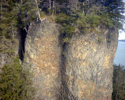
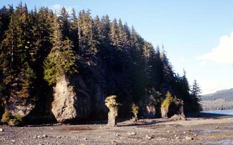
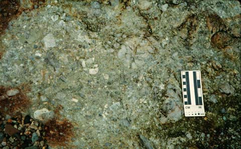
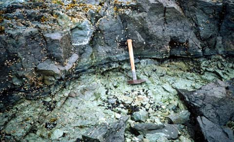
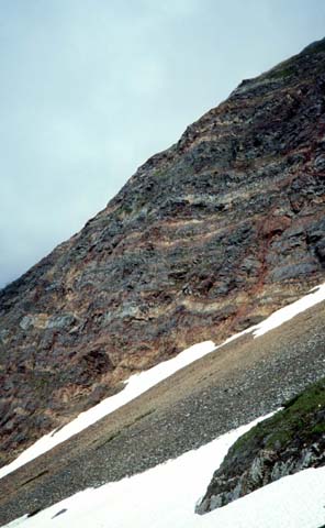
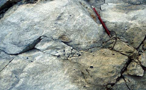
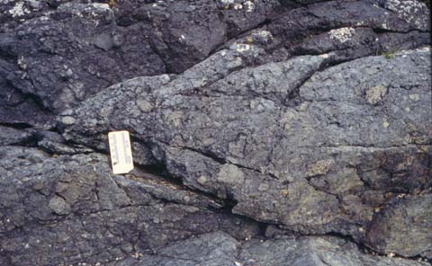
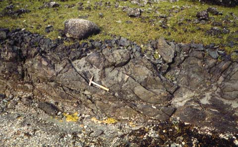
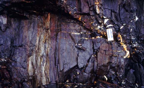
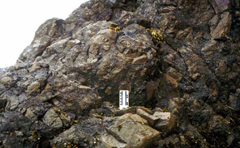
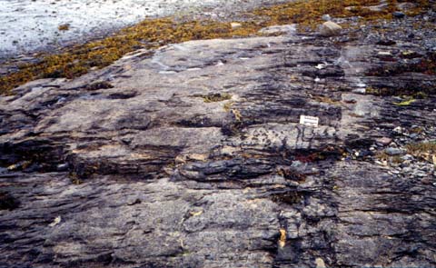
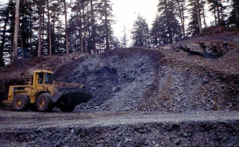
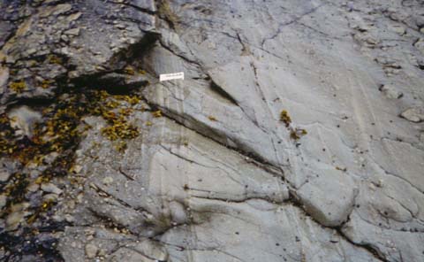
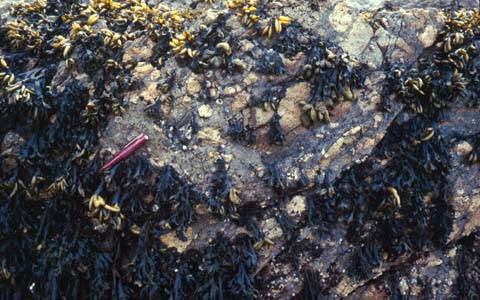
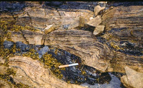
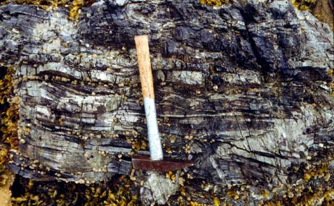
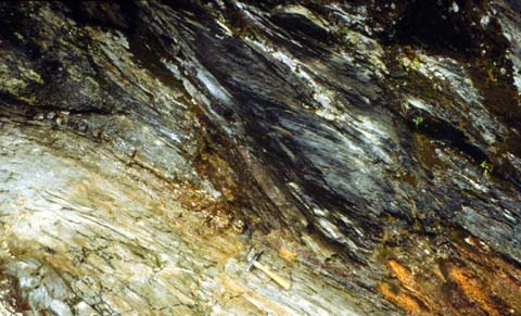
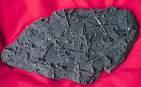
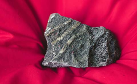
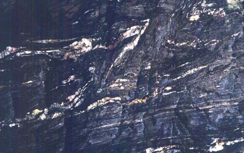
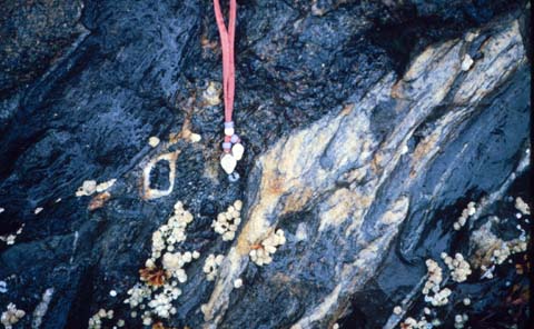
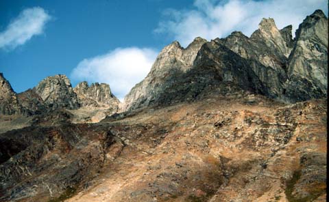
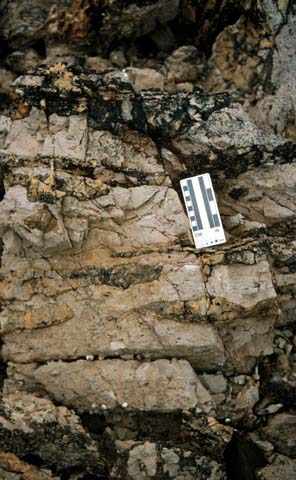
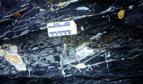
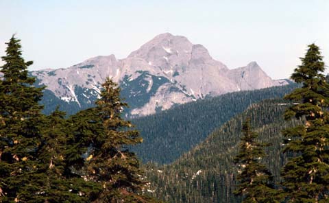
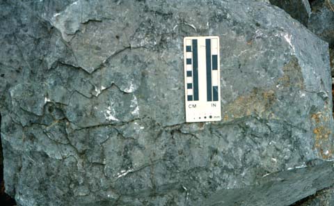
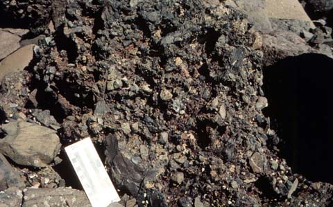
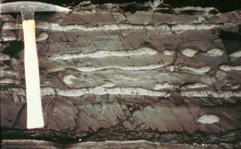
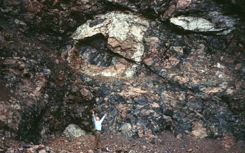
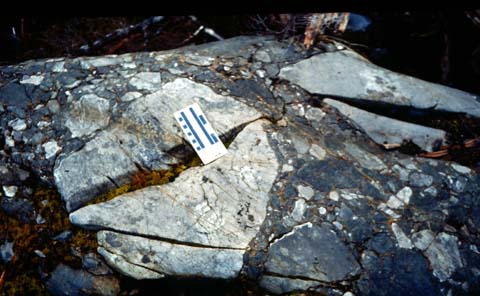
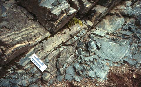
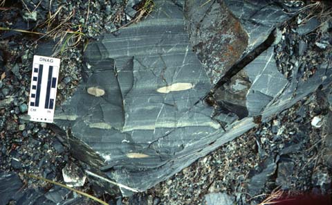
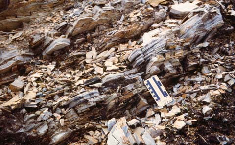
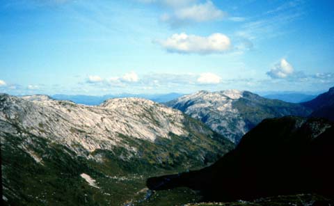
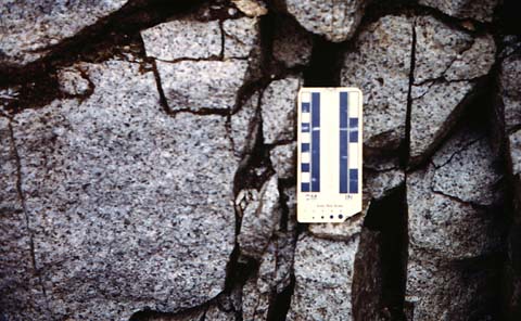
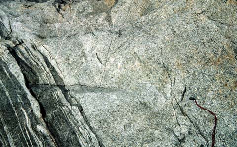
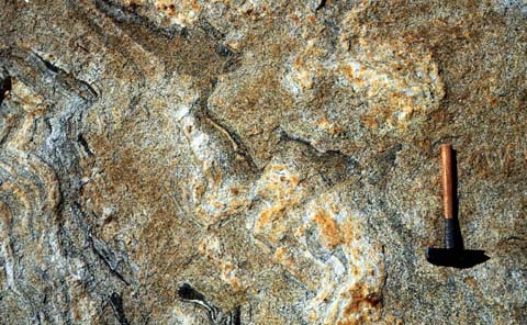
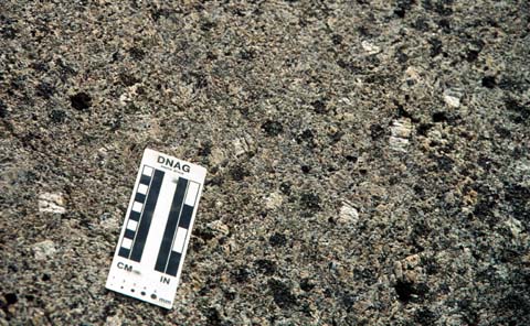
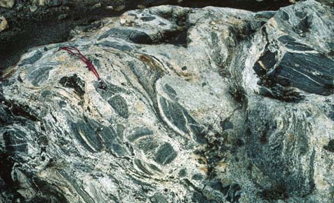
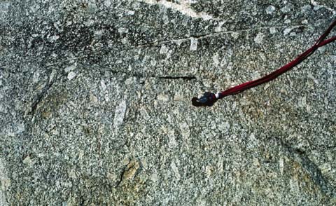
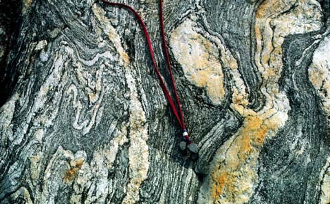
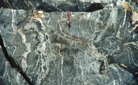
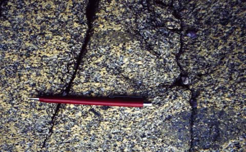
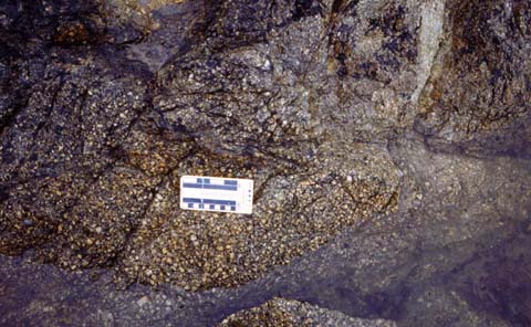
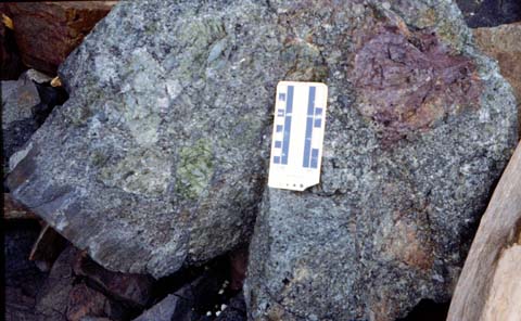
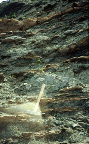
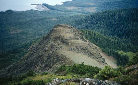