Ontario Geological Survey
B7-933 Ramsey Lake Road
Sudbury, Ontario P3P 1X7
Telephone: (705) 670-5725
Fax: (705) 670-5905
e-mail: brian.berdusco@ndm.gov.on.ca
With the initiation of the Abitibi Compilation Project the OGS decided to assess the usefulness of a full-blown GIS package capable of integration, compilation, analyses and exchange. To assess the degree to which this functionality was required, the OGS embarked on a "Functional Analysis" under the guidance of the Data Services Section. Following the Functional Analysis, a formal evaluation of several GIS platforms was completed and a GIS system that best satisfied the OGS Information Technology requirements was purchased.
Using the procedures developed in the Functional Analysis, compilation of the Timmins sheet took place and both a paper colored map and digital product were published in March of 1998. This product represents sheet one of a four-sheet product with the remainder slated for release by 2000.
Within the confines of the Timmins map sheet lies the Porcupine mining camp, one of the preeminent lode gold mining districts in the world. Significant base metal production has also come from this area, mainly from the Kidd Creek deposit. Komatiite-associated nickel deposits have been mined intermittently. Non-metallic minerals such as scheelite, asbestos and talc have also been extracted.
Concurrent with the Abitibi Compilation Project, the OGS continued development of digital line standards, mineral deposit symbol standards and symbol standards reflecting zones of alteration and deformation (stipple patterns). Other libraries under consideration include symbology for metallogenic classification, Quaternary geology and mineral commodity classification. The development process for each symbol library requires considerable effort. In an effort to decrease development time, the OGS has requested symbol libraries from other provincial, state and federal surveys.
To make effective use of symbol libraries in our GIS compilation, it is necessary to port existing libraries over to the GIS environment. Symbol libraries up to this point had only been developed for the CAD and cartographic environment. Off the shelf font creation software was used to create comparable symbols for the GIS environment. Symbols were converted on an "as required" basis. Eventually, symbol libraries will exist in both CAD and GIS formats. Pending the publication of standard OGS symbology for mineral deposits, the Abitibi Compilation Group adopted and modified the GSC mineral deposit symbology (Eckstrand et al, 1995). This symbology, though acceptable, does not classify based on metallogenic processes, a desired requirement of the OGS.
Digital line standards have been developed to reflect folds, faults and contacts. These standards will be incorporated into further releases and the final release of GIS products by the Abitibi Compilation Project.
Database development usually starts with the process of a business functional analysis. The objective of the analysis is to develop a business model of the organization (e.g. the OGS) or the specific function at hand (e.g. the Abitibi compilation). This business model depicts all the processes involved in completing the business function and is used as the basis for the following objectives:
There are various ways by which the business processes can be identified. The most commonly used method is to adopt a top-down approach in which business processes are identified and continuously decomposed until individual processes can be completed in one single activity or step. The result of this phase of the analysis is documented in the form of a Business Functional Hierarchy. An accompanying document, called Function Definitions, is then developed. The purpose of the Function Definitions is to explain in detail each of the processes (Figure 1). These two documents are used in the next phase of analysis to identify the information products generated by the business processes, which are documented in a Function-Information Product Table (Figure 1, Table 1). In the next phase of the analysis, the sources of the data are identified and documented in an Information Product-Data Table (Table 2).
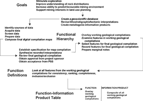
Figure 1. Functional Hierarchy.
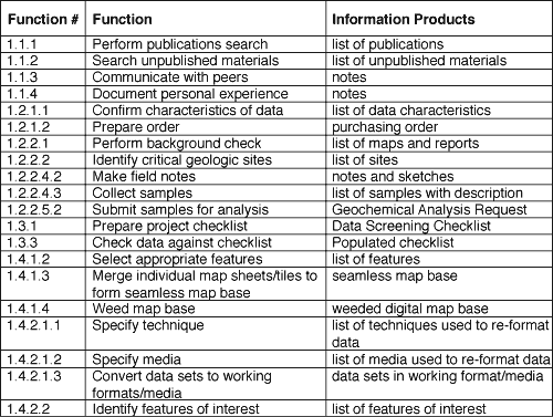
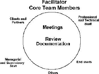
Figure 2. Joint Application Design. |
In the field of database management, there are different ways by which business functional analysis can be carried out. A popular approach appears to be the Joint Application Design (JAD) methodology (Figure 2), originally developed by IBM as the corporate standard for systems development. This method is based on the core team (also known as focus group) approach. A core team is made up of a facilitator, usually a systems analyst, and a group of five to seven members who are very familiar with the operation of the business. Other members can be coopted from time to time. These include: (1) professional and technical staff who are familiar with the operation of the business but do not have the time to attend all meetings; (2) specialists in certain aspects of the business who will be invited to give expert opinion in certain meetings; (3) managers and supervisory staff who need to keep themselves informed of the progress of the project; and (4) people outside the organization who have an interest, e.g. clients and partners.
The core team meets regularly. In the meetings, the team analyzes and discusses the characteristics of business processes; documents and edits records of discussion (i.e. the Business Functional Hierarchy and the Function Definitions); as well as identifies information products and data sources (which results in the documentation of the Function-Information Product Table and the Information Product-Data Table). At certain milestones, documents resulting from the core team meetings were sent out to other interested parties for comment. The core team is responsible for the review and consolidation of these comments and suggestions into the original JAD documentation.
The JAD methodology is a very effective way of performing business functional analysis. Since it is based on face-to-face and group meetings, it provides a working environment for open communication. It also provides a structure for consensus building by focusing on issues and resolving them. Participation in the meetings is a very useful educational experience for existing and potential users of the data to be delivered. Finally, as the deliverables of the core team are well documented, it provides a solid foundation for data modeling in database design. An example of the Abitibi Functional Analysis is provided in Appendix 1.
The following approach was developed to ensure that the GIS system meets these objectives:
The following "soft" evaluation criteria were also considered:
An example of the Evaluation Form is provided in Figure 3. Those interested in a complete copy may contact the authors for the form in a Microsoft Excel format. For each function there is a minimum required score. Raster capabilities were considered less important for our applications than vector, and consequently they contribute less to the overall score.
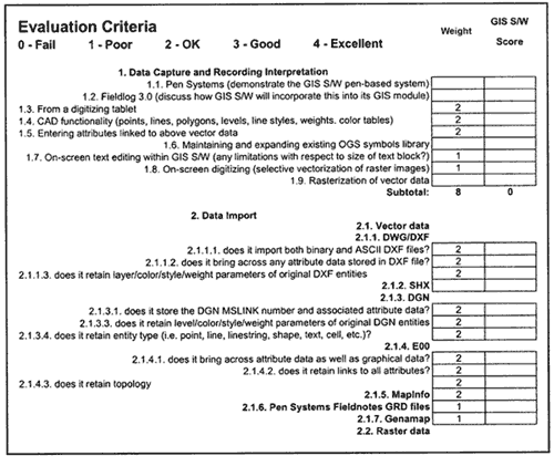
Figure 3. Example of Evaluation Form
There was a period of follow-up for several weeks after each evaluation. For example, vendors sent us plot files and export files, which they did not have the time to create at our site. They also provided the necessary information to complete our "soft" evaluation criteria (e.g. support, training, and a list of organizations that use the specific software).
The products showed strengths and weaknesses in different areas of our evaluation, but tabulating the scoring of the functional evaluation criteria indicated which products would best suit us.
We also considered the previously discussed "soft" factors. We wanted to be compatible with as many of our geological colleagues as possible and therefore considered the software being used by the Geological Survey of Canada as well as neighboring provincial and state geological surveys. Finally, we considered Ontario government software standards and the software used by the Ontario Ministry of Natural Resources, our source for digital topographic data as well as the Ontario government's lead ministry in GIS Information Technology.
The process of compilation that was used came directly from the Functional Analysis (Appendix 1). The Data Screening Checklist (Table 3), also a product of the functional analysis, clearly lays out the data sets we had to work with and what features were pertinent to the compilation process. For our purposes, we subdivided the data into two sets - Map Data and Tabular Data.
Map Data include both vector and raster data sets including the following themes:
Tabular data consisted of the following databases:
NOTE: As stated throughout, numerous tables and figures have been reduced in size and breadth in the interests of brevity. Should you require comprehensive documentation, tables will be provided in MS-Excel and MS-Word by simply contacting one of the authors.
Brodaric, B., 1997, Field data capture and manipulation using GSC Fieldlog v3.0, in D.R. Soller, editor, Digital Mapping Techniques '97, Proceedings of a Workshop on Digital Mapping Techniques: Methods for Geologic Map Data Capture, Management and Publication: U.S. Geological Survey Open-File Report 97-269, p. 77-81, http://ncgmp.usgs.gov/pubs/of97-269/brodaric.html.
Eastman, J.R., 1995, Idrisi for Windows User's Guide Version 1.0: Clark Labs for Technology and Geographic Analysis, Clark University, 950 Main Street, Worcester, Massachusetts 01610-1477, United States.
Eckstrand, O.R., Sinclair, W.D. and Thorpe, R.I., 1995, Geology of Canadian Mineral Deposit Types: Geological Survey of Canada, Geology of Canada, no. 8.
Gupta, V.K., 1996, Ontario airborne magnetic and electromagnetic surveys: Archean and Proterozoic "Greenstone" belts; in Summary of Field Work and Other Activities 1996: Ontario Geological Survey, Miscellaneous Paper 166, p. 168-176.
Gupta, V.K., 1995, Processing of airborne magnetic and electromagnetic surveys-progress report; in Summary of Field Work and Other Activities 1995: Ontario Geological Survey, Miscellaneous Paper 164, p. 299-300.
Jackson, S.L., and Fyon, J.A., 1991,The western Abitibi Subprovince in Ontario; in Geology of Ontario: Ontario Geological Survey, Special Volume 4, Part 1, p. 404-482.
Jackson, S.L., Muir, T.L. and Romkey, S.W., 1995, A library of digital mapping symbols. Part I: digital files, figures and descriptions: Ontario Geological Survey, Open File Report 5909, 56 p.
Madon, Z., Trowell, N.F. and Ayer, J.A., 1997, Using Radarsat data for geoscientific applications, Abitibi greenstone belt, Ontario; p. 10 ń13 in Summary of Field Work and Other Activities: Ontario Geological Survey, Miscellaneous paper 168, 149 p.
Martin, J, 1990, Information Engineering, Book II: Planning and Analysis: Prentice-Hall, Incorporated, College and Technical Reference Division, Englewood Cliffs, New Jersey 07632, United States.
Muir, T.L., 1995, A library of digital mapping symbols. Part 2: Appendix B (listing and explanation of symbol acronyms): Ontario Geological Survey, Open File Report 5910, 116 p.
Rogers, M.C., Thurston, P.C., Fyon, J.A., Kelly, R.I. and Breaks, F.W., 1996, Mineral deposit models of metallic and industrial deposit types and related mineral potential assessment criteria: Ontario Geological Survey Open File Report 5916.
Thurston, P.C., 1996, The Abitibi Field Investigations: a Rationale; in Summary of Field Work and Other Activities: Ontario Geological Survey, Miscellaneous Paper 166, p. 3-4.
Yeung, A., 1995, Introduction to Geographic Information Systems, Instructional Materials and Course Notes for fourth-year Geography course: Department of Geography, Laurentian University, Sudbury, Ontario.
Appendix 1. ABITIBI FUNCTIONAL ANALYSIS
Abitibi Compilation - Project Documentation (Note: the content of the following has been greatly reduced in the interests of brevity. Should you require additional detail, please contact one of the authors at the Ontario Geological Survey)
1. Business Activities
2. Goals
3. Objectives and Scope
4. Usefulness
5. Clients
6. Custodians
7. Sponsor
8. CREATE A GEOSCIENTIFIC DATABASE
9. REVISE LITHOSTRATIGRAPHIC/TECTONIC INTERPRETATIONS
10. CREATE METALLOGENIC INFORMATION PRODUCTS
(The analysis of this function is in progress. Function definitions and tables to be completed)
|
Return to Table of Contents
This site is https://pubs.usgs.gov/openfile/of99-386/berdusco.html
|