National Park Service
1201 Oak Ridge Drive, Suite 350
Fort Collins, CO 80525
Telephone: (970) 225-3559
Fax: (970) 225-3585
e-mail: Joe_Gregson@nps.gov
apoole@co.blm.gov
Steve_Fryer@nps.gov
Bruce_Heise@nps.gov
Tim_Connors@nps.gov
Kay_Dudek@nps.gov
The GeoBib project is completing the initial phase of data collection for existing geologic resources (maps and literature) in each NPS unit and publishing the data on the Internet (URL: http://165.83.36.151/biblios/geobib.nsf/ LOGIN: geobib read PASSWORD: anybody). In addition, index maps showing the location of associated geologic maps have been prepared for the parks in Colorado and Utah. In general, after map coverage for each park is determined, map products can be evaluated, and if needed, additional mapping projects identified and initiated.
Pilot geologic issues/map scoping workshops (with attendees referred to as Park Teams) were organized in 1998 to evaluate the resources in Colorado parks and will continue with projects in Utah during 1999. Park Teams evaluate existing maps for existing and potential digital products and identify any new geologic mapping needs. New geologic mapping projects may be initiated on a case-by-case basis after careful evaluation of park needs, costs, potential cooperators, and funding sources.
GRI cooperators are also assisting with geology-GIS standards to ensure uniform data quantity and quality for digital geologic maps. In addition to standardized data definitions and structure, NPS resource managers also need user-friendly GIS applications that allow the digital geologic map products to "look and feel" like the original published maps. Ongoing pilot digitization projects are providing additional experience and test beds for the geology-GIS model.
Park workshops suggest several applications for park resource management from an enhanced understanding of the parks' geology. Examples include the use of geologic data to construct fire histories, to identify habitat for rare and endangered plant species, to identify areas with cultural and paleontological resource potential, and to locate potential hazards for park roads, facilities, and visitors. Digital geologic maps will enhance the ability to develop precise hazard and resource models in conjunction with other digital data.
After completion of map inventories, a geologic report summarizing USGS, state, academic, and NPS geological literature and data will complete the project for each of the 265 park units. The geologic report content, format, and database are still being developed.
The NPS Geologic Resources Inventory is being actively developed with the cooperation of USGS and state geological surveys. However, many opportunities for project collaboration exist that have not yet been identified, and effective communication among cooperators is a key factor for success of the inventory. Another challenge of inventory planning is the development of digital map standards that are adaptable to diverse geological conditions but still provide quality, uniform products and firm guidance for map developers. Indeed, the diversity of geologic resources found in the National Park System will provide a continuing challenge for effective project management. The National Park Service has identified GIS and digital cartographic products as fundamental resource management tools, and the I&M Program and Geological Resources Division are developing an efficient inventory program to expedite the acquisition of digital geologic information for NPS units throughout the country.
Since NPS resource managers use GIS as a tool in a wide array of collateral duties, the I&M Program is developing most digital products in ArcView GIS. ArcView interfaces effectively with other software running on the MS Windows operating system, and a new approach using the Windows help software, a MS Visual Basic graphics viewer program, the ArcView legend editor, and the Avenue script language has been developed to automate the display and query of published map information in the GIS.
The Windows help system begins with data input or import of all the textual data from the published geologic map(s). In the Black Canyon/Curecanti pilot project, map descriptions, references, notes, and other text were aggregated from eight geologic maps. The table of contents listed all of the map unit symbols and names (equivalent to the class_label and class_desc fields of the AASG/USGS GMDM Classification Object Table) sorted by geologic age. Subsequent pages listed the map unit descriptions with one unit per page (many units had multiple descriptions from different maps) and were paginated by geologic age. At the end, references and notes from each map were entered on separate pages. Help context IDs, topic names, keywords, page numbers, and linking codes were added to the pages which were saved as a rich text format (.rtf) file. Then, the rich text file was compiled into a Windows help file.
Once compiled, the Windows help file can be opened and used with almost any MS Windows software. The table of contents has each map unit symbol and unit name "hot-linked" to the descriptions, and each description is hot-linked to the references and notes. Using the built-in Windows help tools, users can jump instantly to the table of contents, page through the age-sorted unit descriptions, search for keywords, or index the file and perform full-text searches of the entire file. The Black Canyon/Curecanti pilot project help file consists of more than 50 printed pages of information for more than 130 map units. Advantages of the Windows help file are that most text formatting, such as font, size, color, etc., are preserved in the final product, many graphics and tables are also supported, and the help system can be developed somewhat independently of the digital geologic map.
In ArcView GIS, three Avenue scripts were written to function with a toolbar button to automate the Windows help file and call unit descriptions interactively from the geologic map. The button tool is only active when the geology theme is turned on. The user selects the map unit help tool from the ArcView toolbar and clicks on the desired map unit to view the associated unit description. Using the map unit symbol (GUNIT_SYM) and the corresponding help context ID, the Avenue routine loads the Windows help file and pages to the map unit description. Thus, the map unit descriptions and other text are instantly available to the user of the digital map.
To prepare the cross sections for viewing, the graphics are first scanned at 100 dots-per-inch (DPI) and saved as a digital JPEG (.jpg extension) graphics file. The JPEG format was chosen to allow the graphics to be served and viewed over the Internet in the future. Once again, the 8.3 file naming convention is used to facilitate sharing across all platforms, and file names are based on the map series designation and the designated cross section on the map (e.g., GQ1516AA.JPG is the A-A' cross section on the Geologic Quadrangle Map GQ-1516).
Although ArcView and the Avenue language provide several ways to display graphics and images, ArcView's capabilities are inadequate for efficient viewing of cross sections that could be up to 6" x 48" in size. Therefore, a simple VB graphics viewer program was developed to provide this capability. The viewer displays the graphics at 100% with the ability to scroll from one end of the section to the other.
To automate the graphics display, the cross section lines were digitized into an ArcView shape file (e.g., blcagsec.shp and associated extensions). Two text fields were added to the shape file table (e.g., blcagsec.dbf): GSEC_ID, which contains the section line (e.g., A-A'), and GSEC_FILE, which contains the complete path and filename of the cross section graphics file.
In ArcView GIS, three Avenue scripts were written to function with a toolbar button to automate the cross sections and call graphics files interactively from the geologic map. The button tool is only active when the cross section theme is turned on. The user selects the cross section viewer tool from the ArcView toolbar and clicks on the desired cross section line displayed on the map. Using the cross section line and the corresponding filename, the Avenue script loads the graphics viewer and displays the selected section. Thus, the cross sections are interactively available to the user of the digital map.
|
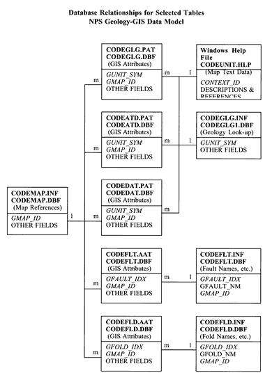
Figure 1. Simplified relationships among the database tables discussed and outlined in the text. Bold type denotes database file names for Arc/Info (top) and ArcView (below). The tabular relationships are coded with "m" for many and "1" for one. Related field names are in italics. |
The models display areas with potentially high vulnerability to destructive processes (Figure 2), particularly if the land is disturbed (such as by wildfire, road building, and drainage diversion). Simple GIS overlays of these maps provide guides to making land-use decisions, such as routing a road. The models are created using Arc/Info's GRID module, which performs raster-based analysis. Results of the models can be viewed as images within ArcView, or converted into a vector format to allow the model results to be queried. The models can be improved by collecting better quality information on soils, more detailed slope maps, and better precipitation data.
| Table 1. Coverages/Shape Files (modified from Harris, 1998) | ||
| Present work is focusing on renaming files to consistently use the 8.3 file name convention with the NPS park unit alpha code (CODE) and to limit field names to 10 characters or less. | ||
| *CODEGLG | poly | Map units or main geologic spatial data containing both polygon data describing the map units and linear data describing the interface between those units (WSM GUNIT). |
| *CODEGLN | line | Map units or main geological spatial data represented as lines due to map scale limitations (WSM GUNITLN). |
| *CODEGPT | point | Map units or main geological spatial data represented as points due to map scale limitations (WSM GUNITPT). |
| *CODEFLT | line | Faults and their descriptions (WSM GFAULT). |
| *CODEFLD | line | Linear fold axes and their descriptions (WSM GFOLD). |
| *CODESEC | line | Cross section lines and their attributes (no WSM equivalent). |
| *CODEATD | point | Attitude observation points and their attributes (WSM GATTUD). |
| *CODEDAT | point | Age-date sample location points (fossil or radiometric age estimates) (WSM GDTSMPL). |
| *CODEVNT | point | Volcanic vents, eruptive centers, and lithologic descriptions (WSM GVENT). |
| *CODEDIK | line | Individual lithologic dikes and lithologic descriptions (WSM GDIKE). |
| *CODEDKS | poly | Areas of lithologic dikes too numerous to map as individual segments (WSM GDIKESWARM). |
|
Coverages/Shape Files Data Dictionary
*CODEGLG (network coverage containing both arc (.AAT) and polygon (.PAT) attribution) DATA FILE NAME: CODEGLG.PAT or CODEGLG.DBF |
||
| ITEM NAME | WID-TYP | DESCRIPTION |
| AREA | 4 - F | |
| PERIMETER | 4 - F | |
| *GUNIT_ | 4 - B | (WSM GUNIT#; automatically converted in shape file .dbf) |
| *GUNIT_ID | 4 - B | (WSM GUNIT-ID; automatically converted in shape file .dbf) |
| *GUNIT_IDX | 6 - I | unique number for each polygon (WSM GUNIT.ID) |
| *GUNIT_SYM | 12 - C | age-lithology unit symbol (WSM GUNIT.LABEL.CD) |
| *USGS_SYM | 12 - C | geologic symbol from USGS geologic map(s) |
| *G_AGE_NO | 4 - F | number to age-sort map units (from *CODEGLG.INF table) |
| *GMAP_ID | 4 - I | code for *CODEMAP.INF look-up table (WSM GMAP.ID) |
|
*GUNIT_SYM (map unit symbol in ASCII text; WSM GUNIT.LABEL.CD, GMDM class_label) Age-lithology unit polygon labels. Item is also the key used to relate the *CODEGLG coverage with the *CODEGLG.INF or CODEGLG1.DBF (WSM GUNIT.MAIN) file that contains additional geologic attributes for the polygons.
*GMAP_ID (geologic map source information)
DATA FILE NAME: CODEGLG.AAT
|
||
| ITEM NAME | WID-TYP | DESCRIPTION |
| *FNODE_ | 4 - B | (WSM FNODE#; automatically converted in shape file .dbf) |
| *TNODE_ | 4 - B | (WSM TNODE#; automatically converted in shape file .dbf) |
| *LPOLY_ | 4 - B | (WSM LPOLY#; automatically converted in shape file .dbf) |
| *RPOLY_ | 4 - B | (WSM RPOLY#; automatically converted in shape file .dbf) |
| LENGTH | 4 - F | |
| *GUNIT_ | 4 - B | (WSM GUNIT#; automatically converted in shape file .dbf) |
| *GUNIT_ID | 4 - B | (WSM GUNIT-ID; automatically converted in shape file .dbf) |
| *GCNTCT_IDX | 7 - I | unique number for each arc segment (WSM GCNTCT.ID) |
| *GCNTCT_TYP | 1 - I | code for types of polygon boundaries (contacts) (WSM GCNTCT.TYPE.CD) |
| FLTCNT | 1 - C | flags lithologic contacts that are also faults |
| *GMAP_ID | 4 - I | code for *CODEMAP.INF look-up table (WSM GMAP.ID) |
*GCNTCT_TYP (polygon boundary/geologic contact type code)
FLTCNT (fault contact)
*CODEFLT (arc or line coverage) DATA FILE NAME: CODEFLT.AAT or CODEFLT.DBF |
||
| ITEM NAME | WID-TYP | DESCRIPTION |
| *FNODE_ | 4 - B | (WSM FNODE#; automatically converted in shape file .dbf) |
| *TNODE_ | 4 - B | (WSM TNODE#; automatically converted in shape file .dbf) |
| *LPOLY_ | 4 - B | (WSM LPOLY#; automatically converted in shape file .dbf) |
| *RPOLY_ | 4 - B | (WSM RPOLY#; automatically converted in shape file .dbf) |
| LENGTH | 4 - F | |
| *GFAULT_ | 4 - B | (WSM GFAULT#; automatically converted in shape file .dbf) |
| *GFAULT_ID | 4 - B | (WSM GFAULT-ID; auto-converted in shape file .dbf) |
| *GFAULT_IDX | 5 - I | unique ID number for each fault (WSM GFAULT.ID) |
| *GFLT_SEG_N | 4 - I | unique number for each fault segment (GFLTSEG.NO) |
| *GFLT_SEG_T | 3 - I | code value used to differentiate fault types and characteristics of the fault at the segment level (GFLTSEG.TYPE.CD) |
| FLTCNT | 1 - C | flags faults that are also lithologic contacts |
| *GMAP_ID | 4 - I | code for *CODEMAP.INF look-up table (WSM GMAP.ID) |
|
*GFAULT_IDX (geologic fault ID)
A geologic fault is commonly segmented as a result of intersecting different polygons. This item identifies an individual fault regardless of the number of segments. This item is also a key used to relate the *CODEFLT coverage with the *CODEFLT.INF file that contains fault names and data. GFLT_SEG_T (geologic fault segment type code)
FLTCNT (fault contact)
*CODEFLD (arc or line coverage) DATA FILE NAME: CODEFLD.AAT or CODEFLD.DBF |
||
| ITEM NAME | WID-TYP | DESCRIPTION |
| *FNODE_ | 4 - B | (WSM FNODE#; automatically converted in shape file .dbf) |
| *TNODE_ | 4 - B | (WSM TNODE#; automatically converted in shape file .dbf) |
| *LPOLY_ | 4 - B | (WSM LPOLY#; automatically converted in shape file .dbf) |
| *RPOLY_ | 4 - B | (WSM RPOLY#; automatically converted in shape file .dbf) |
| LENGTH | 4 - F | |
| *GFOLD_ | 4 - B | (WSM GFOLD#; automatically converted in shape file .dbf) |
| *GFOLD_ID | 4 - B | (WSM GFOLD-ID; auto-converted in shape file .dbf) |
| *GFOLD_IDX | 6 - I | unique ID number for each fold (WSM GFOLDT.ID) |
| *GFLD_SEG_N | 3 - I | unique number for each fold segment (GFOLDSEG.NO) |
| *GFLD_SEG_T | 2 - I | code value used to differentiate fold types and characteristics of the fold at the segment level (GFOLDSEG.TYPE.CD) |
| *GMAP_ID | 4 - I | code for *CODEMAP.INF look-up table (WSM GMAP.ID) |
|
*GFOLD_IDX (geologic fold ID)
A geologic fold is commonly segmented as a result of intersecting different polygons. This item identifies an individual fold regardless of the number of segments. This item is also a key used to relate the *CODEFLD coverage with the *CODEFLD.INF file that contains fold names and data. GFLD_SEG_T (geologic fold segment type code)
*CODEATD (point coverage or shape file) DATA FILE NAME: CODEATD.PAT or CODEATD.DBF |
||
| ITEM NAME | WID-TYP | DESCRIPTION |
| AREA | 4 - F | |
| PERIMETER | 4 - F | |
| *GATTUD_ | 4 - B | (WSM GATTUD#; auto-converted in shape file .dbf) |
| *GATTUD_ID | 4 - B | (WSM GATTUD-ID; auto-converted in shape file .dbf) |
| *GATTUD_IDX | 5 - I | unique number for each point (WSM GATTUD.ID) |
| *GATTUD_CD | 2 - I | code for type of attitude measurement (WSM GATTUD.CD) |
| *GATTUD_ST | 3 - I | azimuth of strike or trend (0-360 degrees clockwise from the north with dip direction clockwise from strike direction) |
| *GATTUD_DP | 2 - I | dip or plunge degrees from horizontal (GATTUD.DIP.ANG) |
| *GMAP_ID | 4 - I | code for *CODEMAP.INF look-up table (WSM GMAP.ID) |
*GATTUD_CD (observation code for structural attitude point)
*CODEDAT (point coverage or shape file) DATA FILE NAME: CODEDAT.PAT or CODEDAT.DBF |
||
| ITEM NAME | WID-TYP | DESCRIPTION |
| AREA | 4 - F | |
| PERIMETER | 4 - F | |
| *GDTSM_ | 4 - B | (WSM GDTSMPL#; auto-converted in shape file .dbf) |
| *GDTSM_ID | 4 - B | (WSM GDTSMPL-ID; auto-converted in shape file .dbf) |
| *GDTSM_CD | 2 - I | code for age-dating technique (WSM GDTSMPL.METH.CD) |
| *GDTSM_NO | 3 - I | unique code for each age sample location (GDTSMPL.NO) |
| *GDTSM_AGE | 80 - C | relative or absolute age of rock sample (WSM AGE) |
| *GDTSM_REM | 254 - C | notes about a specific age-date sample (WSM REMARKS) |
| *GUNIT_SYM | 12 - C | age-lithology unit symbol (WSM GUNIT.LABEL.CD) |
| *GMAP_ID | 4 - I | code for *CODEMAP.INF look-up table (WSM GMAP.ID) |
*GDTSM_CD (geologic sample age-dating methodology code)
*GDTSM_NO (geologic data sample number)
*GUNIT_SYM (map unit symbol in ASCII text)
*GDTSM_AGE (age of rock sample)
*GDTSM_REM (remarks)
Other Coverages/Shape Files |
||
| The other coverage/shape files listed above have not yet been evaluated or adapted for the NPS geology-GIS data model, but the renaming of files and data fields will follow a similar pattern. | ||
|
Accessory Data Files
*CODEGLG.INF (look-up data file, WSM GUNIT.MAIN)
|
||
| ITEM NAME | WID-TYP | DESCRIPTION |
| *GUNIT_SYM | 12 - C | age-lithology unit symbol (WSM GUNIT.LABEL.CD) |
| *GUNIT_NAME | 100 - C | formal name of map unit, if any |
| *G_REL_AGE | 5 - C | relative age code (WSM GUNIT.REL.AGE.CD) |
| *G_SSCR_TXT | 6 - C | subscript from the map symbol (WSM GUNIT.SSCRPT.TXT) |
| *G_AGE_NO | 5 - N | number to age-sort map units (WSM GUNIT.AGE.NO) |
| *G_AGE_TXT | 50 - C | geologic time period of map unit (WSM GUNIT.AGE.TXT) |
| *G_MJ_LITH | 3 - C | 3 char. major lithology code (WSM GUNIT.MJ.LITH.CD) |
| *G_LITH_NO | 4 - B | code used to sort on lithology (WSM GUNIT.LITH.NO) |
| *G_LITH_CD | 10 - I | code used to describe lithology (WSM GUNIT.LITH.CD) |
| *G_LITH_TXT | 100 - C | brief text describing lithology (WSM GUNIT.LITH.TXT) |
| *G_NOTE_TXT | 254 - C | descriptive notes about the map unit (GUNIT.NOTE.TXT) |
| *GMAP_SRC | 100 - C | GMAP_IDs of map source(s), if any (similar to GMDM source_id) |
*G_MJ_LITH (map unit major lithology code)
Example record from *CODEGLG.INF or *CODEGLG1.DBF (modified from Harris, 1998)
*CODEMAP.INF (WSM GMAP and GMAP.TXT INFO look-up data files combined/modified with Map and Source tables from AASG/USGS GMDM) DATA FILE NAME: *CODEMAP.INF or *CODEMAP.DBF |
||
| ITEM NAME | WID-TYP | DESCRIPTION |
| *GMAP_ID | 4 - I | code for relating this table (WSM GMAP.ID, GMDM map_id) |
| *GMAP_YEAR | 4 - I | compilation or publication year (WSM GMAP.COMPILE.YR) |
| *GMAP_AUTH | 254 - C | map author(s) (WSM GMAP.AUTHOR.YR; GMDM map_author) |
| *GMAP_ORG | 100 - C | organization that created or compiled the map (GMDM org_id) |
| *GMAP_TITLE | 100 - C | complete map title (WSM GMAP.REF.TXT; GMDM map_title) |
| *GMAP_SERIES | 20 - C | map series or organizational identifier (e.g., USGS GQ-1516) |
| *GMAP_SCALE | 7 - I | source map scale denominator (WSM GMAP.SCL) |
| *GMAP_PROJ | 100 - C | name or description of map projection (GMDM map_projection) |
| *GMAP_REF | 254 - C | complete map citation in USGS style |
| *GMAP_DESC | 254 - C | brief description of the map (GMDM map_desc) |
| *GMAP_XMAX | 7 - I | eastern limit of map in decimal degrees (GMDM map_xmax) |
| *GMAP_XMIN | 7 - I | western limit of map in decimal degrees (GMDM map_xmin) |
| *GMAP_YMAX | 7 - I | northern limit of map in decimal degrees (GMDM map_ymax) |
| *GMAP_YMIN | 7 - I | southern limit of map in decimal degrees (GMDM map_ymin) |
| *GMAP_SRC | 100 - C | GMAP_IDs of map source(s), if any (similar to GMDM source_id) |
|
*CODEFLT.INF (look-up data file)
DATA FILE NAME: CODEFLT.INF or CODEFLT1.DBF |
||
| ITEM NAME | WID-TYP | DESCRIPTION |
| *GFAULT_IDX | 5 - I | unique ID number from *CODEFLT (WSM GFAULT.ID) |
| *GFAULT_NM | 60 - C | fault name, if any (WSM GFAULT.NM) |
| *GMAP_ID | 4 - I | code for *CODEMAP.INF look-up table (WSM GMAP.ID) |
|
*CODEFLD.INF (look-up data file)
DATA FILE NAME: CODEFLD.INF or CODEFLD1.DBF |
||
| ITEM NAME | WID-TYP | DESCRIPTION |
| *GFOLD_IDX | 5 - I | unique ID number from *CODEFLD (WSM GFOLD.ID) |
| *GFOLD_NM | 60 - C | fold name, if any (WSM GFOLD.NM) |
| *GMAP_ID | 4 - I | code for *CODEMAP.INF look-up table (WSM GMAP.ID) |
Harris, Carl F.T., 1998, Washington State's 1:100,000-Scale Geologic Map Database: An Arc/Info Data Model Example, in David R. Soller, ed., Digital Mapping Techniques '98--Workshop Proceedings: U.S. Geological Survey Open-File Report OFR 98-487, p. 27-35, https://pubs.usgs.gov/openfile/of98-487/harris.html.
Johnson, Bruce R., Boyan Brodaric, and Gary L. Raines, 1998, Draft Digital Geologic Map Data Model, Version 4.2: Association of American State Geologists/U.S. Geological Survey Geologic Map Data Model Working Group Report, May 19, 1998, http://ncgmp.usgs.gov/ngmdbproject/.
|
Return to Table of Contents
This site is https://pubs.usgs.gov/openfile/of99-386/gregson.html
|