By Diane E. Lane, Alex Donatich, F. Craig Brunstein, and Nancy A. Shock
U.S. Geological Survey
Box 25046
Denver Federal Center, MS 902
Denver, CO 80225
Telephone: (303) 236-5476
Fax: (303) 236-6287
e-mail: delane@usgs.gov
During the transition from manual to digital cartographic preparation of thematic maps over the past several years the Central Publications Group (CPG) of the Geologic Division, U.S. Geological Survey (USGS), has produced maps from a variety of compilation materials submitted by authors: conventional drafting on film; maps digitized by authors or contractors in GSMAP or, more recently, GSMCAD (both programs available at http://ncgmp.cr.usgs.gov/ncgmp/gsmcad/ or http://greenwood.cr.usgs.gov/maps/software.html; for a description, see Williams, 1997); maps digitized by authors or contractors in Arc/Info; maps drafted by authors in a graphics program, such as Adobe Illustrator; maps generated by programs widely used by USGS geophysicists; and hybrid maps using more than one of these approaches. Some authors produce final cartographic layouts for their maps themselves, and others rely on CPG for final production. Along the way we have encountered problems with digital production from these various sources but have found solutions to the extent that most of the maps currently in production are wholly digital in the sense that the map is output from a digital file.
In addition to the challenge of producing maps from such a variety of compilation materials, we need to produce maps for release online, for plotting on demand on a high-resolution plotter, and for printing on a press; we also need to work with authors to place digital databases and metadata online. Our poster presentation for this workshop outlines some procedures for producing maps that work for us in our publications environment.
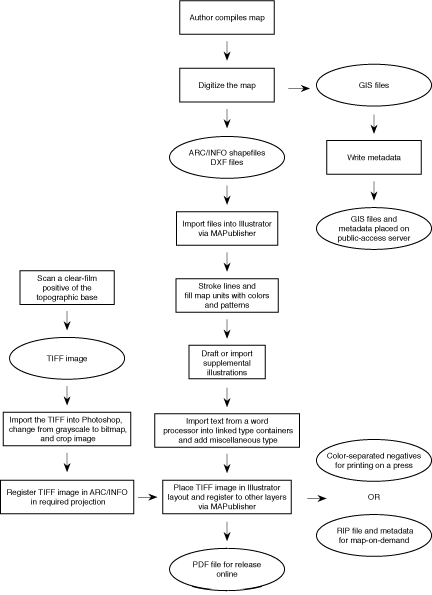
Figure 1. Chart showing basic procedure for digital map production and database development in the
Central Publications Group of the Geologic Division, U.S. Geological Survey.
Before contracting for the digitizing we sometimes choose first to have a cartographic contractor scribe very complex conventionally drafted linework. The contractor scribes one sheet of color boundaries and one or two (depending on complexity) other sheets of lines (such as faults, folds, or caldera boundaries), using a uniform line weight of 0.006 inches and omitting line decorations and point symbols. In some cases we have the contractor ink the map unit symbols on an overlay. We then have clear-film positives made from the scribes and furnish these materials to the digitizing contractor for scanning.
If the linework is not too complex, inked compilations on film are scanned directly. Whether separates are scribed or the original compilation is scanned, we ask the author to make color-coded line and symbol guides to help the contractor accurately attribute polygons, lines, and point symbols. Point symbols on overlays or on the original compilation on film are either (1) digitized by hand or (2) scanned and then used on-screen as a guide for digitizing point symbols in a graphics program. In some cases we provide the digitizing contractor with scans of the topographic base, especially if needed to digitize open-water boundaries.
In contracting for digitizing, we provide standards for accuracy and for coverage attributing. In order to meet our need for both a digital database and usable graphics files, we request two files to represent point symbols. One is an attributed Arc/Info point coverage, and the other is a line coverage that graphically represents the point symbols. Symbols such as the bar and ball on faults or displacement arrows on folds are represented as points (on the line) and attributed accordingly. In other words, we do not want such symbols to be evenly spaced along a line as a decoration such as sawteeth would be, but to be placed exactly where the author placed them.
For maps digitized in a CAD program, DXF files import properly for polygons, lines, point symbols, and text. For maps from Arc/Info, we import shapefiles for the polygons and lines but use DXF files for the text and for graphical representations of point symbols. In CPG we have worked most extensively with ArcView shapefiles and DXF files. In importing a set of files for a map, it is important not to move the objects imported into Illustrator via MAPublisher until all files have been imported in proper registration.
Cross sections and other supplemental illustrations may be digitized in a CAD program or in Arc/Info, or they may be drafted in a graphics program. GIS files for these illustrations may be imported into the graphics program in the same manner as the map itself. We generally import these into their own Illustrator document to keep the working file size small and adjust lines and colors as we do on the map itself. Layers for these supplemental illustrations can be preserved by checking "paste remembers layers" in Illustrator when copy-pasting the illustration into the layout. However, you will not be able to use the "select by attribute" function of MAPublisher to edit an illustration that is no longer in the Illustrator document into which it was imported.
In choosing colors for a map, we consider whether the map will be printed on a press or only on a plotter. In both cases we follow USGS standards for assigning colors by age and rock type. We choose colors from standard sheets of printed process colors for maps that will be printed on a printing press, but we use a plotted version of the color chart to refine color choices for maps that will be printed only on a plotter. Since plotters differ in their output, we use color charts printed on the same kind of plotter as that used to print maps in the maps-on-demand series for sale to the public.
Using Illustrator, everything that can be done in the nondigital production of a map can be duplicated, including adding patterns to color-filled polygons. We have available in digital form many of the patterns traditionally used on USGS thematic maps. To apply the patterns, we create a separate layer in Illustrator for each map unit to be patterned. We select the polygons for each of these map units and copy them to the new layer, then fill them with the pattern. The polygons on this layer should have no stroke, only the pattern fill. The polygons that are filled with the background color also have no stroke, only the color fill, and should be the bottommost layer in the layers palette in Illustrator. The next lowest layer would be topography, if present, and the layers of polygons filled with patterns should be above the topography. We have found that this order is suited to both printing on a press and on a plotter.
The rest of the map sheet layout is generally composed in the Illustrator document into which the map was originally imported. A typical USGS map includes a correlation of map units, a description of map units, discussion, references, and supplementary illustrations or photographs. Any cross sections or other illustrations drafted in Illustrator or available in other formats (such as EPS or TIFF) are copy-pasted or placed in the Illustrator layout, and text is imported from a word processor (such as MS Word) into linked type containers. Special characters (such as em dashes and degree symbols) are usually preserved, but formatting such as hanging indents and font selections is notóthis formatting is done in Illustrator. The addition of bar scales, titles, headnotes, figure captions, and so on completes the layout except for the topographic base.
In printing geologic maps on a press, we have customarily screened topographic base maps to 30-40 percent black. However, output from a plotter may be more satisfactory if the topographic base layer is screened to 50-60 percent black and if color fills of map units (except for units that occupy only small areas) are no more than 40 percent cyan or magenta (higher percentages of yellow may be used). A base layer screened to a percentage of black that is less than the percentages of the underlying cyan or magenta in larger map areas appears to block out the underlying color rather than to overprint it (for example a 30-percent black topographic base will appear to block out the color of a map unit that is 40 percent magenta).
For maps printed on a press, we currently use a service bureau to output color-separated negatives from our digital files or we give the digital files directly to the printing contractor. In the latter case the printing contractor is responsible for obtaining color-separated negatives from the files we provide. Two examples of maps output in this way for printing are Geologic Investigations Series I-2627 (Day and others, 1998) and I-2630 (O'Neill, 1998).
In CPG we are producing more and more maps that will be ěprintedî only on a plotter. We export the Illustrator file as an EPS and use Onyx PosterShop Client Server, v. 4.5, to make a RIP file. We provide the USGS Branch of Information Services with the input file (usually the Illustrator file), the RIP file, a README file, and metadata together on a CD-ROM. When a customer orders a map-on-demand product, the RIP file is then plotted on heavy coated paper on an HP Design Jet 3000 CP plotter using UV-resistant inks. Three examples of maps output in this way for the map-on-demand system are Geologic Investigations Series I-2652 (Winkler and others, 1999), I-2656 (Lidke, 1998), and I-2667 (O'Sullivan, 1998). Metadata and information about ordering these maps are available at http://rmmcweb.cr.usgs.gov/public/mod/.
Whether we print the map on a press or on a plotter, we now convert the Illustrator file to a PDF file and place it on a public-access server as a complement to the hard-copy map. Some examples of maps output as PDF files are Geologic Investigations Series I-2627 (Day and others, 1998), I-2630 (O'Neill, 1998), I-2631 (O'Neill and Nutt, 1998), I-2652 (Winkler and others, 1999), I-2656 (Lidke, 1998), and I-2667 (O'Sullivan, 1998). The PDF files for all these maps may be accessed through http://greenwood.cr.usgs.gov/maps/maps.html.
We carefully review the files provided by the contractor to ensure that all digitizing and attributing errors are corrected in the GIS before placing the GIS files online and importing the files into the Illustrator layout. Even if a printed or plotted map is available, the database may display some elements differently than shown on the hard copy. Therefore, we explain the features of the database as thoroughly as possible in the metadata, pointing out any differences that might be critical to the user.
The advantages we see in this method of map production are timeliness, ease of distribution, and adaptability of the digital files for different modes of output. Depending on the complexity, composing a map sheet in this way takes only a few days to a week or so once all the elements of the map sheet are in digital form. The completely digital format makes minor revision and reissue of the map quick and easy. Maps produced in this way can be output readily in the cost-effective maps-on-demand system and can be released online.
Lidke, D.J., 1998, Geologic map of the Wolcott quadrangle, Eagle County, Colorado: U.S. Geological Survey Geologic Investigations Series I-2656, scale 1:24,000; PDF file accessible through URL http://greenwood.cr.usgs.gov/maps/maps.html#I-MAPS [map displays as two PDF files of 2.4 MB each].
O'Neill, J.M., 1998, Geologic map of the Cienega School quadrangle, Otero County, New Mexico, and Hudspeth County, Texas: U.S. Geological Survey Geologic Investigations Series I-2630, scale 1:24,000; PDF file accessible through URL http://greenwood.cr.usgs.gov/maps/covers/i-2630/i2630.html [map displays as one PDF file of 1.9 MB].
O'Neill, J.M., and Nutt, C.J., 1998, Geologic map of the Cornudas Mountains, Otero County, New Mexico: U.S. Geological Survey Geologic Investigations Series I-2631, scale 1:24,000; PDF file accessible through URL http://greenwood.cr.usgs.gov/pub/i-maps/i-2631/i2631.html [map displays as one PDF file of 2.3 MB].
O'Sullivan, R.B., 1998, Correlation of Jurassic San Rafael Group and related rocks from Blanding, Utah, to Dove Creek, Colorado: U.S. Geological Survey Geologic Investigations Series I-2667; PDF file accessible through URL http://greenwood.cr.usgs.gov/pub/i-maps/i-2667/ [maps displays as one PDF file of 155 kb].
Skipp, Betty, Lageson, D.R., and McMannis, W.J., in press, Geologic map of the Sedan quadrangle, Gallatin and Park Counties, Montana: U.S. Geological Survey Geologic Investigations Series I-2634, scale 1:48,000; database accessible online at URL http://greenwood.cr.usgs.gov/pub/I-maps/I-2634/.
Williams, Van, 1997, Using the GSMCAD program with GPS for data collection in the field and as a quick and efficient way of creating Arc/Info geologic map coverages, in Soller, D.R., ed., Proceedings of a workshop on digital mapping techniquesóMethods for geologic map data capture, management, and publication: U.S. Geological Survey Open-File Report 97-269, p. 83-87; online version accessible at URL http://ncgmp.usgs.gov/pubs/of97-269/williams.html.
Winkler, G.R., Goldfarb, R.J., Pickthorn, W.J., and Campbell, D.L., 1999, Maps showing areas of potential for metallic mineral resources in the Valdez 1x3-degree quadrangle, Alaska: U.S. Geological Survey Geologic Investigations Series I-2652, scale 1:250,000; PDF file accessible through URL http://greenwood.cr.usgs.gov/maps/maps.html#I-MAPS [map displays as one PDF file of 7.4 MB].
|
Return to Table of Contents
This site is https://pubs.usgs.gov/openfile/of99-386/lane.html
|