
Digital Mapping Techniques '99 -- Workshop Proceedings
U.S. Geological Survey Open-File Report 99-386
Evolution of Digital Geologic Mapping at the North Dakota Geological Survey
By Karen J.R. Mitchell, Ann M.K. Fritz, and Ryan Waldkirch
North Dakota Geological Survey
600 E. Boulevard Avenue
Bismarck, North Dakota
Telephone: (701) 328-8000
Fax: (701) 328-8010
email: kmitchell@rival.ndgs.state.nd.us
afritz@rival.ndgs.state.nd.us
ryan@rival.ndgs.state.nd.us
INTRODUCTION
The North Dakota Geological Survey (NDGS) is the primary source of geological information for the state of North Dakota. The NDGS was created in 1895 for the purpose of identifying and cataloging mineral resources within the state. Over the years this mission has been expanded and now includes three primary responsibilities: 1) investigate the geology of North Dakota; 2) act in an advisory capacity to other state agencies and administer regulatory programs; and 3) provide public service and information to the people of North Dakota. To fulfill these responsibilities, NDGS geologists conduct diverse studies of the state's surface and subsurface geology, publish the results in a variety of formats, and provide cooperative and outreach services to other government agencies, public groups, and interested individuals.
No single media has proven as effective as the geologic map in disseminating geologic information to geologic professionals and the general public. Geologic maps in one form or another have been included in nearly all NDGS publications, from the first Biennial Report in 1901 to our current STATEMAP projects. Over this period, mapping techniques and technologies have changed dramatically. NDGS geologists have increasingly been utilizing digital (ie. computerized) methods for map production in an effort to more efficiently and economically publish the results of our research.
HISTORY OF NDGS GIS CENTER
The NDGS took a lead role in geographic information system (GIS) development in North Dakota. A GIS refers to the computer software and hardware needed to input, store, analyze, and output geographic data. In a larger sense, the "system" also refers to the trained personnel, data, and organizational structure needed to effectively convey and use geographic data (Vonderohe, et al, 1991). The NDGS began developing its GIS in 1989 (Figure 1) after NDGS geologists were introduced to the technology at a national meeting. The NDGS created a strategy for assembling the necessary hardware and software components and entered into an agreement with the U.S. Environmental Protection Agency (EPA), State Department of Health and Consolidated Laboratories, and State Department of Agriculture to develop a GIS housed at the NDGS offices in Bismarck. The EPA provided the first hardware as an in-kind grant, including two Data General Unix workstations, two Laser printers, and one color printer. With the purchase of Arc/Info GIS software, the NDGS established its GIS Center in 1991. A SUN IPX workstation, a large scanner, a large digitizer, an additional copy of Arc/Info, and ArcView software were purchased in 1992, thereby increasing GIS capabilities. The NDGS also took responsibility in 1991 for creation and maintenance of the North Dakota GIS Spatial Data Clearinghouse. Most of North Dakota's digital spatial data is managed and distributed by the NDGS on the world wide web at http://www.state.nd.us/ndgs/gis.html.
Figure 1. Timeline showing evolution of the geologic mapping program at the NDGS from the agency's creation in 1895.
The mapping program has been undergoing rapid change since introduction of digital technology in 1989.
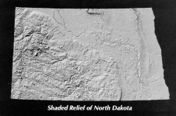
Figure 2. Shaded relief map of North Dakota. This map, published as NDGS Miscellaneous Map 32 (Luther et al., 1995), was the first NDGS product to utilize the modeling capabilities of GIS.
|
Many of the first NDGS GIS projects produced maps from previously existing spatial data sets. Early GIS projects were a cooperative effort between the NDGS and other state agencies and included production of oil well location maps, endangered species maps (with the cooperation of the ND Game and Fish Department), and legislative districts map (with the cooperation of the Secretary of State's office). Geographic Information System Center staff also made it a priority to convert existing geologic maps to a digital format. The first product to utilize the power of GIS modeling capabilities was the Shaded Relief of North Dakota map (Luther et al., 1995), created from digital elevation models from the Defense Mapping Agency (Figure 2).
Use of digital techniques spread to our active mapping programs, including STATEMAP projects. STATEMAP, a component of the National Cooperative Geologic Mapping Program, is a cooperative program providing USGS funding for geologic mapping completed by state geological surveys. The first NDGS STATEMAP project to use digital methods was the geologic mapping of the Jamestown, ND, area completed in 1994 (Biek, 1994). Three 7.5 minute quadrangles were mapped at a scale of 1:24,000. Unfortunately, the project was hampered by the lack of digital base data available at that scale. Base data, like U.S. Geological Survey digital line graphs, were available only at a scale of 1:100,000 for most areas of North Dakota at that time and only one of the three quadrangles had an existing 1:24,000 digital base. The next STATEMAP project, geologic mapping of four 7.5 minute quadrangles in the Dickinson, ND, area, was completed in 1995 (Biek and Murphy, 1995). The Dickinson project was the first NDGS mapping project to use digital techniques for final preparation of all map products.
MAP PRODUCTION PROCEDURES
Geologic mapping projects completed since the GIS Center was established have utilized an approach which combines both manual and digital techniques. The procedure has changed little since the NDGS began digital map production back in 1991. Field data are compiled on a conventional paper base map and interpreted to produce a draft geologic map. The geologic features are then drafted in ink onto a mylar positive of the base map and the inked geologic information is digitized in Arc/Info using a digitizing tablet. Features are attributed and coded to create the final digital geologic map. After review by a cartographer and the mapping geologist, the digital map is ready for release.
Final maps are available to the public as either a stand-alone, print-on-demand (POD) product or as part of a NDGS publication. The maps produced recently from STATEMAP projects have been published as open-file reports and have been printed for customers on demand. The maps are also available as digital data files upon customer request.
FUTURE MAP PRODUCTION PROCEDURES
The NDGS digital mapping program continues to evolve as new technologies and techniques become available. Desktop GIS software packages with increasing functionality and "heads-up digitizing" are an example of the new technology. In heads-up digitizing, the mapping geologist transfers field data from their field maps directly into a digital format using a desktop (or workstation) GIS software package. The NDGS recently received STATEMAP funding to begin a new geologic mapping/compilation project in northeastern North Dakota in which we intend to use ArcView v. 3.1 to enter geologic field data directly from our field maps using U.S. Geological Survey Digital Raster Graphics as a base layer. Our approach is based on that used by the Missouri Division of Geology and Land Survey (Starbuck, 1998). Heads-up digitizing eliminates the intermediate drafting and digitizing steps and should eliminate error introduced during those processes. We hope this technique will also eventually improve map-production efficiency by reducing the amount of time spent editing and reviewing the maps prior to publication.
DISCUSSION
Our shift to heads-up digitizing, desktop GIS, and POD products is in response to increased demand for digital map products and the increased number of maps we wish to publish within a limited publications budget. We must face numerous issues as the NDGS GIS Center evolves, including stability of our POD products, metadata and "version control" as we move towards greater use of desktop GIS, standardizing of map units and colors, and increasing quality within the limitations of our budget.
Stability
The greatest advantage of the POD map production process is that POD is a relatively inexpensive way to provide information to the public. In addition, storage space in our publications and map sales area is saved because of reduced inventory. Disadvantages to our current POD process include unstable media, increased waiting time for customers, and decreased quality. Currently we use a Hewlett Packard DesignJet 2000CP with standard ink jet paper. Printing sometimes takes 15 minutes or more and customers have to wait for their map to spool, print, and dry. The ink fades significantly in a relatively short time, especially if displayed in direct sunlight. The ink also has a tendency to rub off with handling and is destroyed by moisture, thereby decreasing the quality of the printout. Stability and quality can be improved by using a coated or glossy paper designed for printing high quality products. However, using a more expensive paper results in somewhat higher POD cost.
Metadata Standards and "Version Control"
The GIS Center staff recently began using a standard metadata template when constructing a new digital data set. Metadata are the documentation about the reliability and quality of the source(s) of information used to create a data set. The NDGS metadata template is based on the USGS template and complies with Federal Geographic Data Committee (FGDC) standards. Due to limited staff resources, earlier data sets were not documented with formal metadata. In some cases, little information is available to reconstruct complete metadata documents. We collect as much information as possible in these cases, and release them as "User Beware" data sets.
Use of GIS mapping techniques allows a user to quickly and easily update or change an existing data set. Although this is appealing, this speed and ease of changing data sets can also be troubling for the GIS manager, especially with increased usage of desktop GIS. At the NDGS, the most current version of a data set is stored in the GIS Center workstation, and all requests for digital information, either internal or external, must be made through the GIS manager. It is the GIS Manager's responsibility to fill that request and make sure that the user has the most current version of the data set. The data is transferred via internal network, File-Transfer-Protocol, or a copy of the file is made to CD-R or floppy disk. Desktop GIS users have the responsibility to inform the GIS manager of any changes they make to the coverages. It is hoped that this method will avoid possible duplication or accidental deletion of data sets.
Standard Map Units and Colors
We are fortunate that the geology of the entire state of North Dakota has been mapped at a reconnaissance scale of 1:125,000. The original maps were produced as part of the County Bulletin series, a cooperative effort between the NDGS, ND State Water Commission, and the U.S. Geological Survey, that took 14 geologists 23 years to complete. However, the reconnaissance maps use a different color scheme for different counties and often use different geologic names for similar geologic units. These variations in colors and units were necessary adaptations to our evolving understanding of North Dakota geology and reflect the growth of geologic knowledge, not any inadequacy of the mapping system. However, they do pose a challenge to our digital conversion efforts.
The NDGS has never established standard geologic map units and colors for geologic studies in North Dakota. Currently, three geologists on our staff are working on STATEMAP-funded projects. Each geologist creates a legend that is appropriate for the area in the state they are mapping and for potential users of the map. This lack of standardization creates problems when merging adjacent quadrangles mapped by different workers. The GIS manager, in consultation with the geologists, must reconcile the differences between the adjacent quadrangles. This is often a time-consuming process that should be avoided whenever practical.
FUTURE GOALS FOR NDGS GIS CENTER
The NDGS GIS Center will continue to evolve and grow as we expand our use of digital techniques and acquire new technology to improve our products. We have identified seven goals to help us keep pace with this rapidly growing industry. Some of these goals address the shortcomings of our existing digital mapping program. Others are intended to enhance our programs and offer additional products and services to our customers.
1. Explore printing techniques and materials to produce higher quality print-on-demand products.
If we are to continue to produce most new geologic map products as POD publications, we need to find economical ways to improve the quality and stability of these products. Their usefulness is presently limited by their lack of durability.
2. Develop and maintain metadata for all NDGS digital data sets.
Metadata need to be compiled for all existing NDGS data sets. We will continue to adhere to our standard metadata template for newly created data sets and revise this template as necessary to maintain FGDC compliance.
3. Standardize map units and colors.
The GIS Manager continues to stress the importance of standardized map unit names and colors. The geologists continue to resist standardization and deal with edge-matching problems on a case by case basis. The mapping geologists do make every attempt to reconcile their new map with adjacent, preexisting maps. However, each geologist brings their own unique perspective to interpreting field observations. They prefer to create objectively defined units that suit the particular mapping application, rather than pigeon-holing their observations into a predetermined standard.
4. Digitize all out-of-print maps and place them on the world wide web.
In the past, a number of customers have requested out-of-print maps. Currently, the best we can do is to refer them to the NDGS Library, the State Library, or a university library. As the use of digital data becomes more common, having out-of-print maps in digital format will be beneficial to not only our own agency, but also to other agencies, such as the State Health Department, State Historical Society, ND Game and Fish Department, and State Water Commission.
5. Explore combined capabilities of GIS and stratigraphic software packages (PetraTM).
The NDGS recently purchased PetraTM, an integrated database and stratigraphic software program. The full potential of this new software package combined with GIS software is yet to be explored at the NDGS. There are great potential benefits to all aspects of our research, including petroleum exploration, oil and gas reservoir estimates, geologic mapping, lignite reserve estimates, and other economic geology applications.
6. Hire an IT/GIS Analyst.
An additional person with training and extensive experience in computer networking, database management, and GIS management is necessary for the continued successful operation of the NDGS GIS Center. Currently, general computer maintenance is performed by an NDGS geologist who happens to be very interested and knowledgeable about computers. Computer maintenance costs could be substantially reduced by hiring an IT/GIS analyst to take over these duties from a staff geologist. The NDGS has requested funding for this position, but at the time of this writing, it remains to be seen if funding will be approved by the state legislature.
7. Decrease turnaround time for map products.
With the addition of GIS staff and the use of ArcView, it is hoped that turnaround time for map production will be reduced. This will enable us to quickly produce maps dealing with time-sensitive issues, like flooding or land-use changes, and make our agency's products more visible to the public and legislators.
CONCLUSION
The use of digital mapping techniques at the NDGS has greatly enhanced our mapping capabilities. Digital methods allow us to produce print-on-demand map products that can be updated as new data become available or customized to serve a specific user need. This flexibility enables us to better serve our customers, whether they are trained geologists, engineers, land-use planners, or the general public. However, there is always room to improve. We recognize the problems in our current approach, particularly with regard to product stability and standardization. New technologies continually become available to simplify or streamline digital processes, new applications of digital mapping are created, and new methods of integrating diverse data are constantly being developed. We hope that, by critically examining our current system and participating in events like this Workshop on Digital Mapping Techniques, we can direct our growth to make the best use of limited resources while maintaining our high quality standards.
REFERENCES
Biek, R., 1994, Geology of the Jamestown, Bloom, and Spiritwood Lake Quadrangles, Stutsman County, North Dakota: NDGS Open-File Report 94-1, 62p., 6 pl., 1:24,000 scale.
Biek, R., and Murphy, E., 1995, Geology of the Davis Buttes, Dickinson North, Dickinson South, and Lehigh Quadrangles, Stark and Dunn Counties, North Dakota: NDGS Open-File Report 95-1, 64 p., 9 pl., 1:24,000 scale.
Luther, M., Bassler, R., and Jirges, H., 1995, Shaded Relief of North Dakota: NDGS Miscellaneous Map 32, 1 pl., 1:1,000,000 scale.
Starbuck , E., 1998, Digital geologic mapping at the Missouri Division of Geology and Land Survey using ArcView 3 and USGS Digital Raster Graphics; in Soller, D.R., ed., Digital Mapping Techniques '98 - Workshop Proceedings: U.S. Geological Survey Open-File Report 98-487, p. 103-104, URL https://pubs.usgs.gov/openfile/of98-487/brief.html.
Vonderohe, A.P., Gurda, R.F., Ventura, S.J., and Thum, P.G., 1991, Introduction to Local Land Information Systems for Wisconsin's Future: Wisconsin State Cartographer's Office, Madison, Wisconsin, 59 p.