U.S. Geological Survey
Box 25046
Denver Federal Center, MS 913
Denver, CO 80225
Telephone: (303) 236-1320
Fax: (303) 236-0214
e-mail: rwahl@usgs.gov
In August 1996, in St. Louis, Missouri, the Digital Geologic Mapping Committee of the Association of American State Geologists (AASG) and NGMDB of the USGS, formed several working groups to devise standards and guidelines for various concepts that make up a geologic map in digital form. Information about these working groups is available at the NGMDB project web site, http://ncgmp.usgs.gov/ngmdbproject/. One element of the geologic map database standards effort that has had little attention is map geometry.
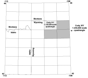
Figure 1. The Greater Yellowstone Area. |
The NGMDB has the opportunity to test the results of its standards efforts on a database that is needed in the region by various interest groups, and that when integrated with other geospatial data sets of the GYA will prove to be vital for ecosystem management there. However, to insure the continued usefulness of the database, the geologic data in the database must be updatable and the GIS system must be able to keep careful track of the revisions as they are made. In addition, digital map databases from the state geological surveys of Idaho, Montana, and Wyoming will be integrated into the database. Each state survey will most likely have different ways of representing the geometry of their products.
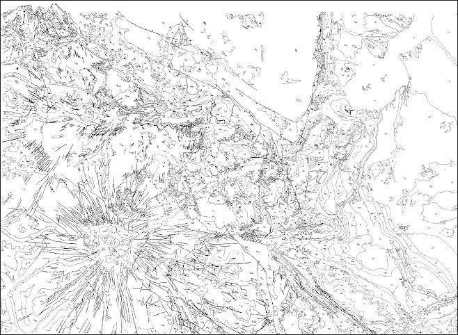
Figure 2. The Cody, Wyoming 1:100,000-scale geologic map.
|
The Cody, WY 1:100,000-scale geologic map data exists as a film positive that was compiled by W.G. Pierce (1997) for the geologic map of the Cody 2-degree quadrangle (figure 2). Time constraints preclude the use of the seven published 15' geologic quadrangle maps as the primary source materials for the 1:100,000-scale map. The three other 1:100,000-scale pieces of the Cody 2-degree sheet are also unpublished and exist only as film positives. Large-scale source materials for these maps have yet to be located.
It is clear, that although geospatial data can be transferred using standard transfer formats, the representation of geospatial objects such as polygons and lines contained in a digital geologic map database is not standardized.
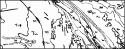
Figure 3. Linework near Pat O�Hara Mountain, southern part of the Cody, WY 1:100,000-scale map. |
In studying the data from this locale on the Cody quadrangle, I conclude that there are no standard ways to represent linear data with characteristics more subtle than the primary attributes of "contact" or "fault". An implicit assumption is made for rock units older (or different) from Quaternary alluvium, that lines attributed as contacts show the top of one formation and the bottom of another. This information is indirectly found in age attributes in the data model. But what happens if the ages that are given for two formations are both "lower Cretaceous" and they are in contact in one place but not in another on the same map? I suggest that lines labeled as contacts be labeled in addition with other information that would add geologic and geometric attributes such as "unit top" or "unit bottom".
Another related question has arisen while capturing the Cody geology. The lines were automatically generated from a cleaned-up raster scan file by LT4X, a raster-to-vector conversion package used currently by the USGS-NMD. To reduce the angularity of such lines, the final vector data set was smoothed using B-splines. The result was that, after the import into Arc/Info, the lines representing contacts, faults, or dikes that had shown the slightest "wiggle" in them as raster lines had too many vertices. However, at map scale, the lines look "good" or smooth.
I am experimenting with the "GENERALIZE" and "SPLINE" commands in Arc/Info. I use the "GENERALIZE" command to eliminate the extra vertices in faults and dikes; and the "SPLINE" command with an appropriate value for the grain tolerance along with the "GENERALIZE" command with the "BENDSIMPLIFY" option to eliminate extraneous vertices in contacts. I am also experimenting with values for the "line simplification distance" option and the grain tolerance. Careful use of the "GENERALIZE" command and the "SPLINE" command should produce smooth contact lines and straight faults and dikes that matches the original linework of the author.
Lastly, in some places, rock units that were mapped separately on the 15' geologic source maps are combined when the outcrops of individual units are too small to be seen at 1:100,000. I have left them as Pierce compiled them. I have done this so that the "art", which is only partially map esthetics, and his geologic concepts would be kept intact.
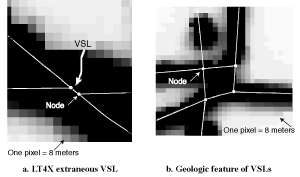
Figure 4. Very short lines shown over original raster scan. |
The choice of 50 meters for a VSL was in origin a choice based on experience. I have learned since that the NMAS (USBB, 1947) document specifies that 90% of all objects shall be within 1/50th of an inch of the true position when placing objects on a map at a scale smaller than 1:20,000. This corresponds to 50.8 meters at a scale of 1:100,000. A point of confusion may arise because USGS-NMD uses similar terms in the Federal Geographic Data Committee (FGDC, 1998) metadata standard as follows:
In addition, the Geography Department at the University of California at Santa Barbara (UCSB) teaches a concept called "map resolution" in their GIS classes. UCSB defines map resolution to be linear distance below which objects cannot be accurately located relative to other objects on a map of a given scale. The rule of thumb taught to UCSB students is as follows:
(Map scale denominator) / 2*1000 = map resolution, in meters.
Then, map resolution would be 50 meters for a 1:100,000-scale map, and 12 meters for a 1:24,000-scale map. More recently, NMD states in the map revision document (USGS-NMD, 1998) that locations of revisions to preexisting maps especially from aerial photography may be in error by as much as 22.2 meters (forty feet) of its actual position on a 1:24,000-scale map. If this is scaled for a 1:100,000-scale map, this positional inaccuracy might be as large as 88.8 meters. Moreover, one might argue that the digital geologic map layer is a revision or an addition to a preexisting map, the topographic map. In this case, the accuracy with which digital geology can be located on 1:100,000-scale topographic base maps may be on the order of 100 meters.
The understanding or lack thereof about these foregoing concepts in this section by the geologic mapping community has great consequences for digital geologic map compilation and its subsequent use as a thematic map layer.
Mappers that I know usually delete rock outcrops that show as a point unless such features are a topographically or geologically important feature. They then "cartoon in" a line or polygon to represent these features. However, Reynolds (1971) used small triangles to indicate formation outcrops that were too small to show on a 1:24,000-scale map. The locations of these outcrops were important data that show the reason that inferred unit contacts were drawn as shown on the map. It is not possible with most GIS systems to use point data formats to represent spatial features in a layer with polygon or line data. For example, any attempt to include data points in an Arc/Info coverage that contains polygon and line data results in problems if one issues a "BUILD" or "CLEAN" command. All of the data points then become label points, and the effect of these commands cannot be undone.
Digital geologic map analysts prefer polygon and line data in the same coverage while working in Arc/Info. However, a "casual" user of ArcView who imports such a map coverage will be surprised to learn that strictly line information may be left behind. In ArcView, line data and polygon data cannot exist in the same file. Other GIS systems do not allow attribution of polygon boundaries with more that one attribute. A line that is a polygon boundary cannot also be a fault in these cases.
The preceding discussion becomes more complex when one looks at existing and proposed standards for the simple geometric terms: polygon and line. The definitions of these terms differ among software vendors and standards organizations. The interested reader can look at some of the various standards listed below:
A possible solution to these problems comes first from asking the question: What type of spatial data geometric objects do modern GIS systems handle best? In my opinion, these systems handle polygons, of whatever type, best. Then notice that USGS-NMD publishes point data in DLG files by including points as lines composed of two vertices that lie on top of one another. These two ideas lead to a further idea that would allow the representation of both point and linear features as polygons.
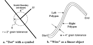
Figure 5. Point and line objects captured as polygons. |
Extending the idea to two dimensions (a line), imagine a linear feature that is enclosed by a "flexible" rectangle whose width would be four times the grain tolerance with the line representing the linear feature running down the center of the rectangle (figure 5b). This would make two polygons, one on either side of the central line that could be labeled "right" and "left" to show the direction that the line should be traversed. I would call this construct a "wire". Problems would arise with the implementation of such constructs, but they would allow point and linear features to be carried in the same coverage in all GIS systems. A wire would allow a linear feature to be clipped and still keep the directional information intact. Linear feature decoration would be applied to the central line without interruption. The perimeter of the wire could be a scratch boundary when necessary. Unfortunately the "Dynamic Segmentation" feature of Arc/Info that would perform most of the same functions is proprietary and does not directly allow an import into other GIS systems.
The wire construct would be of great value in the geologic map database of the GYA, because there are five different forms that dikes are recorded on geologic maps here (I am including sills in this discussion). They are:
The wire construct would allow the geometric relations of linear features like dikes and sills of the first three types to be kept in the geometry. The fourth and fifth dike types can at present best be shown as overlay polygons in another coverage. The number of dikes on the Cody 1:100,000-scale map alone discourages the recording of individual geometric relations in an attribute relations table. Such relationships might be more easily recorded in a form that is useable in a digital manner as a part of the spatial geometry of the coverage.
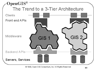
Figure 6. Three-tiered data delivery, with their Applications Programming Interfaces (APIs). |
Translating software may be necessary in between each of the three tiers, using the main software systems application programming interfaces (APIs) shown in figure 6, to allow data to move smoothly from one of the tiers to another. With the advent of such systems and the likelihood of GIS data holders moving to this kind of a data archive, the spatial data produced by the geologic community must be in such a form that it will readily be useful in such an environment. This form includes an understanding of the geometric aspects of their products.
The future of the geologic database may be with Arc/Info version 8 on Windows NT systems using object models or with GIS systems like SmallWorld or even by the use of polygons to represent all geologic information in current GIS systems. A continuing study of current spatial geometry standards by one of the current AASG/USGS working groups or a new working group is needed to see how these spatial geometries fit the needs of digital geologic maps. Clearly much remains to be done to standardize digital geologic map geometry.
OpenGIS, 1999, http://www.opengis.org/techo/presentations/overview/side063.htm.
OpenGIS, 1998, http://www.opengis.org/techno/specs.htm (click on Topic 1).
Pierce, W.G., 1997, Geologic map of the Cody 1-degree by 2-degree quadrangle, northwestern Wyoming: U.S. Geological Survey Miscellaneous Investigations I-2500, scale 1:250,000.
Reynolds, Mitchell W., 1971, Geologic map of the Bairoil quadrangle, Sweetwater and Carbon counties, Wyoming: U.S. Geological Survey GQ-913, scale 1:24,000.
Raines, Gary L., and Hastings, Jordan T., 1999, Curly: Unpublished software tool produced under the auspices of the AASG/USGS geologic map data model working group, available at: http://geology.usgs.gov/dm/tools/Curly/.
US Bureau of the Budget (USBB), 1947, National Map Accuracy Standards: http://rockyweb.cr.usgs.gov/nmpstds/nmas.html.
USGS-NMD, 1998, Standards for revised primary series quadrangle maps (Draft for implementation): http://rockyweb.cr.usgs.gov/nmpstds/qmapstds.html.
|
Return to Table of Contents
This site is https://pubs.usgs.gov/openfile/of99-386/wahl.html
|