
 half
meter bathymetry contours offshore Sarasota, FL
half
meter bathymetry contours offshore Sarasota, FL
Metadata:
-
Identification_Information:
-
Citation:
-
Citation_Information:
-
Originator: Dave Twichell(comp.)
-
Publication_Date: 19990601
-
Title: half meter bathymetry contours offshore Sarasota, FL
-
Publication_Information:
-
Publication_Place: Woods Hole Field Center
-
Publisher: USGS, Coastal and Marine Geology Team
-
Description:
-
Abstract:
-
The U.S. Geological Survey, in cooperation with the University of South
Florida and Eckerd College, completed a bathymetric, sidescan sonar, high-resolution
seismic-reflection, and surface sediment sampling survey of the inner shelf
environment along the western Florida coast. The survey area extends 15km
from Sarasota Point to Buttonwood Harbor. This study is part of a larger
program initiated by the U.S. Geological Survey to map the geologic framework
and monitor the modern processes that affect the western Florida coastal
zone. This portion of the project included a reconnaissance high-resolution
seismic and side-scan sonar surveys of the entire study area, detailed
mapping to identify patterns of hard grounds and sediment cover, and coring
of sediments to document historical development of the inner shelf and
coastal system.
-
Purpose:
-
This GIS overlay is a component of the Sarasota, Florida ArcView GIS database
and contains the computer generated half meter bathymetry contours for
the Sarasota study area.
-
Supplemental_Information:
-
Isobath contours range from 3.5 to 12m. Depth values were recorded in decimeters
to provide somewhat more data resolution in the shallow field study. Because
values are recorded in decimeters a depth value of 80 would be equivalent
to a depth of 8.0m.
-
Time_Period_of_Content:
-
Time_Period_Information:
-
Range_of_Dates/Times:
-
Beginning_Date: 19940502
-
Ending_Date: 19940508
-
Currentness_Reference: Ground Condition
-
Status:
-
Progress: Complete
-
Maintenance_and_Update_Frequency: None planned
-
Spatial_Domain:
-
Bounding_Coordinates:
-
West_Bounding_Coordinate: -82.7306
-
East_Bounding_Coordinate: -82.5686
-
North_Bounding_Coordinate: 27.3855
-
South_Bounding_Coordinate: 27.2178
-
Keywords:
-
Theme:
-
Theme_Keyword_Thesaurus: General
-
Theme_Keyword: U.S. Geological Survey
-
Theme_Keyword: Woods Hole Field Center
-
Theme_Keyword: R/V BELLOWS
-
Theme_Keyword: BLWS 95-04
-
Theme_Keyword: May 2-8, 1995
-
Theme_Keyword: vector
-
Theme_Keyword: complete chain
-
Theme_Keyword: ArcView
-
Theme_Keyword: shapefile
-
Theme_Keyword: bathymetry contours
-
Theme_Keyword: isobath
-
Theme_Keyword: half meter
-
Theme_Keyword: .5m
-
Theme_Keyword: .5 meter
-
Theme_Keyword: half meter contours
-
Theme_Keyword: .5 meter contours
-
Theme_Keyword: .5m contours
-
Theme_Keyword_Thesaurus: PrincipalInvestigators
-
Theme_Keyword: David C. Twichell
-
Theme_Keyword: Guy Gelfenbaum
-
Place:
-
Place_Keyword_Thesaurus: General
-
Place_Keyword: Gulf of Mexico
-
Place_Keyword: Florida
-
Place_Keyword: West Florida shelf
-
Place_Keyword: Sarasota
-
Place_Keyword: Big Sarasota Pass
-
Place_Keyword: Longboat Key
-
Place_Keyword: Buttonwood Harbor
-
Place_Keyword: New Pass
-
Place_Keyword: Lido Key
-
Access_Constraints: None
-
Use_Constraints:
-
The U.S. Geological Survey must be referenced as the originator of the
dataset in any future products or research derived from these data.
-
Point_of_Contact:
-
Contact_Information:
-
Contact_Organization_Primary:
-
Contact_Organization: U. S. Geological Survey
-
Contact_Person: Dave Twichell
-
Contact_Position: Oceanographer
-
Contact_Address:
-
Address_Type: mailing and physical address
-
Address: 384 Woods Hole Road
-
City: Woods Hole
-
State_or_Province: MA
-
Postal_Code: 02532
-
Country: USA
-
Contact_Voice_Telephone: (508) 548-8700 x2266
-
Contact_Facsimile_Telephone: (508) 457-2310
-
Contact_Electronic_Mail_Address: dtwichell@usgs.gov
-
Browse_Graphic:
-
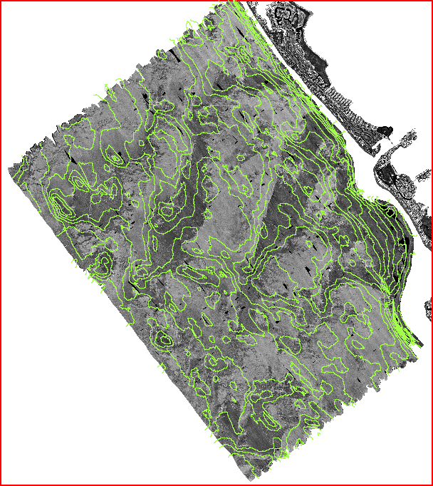
Browse_Graphic_File_Name: htmldocs/images/covrgs/halfm.gif
-
Browse_Graphic_File_Description: GIF
-
Browse_Graphic_File_Type: .5m bathymetry contours overlaid on sidescan
sonar mosaic
-
Native_Data_Set_Environment: ESRI Shapefile format
-
Data_Quality_Information:
-
Logical_Consistency_Report: .
-
Completeness_Report: .
-
Lineage:
-
Process_Step:
-
Process_Description:
-
Depth measurements were collected along the ship's track and corrected
for tide changes. Because the survey area was in a shallow area off shore
of Sarasota, the depth ranges were approximately 3m to 12m. The depth values
were recorded in decimeters (i.e a value of 85 equals 8.5m) to provide
some additional accuracy and still keep the values within an 8-bit data
range. The depth information was imported into PCI Remote Sensing software
and a n 8-bit image was created. That data (image) was gridded to create
a seafloor surface image and .5m contours were drawn through the image
using the PCI Xpace program CONTOUR.
-
Process_Date: Unknown
-
Source_Produced_Citation_Abbreviation: .5m Sarasota bathymetry contours
-
Process_Contact:
-
Contact_Information:
-
Contact_Person_Primary:
-
Contact_Person: Dave Twichell
-
Contact_Organization: U.S. Geological Survey
-
Contact_Position: Oceanographer
-
Contact_Address:
-
Address_Type: mailing and physical address
-
Address: 384 Woods Hole Road
-
City: Woods Hole
-
State_or_Province: MA
-
Postal_Code: 02543-1598
-
Country: USA
-
Contact_Voice_Telephone: (508) 548-8700 x2266
-
Contact_Facsimile_Telephone: (508) 457-2310
-
Contact_Electronic_Mail_Address: dtwichell@usgs.gov
-
Spatial_Data_Organization_Information:
-
Direct_Spatial_Reference_Method: Vector
-
Point_and_Vector_Object_Information:
-
SDTS_Terms_Description:
-
SDTS_Point_and_Vector_Object_Type: Complete chain
-
Point_and_Vector_Object_Count: 274
-
Spatial_Reference_Information:
-
Vertical_Coordinate_System_Definition:
-
Depth_System_Definition:
-
Depth_Datum_Name: Mean low water
-
Depth_Resolution: .25
-
Depth_Distance_Units: Meters
-
Depth_Encoding_Method: Attribute values
-
Entity_and_Attribute_Information:
-
Detailed_Description:
-
Entity_Type:
-
Entity_Type_Label: halfm.dbf
-
Entity_Type_Definition: Shapefile Attribute Table
-
Entity_Type_Definition_Source: None
-
Attribute:
-
Attribute_Label: Depth
-
Attribute_Definition: Depth, in decimeters, of bathymetry contour
interval.
-
Attribute_Definition_Source: User Defined
-
Attribute_Domain_Values:
-
Range_Domain:
-
Range_Domain_Minimum: 35
-
Range_Domain_Maximum: 120
-
Attribute:
-
Attribute_Label: Interval
-
Attribute_Definition:
-
a text string to identify the contour internval. Because depth values are
in decimeters this field was added to allow labeling of contour lines with
a proper label. For example, the interval value for contour line with a
depth 65 is -6.5
-
Attribute_Definition_Source: User Defined
-
Attribute_Domain_Values:
-
Unrepresentable_Domain: Character field
-
Distribution_Information:
-
Distributor:
-
Contact_Information:
-
Contact_Organization_Primary:
-
Contact_Organization: U. S. Geological Survey
-
Contact_Person: Dave Twichell
-
Contact_Position: Oceanographer
-
Contact_Address:
-
Address_Type: mailing and physical address
-
Address: 384 Woods Hole Road
-
City: Woods Hole
-
State_or_Province: MA
-
Postal_Code: 02543
-
Country: USA
-
Contact_Voice_Telephone: (508) 548-8700 x2266
-
Contact_Facsimile_Telephone: (508) 457-2310
-
Contact_Electronic_Mail_Address: dtwichell@usgs.gov
-
Resource_Description: half meter bathymetry contour lines of Sarasota,
FL study area
-
Distribution_Liability:
-
Although this derived data set has been used by the USGS, no warranty,
expressed or implied, is made by the USGS as to the accuracy of the data
and/or related materials. The act of distribution shall not constitute
any such warranty, and no responsibility is assumed by the USGS in the
use of these data or related materials.
-
Standard_Order_Process:
-
Digital_Form:
-
Digital_Transfer_Information:
-
Format_Name: ARCE
-
File_Decompression_Technique: No compression applied
-
Transfer_Size: 11,137Kb
-
Digital_Transfer_Option:
-
Offline_Option:
-
Offline_Media: CD-ROM
-
Recording_Capacity:
-
Recording_Density: 650
-
Recording_Density_Units: Mbytes
-
Recording_Format: ISO 9600
-
Compatibility_Information:
-
The user must have a CD-ROM capable of reading an ISO 9660 standard CD-ROM.
-
Digital_Form:
-
Digital_Transfer_Information:
-
Format_Name: ARCE
-
Format_Specification: ARC/INFO export format (*.e00)
-
File_Decompression_Technique: No compression applied
-
Transfer_Size: 20,142Kb
-
Digital_Transfer_Option:
-
Offline_Option:
-
Offline_Media: CD-ROM
-
Recording_Capacity:
-
Recording_Density: 650
-
Recording_Density_Units: Mbytes
-
Recording_Format: ISO 9600
-
Compatibility_Information:
-
The user must have a CD-ROM capable of reading an ISO 9660 standard CD-ROM.
-
Digital_Form:
-
Digital_Transfer_Information:
-
Format_Name: ASCII
-
Format_Information_Content:
-
The ASCII file contains vector line segments. Line segments begin with
a record containing LINE xx where xx is the assigned integer value of the
depth contour. The depth contour value is assigned in decimeters. For example
a value of 35 would be equivalent to 3.5m. The line information follows
with coordinate pairs on a single line/record. Coordinates are recorded
in signed decimal degrees and are in X,Y order (lon/lat).
-
File_Decompression_Technique: No compression applied
-
Transfer_Size: 22,223Kb
-
Digital_Transfer_Option:
-
Offline_Option:
-
Offline_Media: CD-ROM
-
Recording_Capacity:
-
Recording_Density: 650
-
Recording_Density_Units: Mbytes
-
Recording_Format: ISO 9600
-
Compatibility_Information:
-
The user must have a CD-ROM capable of reading an ISO 9660 standard CD-ROM.
-
Digital_Form:
-
Digital_Transfer_Information:
-
Format_Name: ARCV
-
Format_Information_Content: All required ArcView shapefiles zipped
as one file.
-
File_Decompression_Technique: zip
-
Transfer_Size: 5,943Kb
-
Digital_Transfer_Option:
-
Offline_Option:
-
Offline_Media: CD-ROM
-
Recording_Capacity:
-
Recording_Density: 650
-
Recording_Density_Units: Mbytes
-
Recording_Format: ISO 9600
-
Compatibility_Information:
-
The user must have a CD-ROM capable of reading an ISO 9660 standard CD-ROM.
-
Fees: None
-
Technical_Prerequisites:
-
Bathymetry contours are available in three formats 1- ArcView shapefile;
2 - ARC export; 3- ASCII text format. The user must have ESRI's ArcView
or ARC program or another GIS application package capable of importing
those data formats. The ASCII format can be read by any text editor.
-
Metadata_Reference_Information:
-
Metadata_Date: 19990603
-
Metadata_Contact:
-
Contact_Information:
-
Contact_Organization_Primary:
-
Contact_Organization: U. S. Geological Survey
-
Contact_Person: Valerie Paskevich
-
Contact_Position: Computer Specialist
-
Contact_Address:
-
Address_Type: mailing and physical address
-
Address: 384 Woods Hole Rd.
-
City: Woods Hole
-
State_or_Province: MA
-
Postal_Code: 02543
-
Country: USA
-
Contact_Voice_Telephone: (508) 548-8700 x2281
-
Contact_Facsimile_Telephone: (508) 457-2310
-
Contact_Electronic_Mail_Address: vpaskevich@usgs.gov
-
Metadata_Standard_Name: FGDC Content Standards for Digital Geospatial
Metadata
-
Metadata_Standard_Version: CSDGM version 2
-
Metadata_Time_Convention: Local time
-
Metadata_Access_Constraints: None
-
Metadata_Use_Constraints: None
Generated by mp
on Fri Jun 4 08:29:36 1999