
Isostatic Gravity Map of the Las Vegas 30 x 60 Minute Quadrangle, California and Nevada
by V.E. Langenheim1, R.L. Morin1, J.G. Davidson1, K.M. Schmidt1, and H.R. Blank, Jr.2
U.S. Geological Survey Open-File Report 99-398
Version 1.0
1999
U.S. DEPARTMENT OF THE INTERIOR
BRUCE BABBITT, Secretary
U.S. GEOLOGICAL SURVEY
Charles G. Groat, Director
This report is preliminary and has not been reviewed for conformity with U.S. Geological Survey (USGS) editorial standards or with the North American Stratigraphic Code. Any use of trade, firm, or product names is for descriptive purposes only and does not imply endorsement by the U.S. Government.
1 345 Middlefield Road, MS 975, Menlo Park, CA 94025
2 W 904 Riverside Avenue, Spokane, WA 99201

View the map as a PDF
The report is provided as a PDF file for which you will need Adobe Acrobat Reader 4.0 or higher to view. If you are using version 3.01 or lower, you will need to upgrade to view this map because the map is wider than the 46-inch limit on 3.01. You can download a copy of the latest version (4.0 at the time of this publication) by clicking the button above. This map can be printed on plotters that use paper at least three feet wide (for example, HP 2500). The map is 52.5" wide and 30" long.
CLICK HERE To view the PDF file (of99-398.pdf) (3.6 MB).
Introduction
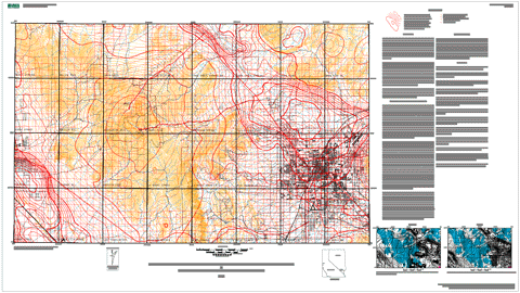
This isostatic residual gravity map is part of the Las Vegas Urban Corridor mapping project and is intended to promote further understanding of the geology in the Las Vegas 30 x 60 minute quadrangle, Nevada, by serving as a basis for geophysical interpretations and by supporting both geological mapping and topical (i.e., hydrologic) studies. Local spatial variations in the Earth's gravity field (after various corrections for elevation, terrain, and deep crustal structure explained below) reflect the distribution of densities in the mid- to upper crust. Densities often relate to rock type, and abrupt spatial changes in density commonly mark lithologic boundaries. Basement rocks exposed within the Las Vegas quadrangle include Paleozoic carbonate and siliciclastic rocks exposed in the mountainous areas of the quadrangle and produce many of the positive anomalies. The highest densities measured on the Las Vegas quadrangle are from Precambrian gneiss exposed on the western edge of Frenchman Mountain (latitude 36° 11' N, longitude 115° 01' W) and Paleozoic dolomites exposed in the Spring Mountains (Langenheim and others, 1998). Alluvial sediments, usually located in the valleys, and Tertiary sedimentary and volcanic rocks are characterized by low densities. However, with increasing depth of burial and age, the densities of these rocks may become indistinguishable from those of basement rocks. Isostatic residual gravity values within the Las Vegas quadrangle range from about -33 mGal over the sedimentary basins of the Las Vegas (centered over the Gass Peak SW quadrangle) and Pahrump (southwest corner of quadrangle) Valleys to about +25 mGal near Mt. Charleston in the west-central part of the map.
Data
Following are links to information about the data (metadata) and the data themselves.
Explanation of principal fact format
The digital dataset consists of one file (lv100k.iso) containing
the 2,506 point data used to create the map. The file contains the principal
facts of the gravity stations, with one point coded per line.
The format of the data is described below.
CLICK HERE view the explanation of principal fact format (readme-of99-398.txt; 33 KB).
Metadata
CLICK HERE view the metadata in text format (of99-398-meta.txt; 17 KB).
Download the digital data and map
The digital data and map for this publication are available on this server as the file lv100k.iso.
CLICK HERE to download lv100k.iso (231 KB).
View the version history
CLICK HERE view the version-history file for this report.
To contact the senior author, email Victoria Langenheim (zulanger@usgs.gov).
The URL of this page is https://pubs.usgs.gov/of/1999/of99-398/
Date created: 10/19/1999
Last modified: 6/6/2005 (mfd)
Email technical-support comments to
Mike Diggles (mdiggles@usgs.gov).