| This is a cover page. To go to the actual document, click on the title above. |
| The document is in PDF format (1,234 KB). You will need Acrobat Reader to view and print. If you do not have Adobe Acrobat Reader, you will need to download the program. |
| Click here to Download Acrobat Reader and follow the download and installation instructions provided. |
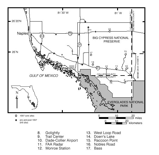
In 1997, ten cores were drilled in eastern Collier County and northern Monroe County, within the limits of the Big Cypress National Preserve. These cores represent a continuation of the study of seven cores in western Collier County begun in 1996 and reported in Weedman and others (1997) and Edwards and others (1998). This joint U.S. Geological Survey and Florida Geological Survey project is designed to acquire subsurface geologic and hydrologic data in southwest Florida to extend current ground-water models, thereby expanding the utility of these models for land and water management. In this report we describe the lithostratigraphy, geophysical logging, sedimentological analysis, dinocyst biostratigraphy, and strontium-isotope stratigraphy of these ten cores.
The three geophysical logs (natural gamma-ray, induction conductivity, and neutron porosity) assumed to be related to formation lithology and water quality show that a number of clay-rich zones are present in all of the boreholes, and that pore-water conductivity increases with depth. The clay-rich zones are confirmed by visual examination of core material and sedimentological analysis.
The relative transmissivity calculated at 10-foot-thick intervals shows that in six of the boreholes, high values are associated with the shallow aquifer in the 0-40 ft interval. Two of the boreholes (the most northerly and the most easterly) showed relatively higher values of transmissivity in permeable zones at or somewhat below 100 ft in depth. Core geology and logs indicate that the deeper aquifers are not more permeable than similar deeper zones in the other boreholes, but rather that the shallow aquifer appears to be less permeable in these two coreholes.
The Arcadia (?) Formation was only penetrated in the deepest core where it is late Miocene in age. The Peace River Formation was penetrated in all but the two westernmost cores. It yields a late Miocene age, based on both dinocysts and strontium-isotope stratigraphy. The top is an irregular surface. Age and stratigraphic relations suggest that the upper part of the Peace River and lower part of the unnamed formation are at least partially equivalent laterally.
The unnamed formation was recovered in every core. It is thinnest in the northernmost core and thickest to the west. Ages calculated from strontium isotopes range from 6.9 to 4.6 million years ago (late Miocene to early Pliocene). The top of the unnamed formation is deepest to the north and it becomes shallower to the southwest.
The Tamiami Formation also was recovered in every core and consistently yields early Pliocene ages; it yields late Pliocene ages near the top in two cores. The age and lateral relations strongly suggest that the lower part of the Tamiami Formation and the upper part of the unnamed formation are lateral facies of each other.
The Fort Thompson (?) Formation, Miami Limestone, and undifferentiated siliciclastic sediments and limestone at the very top of the cores were not dated.
This report is preliminary and has not been reviewed for conformity with U.S. Geological Survey editorial standards or with the North American Stratigraphic Code. Any use of trade, product, or firm names is for descriptive purposes only and does not imply endorsement by the U.S. Government.
| Information for ordering U.S. Geological Survey maps and reports is available by calling 1-888-ASK-USGS. Information for ordering USGS products also is available from the USGS home page on the World Wide Web at URL http://www.usgs.gov/. You can write to USGS Information Services E-mail: infoservices@usgs.gov Fax: 303-202-4695 |
Return to Eastern Earth Surface Processes Team
Return to Publications Warehouse
Return to Geologic Information