
By W.E. Scott, R.M. Iverson, S.P. Schilling, and B.J. Fisher
Vancouver, Washington
2001
U.S. DEPARTMENT OF THE INTERIOR
Bruce Babbitt,
Secretary
U.S. GEOLOGICAL SURVEY
Charles G. Groat,
Director
This report is preliminary and has not been reviewed
for conformity with U.S.
Geological Survey (USGS) editorial standards or with
the North American
Stratigraphic Code. Any use of trade, firm, or product
names is for descriptive
purposes only and does not imply endorsement by the
U.S. Government.
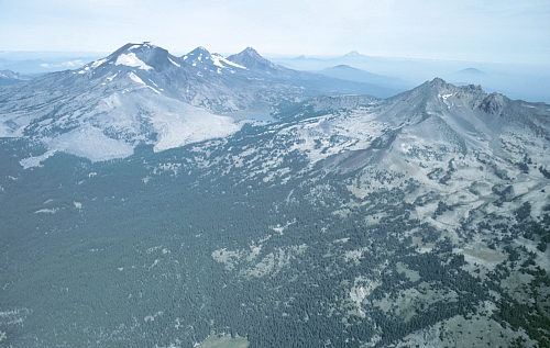
Aerial view from southeast of Three Sisters volcanic center (South, Middle, and North Sister left of center; Broken Top right of center). Light colored areas on south flank of South Sister are 2,000-yr-old lava flows. Much of area on lower flanks of Broken Top is mantled by pumice and ash erupted just prior to emplacement of these lava flows. Photo by William E. Scott, USGS
Three Sisters is one of three potentially active volcanic centers that lie close to rapidly growing communities and resort areas in Central Oregon. Two types of volcanoes exist in the Three Sisters region and each poses distinct hazards to people and property. South Sister, Middle Sister, and Broken Top, major composite volcanoes clustered near the center of the region, have erupted repeatedly over tens of thousands of years and may erupt explosively in the future. In contrast, mafic volcanoes, which range from small cinder cones to large shield volcanoes like North Sister and Belknap Crater, are typically short-lived (weeks to centuries) and erupt less explosively than do composite volcanoes. Hundreds of mafic volcanoes scattered through the Three Sisters region are part of a much longer zone along the High Cascades of Oregon in which birth of new mafic volcanoes is possible.
This report describes the types of hazardous events that can occur in the Three Sisters region and the accompanying volcano-hazard-zonation map outlines areas that could be at risk from such events. Hazardous events include landslides from the steep flanks of large volcanoes and floods, which need not be triggered by eruptions, as well as eruption-triggered events such as fallout of tephra (volcanic ash) and lava flows. A proximal hazard zone roughly 20 kilometers (12 miles) in diameter surrounding the Three Sisters and Broken Top could be affected within minutes of the onset of an eruption or large landslide. Distal hazard zones that follow river valleys downstream from the Three Sisters and Broken Top could be inundated by lahars (rapid flows of water-laden rock and mud) generated either by melting of snow and ice during eruptions or by large landslides. Slow-moving lava flows could issue from new mafic volcanoes almost anywhere within the region. Fallout of tephra from eruption clouds can affect areas hundreds of kilometers (miles) downwind, so eruptions at volcanoes elsewhere in the Cascade Range also contribute to volcano hazards in Central Oregon.
This report is intended to aid scientists, government officials, and citizens as they work together to reduce the risk from volcano hazards through public education and emergency-response planning.
The full report is online below. The map (plate 1) is in PDF. The report is also available in PDF. To view the full report or map as a PDF you will need Adobe Acrobat reader. You can download a copy of the latest version by clicking the Acrobat Reader icon.
![]()
To view the PDF of the report, of99-437.pdf, CLICK HERE
(960 KB)
To view the PDF of the map (plate 1), of99-437map.pdf,
CLICK
HERE (3,833 KB)
Paper copies of the report (including a black & white version of the Hazards Zonation Map, plate 1) are also available from the U.S. Geological Survey, Information Services, P.O. Box 25286, Denver, CO, 80225, (303) 202-4210.
Two types of volcanoes
Hazardous events at composite volcanoes
Hazardous events at mafic volcanoes
Proximal hazard zone
Distal hazard zones
McKenzie River valley
Upper Deschutes River valley
Tumalo Creek valley
Squaw Creek valley
Regional lava-flow hazard zone
Tephra hazard zones
Protecting our communities and ourselves from volcano hazards
Figure 1. Regional setting of Three Sisters region
Figure 2. Hazardous events at composite volcanoes
Figure 3. Volcanic activity in the Three Sisters region during the past 15,000 years
Figure 4. Aerial view of the south flank of South Sisters showing young lava flows and domes
Figure 5. Belknap Crater and Little Belknap mafic shield volcano
Figure 6. House in distal hazard zone of Mount St. Helens
Figure 7. Minor tephra fall in Anchorage, Alaska, reduces visibility
Large snow-covered volcanoes of the Three Sisters volcanic center dominate Central Oregon’s landscape between Santiam Pass in the north and Willamette Pass in the south, an area of widespread volcanic activity that for purposes of this report we call the Three Sisters region. Rapidly developing areas in Deschutes County occupy the eastern border of the region, and westward several small communities dot the McKenzie River valley along its course to the Eugene-Springfield metropolitan area. Three Sisters volcanic center, one of three volcanic centers in Central Oregon along with Newberry volcano and Mount Jefferson, has erupted repeatedly for hundreds of thousands of years, most recently about 1,500 years ago. When a volcano erupts again in the Three Sisters region, areas close to the erupting vent will be severely affected. Even areas tens of kilometers (or miles) downstream along the valleys that head near the vent may be at risk, as may be areas hundreds of kilometers (miles) downwind. Moreover, areas along valleys that head on slopes of large, steep volcanoes can be affected by landslides, floods, and debris flows that can occur without eruptive activity. This report describes the kinds of hazardous geologic events that have occurred in the Three Sisters region in the past and shows, in the accompanying volcano-hazard-zonation map, which areas will likely be at risk during future such events.
The last eruption in the Three Sisters region occurred before written records were kept. Therefore, we rely on geologic study of deposits formed by prehistoric events to assess the frequency, type, and scale of past eruptions, which serve as a guide for forecasting the character of future eruptions [1; numerals in brackets refer to notes listed at the end of this report]. We also use data from similar volcanoes around the world to gain a general idea of possible eruption scenarios and hazards.
Two types of volcanoes are found in the Three Sisters region—composite and mafic. Composite volcanoes are restricted to the Three Sisters volcanic center, erupt episodically over tens to hundreds of thousand of years, build large cones, and can display a wide range of eruption styles and explosivity. Middle and South Sister are composite volcanoes that have been active frequently during the past 100,000 years. Broken Top, a more deeply eroded composite volcano, has probably not been active during this period. Mafic volcanoes [2] typically erupt for brief time intervals (weeks to perhaps centuries), but some can grow almost as large as composite volcanoes. Subsequent eruptions in the region typically issue from new vents and, over tens to hundreds of thousands of years, build broad fields of many volcanoes. Prominent mafic volcanoes in the Three Sisters region include North Sister, Mount Bachelor, Belknap Crater, Black Butte, and Mount Washington. Hundreds more mafic volcanoes form the High Cascades of central Oregon between the neighboring composite volcanoes of Mount Jefferson, 60 kilometers (40 miles) north of Three Sisters, Newberry volcano, a similar distance southeast, and Crater Lake, 120 kilometers (75 miles) south (Figure 1).
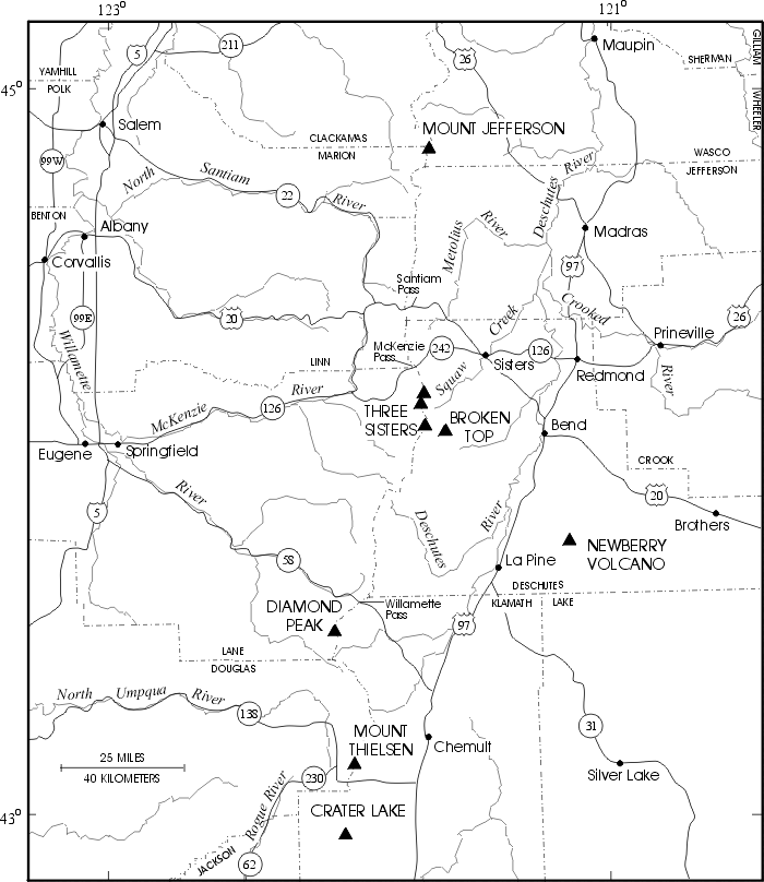
Figure 1. Regional setting of Three Sisters region in Central Oregon showing major rivers, highways, cities, and counties.
All of the types of hazardous events depicted in the accompanying illustration of a composite volcano (Figure 2) have occurred at South and Middle Sister in the past and could occur in the future. Most are driven by the eruption of molten rock, or magma, but some, like debris avalanches and some lahars, can occur even without eruptive activity.
As magma nears the surface, gases dissolved in the magma are released. Rapid release can fragment the magma and propel it upward from the vent in a rush of expanding hot gas. The resulting solidified rock fragments, called tephra, range in size from large bombs (fist-sized up to 1 meter or more in diameter) to fine dust. Large tephra particles will fall back to the ground within a few kilometers (miles) of the vent, but frothy pumice particles and ash (ash is tephra that is sand-sized and finer) can rise more than ten kilometers (30,000 feet) upward in an eruption cloud. As the cloud drifts downwind, tephra falls out and blankets areas for tens to hundreds of kilometers (miles) away. Unless tephra blankets reach thicknesses great enough to collapse roofs, tephra falls offer little direct threat to life or structures, but tephra clouds can create tens of minutes to hours of darkness as they pass over a downwind area, even on sunny days, and reduce visibility on highways. Ash suspended in air can irritate eyes and respiratory systems, and prolonged inhalation of certain kinds of tephra can cause chronic lung disease. Deposits of tephra can topple or short-circuit electric transformers and power lines, especially if the tephra is wet, which makes it adhere to surfaces. Tephra ingested by vehicle engines can clog filters and increase wear. Tephra clouds commonly generate lightning that can interfere with electrical and communication systems and start fires. Finally, and perhaps most importantly, even small, dilute tephra clouds pose great hazards to aircraft that fly into them.
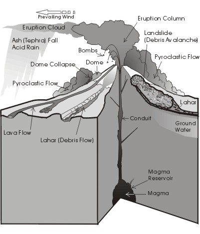
Figure 2. Hazardous events at
composite volcanoes. Illustration modified from USGS Fact Sheet
002-97.
Lessons learned during the 1980 eruption of Mount St. Helens in downwind Washington communities such as Yakima, Ritzville, and Spokane are now used throughout the Pacific Northwest and elsewhere to prepare governments, businesses, and citizens for future tephra falls. These three communities experienced significant disruptions in transportation, business activity, and community services as a result of fallout of from 0.5 to 8 centimeters (1/4 to 3 inches) of tephra. The greater the amount of tephra that fell, the longer a community took to recover. As perceived by residents, tephra falls of less than 0.5 centimeters (1/4 inch) were a major inconvenience, whereas falls of more than 1.5 centimeters (2/3 inch) constituted a disaster. Nonetheless, all three communities recovered to nearly normal activities within two weeks.
If all or part of a rising eruption column is denser than the surrounding atmosphere, a slug of tephra and hot gas can collapse downward to form a pyroclastic flow, a mobile, hot (hundreds of degrees) mixture of rock fragments, ash, and gas that surges down the flanks of a volcano at speeds of 50 to more than 150 kilometers per hour (30-90 miles per hour). Most pyroclastic flows are confined to valley floors, but accompanying clouds of hot ash and gas rise higher and can overwhelm even ridge tops. Owing to their great velocity and high temperature, pyroclastic flows are particularly dangerous hazards to life and property, but pyroclastic flows would probably not travel more than 10 kilometers (6 miles) except in extraordinary events.
Less explosive release of gas from ascending magma results in extrusion of lava (magma that reaches Earth’s surface) from vents. Depending on its viscosity and rate of discharge, lava will form a bulbous lava dome over the vent or a lava flow that extends several to more than 10 kilometers (6 miles) downslope. Observations of lava flows at similar volcanoes elsewhere suggest that lava flows in the Three Sisters region would move down valleys as tongues of liquid lava a few to tens of meters (10-100 feet) thick encased in a thick cover of hardened lava rubble. Such lava flows can destroy all structures in their paths and start forest fires, but they advance so slowly that they seldom endanger people. Lava domes that grow on steep slopes are typically unstable and collapse repeatedly as they grow higher and steeper. Such collapses are another mechanism by which pyroclastic flows can form.
The latest eruptions on South Sister, which occurred in two closely spaced episodes about 2,000 years ago (Figure 3), illustrate a relatively modest scale of eruptive activity. Initial explosive eruptions produced small pyroclastic flows and tephra fallout from several aligned vents low on the south flank. Tephra fallout deposits more than 2 meters (7 feet) thick, composed of pumice, rock fragments, and ash, blanketed areas within 2 kilometers (1 mile) downwind of vents; at 13 kilometers (8 miles) about 10 centimeters (4 inches) fell. Less than one centimeter (0.5 inch) of ash fell at least as far as 40 kilometers (25 miles) south of the vents (at Cultus Lake) and east of the vents (at Bend). Following tephra eruptions, lava emerged from two vent areas, forming a large lava flow, Rock Mesa, and several small lava domes. Decades to a few centuries later, a similar eruptive sequence occurred along a zone of vents that extended from just north of Sparks Lake to high on the southeast flank of South Sister, as well as along a shorter zone on the north flank near Carver Lake. Some of the lava flows and domes of that episode are shown in the accompanying photograph (Figure 4). Similar-style eruptions, but up to about ten times larger in terms of volume of ejecta, occurred during and just before the last ice age, about 30,000 to 15,000 year ago.
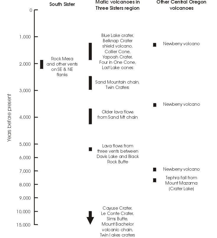
Figure 3. Volcanic activity in the Three Sisters region and other Central Oregon volcanoes during the past 15,000 years [1]. Bars indicate approximate age of events or age ranges of several events. Arrow indicates that ages of eruptions are poorly known and may predate 15,000 years ago by several thousand years.
The geologic record shows that even much larger eruptions with much wider impact have occurred in the Three Sisters volcanic center. At least four times in the past 700,000 years, explosive eruptions that were probably sited near the present location of Broken Top and Three Sisters produced pyroclastic flows that swept over a broad area from Sisters to south of Bend. A tephra fallout deposit as thick as 13 meters (42 feet) composed largely of fist-sized and smaller white pumice clasts from one of these eruptions is exposed in numerous pumice quarries. Distal tephra deposits from this event have even been found in northern California and in cores from the northeast Pacific Ocean. Such an event today would be catastrophic for Deschutes County, but, fortunately, events of this magnitude are infrequent. Furthermore, there is no evidence that the large volume of magma necessary to drive such an eruption is present in the Three Sisters region today, nor would such a volume likely be generated in the near future.
Pyroclastic flows on volcanoes like South and Middle Sister can melt snow and glacier ice and generate lahars. Lahars are watery flows of volcanic rocks and mud that surge downstream like rapidly flowing concrete. Lahars can devastate valley floors tens of kilometers (or miles) from volcanoes. Small lahars were generated by eruptions 2,000 years ago. Much larger lahars swept down valleys during earlier eruptions, but their deposits have been largely removed by erosion or buried by younger glacial and stream deposits. During the past century, at least five small lahars were generated by glacier-outburst floods or by failure of glacial-moraine dams that impounded small lakes on each of the Three Sisters and Broken Top. Serious effects of these events were largely restricted to undeveloped areas within 10 kilometers (6 miles) of sources.
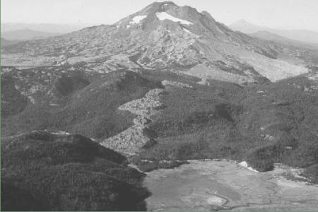
Figure 4. Aerial view of the south flank of South Sister composite volcano showing numerous blocky lava flows erupted about 2,000 years ago. Early eruptions formed Rock Mesa (just above center, far left), a broad flat flow emplaced on nearly level ground. Subsequent eruptions formed a line of lava domes and flows that extend from Sparks Lake meadow (lower right) to Green Lakes (just above center, far right). Several small lava domes were also formed on the northeast flank, out of view. Cratered cone in lower left is Talapus Butte, a basaltic scoria cone. Photo by William E. Scott, USGS
Lahars also affect downstream areas by filling stream channels with sediment and by providing a source of sediment for continued erosion and valley filling. Examples from many volcanoes, including Mount St. Helens, show that these effects can persist for years or decades. In such situations channels become unstable and shift rapidly. Channel capacity shrinks and susceptibility to flooding increases.
Mafic volcanoes typically erupt less explosively than do composite volcanoes, so their eruption impacts are less widespread. Most mafic eruptions in the Three Sisters region have produced limited tephra deposits and lava flows that traveled typically 5-15 kilometers (3-9 miles) and rarely 15-20 kilometers (9-12 miles) from vents. Tephra deposits from such eruptions locally have thicknesses of several meters (6-12 feet) within 2 kilometers (1.2 miles) of vents, but seldom exceed 10 centimeters (4 inches) at distances 10 kilometers (6 miles) away from vents, and are typically much less. Some eruptions built scoria cones (piles of volcanic rubble centered around vents) with aprons of lava flows, like Pilot Butte in Bend. Others constructed broad shield volcanoes like Belknap Crater (Figure 5) north of McKenzie Pass, which has lava flows that cover 100 square kilometers (40 square miles). At about 1,500 years old, Belknap Crater is one of the youngest mafic volcanoes in the Oregon Cascades. Some mafic eruptions constructed only a single small volcano, probably in a matter of days or weeks, while others involved eruptions along chains of several to tens of vents that may have continued for decades or centuries. The cluster of scoria cones and lava flows in the Sand Mountain area west of Santiam Pass was formed during three eruptive episodes between about 2,000 and 4,000 years ago. Mount Bachelor, a 1,000-meter-high (3,500 feet) mafic shield volcano, lies at the north end of a 25-kilometer-long (15 mile) chain of scoria cones and shield volcanoes that together cover 250 square kilometers (100 square miles). The entire chain formed over a period of several thousand years that ended about 12,000 years ago.
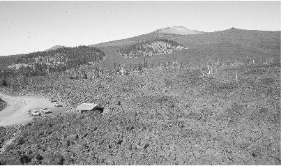
Figure 5. Belknap Crater (on skyline, right of center) and Little Belknap (right) mafic shield volcanoes lie just north of McKenzie Pass. Both are formed of lava flows and scoria deposits that were erupted about 1,500 years ago. Photo by William E. Scott, USGS
Lava flows that dam or divert streams and rivers generate additional hazards. Lakes formed behind lava dams can submerge large upstream areas depending on dam height and topography. For example, about 7,000 years ago a lava flow from Lava Butte dammed the reach of the Deschutes River just below Sunriver and flooded much of the broad basin from Sunriver to almost La Pine. Popular recreational lakes like Clear Lake in the upper McKenzie valley and Sparks, Elk, and Lava Lakes in the upper Deschutes valley are all dammed by lava flows. Lakes dammed by lava flows can also cause flooding downstream if conditions favor rapid erosion of lake outlets.
The most hazardous events at mafic volcanoes occur when rising magma interacts explosively with surface water or shallow ground water. Such explosions form craters and can generate pyroclastic flows that sweep outward several kilometers. North and South Twin Lakes, near Wickiup Reservoir, fill two of a series of explosion craters formed in this way. Future mafic eruptions in areas of abundant ground or surface water like the basins of Sparks Lake, Crane Prairie, and Wickiup Reservoir might result in this type of explosive activity.
The accompanying volcano-hazards zonation map shows areas most likely to be affected by future hazardous geologic events in the Three Sisters region. Individual events typically affect only part of a hazard zone. The location and size of an affected area will depend on the location of the erupting vent or landslide, the volume of material involved, the snow and ice conditions around and down slope from the vent, and the character of an eruption, especially its explosivity.
Hazardous areas around composite volcanoes are divided into proximal and distal hazard zones depending on distance from the volcano. Some zones are subdivided further on the basis of their relative degree of hazard. Zone boundaries are positioned on the basis of (1) the magnitude of past events at the volcano, as inferred from deposits; (2) mathematical models that use calibrations from other volcanoes to forecast the probable extent of future pyroclastic flows, debris avalanches, and lahars; and (3) our experience and judgment derived from observations and understanding of events at other similar volcanoes. A regional hazard zone for lava flows of mafic volcanoes is also shown. Hazard zones for tephra falls are shown as small-scale inset maps.
Although the hazard map shows sharp boundaries for hazard zones, the degree of hazard does not change abruptly at these boundaries. Rather, the hazard decreases gradually as distance from the volcano increases and decreases more rapidly as elevation above valley floors increases. Areas immediately beyond outer hazard zones should not be regarded as hazard-free, because the boundaries can only be located approximately, especially in areas of low relief. Too many uncertainties exist about the source, size, and mobility of future events to locate the boundaries of zero-hazard zones precisely.
The proximal hazard zone includes areas immediately surrounding the three composite volcanoes, Middle and South Sister and Broken Top, and the large mafic volcano, North Sister. This zone, which extends outward from summits for as little as 2 to as many as 10 kilometers (6 miles) depending on local topography, is subject to several types of rapidly moving, devastating flows including pyroclastic flows, debris avalanches, lahars, and dam-break floods [3]. Lava flows could also affect these zones, but they would move much more slowly.
On the basis of eruptive activity during the recent geologic past, Middle and South Sister are the most likely locations for explosive eruptions that could generate pyroclastic flows. As in the past, vents may open anywhere on these volcanoes, from the summit to lower flanks. Because such flows are driven by gravity, those that originate at higher altitudes will generally travel farther. Eruptions on these peaks would also melt sufficient snow and ice to generate lahars large enough to extend into the distal hazard zones.
The probability of future explosive eruptions at Middle and South Sister is difficult to estimate from the geologic record owing to its fragmentary nature. Since the last ice age ended, about 12,000 years ago, only two episodes of explosive eruptions occurred at South Sister, and these were so closely spaced in time about 2,000 years ago that we regard them as a single eruptive period that lasted several decades to a few centuries and encompassed numerous separate eruptive events. Erosion by ice-age glaciers makes detailed identification and dating of explosive activity during and prior to the last ice age difficult, but preliminary studies suggest that at least several eruptive periods occurred at South Sister between about 30,000 and 12,000 years ago although none of these periods are well dated [1]. This fragmentary record indicates that major periods of eruptive activity may be separated by several thousand to as much as 10,000 years of dormancy, which implies an annual probability of entering a new period of eruptive activity at South and Middle Sister of one in several thousand to 1 in 10,000. However, any signs of restlessness at these volcanoes will increase these probabilities dramatically. Annual probabilities would likewise rise greatly if a volcano were to enter an eruptive period.
South, Middle, and North Sister as well as Broken Top are high, steep-sided peaks that could also produce debris avalanches. Avalanches of modest volume (less than about 10 million cubic meters) are the most probable and would affect areas primarily within the proximal hazard zone. Nevertheless, even modest-sized avalanches that contain sufficient water could transform into lahars that travel well into distal hazard zones. Very large avalanches, those involving hundreds of millions of cubic meters of rock debris would likely be preceded by pronounced volcano deformation driven by intrusion of magma. Such activity would be detectable by seismometers and volcano surveys, and thus would elicit advance warning.
Failure of glacial moraine dams that impound high-altitude lakes around the Three Sisters and Broken Top could release floods of water and debris whose major impact would be restricted to the proximal hazard zone but which could inundate parts of distal hazard zones adjacent to streams. Carver Lake, which lies in the headwaters of the South Fork of Squaw Creek, and the lake on the east side of Broken Top that drains to Sparks Lake by way of Crater Creek and Soda Creek, are judged the most likely lakes to generate future floods or debris flows large enough to affect areas beyond the proximal hazard zone [4]. Others of less hazard include several small lakes in the headwaters of Squaw Creek and the basin (currently with no lake) below Collier Glacier at the head of White Branch.
Explosive eruptions or large debris avalanches on the volcanoes in the proximal hazard zone can generate lahars of sufficient volume to travel tens of kilometers (or miles) from source areas. The hazard-zonation map shows that distal hazards from such events are concentrated in the valleys of the McKenzie River and its tributaries (White Branch, Separation Creek, and Horse Creek), the upper Deschutes River, and two Deschutes tributaries (Tumalo and Squaw Creeks). Debris avalanches and lahars will tend to funnel into these valleys as they leave the slopes of the large volcanoes within the proximal hazard zone.
Eruptions 2,000 years ago did not melt enough snow and ice to generate lahars that traveled much beyond the proximal hazard zone. Some previous eruptions probably generated lahars that inundated distal zones, but geologic evidence of such events is scant and provides little guidance to forecasting the extent of lahars that may be produced by future eruptions. Likewise, we have no record of large lahars generated by debris avalanches from which to assess potential hazards. We therefore use a mathematical technique that uses data from other volcanoes to estimate the extent of distal inundation by future lahars of various volumes [5].
For each of the major valleys draining the Three Sisters and Broken Top volcanoes, we computed three nested distal hazard zones that depict anticipated inundation by hypothetical lahars of three volumes. The largest of these hypothetical lahar volumes yields the largest distal hazard zone in each valley; it results from our estimate of the maximum quantity of debris that might descend suddenly from South or Middle Sister. However, such extreme lahars would require wholesale failure of a large part of an upper volcano flank and are unlikely to occur without precursory volcanic activity. The smallest distal hazard zone in each valley depicts anticipated inundation patterns from lahars 25 times smaller, which might occur without volcanic precursors. A hazard zone for only this smallest hypothetical event is shown in the valley of Tumalo Creek on the east side of Broken Top, because larger events are very improbable given the small volume of material available in the drainage area upstream.
Because large lahars are less likely to occur than are small lahars, the nested distal hazard zones show that the likelihood of lahar inundation decreases as distances from volcanoes and elevations above valley floors increase. On the basis of no prior events in the past 10,000 years, we estimate that a lahar voluminous enough to inundate the largest of the distal hazard zones in any valley has an annual probability less than 1 in 10,000. A lahar voluminous enough to inundate the smallest of the distal hazard zones in any valley has a greater annual probability, perhaps between 1 in 1000 to 1 in 10,000. Still smaller lahars that result from phenomena such as moraine-dam failures are much more likely to occur (annual probability greater than 1 in 100 in potentially affected valleys), but are apt to inundate only parts of the smallest distal hazard zones immediately adjacent to streams. In such instances, some debris may travel farther downstream but stay mostly confined within stream banks.
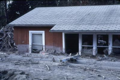
Figure 6. This house in a distal hazard zone of Mount St. Helens was partly buried by lahars from the 1980 eruption. Note the high mud line on the house and large amounts of woody debris carried by the lahars. Photo by Lyn Topinka, USGS.
White Branch and Separation Creek drain the west slopes of North, Middle, and South Sister. Separation Creek joins the valley of Horse Creek, and the valleys of both Horse Creek and White Branch enter the McKenzie River valley near McKenzie Bridge. Smaller-volume lahars will largely come to rest here as material is deposited in this broad and relatively gently sloping reach of the valley. Parts of these lahars could continue downstream, but be largely restricted to channels and flood plains. The potential exists for deposits in the area around Belknap Springs or McKenzie Bridge to temporarily impound water in the reach of the McKenzie immediately upstream. Breaching of these temporary debris dams could send floods and lahars racing further downstream. Larger-volume lahars will travel much farther westward.
Flushing of sediment from lahar-impacted areas in the years and decades following eruptions could fill the McKenzie River channel, decreasing its capacity to carry flood water and causing the channel to shift across the valley floor. Depending on the volume of lahar deposits and degree of disturbance to the watershed, such effects could spawn ongoing sediment problems in the lower McKenzie valley and along the Willamette River below the McKenzie confluence, far beyond the initial path of lahars.
The upper Deschutes River valley, which heads on the south flank of South Sister and the south and west slopes of Broken Top, consists of a series of broad lava-dammed basins such as those containing Sparks, Elk, and Lava Lakes and Crane Prairie Reservoir. These basins will effectively retard the downstream advance of lahars by causing deposition. However, persistent sediment problems could follow lahar emplacement as sediment is flushed through these shallow basins, into Wickiup Reservoir, and farther downstream. Large developed areas of Sunriver and Bend lie close to the flood plain of the Deschutes River and could be affected by channel aggradation and migration resulting from increased sediment loads.
Tumalo Creek drains the area east of Broken Top and is unlikely to experience large lahars owing to lack of much volcano mass in its headwaters. Nevertheless, small lahars might descend Tumalo Creek if rapid sedimentation in Crater Creek accompanied a large landslide or failure of the moraine dam on the east side of Broken Top and diverted debris over a low divide into Tumalo Creek. Some debris might also enter Tumalo Creek by way of Crater Creek Ditch to the south of Broken Top.
Squaw Creek and its tributaries drain the east flanks of North, Middle, and South Sister and the north flank of Broken Top. The headwater streams join above a narrow valley that opens into a broad, gently sloping debris fan occupied, in part, by the city of Sisters. Below Sisters, Squaw Creek enters a narrow, deepening canyon that joins the canyon of the Deschutes River just upstream from Lake Billy Chinook.
The broad fan of Squaw Creek around Sisters is of particular concern with regard to potential lahar inundation because Squaw Creek drains a large sector of the major volcanoes and the distance to Sisters is relatively short (about 30 kilometers or 20 miles). Typical flow velocities for lahars through terrain like that along Squaw Creek yield travel times to Sisters of as little as 30 minutes to one hour, depending on lahar size and point of origin.
The regional lava-flow hazard zone outlines the area of the Three Sisters region subject to lava flows from eruptions of mafic volcanoes. The zone is defined by the distribution of mafic volcanoes that formed during roughly the past one million years. Hazards from thick tephra fall, ballistic projectiles, and pyroclastic flows would be restricted to within a few kilometers of vents, but lava flows could travel much farther. As past lava flows from mafic volcanoes in the region traveled typically less than 10 to 15 kilometers (6 to 9 miles) and rarely 15-20 kilometers (9-12 miles) from vents, we locate the hazard zone boundary about 10 kilometers downslope from the margin of the potential vent area, but caution that exceptional lava flows could extend farther. The hazard zone covers a broad area in central Oregon, including Bend, Sisters, and La Pine.
The lava-flow hazard zone includes areas on the lower flanks of Newberry volcano that are described in a report similar to this one (U.S. Geological Survey Open-File Report 97-513, see References and Suggested Additional Reading).
The annual probability of an eruption of a mafic volcano within the Three Sisters region can be estimated from the frequency of past activity as shown in the middle column of Figure 3. During the past 6,000 years, four episodes of activity, each lasting up to several centuries long and consisting of eruption of scoria and lava flows from several vents, have affected the region. Such a frequency suggests that the average annual probability of future mafic eruptions is roughly 1 in 1,500 [6]. Because most recent activity has been concentrated in the area between the North Sister and Santiam Pass, future activity is probably more likely there than in other parts of the lava-flow hazard zone to the south and east, which includes most of the settled areas in the region. Furthermore, because only a relatively small part of the entire lava-flow hazard zone is affected during one eruptive episode, the annual probability of any given point in the hazard zone being affected is considerably less than the average annual probability of 1 in 1,500. We estimate the range of annual probabilities falls between 1 in 10,000, for some areas near the Cascade Crest around Three Sisters and on the upper flanks of Newberry volcano, to 1 in 1,000,000 elsewhere.
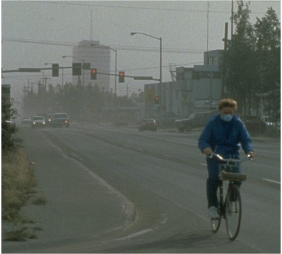
Figure 7. Even a minor tephra fall can be disruptive in populated areas. Visibility was reduced by this tephra fall of less than 3 millimeters (1/8 inch) in Anchorage, Alaska, produced by an eruption of Mount Spurr, which lies 130 kilometers (80 miles) away. Wind and vehicles resuspended the tephra for days following the initial fall. The simple dust mask worn by the bicycle rider is an effective way to minimize inhaling ash particles. Photo by Richard Emanuel, USGS.
Eruptions of composite and mafic volcanoes in the Three Sisters region as well as more distant volcanoes in the Cascade Range are all sources of potential tephra fall in local communities. In fact, since the last ice age, the thickest tephra fall in the Bend area, probably about 30 centimeters (one foot), originated from the huge eruption of ancient Mount Mazama that created Crater Lake about 7,600 years ago.
The inset maps on the hazard-zonation map show the annual probability of tephra fall affecting the central Oregon region from all major Cascade volcanic centers. The maps are based on the combined likelihood of tephra-producing eruptions occurring at Cascade centers, the relationship between thickness of a tephra-fall deposit and distance from its source vent, and regional wind patterns [7]. Probability zones extend farther east of the range because winds blow from westerly directions most of the time. One map shows annual probabilities for a fall of one centimeter (about 0.4 inch) or more and the other for a fall of 10 centimeters (about 4 inches) or more. The map patterns illustrate clearly the dominating influence of Mount St. Helens as a tephra producer. Because small eruptions are more numerous than large eruptions, the probability of a thick tephra fall at a given locality is lower than that of a thin tephra fall. The most densely populated areas of Central Oregon have an annual probability of a tephra fall of 10 centimeters or more of no greater than 1 in 10,000 and an annual probability of a fall of 1 centimeter or more of about 1 in 1,000 to 1 in 5,000. The annual probability of a fall of a few millimeters (fraction of an inch) of tephra is probably greater than 1 in 1,000.
Scientists recognize several signs of impending volcanic eruptions. The upward movement of magma into a volcano prior to an eruption causes changes that can usually be detected by geophysical instruments and visual observation. Swarms of small earthquakes are generated as rocks break to make room for rising magma or as heating of fluids causes underground pressures to increase. Heat from the magma can increase the temperature of ground water and boost temperatures and steaming from fumaroles; it can also generate small steam explosions. The composition of gases emitted by fumaroles can change as magma nears the surface. Injection of magma into the volcano can cause swelling or other types of surface deformation.
A regional seismic network, the Pacific Northwest Seismograph Network, operated jointly by the Geophysics Program at the University of Washington and U.S. Geological Survey has located few earthquakes in the Three Sisters region during the past two decades. The onset of earthquake activity would quickly gain scientists’ attention and prompt deployment of additional seismometers to better locate earthquakes. At monitored volcanoes elsewhere in the world similar to those in the Three Sisters region, a notable increase in seismicity has occurred days to months before eruptions. Earthquakes associated with volcanic unrest are typically small (rarely exceeding magnitude 4) and generally pose little direct hazard to structures in surrounding communities.
Scientists have conducted other studies aimed at developing baseline data to help detect precursory activity at South Sister. A network of precisely surveyed points has been remeasured several times. An increase in seismicity would prompt the resurvey of this network or creation of new networks to look for slight ground movements that might indicate upward movement of new magma. Concurrently, ground-based and airborne techniques would be employed to search for signs of volcanic gas release, another sign of magma movement.
Periods of unrest at volcanoes are usually times of great uncertainty. Although outstanding advances have been made in volcano monitoring and eruption forecasting over the past few decades, scientists are often able to make only very general statements about the probability, type, and scale of an impending eruption. Precursory activity can go through accelerating and decelerating phases, and sometimes die out without leading to eruption. Government officials and the public must realize the limitations in forecasting eruptions and be prepared for such uncertainty.
Communities, businesses, and citizens need to plan ahead to mitigate the effects of future eruptions, debris avalanches, and lahars. Long-term mitigation includes using information about volcano hazards when making decisions about land use and siting of critical facilities. For example, development could avoid areas judged to have an unacceptably high risk or be planned to reduce the level of risk.
When volcanoes erupt or threaten to erupt, appropriate emergency responses are needed. Such responses will be most effective if citizens and public officials have an understanding of volcano hazards and have planned the actions needed to protect communities. Because an eruption can occur within days to months of the first precursory activity and because some hazardous events can occur without warning, suitable emergency plans should be made beforehand. Public officials need to consider issues such as public education, communications, and evacuations. Emergency plans already developed for floods may apply, with modifications, to hazards from lahars.
Businesses and individuals should also make plans to respond to volcano emergencies. Planning is prudent because once an emergency begins, public resources can often be overwhelmed, and citizens may need to provide for themselves and make informed decisions. The Red Cross recommends numerous items that should be kept in homes, cars, and businesses for many types of emergencies that are much more probable than a volcanic eruption. A map showing the shortest route to high ground will also be helpful.
The most important additional item is knowledge about volcano hazards and, especially, a plan of action based on the relative safety of areas around home, school, and work. Lahars pose the biggest sudden threat to people living in valleys that drain the Three Sisters. The best strategy for avoiding a lahar is to move to the highest possible ground. A safe height above river channels depends on many factors including size of the lahar, distance from the volcano, and shape of the valley. For areas beyond the proximal hazard zone, all but the largest lahars will probably rise less than 30 meters (100 feet) above river level.
Blong, R.J., 1984, Volcanic hazards—a sourcebook on the effects of eruptions: Orlando, Florida, Academic Press, 424 p.
Sherrod, D.R., Mastin, L.G., Scott, W.E., and Schilling, S.P., 1997, Volcano hazards at Newberry volcano, Oregon: U.S. Geological Survey Open-File Report 97-513, 14 p.
Tilling, R.I., editor, 1989, Volcanic hazards: Washington, D.C., American Geophysical Union, 123 p.
Walder, J.S., Gardner, C.A., Conrey, R.M., Fisher, B.J., and Schilling, S.P., 1999, Volcano Hazards in the Mount Jefferson Region, Oregon: U.S. Geological Survey Open-File Report 99-24, 14 p.
Warrick, R.A., and others, 1981, Four communities under ash: after Mount St. Helens: Boulder, Colorado, University of Colorado Institute of Behavioral Science Monograph No. 34, 143 p.
Wood, C.A., and Kienle, Jürgen, editors, 1990, Volcanoes of North America: New York, Cambridge University Press, 354 p.
[1] The geologic data upon which this report is based comes from many published reports and maps about the Three Sisters region. Sources include: Hill, B.E., and Taylor, E.M., 1990, Oregon central High Cascade pyroclastic units in the vicinity of Bend, Oregon: Oregon Geology, v. 52, no. 6; Mimura, Koji, 1992, Reconnaissance geologic map of the west half of the Bend and the east half of the Shevlin Park 7 1/2' quadrangles, Deschutes County, Oregon: U.S. Geological Survey Miscellaneous Field Investigations Map MF-2189; Peterson, N.V., Groh, E.A., Taylor, E.M., and Stensland, D.E., 1976, Geology and mineral resources of Deschutes County, Oregon: Oregon Department of Geology and Mineral Industries Bulletin 89; Sarna-Wojcicki, A.M., Morrison, S.D., Meyer, C.E., and Hillhouse, J.W., 1987, Correlation of upper Cenozoic tephra layers between sediments of the western United States and eastern Pacific Ocean and comparison with biostratigraphic and magnetostratigraphic age data: Geological Society of America Bulletin, v.98, no. 2; Scott, W.E., 1987, Holocene rhyodacite eruptions on the flanks of South Sister volcano, Oregon: Geological Society of America Special paper 212; Scott, W.E., and Gardner, C.A., 1992, Geologic map of the Mount Bachelor volcanic chain and surrounding area, Cascade Range, Oregon: U.S. Geological Survey Miscellaneous Investigations Map I-1967; Sherrod, D.R., Taylor, E.M., Ferns, M.L., Scott, W.E., Conrey, R.M., and Smith, G.A., in press, Geologic map of the Bend 30- by 60-minute quadrangle, central Oregon: U.S. Geological Survey Miscellaneous Investigations Map I-2683; Taylor, E.M., 1965, Recent volcanism between Three Fingered Jack and North Sister, Oregon Cascade Range: Part I: History of volcanic activity: Ore Bin, v. 27, no. 7; Taylor, E.M., 1978, Field geology of S.W. Broken Top quadrangle, Oregon: State of Oregon Department of Geology and Mineral Industries, Special Paper 2; Taylor, E.M., 1987, Field geology of the northwest quarter of the Broken Top 15' quadrangle, Deschutes County, Oregon: State of Oregon Department of Geology and Mineral Industries, Special Paper 21; Taylor, E.M., MacLeod, N.S., Sherrod, D.R., and Walker, G.W., 1987, Geologic map of the Three Sisters Wilderness, Deschutes, Lane, and Linn counties, Oregon: U.S. Geological Survey Miscellaneous Field Studies Map MF-1952.
[2] Mafic refers to the type of lava erupted by these short-lived volcanoes. Most are composed of basalt or basaltic andesite—a few are andesite. This contrasts with composite volcanoes that erupt mafic lava as well as more silica-rich lava such as dacite or rhyolite. Eruption of silica-rich lava is typically more explosive than that of mafic lava.
[3] The proximal hazard zone was created by projecting so-called energy cones described by H/L = 0.2 from the summits of four high peaks (South, Middle, and North Sister and Broken Top) on a digital topographic base map of the Three Sisters area (cf. e.g., Malin, M.C., and Sheridan, M.F., 1982, Computer-assisted mapping of pyroclastic surges, Science, 217, 637-640; Hayashi, J.N., and Self, S., 1992, A comparison of pyroclastic flow and debris avalanche mobility, Journal of Geophysical Research, 97(B), 9063-9071; Iverson, R.M., Schilling, S.P. and Vallance, J.W., 1998, Objective delineation of lahar-inundation zones: Geological Society of America Bulletin, 110, 972-984). Here H is the vertical distance of descent from the summit, and L is the horizontal distance of travel from the summit. Pyroclastic flows typically exhibit energy-cone slopes no lower than H/L = 0.2. Debris avalanches of large volume (more than 100 million cubic meters) can exhibit lower energy-cone slopes than do pyroclastic flows (travel farther for a given drop), and most such far-traveled avalanches at Three Sisters would funnel from the proximal hazard zone into valleys encompassed within distal hazard zones.
[4] Detailed assessments of floods and lahars associated with emptying of moraine-dammed lakes in the Three Sisters region have been described elsewhere (Laenen, A., Scott, K.M., Costa, J.E., and Orzol, L.L., 1987, Hydrologic hazards along Squaw Creek from a hypothetical failure of the glacial moraine impounding Carver lake near Sisters, Oregon, U.S. Geological survey Open-file Report 87-41; O’Connor, J.E., Hardison III, J.H., and Costa, J.E., in press, Debris flows from failures of Neoglacial moraine dams in the Three Sisters and Mt. Jefferson Wilderness Areas, Oregon, U.S. Geological Survey Professional Paper 1608). These assessments indicate that moraine-dammed lakes in the Three Sisters region contain less than 1 million cubic meters of water each. On the basis of this water volume, lake geometry, and the past behavior of dam-breach floods in the Three Sisters region and elsewhere (i.e., Walder, J.S., and O’Connor, J.E., 1997, Methods for predicting peak discharge of floods caused by failure of natural and constructed earthen dams, Water Resources Research, 33, 2337-2348), we estimate that water discharges resulting from future failures of moraine dams in the Three Sisters region will probably not exceed 300 cubic meters per second (10,000 cubic feet per second). Flood magnitude might increase where substantial volumes of sediment are entrained to form lahars, but the resulting lahar volume is unlikely to exceed several million cubic meters. The resulting areas of downstream innundation will probably be smaller than those shown for the smallest (inner) distal hazard zone shown on the map.
[5] Distal lahar hazard zones were constructed by assuming hypothetical lahar volumes of 20 million, 100 million, and 500 million cubic meters. Using mathematical and digital cartographic techniques described by Iverson, R.M., Schilling, S.P., and Vallance, J.W., 1998, Objective delineation of lahar-inundation zones: Geological Society of America Bulletin, v. 110, p. 972-984, these three volumes were used to compute the probable extent of inundation downstream from the proximal hazard zone. The largest assumed volume (500 million cubic meters) represents the largest event that we believe could occur at the Three Sisters, and it produces the largest distal hazard zones. The smaller assumed volumes produce smaller nested hazard zones.
[6] The average frequency is one eruptive episode per 1,500 years (6,000/4 = 1,500). The average annual probability of the onset of a future episode is therefore 1 in 1,500.
[7] Tephra-hazard maps were generated by computer program developed by R.P. Hoblitt (U.S. Geological Survey, Cascades Volcano Observatory, 1996).
To contact the author, email William Scott (wescott@usgs.gov).