Core Data
| Explanation: core logs and sedimentary facies |
 |
gravel (> 60% gravel) |
 |
 |
gravelly sand (< 3% mud and 25-60% gravel) |
 |
sand (< 3% mud and < 25% gravel) |
 |
muddy sand (3-50% mud) |
 |
mud (> 50% mud) |
 |
Pleistocene facies |
 |
Miocene (limestone and blue-green clay) |
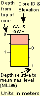
Seven generalized sedimentary-facies types were defined for a unified comparison of core data from the entire study area. All seven color-coded facies for the entire study are shown in the Explanation below. However, not all facies necessarily are present on each transect. Core photographs present individual cores cut into 1-m sections from top (upper left) to bottom (lower right). Discrepancies in core length between the photographs and the diagrams are due to compaction during the coring process. Offshore cores (left) are aligned at core tops. Core locations were chosen to sample thicker Holocene sections and to aid in identifying pre-Holocene stratigraphy. Core elevations were determined from water depth and tide tables. The datum for the barrier-transect cores is the mean lowest low water (MLLW).
Offshore vibracore retrieval was consistently less than 1.5 m in length. Even though none of the underlying platform deposits were collected, the contorted nature of the barrel bottoms suggests the entire sediment thickness was penetrated. Offshore cores consistently contain a thin surface layer of sand-size material overlying pre-Holocene deposits. Sands contain a large amount of blackened grains believed to have been derived from the underlying Miocene sequences. The thin sediment cover and erosional origin of sediments illustrates the lack of significant sediment influx to this part of the study area.
Cores from the barrier reveal somewhat coarser sands associated with Longboat Key, grading to muddy sands below Sarasota Bay. Abundant channel deposits reflect the dynamic history of coastal change, including inlet closure, over the past few thousand years. The island cross section (Yale, 1997) is located in widest section of central Longboat Key, once occupied by an open tidal inlet. On cross sections where cores do not penetrate to bedrock, the control is based on probe-rod data.