
![]()
Why Measure the Magnetic Field of the Earth?
Geologic structures (like ore bodies or faults) often produce small magnetic fields that distort the main magnetic field of the earth. These "anomalies" can be detected by measuring the magnetic field near the surface of the ground. By analyzing these measurements, geophysicists can learn about geologic structures, even though the structures may be concealed entirely below the earth's surface.
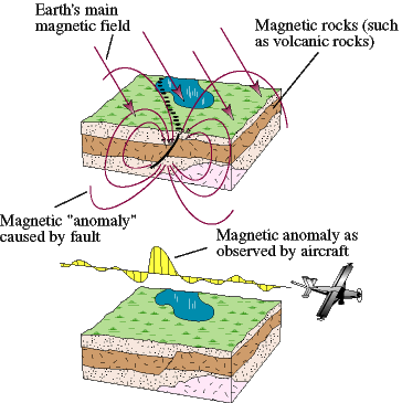
Magnetic measurements are usually made from low-flying airplanes flying along closely spaced, parallel flight lines. Additional flight lines are flown in the perpendicular direction to assist in data processing. These huge volumes of measurements then are processed into a digital aeromagnetic map. Assisted by computer programs, the geophysicist builds a geologic interpretation from the digital aeromagnetic data, incorporating geologic mapping and other geophysical information (gravity, seismic-reflection) where available. Interpretations often involve both map-based information (e.g., a fault map) and three-dimensional information (e.g., a geologic cross section).

Additional reading
Blakely, R.J., 1995, Potential Theory in Gravity and Magnetic Applications: Cambridge University Press, 441 p. (for those interested in the theoretical and mathematical aspects of magnetic interpretation).
Dobrin, M.B., and Savit, C.H., 1988, Introduction to Geophysical Prospecting (fourth edition): McGraw-Hill, Inc., 867 p. (for those interested in survey methods and a less technical discussion of the theory).
URL:
https://pubs.usgs.gov/of/1999/of99-514
Maintained by: Michael F. Diggles
Last modified: October 27, 2005