Open-File Report 99–527
with Logistics Report, by High-Sense Geophysics Limited
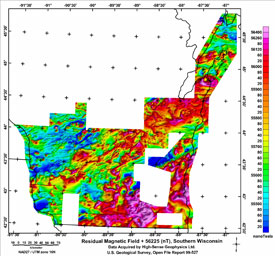
SummaryThis report contains digital data, image files, and text files describing the data formats and survey procedures for aeromagnetic data collected in the southern one-third of Wisconsin during 1998-1999. Over the past 12 years the U.S. Geological Survey has conducted a series of aeromagnetic surveys in Wisconsin aimed at completing the coverage of high-quality, moderate-resolution aeromagnetic surveying in the State. The data from these surveys have proven to be an effective tool for delineating structures in the Precambrian basement in Wisconsin and have been useful in the study of the mineral resources in the region. Precambrian basement rocks rarely crop out in this region because of glacial deposits and Paleozoic sedimentary cover rocks. Surveys by the U.S. Geological Survey (USGS) in 1988 (Hittleman and others, 1992), 1996 (Snyder, 1998), and 1997 (Daniels and others, 1998) have closed gaps in the aeromagnetic coverage of the Midcontinent rift area, adjacent to Minnesota. The most recent survey flown in 1998-99 is the focus of this report. It extends aeromagnetic coverage southwards to the bottom of the State. This report releases the digital data for that survey. Both digital flight-line and gridded data are included as well as images of the gridded magnetic data presented as one contiguous map. Facts about this survey and parameters for the digital files are given. DataAll the available digital data in line and gridded data formats are contained within the following subdirectories of the data folder.
|
Posted online October 28, 2009
Part or all of this report is presented in Portable Document Format (PDF); the latest version of Adobe Reader or similar software is required to view it. Download the latest version of Adobe Reader, free of charge. |
Bracken, R.E., and Nicholson, S.W., 1999, Aeromagnetic surveying in Wisconsin 1998-99 -- Digital data files: U.S. Geological Survey Open-File Report 99-527, available online only.

![]() U.S. Department of the Interior |
U.S. Geological Survey
U.S. Department of the Interior |
U.S. Geological Survey
URL: http://
pubsdata.usgs.gov
/pubs/of/1999/of99-527/index.html
Page Contact Information: USGS Publications Team
Page Last Modified: Wednesday, 07-Dec-2016 17:50:08 EST
