Eastern Strait of Juan de Fuca region
The following abstract has been submitted for the 12/98 Annual Meeting of the American Geophysical Union
Neotectonics of the eastern Strait of Juan de Fuca region, northwestern Washington and southwestern British Columbia
S.Y. Johnson and S.V. Dadisman (Both at: USGS, Denver, CO 80225; sjohnson@usgs.gov), D. C. Mosher (Geological Survey of Canada, Sidney, BC, Canada V8L 4B2), R.J. Blakely, J. R. Childs, and R.E. Wells (USGS, Menlo Park, CA 94025), and S.B. Rhea (USGS, Denver, CO 80225)
Major population centers in western Washington and southwestern British Columbia overlie a regional crustal boundary that juxtaposes the Eocene basement of the Coast Range province and pre-Tertiary basement rocks of the Cascade Range, San Juan Islands, and southern Vancouver Island. Our investigations focus on a critical area in the eastern Strait of Juan de Fuca (ESJF) where the strike of this boundary changes from its northerly trend in western Washington to a westerly trend on southern Vancouver Island. In the ESJF, the boundary is characterized by a broad zone of deformation that includes several significant structures previously recognized mainly by geophysical anomalies. These structures include the west-trending Devils Mountain fault and northern Whidbey Island fault, the northwest trending southern Whidbey Island fault, and at least three north-northwest trending faults inferred to cut the northeastern Olympic Peninsula. Our efforts concentrate on documentation of the locations, lengths, geometries, and histories of active faults and folds in this broad structural zone, and on compilation of a database on active deformation that can be used for seismic hazard assessment. Our primary database includes about 2,700 km of U.S. Geological Survey and Geological Survey of Canada marine, high-resolution, seismic-reflection profiles, about 400 km of industry seismic reflection profiles (collected in the late 1960's to early 1980's), a new high-resolution aeromagnetic survey, and onland geologic investigations of places where offshore fault trends intersect coastlines. Preliminary interpretations of seismic reflection data suggest that (1) the westerly trace of the Devils Mountain fault extends more than 20 km into the ESJF and has experienced Quaternary south-directed thrusting; (2) the northern Whidbey Island fault consists of two splays bounding a basement block that appears to have been uplifted in the Quaternary; (3) Quaternary deformation has occurred on three discontinuous splays of the southern Whidbey Island fault; and (4) there is evidence for Quaternary deformation along at least 3 aeromagnetic anomalies that extend into the ESJF from the northeastern Olympic Peninsula. Basement relief along these structures is variable but generally low, suggesting relatively low slip rates, mainly lateral offsets, and (or) deep Quaternary erosion. Coastal bluff exposures of Quaternary deposits along fault trends are in several places variably faulted, sheared, warped, folded, destratified, and (or) cut by diapirs, consistent with the evidence for Quaternary deformation interpreted from seismic reflection data.
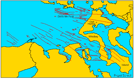
Preliminary map of faults (active and inactive) in the eastern Strait of Juan de Fuca region based on integrated analysis of USGS high-resolution seismic-reflection data and conventional industry seismic-reflection data.