ASSESSMENT OF LANDSLIDE HAZARDS
IN KALUANUI AND MAAKUA GULCHES, OAHU, HAWAII,
FOLLOWING THE 9 MAY 1999 SACRED FALLS LANDSLIDE
By Randall W. Jibson and Rex L. Baum
|
U.S. Department of the Interior |
 |
This report is preliminary and has not been reviewed for conformity with U.S. Geological Survey editorial standards or with the North American Stratigraphic Code. Any use of trade, product, or firm names is for descriptive purposes and does not imply endorsement by the U.S. Government.
Background
About 2:30 p.m. on Sunday, 9 May 1999, a landslide killed seven hikers and injured many more at Sacred Falls State Park, near Hauula on the north shore of Oahu, Hawaii.
|
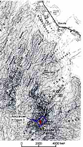
Figure 1. Topographic map showing Kaluanui gulch, Maakua gulch, and Sacred Falls (from USGS Hauula 1:24,000 quadrangle, contour interval 40 feet, north up). Area of Figure 3 shown. |
One of the injured hikers later died of injuries received in the landslide. Governor Ben Cayetano of Hawaii ordered that the park be closed due to concern about continuing landslide hazard near the falls. Subsequently, Bill Meyer, District Chief for the U.S. Geological Survey (USGS) Water Resources Division in Honolulu contacted Tim Johns, Chair of the Board of Land and Natural Resources of the Hawaii Department of Land and Natural Resources (DLNR) and offered assistance in assessing slope stability in the park. Mr. Johns accepted the offer, and two landslide specialists from the USGS Geologic Hazards Team in Golden Colorado were sent to the site. On Friday, 14 May 1999, we visited the Sacred Falls landslide site with Glenn Bauer, Ed Sakoda, and Gary Moniz of DLNR. The ground investigation involved inspecting the impact area, estimating the volume of the deposit, and gathering data to help reconstruct the event. On Monday, 17 May 1999, we conducted an aerial reconnaissance of Kaluanui Gulch (Sacred Falls State Park) and Maakua Gulch in a commercial helicopter provided by DLNR. We inspected the source and path of movement of the Sacred Falls landslide of 9 May and reconnoitered the full length of both valleys to get an overview of ongoing landslide hazards there. This report gives our observations and conclusions about the Sacred Falls landslide, broadly assesses the ongoing hazard in the Kaluanui and Maakua Gulches, and suggests methods for more detailed assessment of landslide hazards here and along other trails in state parks on Oahu. Observations and conclusions in this report are based on a very brief investigation and thus are preliminary in nature.
Sacred Falls Landslide of 9 May 1999
The Sacred Fall landslide is properly classified as a rock fall. The source of the Sacred Falls rock fall of 9 May 1999 is at an elevation of about 800 feet above sea level on the southeast canyon wall directly above the plunge pool of Sacred Falls.
|
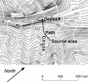
Figure 2. Topographic map showing approximate source area and path of 9 May rock fall (from Hawaii Department of Land and Natural Resources, contour interval 25 feet). Location shown in Figure 1. |
The source is easily visible because it is the only place on that part of the slope where there is no vegetation and fresh rock is exposed.
|
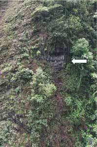
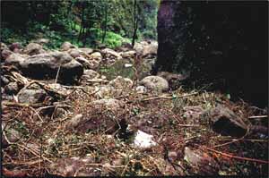
Figure 3. Source area (indicated by arrow) of Sacred Falls rock fall. |
The source area consists of a scar of freshly exposed rock about 15-20 feet wide by 10 feet high on a nearly vertical slope. The thickness of the slab of rock that failed appears to have been about 3-6 feet. The source is on a part of the valley wall that forms a promontory. Above the scar is a 3-foot overhang of intact rock that was created when the landslide material fell from beneath it. Below the scar is a track of uprooted or otherwise disturbed vegetation and impact marks left by the falling landslide material.
The landslide material cascaded down a 70º-80º slope and entered a dry waterfall chute that points directly
at the downstream end of the plunge pool at the base of Sacred Falls. The lip of this waterfall chute is at an
elevation of about 470 feet; below this point the chute forms a slight overhang with its surface being 2°-4°
out of vertical. Below the lip of the waterfall chute, the landslide debris would have lost contact with the ground
surface and been in free fall over the last part of its descent to the impact area at the edge of the pool at the
base of Sacred Falls, which lies at an elevation of about 320 feet. Thus, the landslide material fell a total of
about 480 feet: the first 330 feet it cascaded down a precipitously steep waterfall chute, and the last 150 feet
it was airborne and fell straight down to the impact zone. The landslide debris thus would have been traveling
at a very high speed when it hit the impact area, probably 100-150 feet/second (about 70-100 miles/hour).
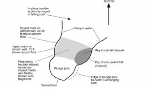
Accurately delineating the area of the deposit is somewhat difficult because of the large number of pre-existing boulders in the impact zone. The deposit from the 9 May rock fall filled a shallow channel that formerly drained the plunge pool and appears to extend 30-40 feet downstream from the northeast edge of the pool.
|
|
The deposit has a maximum width of about 20 feet and averages 2-3 feet in thickness. Scattered freshly broken fragments of rock lay on the ground surrounding the deposit. The total volume of the 9 May deposit appears to have been less than 50 cubic yards. The deposit consisted mainly of rounded, weathered boulders of basalt (lava rock) and a few freshly broken boulder fragments.
|
Figure 5. Sacred Falls rock-fall deposit. |
Soil partially covered some of the deposit and occupied space between the boulders. Pieces of shrubs and small trees that were growing in the source area and along the path of the rock fall made up the remainder of the deposit. The boulders had apparently weathered in place to a rounded shape high on the valley wall prior to falling to the valley floor. Except for the size of the boulders and the covering of loose soil and brush on the deposit, the deposit of the 9 May rock fall looked remarkably similar to the older deposit of boulders at the downstream edge of the plunge pool. Most boulders in the 9 May deposit were smaller than 2 feet across. Many of the boulders in the older deposit were much larger, up to 3-5 feet across.
Several observations on the ground confirm that the landslide material was in free fall during the final part of
its descent and that many rocks bounced on impact. We saw many impact marks and freshly broken rocks on the surface
of the older boulder deposit and on the opposite (northwest) valley wall. We saw two impact marks on the northwest
valley wall, which consisted of rounded, shallow depressions several inches in diameter exposing fresh rock. One
of the marks was about 15 feet above the valley floor and the other was 20-25 feet above the valley floor. It is
unlikely that any of the rocks bounced high enough to make these marks, rather they resulted from impact by airborne
falling rocks. Numerous impact marks were on the valley floor; most consisted of small areas of crushed rock and
small depressions on the faces of basalt boulders. The farthest impact point of a rock from 9 May is about 120
feet downstream from the impact zone (Figure 4).
Causes of the Sacred Falls Landslide
The landslide occurred without triggering from any discernable external conditions. Things that commonly trigger landslide movement include intense or prolonged rainfall, earthquake shaking, recent steepening of a slope, or applying a load to the top of a slope. None of these things occurred prior to the 9 May landslide. The week prior to the slide is reported to have been abnormally dry, and no changes in slope geometry or load have occurred. The smallest earthquake required to trigger this type of slope failure is in the magnitude-4 range (Keefer, 1984), which would have been recorded by local seismic networks and felt strongly throughout the surrounding area, neither of which occurred.
There has been much speculation about the cause of the Sacred Falls landslide. It has been suggested, for example,
that the landslide may have been triggered by sonic booms, low-flying helicopters, or excessive drying of the slope
material. There is no evidence that any of these things caused the landslide of 9 May, and it is highly
unlikely that they could have had any significant effect on the stability of the slope. Although sonic booms and
low-flying aircraft sound loud and powerful, the vibrations they cause in slopes are so minute as to be undetectable.
The vibration caused by Sacred Falls is many times greater than those that would be caused by sonic booms and aircraft.
The idea that drying of slope materials contributed to failure is likewise unfounded: there are no precedents for
landslides occurring because they were too dry. Rather, water is the nemesis of landslides; all other things being
equal, the wetter a slope is, the less stable it becomes.
Many landslides throughout the world occur without a discernable trigger. Slope materials gradually weaken over time under the influence of long-term weathering, infiltration of water, root wedging, and other physical processes. Eventually, if the strength falls below what is necessary to maintain the stability of the slope, a landslide will occur. The timing of such landslides is somewhat random, at least from a human point of view, which indicates that accurate prediction of when such events will occur is impossible.
Current Hazards at Sacred Falls Landslide Site
We saw no indication of additional potential landslide material near the source of the Sacred Falls landslide that appeared particularly likely to fall in the immediate future. The scar is relatively clean and free from loose debris that could come down in the aftermath of the main landslide. There may be additional rock fragments trapped in the vegetation along the landslide track that could come down during rainstorms, but such fragments, if they exist, are probably small and few in number. The overhang created by the landslide is certainly less stable than before the landslide, but it appears to be firmly anchored to the slope, and we saw no fractures or other indications of impending failure. However, this newly created overhang should be periodically inspected for fresh cracks or other indications of potential instability.
Reconnaissance of Kaluanui Gulch
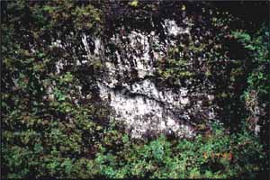
The walls of Kaluanui Gulch show abundant evidence of having produced rock falls over a long period of time. Stable canyon walls become covered with vegetation ranging from a thin layer of fungus or lichen to thick shrubbery; areas that fail and form landslides remove the vegetation and expose fresh rock. We saw a few fresh scars that appeared to be very recent (within a few weeks) at various locations, principally on the southeast wall. Many dozens of scars appeared to be moderately recent (within a few months or years), and evidence of even older scars was also visible.
|
Figure 6. Fairly recent rock-fall scar on the wall of Kaluanui gulch. |
Clearly, rock falls from both walls of the canyon is a common occurrence in both the recent and long-term history of the canyon. The sizes, shapes, and locations of the scars suggests that the Sacred Falls landslide of 9 May was of typical size and form. Some of the scars formed by material falling and leaving overhanging slabs, such as occurred on 9 May, and this creates an area of decreased stability that will eventually fail again.
Deposits in the valley bottom also indicate that rock falls and other landslides are common at and downstream from
Sacred Falls and that these processes have been active for a long time. Most of the trail up the canyon to Sacred
Falls was built on rock-fall and other landslide deposits. These deposits form steep wedges that join the near-vertical
canyon walls to the stream channel in the floor of the valley. The deposits consist of soil and rock fragments
that range in size from pebbles to large boulders. Many of the large boulders deposited by previous rock falls
lie on the ground surface in the midst of a forest of mature trees, which indicates that rock falls have been occurring
in this valley for some time.
Reconnaissance of Maakua Gulch
Maakua Gulch has walls that appear steeper and higher than those of Kaluanui Gulch. We saw several landslide
scars on the canyon walls, but there appeared to be significantly less scars than in Kaluanui Gulch. The vegetation
on the walls of Maakua Gulch appeared to be thicker and more well-developed than in Kaluanui Canyon. Several parts
of the gulch do have areas that have been subject to recent landslides, but other reaches appear to have been more
stable for some time.
Assessment of Landslide Hazards in Kaluanui and Maakua Gulches
Both Kaluanui and Maakua Gulches are areas of very high hazard from rock falls. The canyon walls are hundreds of feet high and are extremely steep (70º-90º), and the valley bottoms are only 50-100 feet wide. The slope material is volcanic rock that weathers deeply and is fractured, which makes it very susceptible to failure. Rock falls can occur either as a result of being triggered by conditions such as intense or prolonged rainfall or earthquake shaking, or in long-term conditions of gradual degradation of slope strength. The narrowness of the valley floors tightly constrains the area of potential impacts and thus increases the likelihood of the rock falls causing damage in the valleys.
Mitigation of Rock-Fall Hazards
Rock-fall hazards can be mitigated in three broad categories: prevention, retention, and set back. Prevention involves selective removal of potential landslide material (scaling) or physically strengthening the slope by using rock bolts, screening, retaining structures, or grouting (cement). This does not appear to be a viable option in this case because of aesthetic concerns (marring the canyon walls) and the practicality of actually getting the necessary equipment to the unstable slopes. Retention involves building retaining structures at the bases of slopes to catch material that falls. Such structures in this case would have to be very strong to catch rocks falling at high speeds from near-vertical, very high slopes. Again, aesthetics and the narrowness of the valley seem to rule out this option: there is simply not enough space at the base of the slopes to build such structures. Set-back involves limiting access to areas near the bases of slopes that are within range of falling and bouncing rocks. This clearly is not possible because the narrowness of the valleys is such that anywhere on the valley floor is within range of falling rocks from either valley wall.
Because none of the possible mitigation measures appears viable, the situation becomes relatively straightforward:
the only way to totally eliminate the possibility of additional landslide-related deaths or injuries is to close
public access to the canyons. If access is allowed, then there is a continuing probability (not yet quantified)
of eventual injuries or fatalities. The fact that very few fatalities have occurred over the past few decades suggests
that this probability, on a per-visit basis, is low, but it is, nonetheless, significant.
Proposed Methods of Detailed Rock-Fall Hazard Assessment
The Sacred Falls rock fall has raised concern about the safety of hiking trails in state parks or other state-managed lands on Oahu. Consequently we were asked to suggest methods of rock-fall hazard assessment for these areas. Field conditions in the steep canyons of Oahu severely limit application of field-based methods, such as the one developed by Harp and Noble (1993), which involves measuring the characteristics of fractures in rock outcrops. Outcrops in Hawaii are commonly steep and inaccessible to a geologist working on the ground, and many are covered by vegetation. Consequently we propose a method that relies mainly on aerial and photographic studies of the areas. This approach is similar to the rock-fall hazard assessment conducted in Yosemite National Park following a fatal rock fall there (Wieczorek and others, 1992, 1998).
A three-phase study could identify hazardous areas along each trail and rank the relative hazards: Phase 1, reconnaissance using aerial photographs; Phase 2, field checking using helicopter- and ground-based observations; and Phase 3, assignment of hazard rankings and identification of areas where rock-fall abatement is feasible. An optional Phase 4 would use records or estimates of trail usage and previous incidents to estimate the probability of hikers being injured or killed by a rock fall or other type of landslide.
Phase 1. Reconnaissance for evidence of active or recent rock fall could be conducted from a study of aerial photographs. Such a study would require vertical and oblique color photographs of the trails and surrounding areas. The photographs should have enough overlap to allow stereoscopic viewing and oblique photographs would be needed for both walls of each canyon. Vertical photographs would be used mainly for viewing canyon bottoms and as an aid in transferring data between the oblique photographs and maps. The oblique photographs would provide a more detailed view of the steep canyon walls than is possible using vertical photographs alone. Scale of the photographs should be large enough to clearly show rock fall scars (source areas and paths) as small as 2-3 feet across (scale of about 1:10,000 or greater). Rock fall areas could be plotted on topographic maps of the area to show their locations relative to the trails. Such photographs would create a record that could be consulted in the future and would significantly reduce the amount of helicopter time needed to map rock-fall evidence along and above the trails. The reconnaissance phase would result in a map showing suspected rock-fall source areas and recent rock-fall paths or tracks.
Phase 2. Field checking from helicopter flights over the trail areas and ground observations along the trails would be used to confirm and correct observations made from the aerial photographs. These observations would be similarbut much more detailedto those we performed in connection with the Sacred Falls rock fall. Ground observations would focus on presence and approximate age of landslide deposits in the valley bottoms and along the trails, and availability of buffer space from possible rock-fall impact areas. Where visibility allowed, the valley walls could be checked for presence or absence of rock-fall scars or potential source areas. Aerial observations would focus on identifying active or recent scars and potential rock-fall source areas as well as recent rock-fall tracks. These ground and aerial field observations would be compared directly to the preliminary map of rock-fall areas from Phase 1 and would result in a revised map of rock-fall source areas and recent scars and tracks. This phase would also result in qualitative estimates of the frequency or relative ages of rock falls in the area.
Phase 3. Assignment of hazard rankings would be based on factors observed in the previous phases. These
include relative abundance of rock-fall scars and potential source areas and the relative age or frequency of rock-fall
activity. Hazard increases with opportunity for rock fall to occur. Thus, abundant fresh and recent rock-fall scars
characterize high hazard zones, absence of fresh or recent scars and other potential rock-fall source areas characterize
low hazard zones. Intermediate zones can be defined as needed to subdivide the range of observed rock fall abundance
and frequency between the high and low hazard zones.
Once rock-fall hazard near the trails has been classified, segments of trails near high-hazard zones can be considered
for various types rock-fall mitigation. As discussed above in the section on mitigation of rock-fall hazards, several
methods are available, but only a few may be feasible along segments of most trails. Selective removal of loose
or overhanging rock may be feasible in a few areas, but in general would be very difficult in steep, high-walled
canyons. Where space allows, trails may be relocated to move them away from high hazard zones. Buffer zones can
be defined by mapping the extent of rock-fall deposits downslope from active rock-fall areas, and trails may be
rerouted beyond the edge of the deposits, provided the new route is acceptable on other grounds.
Phase 4. Estimates of probability of fatalities or injury could be used to aid in decisions about closing a trail or keeping it open to hikers. The first step in this phase would be to decide upon an acceptable level of risk (on a per-visit basis, how many rock-fall related injuries or deaths is DLNR and the community willing to accept). The next step is to estimate the likelihood of an injury or fatality based on existing conditions and the historic number of incidents. For example, to estimate the rate of fatalities due to rock fall at Sacred Falls, divide the total number of fatalities on record by the total number of visitors since records on such incidents have been kept (not just since the first rock-fall incident). Per-visit rates of fatalities and injuries can be compared to other statistics as an aid in determining how risky hiking a given canyon or trail is compared with other activities. It also provides a means of comparing the relative risk of different trails.
Summary and Conclusions
The Sacred Falls landslide of 9 May 1999 involved a very small volume (~50 cubic yards) of weathered rock, soil, and vegetation that plunged nearly 500 feet onto a narrowly constricted canyon floor that was crowded with visitors. One lesson to be learned from this event is that very small landslides can cause catastrophic results if they occur in times and places where many people are present. The following conclusions can be made in light of our observations and expertise:
References
Harp, E.L., and Noble, M.A., 1993, An engineering rock classification to evaluate seismic rock-fall susceptibility and its application to the Wasatch Front: Bulletin of the Association of Engineering Geologists, v. 30, p. 293-319.
Keefer, D.K., 1984, Landslides caused by earthquakes: Geological Society of America Bulletin, v. 95, p. 406-421.
Wieczorek, G.F., Morrissey, M.M., Iovine, G., and Godt, J., 1998, Rock-fall hazards in the Yosemite Valley: U.S.
Geological Survey Open-file Report 98-467, 1:12,000.
Wieczorek, G.F., Snyder, J.B., Alger, C.S., and Isaacson, K.A., 1992, Rock falls in Yosemite Valley, California:
U.S. Geological Survey Open-File Report 92-387, 38 p., 2 app., 4 pl., 1 disk.
| AccessibilityFOIAPrivacyPolicies and Notices | |
| |
|