Land and Federal mineral ownership coverage for northwestern
Colorado
|
 |
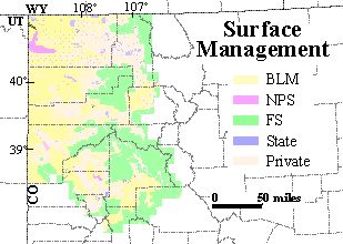
This Arc/Info coverage contains land status and Federal mineral ownership
for approximately 26,800 square miles in northwestern Colorado. The polygon
coverage (which is also provided here as a shapefile) contains two attributes
of ownership information for each polygon. One attribute indicates
where the surface is State owned, privately owned, or, if Federally owned,
which Federal agency manages the land surface. The other attribute
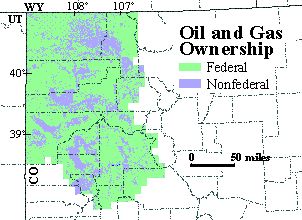
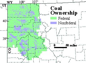
indicates which minerals, if any, are owned by the Federal govenment. This
coverage is based on land status and Federal mineral ownership data compiled
by the U.S. Geological Survey (USGS) and three Colorado State Bureau of
Land Management (BLM) former district offices at a scale of 1:24,000.
This coverage was compiled primarily to serve the USGS National Oil and
Gas Resource Assessment Project in the Uinta-Piceance Basin Province and
the USGS National Coal Resource Assessment Project in the Colorado Plateau.
Download the Arc/Info EXPORT file http://greenwood.cr.usgs.gov/pub/open-file-reports/ofr-99-0553-a/nwcoown.e00
{NOTE: to download rather than open the file, right mouse click on the
filename. This opens a window from which the user selects 'Save Link
As...' (Netscape Navigator) or 'Save Target As...' (Internet Explorer)
to save the file to the desired location. Approximate file size is
11 MB.}
Download the shapefile and ArcView project file http://greenwood.cr.usgs.gov/pub/open-file-reports/ofr-99-0553-a/nwcoown.zip.
The shapefile (5 files) and a .apr file for ArcView3.1 are contained in
a WinZip file. {NOTE: right mouse click on the filename. This opens
a window from which the user selects 'Save Link As...' (Netscape Navigator)
or 'Save Target As...' (Internet Explorer) to save the file to the desired
location. A left mouse click sends the file to c:\My Downloadable
Files. Approximate file size of the WinZip file is 4.9 MB;
once extracted, the files use approximately 12.3 MB of space.}
Download the metadata in text format that is FGDC compliant http://greenwood.cr.usgs.gov/pub/open-file-reports/ofr-99-0553-a/nwcoown.met.
(Approximate file size is 48 KB.)
Disclaimer: The surface and mineral management status are published
as general planning and management tools. The official land records in
Bureau of Land Management (BLM) offices or other Federal and/or State agencies
should be checked for status of specific tracts of land. Comparison with
other data sets on surface and mineral ownership for the same area from
other time periods may reveal inconsistencies resulting from changes in
land and mineral ownership or in mapping conventions over time. This data
is not a legal document and is not intended to be used as such. Any use
of trade, product, or company names in this publication is for descriptive
purposes only and does not imply endorsement by the U.S. Government.
Metadata:
|
 |
-
Identification_Information:
-
Citation:
-
Citation_Information:
-
Originator: U.S. Geological Survey
-
Originator: Biewick, L.R.H.
-
Originator: Mercier, T.J.
-
Originator: Bureau of Land Management
-
Originator: Taylor, D.
-
Originator: Levitt, P.
-
Originator: Deikman, D.
-
Originator: Vlahos, B.
-
Publication_Date: 1999
-
Title:
-
nwcoown (Land and Federal mineral ownership coverage for northwestern Colorado)
-
Geospatial_Data_Presentation_Form: map
-
Publication_Information:
-
Publication_Place: Denver, CO
-
Publisher: U.S. Geological Survey
-
Online_Linkage: <http://greenwood.cr.usgs.gov/pub/open-file-reports/ofr-99-0553-a/>
-
Description:
-
Abstract:
-
This Arc/Info coverage contains land status and Federal mineral ownership
for approximately 26,800 square miles in northwestern Colorado. The polygon
coverage (which is also provided here as a shapefile) contains two attributes
of ownership information for each polygon. One attribute indicates
where the surface is State owned, privately owned, or, if Federally owned,
which Federal agency manages the land surface. The other attribute
indicates which minerals, if any, are owned by the Federal govenment. This
coverage is based on land status and Federal mineral ownership data compiled
by the U.S. Geological Survey (USGS) and three Colorado State Bureau of
Land Management (BLM) former district offices at a scale of 1:24,000.
This coverage was compiled primarily to serve the USGS National Oil and
Gas Resource Assessment Project in the Uinta-Piceance Basin Province and
the USGS National Coal Resource Assessment Project in the Colorado Plateau.
-
Purpose:
-
As United States energy resources continue to be examined for potential
development, there is sustained interest in Federally owned energy resources
in the western United States. The U.S. Geological Survey's GIS data sets
of surface and Federal mineral ownership, joined with USGS geologic investigations,
provides information on where Federally owned energy resources are located
and how much Federal petroleum and coal exists. These ownership and resource
data are the basis for answering complex geospatial queries when the data
are combined with quality, structure and other parameters generated from
geologic investigations. Combining information on land status, Federal
mineral status, and geology helps policy makers and land-use planners make
informed decisions regarding use of Federal land and energy resources to
meet diverse social needs.
-
Surface ownership can differ from energy and other mineral ownership for
the same piece of land. For example, the oil and gas may be Federally owned,
but the surface may be under the jurisdiction or management of State, Tribal,
or private groups. This separation of jurisdiction may have legal ramifications
in the development or non-development of energy resources.
-
The U. S. Geological Survey (USGS), in cooperation with the Bureau of Land
Management (BLM) and State agencies, is collecting ownership files and
compiling them in Arc/Info coverages. The coverages contain a USGS standardized
attributing scheme and are stored in a data library where they are accessed
and combined with models of oil, gas and coal geology to assess National
energy resources (see information from the U.S. Geological Survey available
on 10/5/99 on the World Wide Web at <URL:http://energy.cr.usgs.gov/fedland/FS12-98/>
and at <URL:http://greenwood.cr.usgs.gov/pub/fact-sheets/fs-0145-99>).
Similar data are available for northeastern Utah (see <http://greenwood.cr.usgs.gov/pub/open-file-reports/ofr-99-0553-b/>)
primarily to serve the U.S. Geological Survey National Oil and Gas Resource
Assessment Project in the Uinta-Piceance Basin (province 20) and in southern
Wyoming (see <http://greenwood.cr.usgs.gov/pub/open-file-reports/ofr-99-0553-c/>)
for portions of provinces 36, 37 and 39.
-
The Federally owned energy resources play an important role in supplying
energy to our Nation. Of the 26 million acres of Federal Mineral Estate
in Colorado, 20 million acres are open to oil and gas leasing (information
from the Bureau of Land Management available on 9/10/99 on the World Wide
Web at <URL:http://www.co.blm.gov/oilandgas/stats.htm>).
In 1998, 1.37 million acres of Public Lands in Colorado were in producing
status with 2,387 producing oil and gas wells. Coal production from 28
leases on Public Lands in Colorado was over 22.8 million short tons in
1998. Federally owned energy resources also play an important part in the
economy of our Nation. 1998 Federal mineral royalties, rents, and bonuses
produced financial transfers to Colorado of over $43 million, and the Federal
collections were over $90 million (information from the Bureau of Land
Management available on 9/10/99 on the World Wide Web at
<URL:http://www.blm.gov:80/nhp/pubs/rewards/1999/5co.htm>).
-
Time_Period_of_Content:
-
Time_Period_Information:
-
Single_Date/Time:
-
Calendar_Date: 19990910
-
Currentness_Reference: completion date
-
Status:
-
Progress: Complete
-
Maintenance_and_Update_Frequency: Unknown
-
Spatial_Domain:
-
Bounding_Coordinates:
-
West_Bounding_Coordinate: -109.0596
-
East_Bounding_Coordinate: -106.1250
-
North_Bounding_Coordinate: 41.0035
-
South_Bounding_Coordinate: 37.7500
-
Keywords:
-
Theme:
-
Theme_Keyword_Thesaurus: None
-
Theme_Keyword: Piceance Basin
-
Theme_Keyword: Federal mineral ownership
-
Theme_Keyword: Sand Wash Basin
-
Theme_Keyword: land status
-
Theme_Keyword: land ownership
-
Theme_Keyword: land-use planning
-
Theme_Keyword: Federal coal ownership
-
Theme_Keyword: Federal oil and gas ownership
-
Theme_Keyword: Federal surface management
-
Theme_Keyword: Surface management
-
Theme_Keyword: Public lands
-
Place:
-
Place_Keyword_Thesaurus: None
-
Place_Keyword: Piceance Basin
-
Place_Keyword: northwestern Colorado
-
Place_Keyword: western United States
-
Place_Keyword: Sand Wash Basin
-
Place_Keyword: Colorado Plateau
-
Place_Keyword: Province 20
-
Place_Keyword: Uinta-Piceance Basin Province
-
Temporal:
-
Temporal_Keyword_Thesaurus: None
-
Temporal_Keyword: 1999
-
Access_Constraints: None
-
Use_Constraints:
-
The surface and mineral management status are published as general planning
and management tools. The official land records in Bureau of Land Management
(BLM) offices or other Federal and/or State agencies should be checked
for status of specific tracts of land. Comparison with other data sets
on surface and mineral ownership for the same area from other time periods
may reveal inconsistencies resulting from changes in land and mineral ownership
or in mapping conventions over time.
-
Point_of_Contact:
-
Contact_Information:
-
Contact_Person_Primary:
-
Contact_Person: Laura R.H. Biewick
-
Contact_Organization: U.S. Geological Survey
-
Contact_Position: Geologist
-
Contact_Address:
-
Address_Type: mailing and physical address
-
Address: P.O. Box 25046, MS 939
-
City: Denver
-
State_or_Province: CO
-
Postal_Code: 80225-0046
-
Country: USA
-
Contact_Voice_Telephone: (303) 236-7773
-
Contact_Facsimile_Telephone: (303) 236-0459
-
Contact_Electronic_Mail_Address: lbiewick@usgs.gov
-
Data_Set_Credit:
-
Others who contributed toward the completion of these data include: Buchanan,
R., Fowler, B., Hackett, V., Senti, A., Wells, R., Wilkenson, J., and Witherby,
K.
-
Native_Data_Set_Environment:
-
Arc/Info Version 7.2.1 on Windows NT operating system
-
Data_Quality_Information:
-
Attribute_Accuracy:
-
Attribute_Accuracy_Report:
-
This coverage was created by performing UNIONs, MAPJOINs and APPENDs in
Arc/Info of multiple ownership coverages obtained from the BLM between
1996 and 1999. The USGS processed surface and Federal mineral ownership
coverages from the Colorado State BLM office and three Colorado BLM former
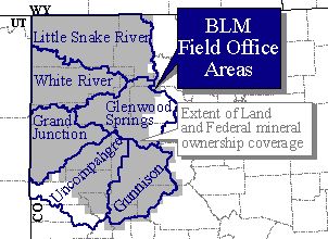
district offices for the following field office areas: Little Snake River
(LSFO), White River (WRFO), Glenwood Springs (GSFO), Grand Junction (GJFO)
and Montrose (MFO). The land and mineral ownership coverages were combined
in Arc/Info using the UNION command and slivers where deleted as needed.
Attributes were added and populated in accordance with the standard attributing
scheme developed by the USGS for land status and minerals owned by the
Federal Government (see information from the U.S. Geological Survey available
on 10/5/99 on the World Wide Web at <URL:http://energy.cr.usgs.gov/fedland/FS12-98/part4.html>).
In places where there was overlap or ownership was unknown, we honored
the published BLM hardcopy maps and/or obtained updated information from
the BLM. Areas of overlap between the districts were ERASEd in Arc/Info
prior to performing the APPEND command. The coverage was then DISSOLVEd
to ensure unique polygons for the attributes that define surface and Federal
mineral ownership. Approximate accuracy is 90%.
-
Logical_Consistency_Report: topologically clean, 9/10/99, Arc/Info
-
Completeness_Report:
-
This coverage is based on land status and Federal mineral ownership data
compiled by the USGS and three Colorado BLM former district offices at
a scale of 1:24,000. Arcs were snapped to the GCDB (Geographic Coordinate
Database) landlines where available.
-
Lineage:
-
Source_Information:
-
Source_Citation:
-
Citation_Information:
-
Originator: Bureau of Land Management
-
Publication_Date: 19930000
-
Title:
-
Surface Management Status
-
Mineral Management Status
-
Colorado
-
Canyon of Lodore
-
Geospatial_Data_Presentation_Form: map
-
Source_Scale_Denominator: 100,000
-
Type_of_Source_Media: paper map
-
Source_Time_Period_of_Content:
-
Time_Period_Information:
-
Single_Date/Time:
-
Calendar_Date: 19930000
-
Source_Currentness_Reference: publication date
-
Source_Citation_Abbreviation: BLM, 1993
-
Source_Contribution:
-
Land and mineral ownership in the Canyon of Lodore 30- x 60-minute quadrangle,
Colorado.
-
Source_Information:
-
Source_Citation:
-
Citation_Information:
-
Originator: Bureau of Land Management
-
Publication_Date: 19940000
-
Title:
-
Surface Management Status
-
Mineral Management Status
-
Colorado
-
Carbondale
-
Geospatial_Data_Presentation_Form: map
-
Source_Scale_Denominator: 100,000
-
Type_of_Source_Media: paper map
-
Source_Time_Period_of_Content:
-
Time_Period_Information:
-
Single_Date/Time:
-
Calendar_Date: 19940000
-
Source_Currentness_Reference: publication date
-
Source_Citation_Abbreviation: BLM, 1994
-
Source_Contribution:
-
Land and mineral ownership in the Carbondale 30- x 60-minute quadrangle,
Colorado.
-
Source_Information:
-
Source_Citation:
-
Citation_Information:
-
Originator: Bureau of Land Management
-
Publication_Date: 19970000
-
Title:
-
Surface Management Status
-
Mineral Management Status
-
Colorado
-
Craig
-
Geospatial_Data_Presentation_Form: map
-
Source_Scale_Denominator: 100,000
-
Type_of_Source_Media: paper map
-
Source_Time_Period_of_Content:
-
Time_Period_Information:
-
Single_Date/Time:
-
Calendar_Date: 19970000
-
Source_Currentness_Reference: publication date
-
Source_Citation_Abbreviation: BLM, 1997
-
Source_Contribution:
-
Land and mineral ownership in the Craig 30- x 60-minute quadrangle, Colorado.
-
Source_Information:
-
Source_Citation:
-
Citation_Information:
-
Originator: Bureau of Land Management
-
Publication_Date: 19920000
-
Title:
-
Surface Management Status
-
Mineral Management Status
-
Colorado
-
Delta
-
Geospatial_Data_Presentation_Form: map
-
Source_Scale_Denominator: 100,000
-
Type_of_Source_Media: paper map
-
Source_Time_Period_of_Content:
-
Time_Period_Information:
-
Single_Date/Time:
-
Calendar_Date: 19920000
-
Source_Currentness_Reference: publication date
-
Source_Citation_Abbreviation: BLM, 1992
-
Source_Contribution:
-
Land and mineral ownership in the Delta 30- x 60-minute quadrangle, Colorado.
-
Source_Information:
-
Source_Citation:
-
Citation_Information:
-
Originator: Bureau of Land Management
-
Publication_Date: 19940000
-
Title:
-
Surface Management Status
-
Mineral Management Status
-
Colorado
-
Douglas Pass
-
Geospatial_Data_Presentation_Form: map
-
Source_Scale_Denominator: 100,000
-
Type_of_Source_Media: paper map
-
Source_Time_Period_of_Content:
-
Time_Period_Information:
-
Single_Date/Time:
-
Calendar_Date: 19940000
-
Source_Currentness_Reference: publication date
-
Source_Citation_Abbreviation: BLM, 1994
-
Source_Contribution:
-
Land and mineral ownership in the Douglas Pass 30- x 60-minute quadrangle,
Colorado.
-
Source_Information:
-
Source_Citation:
-
Citation_Information:
-
Originator: Bureau of Land Management
-
Publication_Date: 19940000
-
Title:
-
Surface Management Status
-
Mineral Management Status
-
Colorado
-
Glenwood Springs
-
Geospatial_Data_Presentation_Form: map
-
Source_Scale_Denominator: 100,000
-
Type_of_Source_Media: paper map
-
Source_Time_Period_of_Content:
-
Time_Period_Information:
-
Single_Date/Time:
-
Calendar_Date: 19940000
-
Source_Currentness_Reference: publication date
-
Source_Citation_Abbreviation: BLM, 1994
-
Source_Contribution:
-
Land and mineral ownership in the Glenwood Springs 30- x 60-minute quadrangle,
Colorado.
-
Source_Information:
-
Source_Citation:
-
Citation_Information:
-
Originator: Bureau of Land Management
-
Publication_Date: 19950000
-
Title:
-
Surface Management Status
-
Mineral Management Status
-
Colorado
-
Grand Junction
-
Geospatial_Data_Presentation_Form: map
-
Source_Scale_Denominator: 100,000
-
Type_of_Source_Media: paper map
-
Source_Time_Period_of_Content:
-
Time_Period_Information:
-
Single_Date/Time:
-
Calendar_Date: 19950000
-
Source_Currentness_Reference: publication date
-
Source_Citation_Abbreviation: BLM, 1995
-
Source_Contribution:
-
Land and mineral ownership in the Grand Junction 30- x 60-minute quadrangle,
Colorado.
-
Source_Information:
-
Source_Citation:
-
Citation_Information:
-
Originator: Bureau of Land Management
-
Publication_Date: 19930000
-
Title:
-
Surface Management Status
-
Mineral Management Status
-
Colorado
-
Gunnison
-
Geospatial_Data_Presentation_Form: map
-
Source_Scale_Denominator: 100,000
-
Type_of_Source_Media: paper map
-
Source_Time_Period_of_Content:
-
Time_Period_Information:
-
Single_Date/Time:
-
Calendar_Date: 19930000
-
Source_Currentness_Reference: publication date
-
Source_Citation_Abbreviation: BLM, 1993
-
Source_Contribution:
-
Land and mineral ownership in the Gunnison 30- x 60-minute quadrangle,
Colorado.
-
Source_Information:
-
Source_Citation:
-
Citation_Information:
-
Originator: Bureau of Land Management
-
Publication_Date: 19930000
-
Title:
-
Surface Management Status
-
Mineral Management Status
-
Colorado
-
Meeker
-
Geospatial_Data_Presentation_Form: map
-
Source_Scale_Denominator: 100,000
-
Type_of_Source_Media: paper map
-
Source_Time_Period_of_Content:
-
Time_Period_Information:
-
Single_Date/Time:
-
Calendar_Date: 19930000
-
Source_Currentness_Reference: publication date
-
Source_Citation_Abbreviation: BLM, 1993
-
Source_Contribution:
-
Land and mineral ownership in the Meeker 30- x 60-minute quadrangle, Colorado.
-
Source_Information:
-
Source_Citation:
-
Citation_Information:
-
Originator: Bureau of Land Management
-
Publication_Date: 19970000
-
Title:
-
Surface Management Status
-
Mineral Management Status
-
Colorado
-
Montrose
-
Geospatial_Data_Presentation_Form: map
-
Source_Scale_Denominator: 100,000
-
Type_of_Source_Media: paper map
-
Source_Time_Period_of_Content:
-
Time_Period_Information:
-
Single_Date/Time:
-
Calendar_Date: 19970000
-
Source_Currentness_Reference: publication date
-
Source_Citation_Abbreviation: BLM, 1997
-
Source_Contribution:
-
Land and mineral ownership in the Montrose 30- x 60-minute quadrangle,
Colorado.
-
Source_Information:
-
Source_Citation:
-
Citation_Information:
-
Originator: Bureau of Land Management
-
Publication_Date: 19920000
-
Title:
-
Surface Management Status
-
Mineral Management Status
-
Colorado
-
Nucla
-
Geospatial_Data_Presentation_Form: map
-
Source_Scale_Denominator: 100,000
-
Type_of_Source_Media: paper map
-
Source_Time_Period_of_Content:
-
Time_Period_Information:
-
Single_Date/Time:
-
Calendar_Date: 19920000
-
Source_Currentness_Reference: publication date
-
Source_Citation_Abbreviation: BLM, 1992
-
Source_Contribution:
-
Land and mineral ownership in the Nucla 30- x 60-minute quadrangle, Colorado.
-
Source_Information:
-
Source_Citation:
-
Citation_Information:
-
Originator: Bureau of Land Management
-
Publication_Date: 19950000
-
Title:
-
Surface Management Status
-
Mineral Management Status
-
Colorado
-
Paonia
-
Geospatial_Data_Presentation_Form: map
-
Source_Scale_Denominator: 100,000
-
Type_of_Source_Media: paper map
-
Source_Time_Period_of_Content:
-
Time_Period_Information:
-
Single_Date/Time:
-
Calendar_Date: 19950000
-
Source_Currentness_Reference: publication date
-
Source_Citation_Abbreviation: BLM, 1995
-
Source_Contribution:
-
Land and mineral ownership in the Paonia 30- x 60-minute quadrangle, Colorado.
-
Source_Information:
-
Source_Citation:
-
Citation_Information:
-
Originator: Bureau of Land Management
-
Publication_Date: 19920000
-
Title:
-
Surface Management Status
-
Mineral Management Status
-
Colorado
-
Rangely
-
Geospatial_Data_Presentation_Form: map
-
Source_Scale_Denominator: 100,000
-
Type_of_Source_Media: paper map
-
Source_Time_Period_of_Content:
-
Time_Period_Information:
-
Single_Date/Time:
-
Calendar_Date: 19920000
-
Source_Currentness_Reference: publication date
-
Source_Citation_Abbreviation: BLM, 1992
-
Source_Contribution:
-
Land and mineral ownership in the Rangely 30- x 60-minute quadrangle, Colorado.
-
Source_Information:
-
Source_Citation:
-
Citation_Information:
-
Originator: Bureau of Land Management
-
Publication_Date: 19980000
-
Title:
-
Surface Management Status
-
Mineral Management Status
-
Colorado
-
Saguache
-
Geospatial_Data_Presentation_Form: map
-
Source_Scale_Denominator: 100,000
-
Type_of_Source_Media: paper map
-
Source_Time_Period_of_Content:
-
Time_Period_Information:
-
Single_Date/Time:
-
Calendar_Date: 19980000
-
Source_Currentness_Reference: publication date
-
Source_Citation_Abbreviation: BLM, 1998
-
Source_Contribution:
-
Land and mineral ownership in the Saguache 30- x 60-minute quadrangle,
Colorado.
-
Source_Information:
-
Source_Citation:
-
Citation_Information:
-
Originator: Bureau of Land Management
-
Publication_Date: 19900000
-
Title:
-
Surface Management Status
-
Mineral Management Status
-
Colorado
-
Silverton
-
Geospatial_Data_Presentation_Form: map
-
Source_Scale_Denominator: 100,000
-
Type_of_Source_Media: paper map
-
Source_Time_Period_of_Content:
-
Time_Period_Information:
-
Single_Date/Time:
-
Calendar_Date: 19900000
-
Source_Currentness_Reference: publication date
-
Source_Citation_Abbreviation: BLM, 1990
-
Source_Contribution:
-
Land and mineral ownership in the Silverton 30- x 60-minute quadrangle,
Colorado.
-
Source_Information:
-
Source_Citation:
-
Citation_Information:
-
Originator: Bureau of Land Management
-
Publication_Date: 19970000
-
Title:
-
Surface Management Status
-
Mineral Management Status
-
Colorado
-
Steamboat Springs
-
Geospatial_Data_Presentation_Form: map
-
Source_Scale_Denominator: 100,000
-
Type_of_Source_Media: paper map
-
Source_Time_Period_of_Content:
-
Time_Period_Information:
-
Single_Date/Time:
-
Calendar_Date: 19970000
-
Source_Currentness_Reference: publication date
-
Source_Citation_Abbreviation: BLM, 1997
-
Source_Contribution:
-
Land and mineral ownership in the Steamboat Springs 30- x 60-minute quadrangle,
Colorado.
-
Source_Information:
-
Source_Citation:
-
Citation_Information:
-
Originator: Bureau of Land Management
-
Publication_Date: 19970000
-
Title:
-
Surface Management Status
-
Mineral Management Status
-
Colorado
-
Walden
-
Geospatial_Data_Presentation_Form: map
-
Source_Scale_Denominator: 100,000
-
Type_of_Source_Media: paper map
-
Source_Time_Period_of_Content:
-
Time_Period_Information:
-
Single_Date/Time:
-
Calendar_Date: 19970000
-
Source_Currentness_Reference: publication date
-
Source_Citation_Abbreviation: BLM, 1997
-
Source_Contribution:
-
Land and mineral ownership in the Walden 30- x 60-minute quadrangle, Colorado.
-
Process_Step:
-
Process_Description:
-
Land and Federal mineral ownership files from three Colorado State BLM
former district offices (Craig, Grand Junction and Montrose) were initially
processed by the USGS to create ownership coverages that were used for
the USGS Geologic Assessment of Coal in the Colorado Plateau Project (see
information from the U.S. Geological Survey available on 10/5/99 on the
World Wide Web at <URL:http://energy.cr.usgs.gov/coal/>).
The coal assessment areas in northwestern Colorado include the Danforth
Hills and Yampa coal fields, the Deserado coal area and the southern Piceance
Basin (see information from the U.S. Geological Survey available on 10/5/99
on the World Wide Web at <URL:http://energy.cr.usgs.gov/coal/rocky2.html>).
Digital files obtained from the BLM offices were in Arc/Info EXPORT format.
1:24,000-scale coverages of surface and mineral ownership were used from
the Craig, Grand Junction and Montrose BLM former district offices for
the following field office areas: White River, Glenwood Springs, Grand
Junction, Little Snake River, Gunnison and Uncompahgre. The files were
imported and combined using the UNION command and either the MAPJOIN or
the APPEND commands to create ownership coverages for each of the coal
assessment areas listed above (see information from the U.S. Geological
Survey available on 10/5/99 on the World Wide Web at <URL:http://greenwood.cr.usgs.gov/pub/fact-sheets/fs-0145-99>).
The union of coverages of dissimilar landlines produced an inordinate amount
of sliver polygons. This problem was resolved by several different methods.
The processing to remove slivers from the integrated land and Federal mineral
ownership coverages was done using an Arc Macro Language (AML) program
(deleteslivers.aml), the Arc/Info ELIMINATE command, and Arcedit. In places
where digital files from the various BLM field offices overlapped, we honored
the most current data or matched the published BLM hardcopy maps. Areas
of overlap were ERASEd in Arc/Info prior to performing the APPEND command
to combine adjacent files. The coverages were then clipped to the coal
assessment study area boundaries and items (fields) were added for storage
of ownership data according to the USGS surface and mineral management
status attributing scheme, as follows --
-
Arc: additem SURF 8 8 c
-
Arc: additem FEDMINS 8 8 c
-
The item SURF defines surface management status in each polygon. The item,
FEDMINS, holds Federal mineral ownership information. The items (fields)
SURF and FEDMINS were populated based on the surface and mineral ownership
attributes provided in the BLM coverages. The coverages were then DISSOLVEd
with the #all and poly options to remove extraneous lines and to ensure
unique polygons for the attributes SURF and FEDMINS.
-
Process_Date: 19990000
-
Process_Contact:
-
Contact_Information:
-
Contact_Person_Primary:
-
Contact_Person: Laura R.H. Biewick
-
Contact_Organization: U.S. Geological Survey
-
Contact_Position: geologist
-
Contact_Address:
-
Address_Type: mailing and physical address
-
Address: P.O. Box 25046, MS 939
-
City: Denver
-
State_or_Province: CO
-
Postal_Code: 80225-0046
-
Country: USA
-
Contact_Voice_Telephone: (303) 236-7773
-
Contact_Facsimile_Telephone: (303) 236-0459
-
Contact_Electronic_Mail_Address: lbiewick@usgs.gov
-
Process_Step:
-
Process_Description:
-
In 1999, the USGS processed ownership beyond the coal assessment areas
to create one seamless coverage for northwestern Colorado. The coverage,
'nwcoown', includes the areas where Oil and Gas Plays will be assessed
for the USGS Uinta-Piceance Basin Oil and Gas Assessment. In August, 1999,
new files were received from the BLM by the USGS for Federal mineral ownership
in the Grand Junction and former Glenwood Springs District Office areas
and for surface ownership in the Glenwood Springs, Gunnison, Uncompahgre,
and Little Snake River Field Office areas. These BLM files were used to
update and expand the areal extent of the USGS ownership coverage in northwestern
Colorado ('nwcoown').
-
Processing of the BLM files included:
-
1. Importing and projecting BLM coverages to geographic decimal degrees.
-
2. Extension or clipping of data to Colorado statelines to the north and
west to match adjacent coverages in northeastern Utah (in press) and southern
Wyoming (in press).
-
3. Referencing the new data to update the northwest Colorado ownership
coverage ('nwcoown'). The surface ownership information in 'nwcoown' was
modified to match the more recent data acquired from the BLM former Craig
District Office for the Little Snake River Field Office area ('lsra_surf')
and from the BLM former Montrose District Office for the Gunnison and Uncompahgre
Field Office area ('mont_surf'). The mineral ownership information in 'nwcoown'
was modified to match the current data acquired from the BLM former Grand
Junction District Office for the Grand Junction Field Office area ('gjra_subs').
The mineral ownership file for the Gunnison and Uncompahgre Field Office
areas ('mont_subs') is based on work done by the BLM in the late 1980s.
Because the data is somewhat outdated, not quality controlled by the BLM
and much of the area was not attributed to show Federal mineral ownership,
the USGS attributed FEDMINS based on the published BLM hardcopy maps. These
data were then INTERSECTed with the Montrose surface ownership coverage
and APPENDed to 'nwcoown' after it was extensively edited to remove slivers,
dangles and intersections.
-
4. Processing the new files to replace data in the northwest Colorado ownership
coverage. This included adding and populating the items SURF and FEDMINS
based on items in fields STATUS and MNO in the Glenwood Springs Field Office
area ownership file ('grsa_own'). The Arc/Info FREQUENCY command was used
as a means of checking the data before removing items and using the DISSOLVE
command. 'gsra_own' was edited to remove slivers and all extraneous pseudonodes
were eliminated before incorporating this data into 'nwcoown' using the
UPDATE command.
-
Commands used to process 'nwcoown' as needed included CLEAN, BUILD, LABELERRORS,
DROPITEM, DISSOLVE, UNSPLIT NONE, UPDATE. The polygon attribute table ('nwcoown.pat')
was corrected using ArcView table editting tools. To facilitate this process
of locating and correcting line and polygon discrepancies between 'nwcoown'
and new data from the BLM, arcs and labels in a copy of 'nwcoown' were
editted in Arcedit while viewing 'nwcoown' in comparison to the original
BLM files in ArcView.
-
This data set has gone through extensive processing to eliminate slivers.
Polygon topology exists and there are no label errors. Although the intent
is to publish a coverage free of errors, it is possible that nondetection
of some slivers may have occurred. Such detection of additional slivers
would only be possible in working with portions of this data at a larger
scale than 1:24,000-scale. Another dissolve following manual elimination
of slivers resulted in 'nwcoown' containing 8650 polygons (18951 arcs).
The coverage was carefully checked against the original BLM coverages in
ArcView and edited as necessary in ArcView and Arcedit. Extraneous pseudonodes
have been deleted.
-
Process_Date: 19990000
-
Process_Contact:
-
Contact_Information:
-
Contact_Person_Primary:
-
Contact_Person: Laura R.H. Biewick
-
Contact_Organization: U.S. Geological Survey
-
Contact_Position: geologist
-
Contact_Address:
-
Address_Type: mailing and physical address
-
Address: P.O. Box 25046, MS 939
-
City: Denver
-
State_or_Province: CO
-
Postal_Code: 80225-0046
-
Country: USA
-
Contact_Voice_Telephone: (303) 236-7773
-
Contact_Facsimile_Telephone: (303) 236-0459
-
Contact_Electronic_Mail_Address: lbiewick@usgs.gov
-
Process_Step:
-
Process_Description:
-
For those interested in coverage processing details: Past tests using the
Arc/Info CLEAN command to collapse sliver polygons proved to be unsuccessful.
In the process of collapsing slivers, the CLEAN command creates numerous
(hundreds of) new polygons that contain no label points and therefore have
lost the attribute information (i.e., corners of polygons become collapsed).
Because of the magnitude of work involved in adding the attribute information
back into the coverage, it is suggested that the tedious process of manual
editing of slivers is of equal or less magnitude and possibly introduces
less error. The manual editing process was performed systematically by
100,000-scale quadrangle until all node errors and obvious polygon errors
were corrected. The time involved in this manual editing process ranged
from 30 minutes to several hours per 100,000-scale quadrangle. The coverage
was rebuilt for topology several times as necessary.
-
One procedure used is as follows -- In Arcedit, drawsel all polygons with
areas lt .00001 decimal degrees. Create a window as big as one 100,000-scale
quadrangle. It works well on a 21-inch screen to divide the 100,000-scale
quadrangle into twelfths to zoom in and check the data. Create further
zoomed-in windows as needed for more detail of suspect slivers. In this
process, other slivers that may not be highlighted (selected polygons),
are also found. Proceed through the entire 30- by 60-minute quadrangle
by panning across and down, minimizing windows of slivered areas. When
finished analyzing the selected polygons in the entire 30- by 60-minute
quadrangle, change edit feature to arc (now selected polygons disappear).
Maximize the windows that contain slivers one by one to edit arcs and labels.
Also selected were arcs that are sliver extensions of polygons. Sometimes
these arcs, when selected, are found to overlap other arcs. The draw environment
needs to be arc, label, node errors and sometimes arc intersects. Set arcsnap
on. Labels help identify minute slivers that would not otherwise be detected.
The arcs that make up these slivers can be selected with edit feature arc,
by selecting directly on the label, deleting the arcs and subsequently
deleting the labels. Use the command intersectarcs all. Continue this process
of selecting arcs, splitting where needed, reselecting, deleting, and moving
nodes to close polygons where dangles are created in the process. Always
display arcs and labels; they go hand in hand in defining polygons (even
sliver polygons). Both arcs and labels need to be deleted to avoid numerous
labelerrors that can result in incorrect attributes associated with polygons.
After zooming into detected slivered areas and fixing them, gradually zoom
out to facilitate identification and deletion of additional sliver problems.
-
Process_Date: 19990000
-
Process_Contact:
-
Contact_Information:
-
Contact_Person_Primary:
-
Contact_Person: Laura R.H. Biewick
-
Contact_Organization: U.S. Geological Survey
-
Contact_Position: geologist
-
Contact_Address:
-
Address_Type: mailing and physical address
-
Address: P.O. Box 25046, MS 939
-
City: Denver
-
State_or_Province: CO
-
Postal_Code: 80225-0046
-
Country: USA
-
Contact_Voice_Telephone: (303) 236-7773
-
Contact_Facsimile_Telephone: (303) 236-0459
-
Contact_Electronic_Mail_Address: lbiewick@usgs.gov
-
Process_Step:
-
Process_Description:
-
For those interested in processing steps done by the BLM before the USGS
acquired the data files:
-
FORMER CRAIG DISTRICT OFFICE (LITTLE SNAKE RIVER AND WHITE RIVER FIELD
OFFICE AREAS) -- The BLM land and mineral ownership data were originally
digitized from 1:24,000-scale surface and subsurface ownership maps by
contractor in the 1980's in Lambert projection. The overlays that were
digitized were created by realty specialists of land ownership. The data
were converted to Automated Mapping System (AMS) in the early 1990's. When
BLM switched to the Automated Digitizing System (ADS) the data were projected
to UTM Zone 13 and snapped to a digitized Public Land Survey System (PLSS).
In the mid 1990's, the data were verified and converted to the Map Overlay
Statistical System (MOSS). The individual 7.5' quadrangle files were merged
in MOSS and converted to MOSS export format. The data were transferred
from a PRIME server in Denver to a local PC in Craig and imported into
AutoCAD through the MOSS2DXF translator. In AutoCAD, individual line segments
were joined to make continuous lines, interior lines separating mineral
status were removed and the data were snapped to the AutoCAD Geographic
Coordinate Data Base (GCDB) layer. In 1996-1997, the BLM converted to the
UNIX based Arc/Info GIS system. The AutoCAD files were exported to DXF
format and brought into Arc/Info utilizing the DXFARC command. A separate
mineral status layer was created. Individual 7.5' quadrangle files were
processed in Arcedit and merged into 30' x 60' quadrangle blocks. The 30'
x 60' quadrangle files were cleaned and merged to create field office area
wide coverages. Some of the data were converted from MOSS export files
to Arc/Info coverages using the MOSSARC command.
-
FORMER GRAND JUNCTION DISTRICT OFFICE (GLENWOOD SPRINGS AND GRAND JUNCTION
FIELD OFFICE AREAS) -- Land status data were manually compiled onto 7.5'
quadrangle maps from Master Title Plats by the field office area specialist
and digitized in 1989 and 1994 in the Grand Junction and the Glenwood Springs
Field Office areas respectively. Mineral ownership data were manually compiled
onto 7.5' quadrangle maps from BLM 100K surface and mineral mangement status
maps by the BLM staff. The data were originally processed using the AMS
and ADS software. Later the data were converted to MOSS. When the
BLM converted to the UNIX base Arc/Info GIS system, the data were translated
to Arc/Info and updated using Arcedit. In 1997, ownership data were updated
and arcs were snapped to landlines in the Geographic Coordinate Database
(GCDB) where available. The GCDB was derived from various sources and represents
the best available source of the geographic location of corners in the
Public Land Survey System, in a digital format. The accuracy of the data
is based on the accuracy of the GCDB corners that provide the control.
The accuracy will vary depending on the source of the GCDB data. Estimated
reliabilities of the geographic location of corners are documented in the
GCDB LX file for each township. This data will be available through the
BLM as an associated point coverage in the future. Further information
on the GCDB can be downloaded from the Colorado BLM web site at
<URL:http://www.co.blm.gov/gcdb/gcdb1.htm>.
In some cases, the data for each 7.5' quadrangle were screen verified or
plotted at a scale of 1:24,000 and verified for positional accuracy and
attributed by the field office area realty specialist, however, errors
may exist. In other cases the data have been inspected by the GIS staff,
but have not been verified for accuracy of the position of spatial objects
by the data steward.
-
FORMER MONTROSE DISTRICT OFFICE (GUNNISON AND UNCOMPAHGRE FIELD OFFICE
AREAS) -- In 1986 and 1987 the BLM transferred land and mineral ownership
data from Master Title Plats to USGS 7.5' quadrangle maps off which they
digitized. The data were provided to the USGS in 1996 as separate surface
and mineral management status MOSS export files. All the data
were provided by 7.5' quadrangle, except the mineral ownership in the Uncompahgre
Field Office area were provided in one merged file. The USGS imported the
files into Arc/Info using the MOSSARC command, APPENDed all the individual
quadrangles and further processed the data as stated previously in this
document.
-
Process_Date: 19990000
-
Process_Contact:
-
Contact_Information:
-
Contact_Person_Primary:
-
Contact_Person: Laura R.H. Biewick
-
Contact_Organization: U.S. Geological Survey
-
Contact_Position: geologist
-
Contact_Address:
-
Address_Type: mailing and physical address
-
Address: P.O. Box 25046, MS 939
-
City: Denver
-
State_or_Province: CO
-
Postal_Code: 80225-0046
-
Country: USA
-
Contact_Voice_Telephone: (303) 236-7773
-
Contact_Facsimile_Telephone: (303) 236-0459
-
Contact_Electronic_Mail_Address:
-
lbiewick@usgs.gov
-
Spatial_Data_Organization_Information:
-
Direct_Spatial_Reference_Method: Vector
-
Point_and_Vector_Object_Information:
-
SDTS_Terms_Description:
-
SDTS_Point_and_Vector_Object_Type: GT-polygon composed of chains
-
Point_and_Vector_Object_Count: 8649
-
Entity_and_Attribute_Information:
-
Detailed_Description:
-
Entity_Type:
-
Entity_Type_Label: nwcoown.pat
-
Entity_Type_Definition: Polygon Attribute Table
-
Entity_Type_Definition_Source: None
-
Attribute:
-
Attribute_Label: Area
-
Attribute_Definition: Area of polygon
-
Attribute_Definition_Source: Software computed
-
Attribute_Domain_Values:
-
Range_Domain:
-
Range_Domain_Minimum: 0.00000
-
Range_Domain_Maximum: 1.32218
-
Attribute_Units_of_Measure: decimal degrees
-
Attribute:
-
Attribute_Label: Perimeter
-
Attribute_Definition: Perimeter of polygon
-
Attribute_Definition_Source: Software computed
-
Attribute_Domain_Values:
-
Range_Domain:
-
Range_Domain_Minimum: 0.00070
-
Range_Domain_Maximum: 75.37735
-
Attribute_Units_of_Measure: decimal degrees
-
Attribute:
-
Attribute_Label: Nwcoown#
-
Attribute_Definition: Internal feature number
-
Attribute_Definition_Source: Software computed
-
Attribute_Domain_Values:
-
Range_Domain:
-
Range_Domain_Minimum: 2
-
Range_Domain_Maximum: 8650
-
Attribute:
-
Attribute_Label: Nwcoown-id
-
Attribute_Definition: Feature identification number
-
Attribute_Definition_Source: User Defined
-
Attribute_Domain_Values:
-
Range_Domain:
-
Range_Domain_Minimum: 1
-
Range_Domain_Maximum: 8649
-
Attribute:
-
Attribute_Label: Surf
-
Attribute_Definition:
land ownership, surface management status
BLM ---- Bureau of Land Management
BREC ---- Bureau of Reclamation
DOE ---- Department of Energy
FS ---- Forest Service
NM ---- National Monument
NPS ---- National Park Service
PRIVATE ---- Private
SDOW ---- State, County or City Dept. of Wildlife
SP ---- State, County or City Park
SREC ---- State, County or City Recreation Area
STATE ---- State
WR ---- Wildlife Refuge
-
Attribute_Definition_Source: User Defined
-
Attribute_Domain_Values:
-
Unrepresentable_Domain: Character field
-
Attribute:
-
Attribute_Label: Fedmins
-
Attribute_Definition:
Federal mineral ownership, subsurface Ownership
ALL ---- Federal government maintains mineral rights for all of the
minerals.
3/4 ALL ---- Federal government maintains mineral rights for 3/4 of
all of the minerals.
COAL ---- Federal government maintains mineral rights for coal only.
NONE ---- Federal government maintains mineral rights for none of the
minerals.
OG ---- Federal government maintains mineral rights for oil and gas
only.
OGC ---- Federal government maintains mineral rights for oil, gas and
coal only.
OTHER ---- Federal government maintains mineral rights for other minerals.
WATER ---- body of water.
-
Attribute_Definition_Source: User Defined
-
Attribute_Domain_Values:
-
Unrepresentable_Domain:
-
Character field
-
Distribution_Information:
-
Distributor:
-
Contact_Information:
-
Contact_Organization_Primary:
-
Contact_Organization: U.S. Geological Survey
-
Contact_Address:
-
Address_Type: mailing and physical address
-
Address: P.O. Box 25046
-
City: Denver
-
State_or_Province: CO
-
Postal_Code: 80225-0046
-
Country: USA
-
Contact_Voice_Telephone: (303) 236-7773
-
Contact_Facsimile_Telephone: (303) 236-0459
-
Resource_Description: Arc/Info export file and shapefile
-
Distribution_Liability:
-
This data is not a legal document and is not intended to be used as such.
Any use of trade, product, or company names in this publication is for
descriptive purposes only and does not imply endorsement by the U.S. Government.
Although these data have been processed successfully on a computer system
at the U.S. Geological Survey, no warranty expressed or implied is made
by the USGS regarding the utility of the data on any other system, nor
shall the act of distribution constitute any such warranty.
-
Metadata_Reference_Information:
-
Metadata_Date: 19990722
-
Metadata_Contact:
-
Contact_Information:
-
Contact_Person_Primary:
-
Contact_Person: Laura R.H. Biewick
-
Contact_Organization: U.S. Geological Survey
-
Contact_Position: geologist
-
Contact_Address:
-
Address_Type: mailing and physical address
-
Address: P.O. Box 25046, MS 939
-
City: Denver
-
State_or_Province: CO
-
Postal_Code: 80225-0046
-
Country: USA
-
Contact_Voice_Telephone: (303) 236-7773
-
Contact_Facsimile_Telephone: (303) 236-0459
-
Contact_Electronic_Mail_Address: lbiewick@usgs.gov
-
Metadata_Standard_Name:
-
FGDC Content Standards for Digital Geospatial Metadata
-
Metadata_Standard_Version: FGDC-STD-001-1998
Generated by mp
version 2.4.8 on Tue Sep 14 15:51:54 1999