Land and mineral ownership coverage for the Uinta Basin, Wasatch Plateau
and surrounding areas, northeastern Utah
|
|
This Arc/Info coverage contains land status and Federal and State mineral
ownership for approximately 25,900 square miles in northeastern Utah. The
polygon coverage (which is also provided here as a shapefile) contains
three attributes of ownership information for each polygon. One attribute
indicates whether the surface is State owned, privately owned, consists
of Tribal and Indian lands, or, if Federally owned, which Federal agency
manages the land surface. Another attribute indicates where the Utah School
and Institutional Trust Lands Administration (SITLA) maintains full or
partial subsurface mineral rights. The third attribute indicates which
energy minerals, if any, are owned by the Federal govenment. This coverage
is based on land status and Federal and State mineral ownership data compiled
by the U.S. Geological Survey (USGS), the former U.S. Bureau of Mines (USBM),
and the Utah School and Institutional Trust Lands Administration at a scale
of 1:100,000. This coverage was compiled primarily to serve
the USGS National Oil and Gas Resource Assessment Project in the Uinta-Piceance
Basin Province and the USGS National Coal Resource Assessment Project in
the Colorado Plateau.
Download the Arc/Info EXPORT file http://greenwood.cr.usgs.gov/pub/open-file-reports/ofr-99-0553-b/neutown.e00.
{NOTE: to download rather than open the file, right mouse click on the
filename. This opens a window from which the user selects 'Save Link
As...' (Netscape Navigator) or 'Save Target As...' (Internet Explorer)
to save the file to the desired location. Approximate file size is
11 MB.}
Download the shapefile and ArcView project file http://greenwood.cr.usgs.gov/pub/open-file-reports/ofr-99-0553-b/neutown.zip.
The shapefile (5 files) and a .apr file for ArcView3.1 are contained in
a WinZip file. {NOTE: right mouse click on the filename. This opens
a window from which the user selects 'Save Link As...' (Netscape Navigator)
or 'Save Target As...' (Internet Explorer) to save the file to the desired
location. A left mouse click sends the file to c:\My Downloadable
Files. Approximate file size of the WinZip file is 3.8 MB; once extracted,
the files use approximately 11.7 MB of space.}
Download the metadata in text format that is FGDC compliant http://greenwood.cr.usgs.gov/pub/open-file-reports/ofr-99-0553-b/neutown.met.
(Approximate file size is 39 KB.)
Disclaimer: The surface and mineral management status are published
as general planning and management tools. The official land records in
Bureau of Land Management (BLM) offices or other Federal and/or State agencies
should be checked for status of specific tracts of land. Comparison with
other data sets on surface and mineral ownership for the same area from
other time periods may reveal inconsistencies resulting from changes in
land and mineral ownership or in mapping conventions over time. This data
is not a legal document and is not intended to be used as such. Any use
of trade, product, or company names in this publication is for descriptive
purposes only and does not imply endorsement by the U.S. Government.
Metadata:
-
Identification_Information:
-
Citation:
-
Citation_Information:
-
Originator: U.S. Geological Survey
-
Originator: Biewick, L.R.H.
-
Originator: Utah School and Institutional Trust Lands Administration
(SITLA)
-
Originator: Green, G.A.
-
Publication_Date: 1999
-
Title: neutown (Land and mineral ownership coverage for the Uinta
Basin, Wasatch Plateau and surrounding areas, northeastern Utah)
-
Geospatial_Data_Presentation_Form: map
-
Publication_Information:
-
Publication_Place: Denver, CO
-
Publisher: U.S. Geological Survey
-
Online_Linkage: <http://greenwood.cr.usgs.gov/pub/open-file-reports/ofr-99-0553-b/>
-
Description:
-
Abstract:
-
This Arc/Info coverage contains land status and Federal and State mineral
ownership for approximately 25,900 square miles in northeastern Utah. The
polygon coverage (which is also provided here as a shapefile) contains
three attributes of ownership information for each polygon. One attribute
indicates whether the surface is State owned, privately owned, consists
of Tribal and Indian lands, or, if Federally owned, which Federal agency
manages the land surface. Another attribute indicates where the Utah School
and Institutional Trust Lands Administration (SITLA) maintains full or
partial subsurface mineral rights. The third attribute indicates which
energy minerals, if any, are owned by the Federal govenment. This coverage
is based on land management status and Federal and State mineral ownership
data compiled by the U.S. Geological Survey (USGS), the former U.S. Bureau
of Mines (USBM), and the Utah School and Institutional Trust Lands Administration
at a scale of 1:100,000. This coverage was compiled primarily to
serve the USGS National Oil and Gas Resource Assessment Project in the
Uinta-Piceance Basin Province and the USGS National Coal Resource Assessment
Project in the Colorado Plateau.
-
Purpose:
-
As United States energy resources continue to be examined for potential
development, there is sustained interest in Federally owned energy resources
in the western United States. The U.S. Geological Survey's GIS data sets
of surface and Federal mineral ownership, joined with USGS geologic investigations,
provides information on where Federally owned energy resources are located
and how much Federal petroleum and coal exists. These ownership and resource
data are the basis for answering complex geospatial queries when the data
are combined with quality, structure and other parameters generated from
geologic investigations. Combining information on land status, Federal
mineral ownership, and geology helps policy makers and land-use planners
make informed decisions regarding use of Federal land and energy resources
to meet diverse social needs.
-
Surface ownership can differ from energy and other mineral ownership for
the same piece of land. For example, the oil and gas may be Federally owned,
but the surface may be under the jurisdiction or management of State, Tribal,
or private groups. This separation of jurisdiction may have legal ramifications
in the development or non-development of energy resources.
-
The U. S. Geological Survey (USGS), in cooperation with the Bureau of Land
Management (BLM) and State agencies, is collecting ownership files and
compiling them in Arc/Info coverages. The coverages contain a USGS standardized
attributing scheme and are stored in a data library where they are accessed
and combined with models of oil, gas and coal geology to assess National
energy resources (see information from the U.S. Geological Survey available
on 10/5/99 on the World Wide Web at <URL:http://energy.cr.usgs.gov/fedland/FS12-98/>
and at <URL:http://greenwood.cr.usgs.gov/pub/fact-sheets/fs-0145-99/>).
Similar data are being created in northwestern Colorado (in press) primarily
to serve the U.S. Geological Survey National Oil and Gas Resource Assessment
Project in the Uinta-Piceance Basin (province 20) and in southern Wyoming
(in press) for portions of provinces 36, 37 and 39.
-
Federally owned energy resources play an important role in supplying energy
to our Nation. Oil production from Public Lands in Utah was over 4.6 million
barrels in 1998; natural gas production was over 62 billion cu. ft. Coal
production from Public Lands in Utah was over 22 million short tons in
1998 (available 10/12/99 on the World Wide Web at
<URL:http://www.ut.blm.gov/ff64.html>).
-
Federally owned energy resources also play an important part in the economy
of our Nation. The combined production value of the above commodities from
Public Lands in Utah was over $675 million; Federal revenues were over
$54 million (available on 10/12/99 on the World Wide Web at
<URL:http://www.ut.blm.gov/ff61.html>).
-
Time_Period_of_Content:
-
Time_Period_Information:
-
Single_Date/Time:
-
Calendar_Date: 19990722
-
Currentness_Reference: completion date
-
Status:
-
Progress: Complete
-
Maintenance_and_Update_Frequency: Unknown
-
Spatial_Domain:
-
Bounding_Coordinates:
-
West_Bounding_Coordinate: -112.0470
-
East_Bounding_Coordinate: -108.9560
-
North_Bounding_Coordinate: 41.5113
-
South_Bounding_Coordinate: 38.2835
-
Keywords:
-
Theme:
-
Theme_Keyword_Thesaurus: None
-
Theme_Keyword: Uinta Basin
-
Theme_Keyword: Federal mineral ownership
-
Theme_Keyword: State mineral ownership
-
Theme_Keyword: land status
-
Theme_Keyword: land ownership
-
Theme_Keyword: land-use planning
-
Theme_Keyword: Federal coal ownership
-
Theme_Keyword: Federal oil and gas ownership
-
Theme_Keyword: Federal surface management
-
Theme_Keyword: Surface management
-
Theme_Keyword: Public lands
-
Place:
-
Place_Keyword_Thesaurus: None
-
Place_Keyword: Uinta Basin
-
Place_Keyword: northeastern Utah
-
Place_Keyword: western United States
-
Place_Keyword: Wasatch Plateau
-
Place_Keyword: Colorado Plateau
-
Place_Keyword: Province 20
-
Place_Keyword: Uinta-Piceance Basin Province
-
Place_Keyword: Province 21
-
Place_Keyword: Paradox Basin Province
-
Place_Keyword: Province 19
-
Place_Keyword: Eastern Great Basin Province
-
Temporal:
-
Temporal_Keyword_Thesaurus: None
-
Temporal_Keyword: 1999
-
Access_Constraints: None
-
Use_Constraints:
-
The surface and mineral management status are published as general planning
and management tools. The official land records in Bureau of Land Management
(BLM) offices or other Federal and/or State agencies should be checked
for status of specific tracts of land. Comparison with other data sets
on surface and mineral ownership for the same area from other time periods
may reveal inconsistencies resulting from changes in land and mineral ownership
or in mapping conventions over time.
-
Point_of_Contact:
-
Contact_Information:
-
Contact_Person_Primary:
-
Contact_Person: Laura R.H. Biewick
-
Contact_Organization: U.S. Geological Survey
-
Contact_Position: Geologist
-
Contact_Address:
-
Address_Type: mailing and physical address
-
Address: P.O. Box 25046, MS 939
-
City: Denver
-
State_or_Province: CO
-
Postal_Code: 80225-0046
-
Country: USA
-
Contact_Voice_Telephone: (303) 236-7773
-
Contact_Facsimile_Telephone: (303) 236-0459
-
Contact_Electronic_Mail_Address: lbiewick@usgs.gov
-
Data_Set_Credit:
-
Roberts, C.A., U.S. Forest Service, provided INFO files defining Federal
mineral ownership based on work done by the former U.S. Bureau of Mines
(USBM) for "Availability of Federally Owned Minerals for Exploration and
Development in Western States, Utah, 1988."
-
Roe, J., Utah School and Institutional Trust Lands Administration, provided
the Utah statewide digital Public Land Survey System (PLSS) in 1995. This
PLSS is the same one that was available 7/8/99 on the World Wide Web at
<URL:ftp://168.178.199.148/pub/index.htm>.
-
Colley, R., USGS student hire, worked on an earlier version of this ownership
coverage. That version was subsequently superceded following the 1998 Utah
State/Federal Land Exchange.
-
Native_Data_Set_Environment: Arc/Info Version 7.2.1 on Windows NT
operating system
-
Data_Quality_Information:
-
Attribute_Accuracy:
-
Attribute_Accuracy_Report:
-
The Arc/Info coverage of land status was obtained on 7/8/99 from the Utah
School and Institutional Trust Lands Administration (SITLA) as an Arc/Info
EXPORT file (aolsa.e00). The file had been updated in 7/99 and was available
on the World Wide Web at <URL:ftp://168.178.199.148/pub/index.htm>.
The data were at a scale of 1:100,000. This coverage also contained information
on State mineral ownership that was used to populate the item (field) STATEMINS,
and was used to show where the Utah Trust Lands maintain full subsurface
mineral rights (ALL) and where the Trust Lands retain partial subsurface
mineral rights (SOME). This coverage reflects the Utah land and mineral
exhanges that took place following the "Utah Schools and Lands Exchange
Act of 1998" (Public Law 105-335,105th Congress).
-
The coverage of mineral ownership was created using an INFO file that contains
items (fields) that categorize oil, gas, coal and other minerals ownership
based on the work done by the former U.S. Bureau of Mines (USBM) for their
publication entitles, Availability of Federally Owned Minerals for Exploration
and Development in Western States, Utah, 1988. The method used by the USBM
to generate subsurface mineral management status was to generalize to the
section level. Each whole section is defined as being the management status
of 50 percent or more of that section. This INFO file was joined to a portion
of the statewide Public Land Survey System (PLSS) on a common item that
defined section, township, range and quadrant. The land and mineral ownership
coverages were combined in Arc/Info using the UNION command. Attributes
were added and populated in accordance with the standard attributing scheme
developed by the USGS for land status and minerals owned by the Federal
Government (see information from the U.S. Geological Survey available on
10/5/99 on the World Wide Web at <URL:http://energy.cr.usgs.gov/fedland/FS12-98/part4.html>).
Federal mineral ownership was updated based on State mineral ownership
information found in the coverage from SITLA.
-
Logical_Consistency_Report: topologically clean, 7/22/99, Arc/Info
-
Completeness_Report:
-
This coverage is based on land status and State mineral ownership data
compiled by the Utah School and Institutional Trust Lands Administration
(SITLA) at a scale of 1:100,000 following the "Utah Schools and Lands Exchange
Act of 1998". Federal mineral ownership is based on work done in the late
1980s by the former U.S. Bureau of Mines (USBM) and updated to reflect
mineral exhanges that took place in 1998 as listed above. The USBM Federal
mineral ownership data is generalized to the section level.
-
Lineage:
-
Source_Information:
-
Source_Citation:
-
Citation_Information:
-
Originator: Utah School and Institutional Trust Lands Administration
(comp.)
-
Publication_Date: 19990700
-
Title: Utah statewide ownership, polygon file (aolsa.e00)
-
Geospatial_Data_Presentation_Form: map
-
Online_Linkage: <URL:ftp://lands1.state.ut.us/pub/index.htm>
-
Source_Scale_Denominator: 100,000
-
Type_of_Source_Media: online
-
Source_Time_Period_of_Content:
-
Time_Period_Information:
-
Single_Date/Time:
-
Calendar_Date: 19990700
-
Source_Currentness_Reference: Publication Date
-
Source_Citation_Abbreviation: Utah statewide land and State mineral
ownership coverage
-
Source_Contribution:
-
Land ownership and State mineral ownership polygon coverage for the entire
State of Utah.
-
Source_Information:
-
Source_Citation:
-
Citation_Information:
-
Originator: U.S. Bureau of Mines
-
Originator: Roberts, C.A.
-
Originator: McColly, R.A.
-
Originator: Anderson, N.B.
-
Originator: Gray, A.W.
-
Originator: Beach, R.A.
-
Publication_Date: 19930000
-
Title: Availability of Federally owned minerals for exploration
and development in western States: Utah, 1988
-
Geospatial_Data_Presentation_Form: map
-
Source_Scale_Denominator: 500,000
-
Type_of_Source_Media: online
-
Source_Time_Period_of_Content:
-
Time_Period_Information:
-
Single_Date/Time:
-
Calendar_Date: 19880000
-
Source_Currentness_Reference: compilation date
-
Source_Citation_Abbreviation: USBM Special Report -- Utah
-
Source_Contribution:
-
INFO file containing oil, gas, coal and other mineral ownership generalized
to the section level.
-
Source_Information:
-
Source_Citation:
-
Citation_Information:
-
Originator: Utah State and Institutional Trust Lands Administration
-
Originator: Roe, J.
-
Publication_Date: 19950000
-
Title: Public Land Survey System
-
Geospatial_Data_Presentation_Form: map
-
Other_Citation_Details:
-
Available through State of Utah Automated Geographic Reference Center or
from the Utah School and Institutional Trust Lands Administration World
Wide Web site.
-
Online_Linkage: <URL:ftp://168.178.199.148/pub/index.htm>
-
Source_Scale_Denominator: 24,000
-
Type_of_Source_Media: magnetic tape
-
Source_Time_Period_of_Content:
-
Time_Period_Information:
-
Single_Date/Time:
-
Calendar_Date: 19950000
-
Source_Currentness_Reference: the year we received the data
-
Source_Citation_Abbreviation: SITLA
-
Source_Contribution:
-
Public Land Survey System (PLSS--section, township, range) for the State
of Utah. This file provided the spatial component for the Federally-owned
minerals data.
-
Process_Step:
-
Process_Description:
A clip-polygon boundary for the area that encompasses the coal-bearing
areas within northeastern Utah and the Utah portion of Province 20 (Uinta-Piceance
Basin petroleum province) was created. This coverage encompasses the 30-
x 60-minute quadrangles listed below and adjoins a southern Wyoming ownership
coverage (see <http://greenwood.cr.usgs.gov/pub/open-file-reports/ofr-99-0553-c/>)
to the north and east, and a northwest Colorado ownership coverage (see
<http://greenwood.cr.usgs.gov/pub/open-file-reports/ofr-99-0553-a/>)
to the east.
-
The 30- x 60-minute quadrangles include --
-
Ogden
-
Salt Lake City
-
Kings Peak
-
Dutch John
-
Vernal
-
Duchesne
-
Provo
-
Nephi
-
Price
-
Seep Ridge
-
Westwater
-
Huntington
-
Manti
-
Salina
-
the northern three-eights of Loa.
-
Process_Date: 19990000
-
Process_Contact:
-
Contact_Information:
-
Contact_Person_Primary:
-
Contact_Person: Laura R.H. Biewick
-
Contact_Organization: U.S. Geological Survey
-
Contact_Position: geologist
-
Contact_Address:
-
Address_Type: mailing and physical address
-
Address: P.O. Box 25046, MS 939
-
City: Denver
-
State_or_Province: CO
-
Postal_Code: 80225-0046
-
Country: USA
-
Contact_Voice_Telephone: (303) 236-7773
-
Contact_Facsimile_Telephone: (303) 236-0459
-
Contact_Electronic_Mail_Address: lbiewick@usgs.gov
-
Process_Step:
-
Process_Description:
-
On 7/8/99 the Utah land ownership Arc/Info export file, aolsa.e00, was
downloaded from the File Transfer Protocol (FTP) site at 168.178.199.148/pub
(this file was updated by the Utah School and Institutional Trust Lands
Administration (SITLA) in July, 1999, as indicated at this web site). The
file was imported into Arc/Info and projected to geographic decimal degrees
(dd) and, because of numerous intersections, cleaned with a minimum fuzzy
tolerance and the poly option. After running the CLEAN command, the input
and output coverages were compared in Arcedit to ensure that no line shifts
resulted from CLEAN; they appeared to perfectly overlap one another. There
were no label errors in the output coverage. The coverage was then clipped
to the study area and an item was added according to the USGS surface and
mineral management status attributing scheme, as follows --
-
Arc: additem SURF 8 8 c
-
An addititonal item, STATEMINS, was added to contain State mineral ownership
information provided in the coverage from SITLA.
-
Arc: additem STATEMINS 8 8 c
-
The item SURF was populated based on the item NAMES; STATEMINS was populated
based on the item MNRL. Extraneous items from the original coverage were
deleted and the coverage was dissolved using the #all and poly options.
This reduced the number of polygons from 9378 to 6230.
-
Process_Date: 19990000
-
Process_Contact:
-
Contact_Information:
-
Contact_Person_Primary:
-
Contact_Person: Laura R.H. Biewick
-
Contact_Organization: U.S. Geological Survey
-
Contact_Position: geologist
-
Contact_Address:
-
Address_Type: mailing and physical address
-
Address: P.O. Box 25046, MS 939
-
City: Denver
-
State_or_Province: CO
-
Postal_Code: 80225-0046
-
Country: USA
-
Contact_Voice_Telephone: (303) 236-7773
-
Contact_Facsimile_Telephone: (303) 236-0459
-
Contact_Electronic_Mail_Address: lbiewick@usgs.gov
-
Process_Step:
-
Process_Description:
-
A mineral ownership coverage was created for Utah by joining an INFO file
that contains mineral ownership by section, to a 1:24,000-scale PLSS from
the Utah School and Institutional Trust Lands Administration (SITLA). Information
on the PLSS data and the Federally-owned minerals data for Utah are available
from the Utah State Geographic Information Database (SGID) Users Guide
prepared by the Automated Geographic Reference Center (AGRC). See the Utah
AGRC web site at <URL:http://www.its.state.ut.us/agrc/>.
-
Information on Federally owned minerals was obtained from the former U.S.
Bureau of Mines (USBM --- C.A. Roberts). The data is based on work done
in 1988. At that time the USBM acquired land status and mineral ownership
information by reading Master Title Plats and management documents. This
data is more accurate than the 1:100,000-scale BLM maps published prior
to 1988. The leasable minerals owned by the Federal government are generalized
to the section level. As defined in this coverage, any section that contains
a leasable mineral commodity that is owned by the Federal government in
50% or more of the areal extent of the section, is flagged as Federal ownership
for that particular commodity for the entire section. Likewise, sections
that contain a leasable mineral commodity that is owned by the Federal
government in less than 50% of the areal extent of the section are flagged
as nonfederal ownership for the entire section. This information is stored
according to the USGS surface and mineral management status attributing
scheme, in an item that was added as follows --
-
Arc: additem FEDMINS 8 8 c
-
The item FEDMINS was initially populated based on values in PLATE_II and
PLATE_III of the original Federally-owned minerals coverage. The statewide
coverage was then clipped to the study area and FEDMINS was updated in
those areas where the SITLA land ownership and State mineral ownership
coverage provided more current mineral ownership data following the "Utah
Schools and Lands Exchange Act of 1998".
-
Process_Date: 19990000
-
Process_Contact:
-
Contact_Information:
-
Contact_Person_Primary:
-
Contact_Person: Laura R.H. Biewick
-
Contact_Organization: U.S. Geological Survey
-
Contact_Position: geologist
-
Contact_Address:
-
Address_Type: mailing and physical address
-
Address: P.O. Box 25046, MS 939
-
City: Denver
-
State_or_Province: CO
-
Postal_Code: 80225-0046
-
Country: USA
-
Contact_Voice_Telephone: (303) 236-7773
-
Contact_Facsimile_Telephone: (303) 236-0459
-
Contact_Electronic_Mail_Address: lbiewick@usgs.gov
-
Process_Step:
-
Process_Description:
-
The coverages were subsequently combined using the Arc/Info UNION command
to produce an output coverage that contains both surface ownership and
Federal and State mineral ownership. The coverage was then dissolved to
remove extraneous section lines. The information on State mineral ownership
shows where full or partial subsurface mineral rights are retained by the
State of Utah. For additional information on which minerals are owned where
the State retains partial subsurface mineral rights, refer to the plat
book hard copy that is stored at the Utah School and Institutional Trust
Lands Administration in Salt Lake City, UT.
-
Using the information stored in STATEMINS, we were able to update information
in the item FEDMINS. Where the State of Utah owns ALL of the mineral rights,
we populated FEDMINS to show that Federal mineral ownership is now NONE.
Where STATEMINS is equal to SOME, we know that some of the mineral rights
are maintained by the State of Utah and that the other mineral rights may
be Federal, Tribal or private.
-
Extraneous items from the Federal mineral ownership coverage were deleted
after combining it with the coverage containing land and State mineral
ownership. The coverage was dissolved with the #all and poly options; this
reduced the number of polygons from 19,021 to 15,409.
-
Process_Date: 19990000
-
Process_Contact:
-
Contact_Information:
-
Contact_Person_Primary:
-
Contact_Person: Laura R.H. Biewick
-
Contact_Organization: U.S. Geological Survey
-
Contact_Position: geologist
-
Contact_Address:
-
Address_Type: mailing and physical address
-
Address: P.O. Box 25046, MS 939
-
City: Denver
-
State_or_Province: CO
-
Postal_Code: 80225-0046
-
Country: USA
-
Contact_Voice_Telephone: (303) 236-7773
-
Contact_Facsimile_Telephone: (303) 236-0459
-
Contact_Electronic_Mail_Address: lbiewick@usgs.gov
-
Process_Step:
-
Process_Description:
-
The union of coverages of dissimilar scale produced an inordinate amount
of sliver polygons. This problem was resolved by several different methods.
Further processing of the integrated land ownership and State and Federal
mineral ownership coverage was done with the Arc/Info ELIMINATE command.
This command deletes polygons and their labels based on the options provided.
For this application it was initially determined that most polygons smaller
than .00001 decimal degrees were sliver polygons. This value was specified
in the Arc/Info ELIMINATE command as the minimum area for polygons. This
brought the number of polygons from 15,409 to 8,563.
-
Several test coverages were temporarily created to try to use the Arc/Info
CLEAN command to collapse sliver polygons. These tests proved to be unsuccessful.
In the process of collapsing slivers, the CLEAN command creates numerous
(in this case over 400) new polygons that contain no label points and therefore
have lost the attribute information (i.e., corners of polygons become collapsed).
Because of the magnitude of work that would be involved in adding the attribute
information back into the coverage, it was determined that the tedious
process of manually editing the remaining slivers would be of equal magnitude
and might possibly introduce less error. The remaining sliver polygons
were therefore edited manually.
-
Process_Date: 19990000
-
Process_Contact:
-
Contact_Information:
-
Contact_Person_Primary:
-
Contact_Person: Laura R.H. Biewick
-
Contact_Organization: U.S. Geological Survey
-
Contact_Position: geologist
-
Contact_Address:
-
Address_Type: mailing and physical address
-
Address: P.O. Box 25046, MS 939
-
City: Denver
-
State_or_Province: CO
-
Postal_Code: 80225-0046
-
Country: USA
-
Contact_Voice_Telephone: (303) 236-7773
-
Contact_Facsimile_Telephone: (303) 236-0459
-
Contact_Electronic_Mail_Address: lbiewick@usgs.gov
-
Process_Step:
-
Process_Description:
-
The manual editing process was performed systematically by 30- by 60-minute
quadrangle until all node errors and obvious polygon errors were corrected.
The time involved in this manual editing process ranged from 30 minutes
to 4 hours per 30- by 60-minute quadrangle. The coverage topology (the
spatial relationships between connecting or adjacent coverage features)
was rebuilt several times as necessary. The coverage was checked against
the 1999 Utah School and Institutional Trust Lands Aministration coverage
for surface and State mineral ownership accuracy and the 1988 Bureau of
Mines mineral status maps for Federally-owned minerals accuracy.
-
The procedure used is as follows --
-
In Arcedit, drawsel all polygons with areas less than .00002 decimal degrees.
Create a window the size of one 30- by 60-minute quadrangle. It works well
on a 21-inch screen to divide the 30- by 60-minute quadrangle into twelfths
to zoom in and check the data. Create further zoomed-in windows as needed
for more detail of suspect slivers. In this process, other slivers that
may not be highlighted (selected polygons), are also found. Proceed through
the entire 30- by 60-minute quadrangle by panning across and down, minimizing
windows of slivered areas. When finished analyzing the selected polygons
in the entire 30- by 60-minute quadrangle, change edit feature to arc (now
selected polygons disappear). Maximize the windows one by one that contain
slivers; edit arcs and labels. Also select arcs that are sliver extensions
of polygons. Sometimes these arcs, when selected, are found to overlap
other arcs. The draw environment needs to be arc, label, node errors and
sometimes arc intersects. Set arcsnap on. Labels help identify
minute slivers that would not otherwise be detected. The arcs that make
up these slivers can be selected with edit feature arc, by selecting directly
on the label, deleting the arcs and subsequently deleting the labels. Always
use the command intersectarcs all. Continue this process of selecting arcs,
splitting where needed, reselecting, deleting, and moving nodes to close
polygons where dangles are created in the process. Always display arcs
and labels; they go hand in hand in defining polygons (even sliver polygons).
Both need to be deleted to avoid numerous label errors that can result
in incorrect attributes associated with polygons. After zooming into detected
slivered areas and fixing them, gradually zoom out to facilitate identification
and deletion of additional sliver problems.
-
Process_Date: 19990000
-
Process_Contact:
-
Contact_Information:
-
Contact_Person_Primary:
-
Contact_Person: Laura R.H. Biewick
-
Contact_Organization: U.S. Geological Survey
-
Contact_Position: geologist
-
Contact_Address:
-
Address_Type: mailing and physical address
-
Address: P.O. Box 25046, MS 939
-
City: Denver
-
State_or_Province: CO
-
Postal_Code: 80225-0046
-
Country: USA
-
Contact_Voice_Telephone: (303) 236-7773
-
Contact_Facsimile_Telephone: (303) 236-0459
-
Contact_Electronic_Mail_Address: lbiewick@usgs.gov
-
Process_Step:
-
Process_Description:
-
This data set has gone through extensive processing to eliminate slivers.
Polygon topology exists and there are no label errors. It is possible that
nondetection of some slivers may have occurred. Detection of additional
slivers would only be possible by working with portions of this data at
a larger scale, i.e., 24,000-scale. Another dissolve following manual elimination
of slivers resulted in the final coverage containing 8,187 polygons (18,515
arcs). The coverage was carefully checked against the original coverages
in ArcView and edited as necessary in ArcView and Arcedit. All extraneous
pseudonodes have been deleted.
-
Process_Date: 19990000
-
Process_Contact:
-
Contact_Information:
-
Contact_Person_Primary:
-
Contact_Person: Laura R.H. Biewick
-
Contact_Organization: U.S. Geological Survey
-
Contact_Position: geologist
-
Contact_Address:
-
Address_Type: mailing and physical address
-
Address: P.O. Box 25046, MS 939
-
City: Denver
-
State_or_Province: CO
-
Postal_Code: 80225-0046
-
Country: USA
-
Contact_Voice_Telephone: (303) 236-7773
-
Contact_Facsimile_Telephone: (303) 236-0459
-
Contact_Electronic_Mail_Address: lbiewick@usgs.gov
-
Spatial_Data_Organization_Information:
-
Direct_Spatial_Reference_Method: Vector
-
Point_and_Vector_Object_Information:
-
SDTS_Terms_Description:
-
SDTS_Point_and_Vector_Object_Type: GT-polygon composed of chains
-
Point_and_Vector_Object_Count: 8186
-
Entity_and_Attribute_Information:
-
Detailed_Description:
-
Entity_Type:
-
Entity_Type_Label: neutown.pat
-
Entity_Type_Definition: Polygon Attribute Table
-
Entity_Type_Definition_Source: None
-
Attribute:
-
Attribute_Label: Area
-
Attribute_Definition: Area of polygon
-
Attribute_Definition_Source: Software computed
-
Attribute_Domain_Values:
-
Range_Domain:
-
Range_Domain_Minimum: 0.00000
-
Range_Domain_Maximum: 1.51143
-
Attribute_Units_of_Measure: decimal degrees
-
Attribute:
-
Attribute_Label: Perimeter
-
Attribute_Definition: Perimeter of polygon
-
Attribute_Definition_Source: Software computed
-
Attribute_Domain_Values:
-
Range_Domain:
-
Range_Domain_Minimum: 0.00157
-
Range_Domain_Maximum: 85.98062
-
Attribute_Units_of_Measure: decimal degrees
-
Attribute:
-
Attribute_Label: Neutown#
-
Attribute_Definition: Internal feature number
-
Attribute_Definition_Source: Software computed
-
Attribute_Domain_Values:
-
Range_Domain:
-
Range_Domain_Minimum: 2
-
Range_Domain_Maximum: 8187
-
Attribute:
-
Attribute_Label: Neutown-id
-
Attribute_Definition: Feature identification number
-
Attribute_Definition_Source: User Defined
-
Attribute_Domain_Values:
-
Range_Domain:
-
Range_Domain_Minimum: 1
-
Range_Domain_Maximum: 8186
-
Attribute:
-
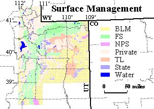
Attribute_Label: Surf
-
Attribute_Definition:
land ownership, surface management status
BLM ---- Bureau of Land Management
DOD ---- Department of Defense
FS ---- Forest Service
FSRA ---- Forest Service Recreation Area
FSWA ---- Forest Service Wilderness Area
FWS ---- Fish and Wildlife Service
NPS ---- National Park Service
PRIVATE ---- Private
SDOW ---- State Dept. of Wildlife
SP ---- State Park
STATE ---- State
TL ---- Tribal Land
WATER ---- Water
-
Attribute_Definition_Source: User Defined
-
Attribute_Domain_Values:
-
Unrepresentable_Domain: Character field
-
Attribute:
-
Attribute_Label: Statemins
-
Attribute_Definition:
State mineral ownership, subsurface ownership
ALL ---- Utah Trust Lands maintains full subsurface mineral Rights.
SOME ---- Utah Trust Lands maintains partial subsurface mineral rights.
Many of the polygons have no value in STATEMINS. In those areas the
State of Utah maintains none of the subsurface mineral rights.
-
Attribute_Definition_Source: User Defined
-
Attribute_Domain_Values:
-
Unrepresentable_Domain: Character field
-
Attribute:
-
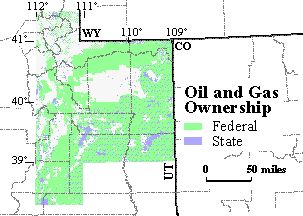
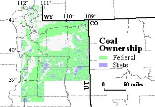
Attribute_Label: Fedmins
-
Attribute_Definition:
Federal mineral ownership, subsurface ownership
COAL+ ---- Federal government maintains mineral rights for coal and
other minerals. Where Statemins = SOME, the Federal government maintains
some mineral rights for coal and other minerals. Mineral resources
are frequently divided between state and Federal based on a royalty stream
or a specific tonnage, thereby allowing both entities to claim some ownership
of the resource.
NONE ---- Federal government maintains mineral rights for none of the
minerals.
OG+ ---- Federal government maintains mineral rights for oil and gas
and other minerals. Where Statemins = SOME, the Federal government
maintains some mineral rights for oil and gas and other minerals.
Mineral resources are frequently divided between state and Federal based
on a royalty stream or a specific tonnage, thereby allowing both entities
to claim some ownership of the resource.
OGC+ ---- Federal government maintains mineral rights for oil, gas,
coal and other minerals. Where Statemins = SOME, the Federal government
maintains some mineral rights for oil, gas, coal and other minerals.
Mineral resources are frequently divided between state and Federal based
on a royalty stream or a specific tonnage, thereby allowing both entities
to claim some ownership of the resource.
Many of the polygons have no value in FEDMINS. In those areas the Federal
government subsurface mineral rights are unknown or the Federal government
holds the rights for minerals other than those considered for this study.
-
Attribute_Definition_Source: User Defined
-
Attribute_Domain_Values:
-
Unrepresentable_Domain: Character field
-
Distribution_Information:
-
Distributor:
-
Contact_Information:
-
Contact_Organization_Primary:
-
Contact_Organization: U.S. Geological Survey
-
Contact_Address:
-
Address_Type: mailing and physical address
-
Address: P.O. Box 25046
-
City: Denver
-
State_or_Province: CO
-
Postal_Code: 80225-0046
-
Country: USA
-
Contact_Voice_Telephone: (303) 236-7773
-
Contact_Facsimile_Telephone: (303) 236-0459
-
Resource_Description: Arc/Info export file and shapefile
-
Distribution_Liability:
-
This data is not a legal document and is not intended to be used as such.
Any use of trade, product, or company names in this publication is for
descriptive purposes only and does not imply endorsement by the U.S. Government.
Although these data have been processed successfully on a computer system
at the U.S. Geological Survey, no warranty expressed or implied is made
by the USGS regarding the utility of the data on any other system, nor
shall the act of distribution constitute any such warranty.
-
Metadata_Reference_Information:
-
Metadata_Date: 19990722
-
Metadata_Contact:
-
Contact_Information:
-
Contact_Person_Primary:
-
Contact_Person: Laura R.H. Biewick
-
Contact_Organization: U.S. Geological Survey
-
Contact_Position: geologist
-
Contact_Address:
-
Address_Type: mailing and physical address
-
Address: P.O. Box 25046, MS 939
-
City: Denver
-
State_or_Province: CO
-
Postal_Code: 80225-0046
-
Country: USA
-
Contact_Voice_Telephone: (303) 236-7773
-
Contact_Facsimile_Telephone: (303) 236-0459
-
Contact_Electronic_Mail_Address: lbiewick@usgs.gov
-
Metadata_Standard_Name: FGDC Content Standards for Digital Geospatial
Metadata
-
Metadata_Standard_Version: FGDC-STD-001-1998
Generated by mp
version 2.4.8 on Mon Aug 09 13:56:03 1999