 |
|
|
||||
| MD-DE-DC Water Science Center |
U.S. GEOLOGICAL SURVEY
Open-File Report 99-87
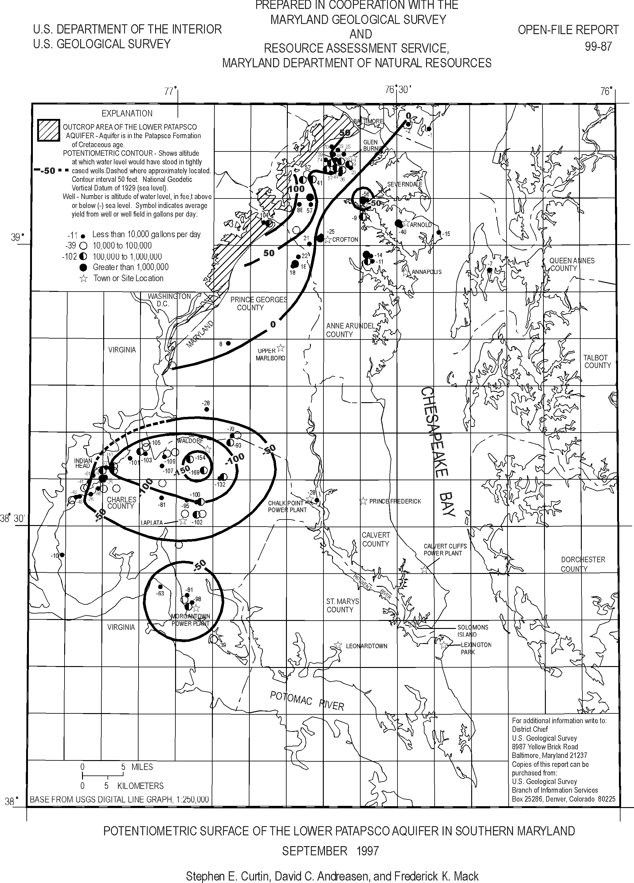
This report presents a map showing the potentiometric surface of the Lower Patapsco aquifer in the Patapsco Formation of Cretaceous age in Southern Maryland during September 1997. T he map was prepared from water-level measurements in 62 wells. The potentiometric surface was 88 feet above sea level near the northwestern boundary and outcrop area of the aquifer in a topographically high area of Anne Arundel County and 104 feet above sea level in a similar setting in Prince Georges County. From these high areas, the potentiometric surface declined towards large well fields at Crofton, Severndale, Arnold, and Annapolis. The ground-water levels reached 25 feet below sea level at Crofton, 56 feet below sea level at Severndale, 40 feet below sea level at Arnold, and 14 feet below sea level near Annapolis. The potentiometric surface also declined from LaPlata, Indian Head, and other surrounding areas toward a cone of depression at Waldorf. The ground-water levels were more than 100 feet below sea level at LaPlata, 110 feet below sea level at Indian Head, and 169 feet below sea level at Waldorf. A cone of depression is also present at the Morgantown power plant with a water level of 98 feet below sea level.
This report is available as a GIF file (Large Print Size) and in Portable Document Format (PDF)(8½ x 11 printed size).
View the OFR 99-87 report in GIF (190 KB)
View the OFR 99-87 report in PDF (132 KB)
This report is available online in Portable Document Format (PDF). If you do not have the Adobe Acrobat PDF Reader, it is available for free download from Adobe Systems Incorporated.
Document Accessibility: Adobe Systems Incorporated has information about PDFs and the visually impaired. This information provides tools to help make PDF files accessible. These tools and the accessible reader may be obtained free from Adobe at Adobe Access.
For more information about USGS activities in Maryland, Delaware and the District of Columbia contact:
Director
MD-DE-DC Water Science Center
U.S. Geological Survey
8987 Yellow Brick Road
Baltimore, MD 21237
Telephone: (410) 238-4200
Fax: (410) 238-4210
or access the USGS Water Resources of Maryland, Delaware, and District of Columbia home page at: http://md.water.usgs.gov/.
| AccessibilityFOIAPrivacyPolicies and Notices | |
 |
|