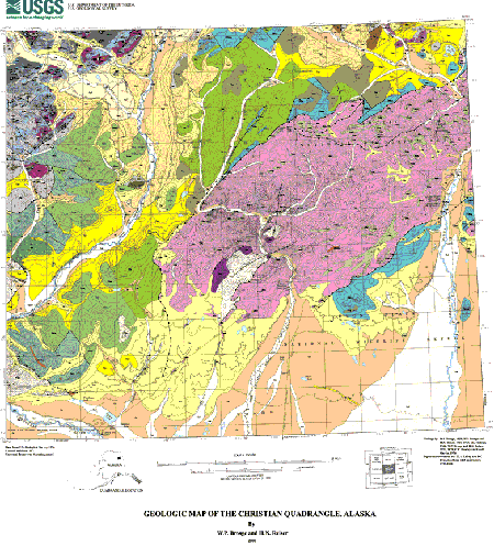
 Geologic Setting Geologic Setting
Most of the Christian quadrangle is in the Porcupine Plateau; the northwestern part is
in the southern Brooks Range, and the southern quarter is in the Yukon Flats. Outcrops of
bedrock are poor or lacking, except in the Brooks Range. Although large valley glaciers have
moved through the Porcupine Plateau, along the East Fork Chandalar and Vanticlese Creek,
most of the upland areas in the Porcupine Plateau have not been eroded by ice. Consequently
the rocks are deeply weathered and many outcrops in the low hills east of the East Fork are
only soil and rubble. The southern quarter of the quadrangle in the Yukon Flats is covered
with unconsolidated glacial and alluvial deposits.
The Christian quadrangle is at the east end of the southern Brooks Range schist belt.
Here three geologic terranes that originate well south of the Brooks Range intersect the
subterranes of the southern Brooks Range along northward-directed thrust faults and
northeast-striking strike slip faults. The displaced terranes from the south have been mapped
by Jones and others (1987), as the schist of the Ruby terrane, the mafic rocks and phyllite of
the Tozitna terrane, and the graywacke of the Venetie terrane. The typical rocks of the
southern Brooks Range Arctic Alaska terrane at this intersection are the carbonate and
clastic rocks of the Hammond subterrane, and the schist of the Coldfoot subterrane. The
Coldfoot schist ends at a probable strike-slip fault about 10 miles west of the Christian
quadrangle. At that place the mafic rocks and phyllites of the Angayucham terrane that
form the south flank of most of the Brooks Range veer sharply northeastward across the
Coldfoot subterrane schist and terminate it. A small fragment of the Endicott
Mountains subterrane of the Arctic Alaska terrane also lies within the Christian quadrangle,
but the main body of this subterrane lies north of the quadrangle.
|
First posted November 24, 2000
Digital Database files
Metadata and Readme Files
Part or all of this report is presented in Portable Document Format (PDF). For best results viewing and printing PDF documents, it is recommended that you download the documents to your computer and open them with Adobe Reader. PDF documents opened from your browser may not display or print as intended. Download the latest version of Adobe Reader, free of charge.
|

