 Introduction Introduction
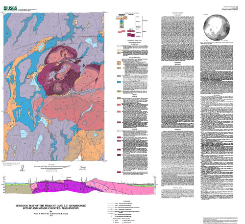
The Wildcat Lake quadrangle lies in the forearc of the Cascadia subduction zone, about 20-km east of the Cascadia accretionary complex exposed in the Olympic Mountains (Tabor and Cady, 1978),and about 100-km west of the axis of the Cascades volcanic arc. The quadrangle lies near the middle of the Puget Lowland, which typically has elevations less than 600 feet (183 m), but on Gold Mountain, in the center of the quadrangle, the elevation rises to 1761 feet (537 m). This anomalously high topography also provides a glimpse of the deeper crust beneath the Lowland. Exposed on Green and Gold Mountains are rocks related to the Coast Range basalt terrane. This terrane consists of Eocene submarine and subaerial tholeiitic basalt of the Crescent Formation, which probably accreted to the continental margin in Eocene time (Snavely and others, 1968). The Coast Range basalt terrane may have originated as an oceanic plateau or by oblique marginal rifting (Babcock and others, 1992), but its subsequent emplacement history is complex (Wells and others, 1984). In southern Oregon, onlapping strata constrain the suturing to have occured by 50 Ma; but on southern Vancouver Island where the terrane-bounding Leech River fault is exposed, Brandon and Vance (1992) concluded suturing to North America occurred in the broad interval between 42 and 24 Ma. After emplacement of the Coast Range basalt terrane, the Cascadia accretionary complex,exposed in the Olympic Mountains west of the quadrangle,developed by frontal accretion and underplating (e.g., Clowes and others, 1987). The Seattle basin, part of which lies to the north of Green Mountain, also began to develop in late Eocene time due to forced flexural subsidence along the Seattle fault zone (Johnson and others, 1994). Domal uplift of the accretionary complex beneath the Olympic Mountains occurred after approximately 18 million years ago (Brandon and others, 1998). Ice-sheet glaciation during Quaternary time reshaped the topography of the quadrangle, and approximately two-thirds of the map area is covered with Quaternary deposits related to the last glaciation. Geophysical studies and regional mapping indicate the Seattle fault lies north of Green Mountain. This fault produced a large earthquake about 1000 years ago and may pose a significant earthquake hazard (Bucknam and others, 1992; Atwater and Moore, 1992; Karlin and Abella,1992; Schuster and others, 1992; Jacoby and others, 1992). We found no evidence of Holocene faulting in the Wildcat Lake quadrangle.
Geologic mapping within and marginal to the quadrangle began with Willis (1898), who described glacial deposits in Puget Sound. Weaver (1937) correlated volcanic rocks in the quadrangle to the Eocene Metchosin Volcanics on Vancouver Island. Sceva (1957), Garling and Moleenar (1965), and Deeter (1978) all focused on mapping and understanding the Quaternary stratigraphy of the Kitsap Peninsula, but they also examined bedrock in the quadrangle. Reeve (1979) was the first to examine the igneous rocks on Green and Gold Mountains in some detail, and Clark (1989) significantly improved Reeve's (1979) mapping. Clark's (1989) mapping was conducted soon after extensive logging on the mountains. A surficial geologic map of the Seattle 1:100,000-scale quadrangle, which includes the Wildcat Lake 1:24,000-scale quadrangle, was published by Yount and others (1993). Yount and Gower (1991) also published a bedrock geologic map of the Seattle quadrangle. Geologic mapping for this report was conducted by Haeussler in the spring and summer of 1998 and in the winter of 1999. We could not substantially improve upon the bedrock mapping of Clark (1989) and thus it is incorporated into this map. Well data in the southeastern corner of the map area also helped to constrain the surficial mapping (Geomatrix Consultants, 1997). In addition, 1995 vintage 1:12,000-scale aerial photographs were used in mapping Quaternary deposits. Geologic time scale is that of Berggeren and others (1995).
|
First posted November 24, 2000
Refer to the Readme and Metadata files for more information.
Part or all of this report is presented in Portable Document Format (PDF). For best results viewing and printing PDF documents, it is recommended that you download the documents to your computer and open them with Adobe Reader. PDF documents opened from your browser may not display or print as intended. Download the latest version of Adobe Reader, free of charge.
|

