
 Gulf
of Mexico Bathymetry Contours
Gulf
of Mexico Bathymetry Contours
Metadata:
-
Identification_Information:
-
Citation:
-
Citation_Information:
-
Originator: Valerie Paskevich(comp.)
-
Publication_Date: 19981007
-
Title: Gulf of Mexico Bathymetry Contours
-
Geospatial_Data_Presentation_Form: map
-
Other_Citation_Details:
-
Gulf of Mexico bathymetric contours, in meters, provided by the USGSi,
Branch of Atlantic Marine Geology's Framework group. These data were digitized
by Kim Klitgord in 1982.
-
Larger_Work_Citation:
-
Citation_Information:
-
Originator: U.S. Geological Survey, Office of Marine Geology
-
Publication_Date: Unknown
-
Publication_Time: Unknown
-
Title: Exclusive Economic Zone boundary
-
Geospatial_Data_Presentation_Form: map
-
Description:
-
Abstract:
-
This GIS overlay is a component of the U. S Geological Survey, Woods Hole
Field Center's, Gulf of Mexico ArcView GIS database. The Gulf of Mexico
GIS database is intended to organize and display USGS held data and provide
on-line (WWW) access to the data and/or metadata.
-
Purpose:
-
This ArcView GIS layer is intended as an illustrative overlay to the Gulf
of Mexico. It contains the bathymetric contour lines, in meters, (200,
1000, 2000 and 300) for the Gulf of Mexico area in a polyline format.
-
Time_Period_of_Content:
-
Time_Period_Information:
-
Single_Date/Time:
-
Calendar_Date: 19981201
-
Currentness_Reference: Publication Date
-
Status:
-
Progress: Complete
-
Maintenance_and_Update_Frequency: None planned
-
Spatial_Domain:
-
Bounding_Coordinates:
-
West_Bounding_Coordinate: -97.4162
-
East_Bounding_Coordinate: -79.5000
-
North_Bounding_Coordinate: 29.8168
-
South_Bounding_Coordinate: 22.5
-
Keywords:
-
Theme:
-
Theme_Keyword_Thesaurus: General
-
Theme_Keyword: U.S. Geological Survey
-
Theme_Keyword: Woods Hole Field Center
-
Theme_Keyword: Gulf of Mexico database
-
Theme_Keyword: polyline
-
Theme_Keyword: vectors
-
Theme_Keyword: ArcView
-
Theme_Keyword: shapefile
-
Theme_Keyword: bathymetry contours
-
Theme_Keyword: isobath
-
Theme_Keyword: depth
-
Theme_Keyword: contours
-
Theme_Keyword: meters
-
Place:
-
Place_Keyword_Thesaurus: Gulf of Mexico
-
Place_Keyword: United States
-
Place_Keyword: Mexico
-
Place_Keyword: Cuba
-
Access_Constraints: None
-
Use_Constraints:
-
These data are NOT suitable to be used for any navigational or legal purpose.
The contour line data are in most cases manually digitized from a variety
of published or unpublished maps. These data are accessible for making
illustrations only. There is NO ASSURANCE of their accuracy, completeness,
or precision.
-
Point_of_Contact:
-
Contact_Information:
-
Contact_Organization_Primary:
-
Contact_Organization: U. S. Geological Survey
-
Contact_Person: Valerie Paskevich
-
Contact_Position: Computer Specialist
-
Contact_Address:
-
Address_Type: mailing and physical address
-
Address: 384 Woods Hole Road
-
City: Woods Hole
-
State_or_Province: MA
-
Postal_Code: 02543-1598
-
Country: USA
-
Contact_Voice_Telephone: (508) 548-8700 x2281
-
Contact_Facsimile_Telephone: (508) 457-2310
-
Contact_Electronic_Mail_Address: vpaskevich@usgs.gov
-
Hours_of_Service: M-Thu 6:30am-3:30pm; Fri 6:30am-10:30am
-
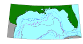
Browse_Graphic:
-
Browse_Graphic_File_Name: bathyc
-
Browse_Graphic_File_Description: GIF
-
Browse_Graphic_File_Type:
-
200m, 1000m, 2000m and 3000m contours of the Gulf of Mexico region
-
Data_Set_Credit: Kim Klitgord did the digitizing of these contours
in 1982.
-
Native_Data_Set_Environment: ESRI Shapefile format
-
Data_Quality_Information:
-
Attribute_Accuracy:
-
Attribute_Accuracy_Report: excellent
-
Quantitative_Attribute_Accuracy_Assessment:
-
Attribute_Accuracy_Value: 100
-
Attribute_Accuracy_Explanation: depth contour values are highly
accurate
-
Logical_Consistency_Report: .
-
Completeness_Report: .
-
Positional_Accuracy:
-
Horizontal_Positional_Accuracy:
-
Horizontal_Positional_Accuracy_Report: unknown
-
Quantitative_Horizontal_Positional_Accuracy_Assessment:
-
Horizontal_Positional_Accuracy_Value: 50
-
Horizontal_Positional_Accuracy_Explanation: resolution
-
Vertical_Positional_Accuracy:
-
Vertical_Positional_Accuracy_Report: unknown
-
Quantitative_Vertical_Positional_Accuracy_Assessment:
-
Vertical_Positional_Accuracy_Value: 50
-
Vertical_Positional_Accuracy_Explanation: resolution
-
Lineage:
-
Source_Information:
-
Source_Citation:
-
Citation_Information:
-
Originator: F.S. Sorensen,(comp.)
-
Originator: L.W. Snodgrass(comp.)
-
Originator: J.H. Rebman(comp.)
-
Originator: R.R. Murchison(comp.)
-
Originator: C.R. Jones(comp.)
-
Originator: Ray G. Martin(comp.)
-
Publication_Date: 19751230
-
Publication_Time: Unknown
-
Title: Bathymetric Map of Gulf of Mexico Region
-
Geospatial_Data_Presentation_Form: map
-
Series_Information:
-
Series_Name: U.S. Geological Survey Open-File Report
-
Issue_Identification: 75-140
-
Publication_Information:
-
Publication_Place: U.S. Geological Survey, Reston, VA
-
Publisher: U.S. Geological Survey
-
Source_Scale_Denominator: 2500000
-
Type_of_Source_Media: paper
-
Source_Time_Period_of_Content:
-
Time_Period_Information:
-
Single_Date/Time:
-
Calendar_Date: 19750131
-
Source_Currentness_Reference: Publication Date
-
Source_Citation_Abbreviation: OFR75-140
-
Source_Contribution:
-
Kim Klitgord did the digitizing of the map. The ASCII data set was later
converted to the MAPGEN coast format.
-
Source_Information:
-
Source_Citation:
-
Citation_Information:
-
Originator: J.E. Case(comp.)
-
Originator: T.L. Holcombe(comp.)
-
Publication_Date: 19801230
-
Publication_Time: Unknown
-
Title: Geologic-Tectonic Map of the Caribbean Region
-
Edition: USGS Miscellaneous Investigations Map
-
Geospatial_Data_Presentation_Form: map
-
Publication_Information:
-
Publication_Place: U.S. Geological Survey, Reston, VA
-
Publisher: U.S. Geological Survey
-
Source_Scale_Denominator: 2500000
-
Type_of_Source_Media: paper
-
Source_Time_Period_of_Content:
-
Time_Period_Information:
-
Single_Date/Time:
-
Calendar_Date: 19801230
-
Source_Currentness_Reference: Publication Date
-
Source_Citation_Abbreviation: caribmap
-
Source_Contribution:
-
Kim Klitgord did the digitizing of the map. The ASCII data set was later
converted to the MAPGEN coast format.
-
Process_Step:
-
Process_Description:
-
The digitized Gulf of Mexico bathymetry contour vector information has
been stored in a format for use with the U.S. Geological Survey's MAPGEN
program. The vector latitude/longitude coordinates were extracted from
from the MAPGEN file with the area coordinates of -99.5, 31.1 and -79.5,
22.5 using program getcoast.
-
Source_Used_Citation_Abbreviation: MAPGEN coast files
-
Process_Date: 19981201
-
Source_Produced_Citation_Abbreviation: bathy.txt
-
Process_Contact:
-
Contact_Information:
-
Contact_Organization_Primary:
-
Contact_Organization: U. S. Geological Survey
-
Contact_Person: Valerie Paskevich
-
Contact_Position: Computer Specialist
-
Contact_Address:
-
Address_Type: mailing and physical address
-
Address: 384 Woods Hole Road
-
City: Woods Hole
-
State_or_Province: MA
-
Postal_Code: 02543-1598
-
Country: USA
-
Contact_Voice_Telephone: (508) 548-8700 x2281
-
Contact_Facsimile_Telephone: (508) 457-2310
-
Contact_Electronic_Mail_Address: vpaskevich@usgs.gov
-
Process_Step:
-
Process_Description:
-
The ASCII vector file generated from the MAPGEN coast files was imported
to PCI Remote Sensing Software's Imageworks program. The vector line was
checked for digitizing errors using PCI's Imageworks program. Some editting
was done to delete spurious nodes and correct for overshoots and undershoots
in the line segments. The modified segment was saved and exported in the
ARC export format as bathyc.e00 with the nodes recorded as latitude/longitude
as signed decimal degrees.
-
Source_Used_Citation_Abbreviation: bathyc.txt
-
Process_Date: 19981006
-
Source_Produced_Citation_Abbreviation: eez.e00
-
Process_Contact:
-
Contact_Information:
-
Contact_Person_Primary:
-
Contact_Person: Valerie Paskevich
-
Contact_Organization: U. S. Geological Survey
-
Contact_Position: Computer Specialist
-
Contact_Address:
-
Address_Type: mailing and physical address
-
Address: 384 Woods Hole Road
-
City: Woods Hole
-
State_or_Province: MA
-
Postal_Code: 02543
-
Country: USA
-
Contact_Voice_Telephone: (508) 548-8700 x2281
-
Contact_Facsimile_Telephone: (508) 457-2310
-
Contact_Electronic_Mail_Address: vpaskevich@usgs.gov
-
Process_Step:
-
Process_Description:
-
The ARC export file, bathyc.e00, was imported to ARC as coverage bathyc.
The arc information was verified. No problems were identified.
-
Source_Used_Citation_Abbreviation: bathyc.e00
-
Process_Date: 19981201
-
Source_Produced_Citation_Abbreviation: bathyc.aat
-
Process_Contact:
-
Contact_Information:
-
Contact_Organization_Primary:
-
Contact_Organization: U. S. Geological Survey
-
Contact_Person: Valerie Paskevich
-
Contact_Position: Computer Specialist
-
Contact_Address:
-
Address_Type: mailing and physical address
-
Address: 384 Woods Hole Road
-
City: Woods Hole
-
State_or_Province: MA
-
Postal_Code: 02543-1598
-
Country: USA
-
Contact_Voice_Telephone: (508) 548-8700 x2281
-
Contact_Facsimile_Telephone: (508) 457-2310
-
Contact_Electronic_Mail_Address: vpaskevich@usgs.gov
-
Process_Step:
-
Process_Description:
-
The ARC polygon coverage, bathyc.aat, was exported as an ArcView shapefile,
bathyc.
-
Source_Used_Citation_Abbreviation: bathyc.aat
-
Process_Date: 19981201
-
Source_Produced_Citation_Abbreviation: bathyc.dbf
-
Source_Produced_Citation_Abbreviation: bathyc.shp
-
Source_Produced_Citation_Abbreviation: bathyc.shx
-
Process_Contact:
-
Contact_Information:
-
Contact_Organization_Primary:
-
Contact_Organization: U. S. Geological Survey
-
Contact_Person: Valerie Paskevich
-
Contact_Position: Computer Specialist
-
Contact_Address:
-
Address_Type: mailing and physical address
-
Address: 384 Woods Hole Road
-
City: Woods Hole
-
State_or_Province: MA
-
Postal_Code: 02543
-
Country: USA
-
Contact_Voice_Telephone: (508) 548-8700 x2281
-
Contact_Facsimile_Telephone: (508) 457-2310
-
Contact_Electronic_Mail_Address: vpaskevich@usgs.gov
-
Process_Step:
-
Process_Description:
-
The ArcView shapefile, bathyc, was brought into ArcView for final viewing
and verification. No further editting or changes were needed to the shape
file.
-
Source_Used_Citation_Abbreviation: bathyc.dbf
-
Source_Used_Citation_Abbreviation: bathyc.shp
-
Source_Used_Citation_Abbreviation: bathyc.shx
-
Process_Date: 19981201
-
Source_Produced_Citation_Abbreviation: bathyc.dbf
-
Source_Produced_Citation_Abbreviation: bathyc.shp
-
Source_Produced_Citation_Abbreviation: bathyc.shx
-
Process_Contact:
-
Contact_Information:
-
Contact_Organization_Primary:
-
Contact_Organization: U. S. Geological Survey
-
Contact_Person: Valerie Paskevich
-
Contact_Position: Computer Specialist
-
Contact_Address:
-
Address_Type: mailing and physical address
-
Address: 384 Woods Hole Road
-
City: Woods Hole
-
State_or_Province: MA
-
Postal_Code: 02543-1598
-
Country: USA
-
Contact_Voice_Telephone: (508) 548-8700 x2281
-
Contact_Facsimile_Telephone: (508) 457-2310
-
Contact_Electronic_Mail_Address: vpaskevich@usgs.gov
-
Spatial_Data_Organization_Information:
-
Direct_Spatial_Reference_Method: Vector
-
Point_and_Vector_Object_Information:
-
SDTS_Terms_Description:
-
SDTS_Point_and_Vector_Object_Type: Complete chain
-
Point_and_Vector_Object_Count: 2
-
Spatial_Reference_Information:
-
Horizontal_Coordinate_System_Definition:
-
Geographic:
-
Latitude_Resolution: .005
-
Longitude_Resolution: .005
-
Geographic_Coordinate_Units: Decimal degrees
-
Geodetic_Model:
-
Horizontal_Datum_Name: North American Datum of 1927
-
Ellipsoid_Name: Clarke 1866
-
Semi-major_Axis: 6378206.4
-
Denominator_of_Flattening_Ratio: 294.98
-
Entity_and_Attribute_Information:
-
Detailed_Description:
-
Entity_Type:
-
Entity_Type_Label: bathyc.dbf
-
Entity_Type_Definition: Shapefile Attribute Table
-
Entity_Type_Definition_Source: None
-
Attribute:
-
Attribute_Label: Fnode_
-
Attribute_Definition: From-node identifier of linear feature
-
Attribute_Definition_Source: Software computed
-
Attribute_Domain_Values:
-
Range_Domain:
-
Range_Domain_Minimum: 0
-
Range_Domain_Maximum: 7
-
Attribute:
-
Attribute_Label: Tnode_
-
Attribute_Definition: To-node identifier of linear feature
-
Attribute_Definition_Source: Software computed
-
Attribute_Domain_Values:
-
Range_Domain:
-
Range_Domain_Minimum: 0
-
Range_Domain_Maximum: 9
-
Attribute:
-
Attribute_Label: Lpoly_
-
Attribute_Definition: Internal number of polygon to left of arc
-
Attribute_Definition_Source: Software computed
-
Attribute_Domain_Values:
-
Range_Domain:
-
Range_Domain_Minimum: 0
-
Range_Domain_Maximum: 0
-
Attribute:
-
Attribute_Label: Rpoly_
-
Attribute_Definition: Internal number of polygon to right of arc
-
Attribute_Definition_Source: Software computed
-
Attribute_Domain_Values:
-
Range_Domain:
-
Range_Domain_Minimum: 0
-
Range_Domain_Maximum: 0
-
Attribute:
-
Attribute_Label: Length
-
Attribute_Definition: Length of line
-
Attribute_Definition_Source: Software computed
-
Attribute_Domain_Values:
-
Range_Domain:
-
Range_Domain_Minimum: 0.117
-
Range_Domain_Maximum: 23.407
-
Attribute:
-
Attribute_Label: Bathyc_
-
Attribute_Definition:
-
Value from ARC assigned BATHYC# from bathyc.dbf table. Generally has no
meaning in ArcView shapefile.
-
Attribute_Definition_Source: User Defined
-
Attribute_Domain_Values:
-
Range_Domain:
-
Range_Domain_Minimum: 1
-
Range_Domain_Maximum: 23
-
Attribute:
-
Attribute_Label: Bathyc_id
-
Attribute_Definition:
-
Value from ARC assigned BATHYC-ID from bathyc.dbf table. Generally has
no meaning in ArcView shapefile.
-
Attribute_Definition_Source: User Defined
-
Attribute_Domain_Values:
-
Range_Domain:
-
Range_Domain_Minimum: 1
-
Range_Domain_Maximum: 18
-
Attribute:
-
Attribute_Label: Depth
-
Attribute_Definition: Depth contour value, in meters
-
Attribute_Definition_Source: User Defined
-
Attribute_Domain_Values:
-
Range_Domain:
-
Range_Domain_Minimum: 200
-
Range_Domain_Maximum: 3000
-
Attribute_Units_of_Measure: meters
-
Attribute_Measurement_Resolution: 50
-
Beginning_Date_of_Attribute_Values: 19981202
-
Attribute_Measurement_Frequency: Irregular
-
Distribution_Information:
-
Distributor:
-
Contact_Information:
-
Contact_Organization_Primary:
-
Contact_Organization: U. S. Geological Survey
-
Contact_Person: Valerie Paskevich
-
Contact_Position: Computer Specialist
-
Contact_Address:
-
Address_Type: mailing and physical address
-
Address: 384 Woods Hole Road
-
City: Woods Hole
-
State_or_Province: MA
-
Postal_Code: 02543-1598
-
Country: USA
-
Contact_Voice_Telephone: (508) 548-8700 x2281
-
Contact_Facsimile_Telephone: (508) 457-2310
-
Contact_Electronic_Mail_Address: vpaskevich@usgs.gov
-
Resource_Description: Gulf of Mexico GIS database: bathyc.shp
-
Distribution_Liability:
-
Although this derived data set and it's lineage dataset have been used
by the USGS, no warranty, expressed or implied, is made by the USGS as
to the accuracy of the data and/or related materials. The act of distribution
shall not constitute any such warranty, and no responsibility is assumed
by the USGS in the use of these data or related materials. These data are
NOT suitable to be used for any navigational or legal purpose. The contour
line data are in most cases manually digitized from a variety of published
or unpublished maps. There is NO ASSURANCE of their accuracy, completeness,
or precision.
-
Standard_Order_Process:
-
Digital_Form:
-
Digital_Transfer_Information:
-
Format_Name: ARCE
-
Format_Information_Content:
-
bathyc.dbf
-
bathyc.shp
-
bathyc.shx
-
File_Decompression_Technique: No compression applied
-
Transfer_Size: 72Kb
-
Digital_Transfer_Option:
-
Offline_Option:
-
Offline_Media: CD-ROM
-
Recording_Capacity:
-
Recording_Density: 650
-
Recording_Density_Units: Mbytes
-
Recording_Format: ISO 9600
-
Compatibility_Information:
-
The user must have a system with a CD-ROM capable of reading an ISO-9660
standard CD-ROM disk. To browse the information contained on this disk,
the user must also have a current version of WWW browser.
-
Fees: none
-
Standard_Order_Process:
-
Digital_Form:
-
Digital_Transfer_Information:
-
Format_Name: ARCE
-
Format_Information_Content:
-
The three ArcView shapefiles (bathyc.dbf, bathyc.shp, bathyc.shx) comprising
the bathymetric contours (bathyc) coverage.
-
File_Decompression_Technique: zip
-
Transfer_Size: 30Kb
-
Digital_Transfer_Option:
-
Offline_Option:
-
Offline_Media: CD-ROM
-
Recording_Capacity:
-
Recording_Density: 650
-
Recording_Density_Units: Mbytes
-
Recording_Format: ISO 9600
-
Compatibility_Information:
-
The user must have a system with a CD-ROM capable of reading an ISO-9660
standard CD-ROM disk. To browse the information contained on this disk,
the user must also have a current version of WWW browser available.
-
Fees: none
-
Custom_Order_Process: not available
-
Technical_Prerequisites:
-
There are no technical requirements for downloading the data. However to
use the ArcView shape files the user must have an ESRI software product
or some other GIS program that allows importing of ArcView shapefiles.
-
Metadata_Reference_Information:
-
Metadata_Date: 19990819
-
Metadata_Contact:
-
Contact_Information:
-
Contact_Organization_Primary:
-
Contact_Organization: U. S. Geological Survey
-
Contact_Person: Valerie Paskevich
-
Contact_Position: Computer Specialist
-
Contact_Address:
-
Address_Type: mailing and physical address
-
Address: 384 Woods Hole Rd.
-
City: Woods Hole
-
State_or_Province: MA
-
Postal_Code: 02543-1598
-
Country: USA
-
Contact_Voice_Telephone: (508) 548-8700 x2281
-
Contact_Facsimile_Telephone: (508) 457-2310
-
Contact_Electronic_Mail_Address: vpaskevich@usgs.gov
-
Metadata_Standard_Name: FGDC Content Standards for Digital Geospatial
Metadata
-
Metadata_Standard_Version: CSDGM version 2
-
Metadata_Time_Convention: Local time
-
Metadata_Access_Constraints: None
-
Metadata_Use_Constraints:
-
Although this derived data set and it's lineage dataset have been used
by the USGS, no warranty, expressed or implied, is made by the USGS as
to the accuracy of the data and/or related materials. The act of distribution
shall not constitute any such warranty, and no responsibility is assumed
by the USGS in the use of these data or related materials.
Generated by mp
on Thu Aug 19 11:21:47 1999