
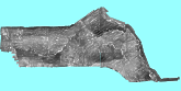
 GLORIA
sidescan sonar mosaic
GLORIA
sidescan sonar mosaic
Metadata:
-
Identification_Information:
-
Citation:
-
Citation_Information:
-
Originator: Valerie Paskevich(comp.)
-
Publication_Date: 19990325
-
Publication_Time: Unknown
-
Title: GLORIA sidescan sonar mosaic
-
Geospatial_Data_Presentation_Form: remote-sensing image
-
Publication_Information:
-
Publication_Place: U.S. Geological Survey, Woods Hole, MA
-
Publisher: USGS Coastal and Marine Geology Team
-
Description:
-
Abstract:
-
This GIS overlay is a component of the U. S Geological Survey, Woods Hole
Field Center's, Gulf of Mexico ArcView GIS database. The Gulf of Mexico
GIS database is intended to organize and display USGS held data and provide
on-line (WWW) access to the data and/or metadata.
-
Purpose:
-
This ArcView GIS layer is a 250m version of the composite Gulf of Mexico
GLORIA sidescan sonar mosaic.
-
Supplemental_Information:
-
This version of the image has an "ice blue" background surrounding the
mosaic area. This image is used with the ArcView project views.
-
Time_Period_of_Content:
-
Time_Period_Information:
-
Multiple_Dates/Times:
-
Calendar_Date: 19820202
-
Calendar_Date: 19820224
-
Calendar_Date: 19850807
-
Calendar_Date: 19850903
-
Calendar_Date: 19851002
-
Calendar_Date: 19851022
-
Currentness_Reference: data collection
-
Status:
-
Progress: Complete
-
Maintenance_and_Update_Frequency: None planned
-
Spatial_Domain:
-
Bounding_Coordinates:
-
West_Bounding_Coordinate: -96
-
East_Bounding_Coordinate: -82
-
North_Bounding_Coordinate: 29.5
-
South_Bounding_Coordinate: 23
-
Keywords:
-
Theme:
-
Theme_Keyword_Thesaurus: General
-
Theme_Keyword: U.S. Geological Survey
-
Theme_Keyword: Woods Hole Field Center
-
Theme_Keyword: Gulf of Mexico database
-
Theme_Keyword: Exclusive Economic Zone
-
Theme_Keyword: EEZ
-
Theme_Keyword: GLORIA
-
Theme_Keyword: sidescan sonar
-
Theme_Keyword: sidescan sonar mosaic
-
Theme_Keyword: composite mosaic
-
Theme_Keyword: TIFF
-
Theme_Keyword: Geologic Long-Range Inclined Asdic
-
Theme_Keyword: Geotiff
-
Place:
-
Place_Keyword_Thesaurus: General
-
Place_Keyword: Gulf of Mexico
-
Place_Keyword: U.S. EEZ
-
Place_Keyword: U.S. Exclusive Economic Zone
-
Access_Constraints: None
-
Use_Constraints:
-
The U.S. Geological Survey must be referenced as the originator of the
dataset in any future products or research derived from these data.
-
Point_of_Contact:
-
Contact_Information:
-
Contact_Organization_Primary:
-
Contact_Organization: U. S. Geological Survey
-
Contact_Person: Valerie Paskevich
-
Contact_Position: Computer Specialist
-
Contact_Address:
-
Address_Type: mailing and physical address
-
Address: 384 Woods Hole Road
-
City: Woods Hole
-
State_or_Province: MA
-
Postal_Code: 02543-1598
-
Country: USA
-
Contact_Voice_Telephone: (508) 548-8700 x2281
-
Contact_Facsimile_Telephone: (508) 457-2281
-
Contact_Electronic_Mail_Address: vpaskevich@usgs.gov
-
Browse_Graphic:
-
Browse_Graphic_File_Name: glo250m
-
Browse_Graphic_File_Description: GIF
-
Browse_Graphic_File_Type:
-
250 m image of the GLORIA sidescan mosaic for the Gulf of Mexico with an
"ice blue" background
-
Native_Data_Set_Environment: GEOTIF
-
Data_Quality_Information:
-
Attribute_Accuracy:
-
Attribute_Accuracy_Report: no attributes associated with the image
-
Logical_Consistency_Report: okay
-
Completeness_Report: complete
-
Lineage:
-
Source_Information:
-
Source_Citation:
-
Citation_Information:
-
Originator: Valerie Paskevich(comp.)
-
Publication_Date: 19961008
-
Publication_Time: 14300000
-
Title:
-
Digital Mosaics of the GLORIA Sidescan Sonar Data of the Gulf of Mexico
-
Edition: revised August 1997
-
Geospatial_Data_Presentation_Form: remote-sensing image
-
Series_Information:
-
Series_Name: U.S. Geological Survey Open-File Report
-
Issue_Identification: OFR96-657
-
Publication_Information:
-
Publication_Place: U.S. Geological Survey
-
Publisher: Coastal and Marine Geology Program, Woods Hole, MA
-
Online_Linkage: http://kai.er.usgs.gov/images/gloria/
-
Larger_Work_Citation:
-
Citation_Information:
-
Originator: various(comp.)
-
Publication_Date: Unknown
-
Publication_Time: Unknown
-
Title:
-
U. S. Exclusive Economic Zone, Gulf of Mexico and eastern Caribbean areas
-
Geospatial_Data_Presentation_Form: atlas
-
Series_Information:
-
Series_Name: U.S. Geological Survey Miscellaneous Investigations
-
Issue_Identification: I-1864-A
-
Publication_Information:
-
Publication_Place: U.S. Geological Survey, Reston, VA
-
Publisher: U.S. Geological Survey, Office of Marine Geology
-
Type_of_Source_Media: CD-ROM
-
Source_Time_Period_of_Content:
-
Time_Period_Information:
-
Range_of_Dates/Times:
-
Beginning_Date: 19880202
-
Ending_Date: 19880224
-
Source_Currentness_Reference: data collection
-
Source_Citation_Abbreviation: OFR96-657
-
Source_Contribution:
-
The 16 individual 50 m mosaics were combined to create the 250 m composite
Gulf of Mexico GLORIA mosaic.
-
Source_Information:
-
Source_Citation:
-
Citation_Information:
-
Originator: U.S. Geological Survey(comp.)
-
Originator: National Oceanic and Atmospheric Administration
-
Originator: National Aeronautics and Space Administration
-
Publication_Date: 19880323
-
Publication_Time: Unknown
-
Title: GLORIA Data: Gulf of Mexico
-
Geospatial_Data_Presentation_Form: remote-sensing image
-
Series_Information:
-
Series_Name: GLORIA Data: Gulf of Mexico
-
Issue_Identification: Gloria01
-
Publication_Information:
-
Publication_Place: U.S. Geological Survey, Reston, VA
-
Publisher: U.S. Geological Survey, Office of Energy and Marine Geology
-
Type_of_Source_Media: CD-ROM
-
Source_Time_Period_of_Content:
-
Time_Period_Information:
-
Range_of_Dates/Times:
-
Beginning_Date: 19880202
-
Ending_Date: 19880224
-
Source_Currentness_Reference: data collection
-
Source_Citation_Abbreviation: I-1864-A,B
-
Source_Contribution:
-
Raw imagery of GLORIA data may be retrieved from this CD-ROM. The user
must note the number of pixels (samples) and lines contained in the data
set to convert the raw imagery to a useable image format. The information
can be found in the 'lbl' file associated with the image file.
-
Process_Step:
-
Process_Description:
-
The 16 individual 50 m GLORIA digital sidescan sonar mosaics were re-sampled
to 250 m and combined to create an overview digital mosaic of the Gulf
of Mexico.
-
Source_Used_Citation_Abbreviation: OFR96-657
-
Source_Used_Citation_Abbreviation: mos01.tif-mos16.tif
-
Process_Date: 19980904
-
Source_Produced_Citation_Abbreviation: compos.pix
-
Process_Contact:
-
Contact_Information:
-
Contact_Organization_Primary:
-
Contact_Organization: U. S. Geological Survey
-
Contact_Person: Valerie Paskevich
-
Contact_Position: Computer Specialist
-
Contact_Address:
-
Address_Type: mailing and physical address
-
Address: 384 Woods Hole Road
-
City: Woods Hole
-
State_or_Province: MA
-
Postal_Code: 02543-1598
-
Country: USA
-
Contact_Voice_Telephone: (508) 548-8700 x2281
-
Contact_Facsimile_Telephone: (508) 457-2310
-
Contact_Electronic_Mail_Address: vpaskevich@usgs.gov
-
Process_Step:
-
Process_Description:
-
The completed 250m Gulf of Mexico GLORIA mosaic was exported as a geotiff
image with an associated ARC "world" file.
-
Source_Used_Citation_Abbreviation: compos.pix
-
Process_Date: 19980904
-
Source_Produced_Citation_Abbreviation: glo250m.tif
-
Process_Contact:
-
Contact_Information:
-
Contact_Organization_Primary:
-
Contact_Organization: U. S. Geological Survey
-
Contact_Person: Valerie Paskevich
-
Contact_Position: Computer Specialist
-
Contact_Address:
-
Address_Type: mailing and physical address
-
Address: 384 Woods Hole Road
-
City: Woods Hole
-
State_or_Province: MA
-
Postal_Code: 02543-1598
-
Country: USA
-
Contact_Voice_Telephone: (508) 548-8700 x2281
-
Contact_Facsimile_Telephone: (508) 457-2310
-
Contact_Electronic_Mail_Address: vpaskevich@usgs.gov
-
Spatial_Data_Organization_Information:
-
Direct_Spatial_Reference_Method: Raster
-
Raster_Object_Information:
-
Raster_Object_Type: Pixel
-
Row_Count: 2848
-
Column_Count: 5635
-
Spatial_Reference_Information:
-
Horizontal_Coordinate_System_Definition:
-
Planar:
-
Map_Projection:
-
Map_Projection_Name: Albers Conical Equal Area
-
Albers_Conical_Equal_Area:
-
Standard_Parallel: 29.5
-
Standard_Parallel: 45.5
-
Longitude_of_Central_Meridian: -089.000000
-
Latitude_of_Projection_Origin: +00.000000
-
False_Easting: 0
-
False_Northing: 0
-
Planar_Coordinate_Information:
-
Planar_Coordinate_Encoding_Method: row and column
-
Coordinate_Representation:
-
Abscissa_Resolution: 250
-
Ordinate_Resolution: 250
-
Planar_Distance_Units: Meters
-
Geodetic_Model:
-
Horizontal_Datum_Name: North American Datum of 1927
-
Ellipsoid_Name: Clarke 1866
-
Semi-major_Axis: 6378206.4
-
Denominator_of_Flattening_Ratio: 294.98
-
Distribution_Information:
-
Distributor:
-
Contact_Information:
-
Contact_Organization_Primary:
-
Contact_Organization: U. S. Geological Survey
-
Contact_Person: Valerie Paskevich
-
Contact_Position: Computer Specialist
-
Contact_Address:
-
Address_Type: mailing and physical address
-
Address: 384 Woods Hole Road
-
City: Woods Hole
-
State_or_Province: MA
-
Postal_Code: 02543-1598
-
Country: USA
-
Contact_Voice_Telephone: (508) 548-8700 x2281
-
Contact_Facsimile_Telephone: (508) 457-2310
-
Contact_Electronic_Mail_Address: vpaskevich@usgs.gov
-
Resource_Description: glo250m.tif
-
Distribution_Liability:
-
Although this derived data set and it's lineage dataset have been used
by the USGS, no warranty, expressed or implied, is made by the USGS as
to the accuracy of the data and/or related materials. The act of distribution
shall not constitute any such warranty, and no responsibility is assumed
by the USGS in the use of these data or related materials.
-
Standard_Order_Process:
-
Digital_Form:
-
Digital_Transfer_Information:
-
Format_Name: TIFF
-
File_Decompression_Technique: No compression applied
-
Transfer_Size: 47040KB
-
Digital_Transfer_Option:
-
Offline_Option:
-
Offline_Media: CD-ROM
-
Recording_Capacity:
-
Recording_Density: 650
-
Recording_Density_Units: Mbytes
-
Recording_Format: ISO 9600
-
Compatibility_Information:
-
The user must have a system with a CD-ROM capable of reading an ISO-9660
standard CD-ROM disk. To browse the information contained on this disk,
the user must also have a current version of WWW browser available.
-
Fees: none
-
Technical_Prerequisites:
-
Access to the data and information contained on this CD-ROM was developed
using the HyperText Markup Language (HTML) utilized by the World Wide Web
(WWW) project. Development of the CD-ROM ocumentation and user interface
in HTML allows a user to access the information by using a variety of WWW
information browsers (i.e. NCSA Mosaic, Netscape, Microsoft Explorer) to
facilitate browsing and locating information and data. To access the information
contained on this disk with a WWW client browser, open the file 'intro.htm'
at the top level directory of this CD-ROM with your selected browser.
-
This CD-ROM should be readable by a variety of operating systems including
Windows 95/98/NT, Macintosh and UNIX.
-
An image viewer or image processing or GIS software package capable of
importing a GEOTIFF format file. If the georeferencing information cannot
be imported, the user may wish to download the georeferencing information
contained in a separate file, glo250m.txt and compos.txt in the data/imagery/aea/georep
directory.
-
Metadata_Reference_Information:
-
Metadata_Date: 19990818
-
Metadata_Contact:
-
Contact_Information:
-
Contact_Organization_Primary:
-
Contact_Organization: U. S. Geological Survey
-
Contact_Person: Valerie Paskevich
-
Contact_Position: Computer Specialist
-
Contact_Address:
-
Address_Type: mailing and physical address
-
Address: 384 Woods Hole Rd.
-
City: Woods Hole
-
State_or_Province: MA
-
Postal_Code: 02543-1598
-
Country: USA
-
Contact_Voice_Telephone: (508) 548-8700 x2281
-
Contact_Facsimile_Telephone: (508) 457-2310
-
Contact_Electronic_Mail_Address: vpaskevich@usgs.gov
-
Metadata_Standard_Name: FGDC Content Standards for Digital Geospatial
Metadata
-
Metadata_Standard_Version: CSDGM version 2
-
Metadata_Time_Convention: Local time
-
Metadata_Access_Constraints: None
-
Metadata_Use_Constraints: None
Generated by mp
on Thu Aug 19 11:22:20 1999