
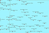
 Gulf
of Mexico features names
Gulf
of Mexico features names
Metadata:
-
Identification_Information:
-
Citation:
-
Citation_Information:
-
Originator: National Oceanic and Atomospheric Administration(comp.)
-
Publication_Date: Unknown
-
Publication_Time: Unknown
-
Title: Gulf of Mexico features names
-
Online_Linkage: http://www.ngdc.noaa.gov/mgg/ibcca/html/images.htm
-
Online_Linkage: http://www.ngdc.noaa.gov/mgg/ibcca/
-
Description:
-
Abstract:
-
This GIS overlay is a component of the U. S. Geological Survey, Woods Hole
Field Center's, Gulf of Mexico ArcView GIS database. The Gulf of Mexico
GIS database is intended to organize and display USGS held data and provide
on-line (WWW) access to the data and/or metadata.
-
Purpose:
-
This ArcView shapefile an additional GIS overlay. It contains the names
of various seafloor features (basins, slopes, knolls, ridges, etc.) for
the Gulf of Mexico.
-
Supplemental_Information:
-
This ArcView shapefile was created from a Microsoft Excel spread sheet
found at the National Oceanic and Atmospheric's National Geophysical Data
Center's website. The information contained in the spread sheet was editted
to include only those features that would pertain to the planned Gulf of
Mexico Internet Map Server for the USGS, Woods Hole Field center. Therefore,
this is not a complete listing as would be found from NOAA-NGDC.
-
Time_Period_of_Content:
-
Time_Period_Information:
-
Single_Date/Time:
-
Calendar_Date: 19990614
-
Currentness_Reference: Publication Date
-
Status:
-
Progress: Complete
-
Maintenance_and_Update_Frequency: Unknown
-
Spatial_Domain:
-
Bounding_Coordinates:
-
West_Bounding_Coordinate: -97.5
-
East_Bounding_Coordinate: -79.9167
-
North_Bounding_Coordinate: 31.00000
-
South_Bounding_Coordinate: 23.50000
-
Keywords:
-
Theme:
-
Theme_Keyword_Thesaurus: General
-
Theme_Keyword: U.S. Geological Survey
-
Theme_Keyword: Woods Hole Field Center
-
Theme_Keyword: Gulf of Mexico database
-
Theme_Keyword: feature names
-
Theme_Keyword: seafloor features
-
Theme_Keyword: ArcView
-
Theme_Keyword: shapefile
-
Place:
-
Place_Keyword_Thesaurus: General
-
Place_Keyword: Gulf of Mexico
-
Access_Constraints: None
-
Use_Constraints:
-
Although this derived data set and it's lineage dataset have been used
by the USGS, no warranty, expressed or implied, is made by the USGS as
to the accuracy of the data and/or related materials. The act of distribution
shall not constitute any such warranty, and no responsibility is assumed
by the USGS in the use of these data or related materials.
-
Point_of_Contact:
-
Contact_Information:
-
Contact_Organization_Primary:
-
Contact_Organization: U. S. Geological Survey
-
Contact_Person: Valerie Paskevich
-
Contact_Position: Computer Specialist
-
Contact_Address:
-
Address_Type: mailing and physical address
-
Address: 384 Woods Hole Road
-
City: Woods Hole
-
State_or_Province: MA
-
Postal_Code: 02543-1598
-
Country: USA
-
Contact_Voice_Telephone: (508) 548-8700 x2281
-
Contact_Facsimile_Telephone: (508) 457-2310
-
Contact_Electronic_Mail_Address: vpaskevich@usgs.gov
-
Hours_of_Service: M-Thu 6:30am-3:30pm; Fri 6:30am-10:30am
-
Browse_Graphic:
-
Browse_Graphic_File_Name: http://www.ngdc.noaa.gov/mgg/ibcca/html/images.htm
-
Browse_Graphic_File_Description: JPEG
-
Browse_Graphic_File_Type: Undersea Feature Name Image
-
Data_Set_Credit:
-
NOAA - National Geophysical Data Center (NGDC), Marine Geology & Geophysics
& World Data Center A for MGG
-
Native_Data_Set_Environment: ESRI Shapefile format
-
Data_Quality_Information:
-
Logical_Consistency_Report: .
-
Completeness_Report: .
-
Lineage:
-
Process_Step:
-
Process_Description:
-
The Microsoft Excel datafile was downloaded from the NOAA-NGDC site and
read into Excel. Records that did not contain a latitude/longitude coordinate
for a feature name was deleted from the spreadsheet. The text fields containing
the latitude and longitude coordinate of the seafloor feature were then
copied and added to the spreadsheet as the first two fields. These fields
were added so numeric latitude longitude fields recorded as signed decimal
degrees could be created later. The modified spreadsheet was saved as a
comma separated values text file.
-
Source_Used_Citation_Abbreviation: ib1234gz.xls
-
Process_Date: 19990614
-
Source_Produced_Citation_Abbreviation: gomnames.csv
-
Process_Contact:
-
Contact_Information:
-
Contact_Organization_Primary:
-
Contact_Organization: U. S. Geological Survey
-
Contact_Person: Valerie Paskevich
-
Contact_Position: Computer Specialist
-
Contact_Address:
-
Address_Type: mailing and physical address
-
Address: 384 Woods Hole Rd.
-
City: Woods Hole
-
State_or_Province: MA
-
Postal_Code: 02543-1598
-
Country: USA
-
Contact_Voice_Telephone: (508) 548-8700 x2281
-
Contact_Facsimile_Telephone: (508) 457-2310
-
Contact_Electronic_Mail_Address: vpaskevich@usgs.gov
-
Process_Step:
-
Process_Description:
-
The comma separated values file was processed on a UNIX operating system
to convert the first two text fields that contained the feature coordinates
to numeric, signed decimal degree fields.
-
Source_Used_Citation_Abbreviation: gomnames.csv
-
Process_Date: 19990614
-
Source_Produced_Citation_Abbreviation: gomnames.txt
-
Process_Contact:
-
Contact_Information:
-
Contact_Organization_Primary:
-
Contact_Organization: U. S. Geological Survey
-
Contact_Person: Valerie Paskevich
-
Contact_Position: Computer Specialist
-
Contact_Address:
-
Address_Type: mailing and physical address
-
Address: 384 Woods Hole Rd.
-
City: Woods Hole
-
State_or_Province: MA
-
Postal_Code: 02543-1598
-
Country: USA
-
Contact_Voice_Telephone: (508) 548-8700 x2281
-
Contact_Facsimile_Telephone: (508) 457-2310
-
Contact_Electronic_Mail_Address: vpaskevich@usgs.gov
-
Process_Step:
-
Process_Description:
-
The text file with geographic coordinates was read into ArcView as a table.
Features locations that did not fall within the bounds of the Gulf of Mexico
IMS were eliminated, and the remaining table information was converted
to an ArcView shapefile.
-
Source_Used_Citation_Abbreviation: gomnames.txt
-
Process_Date: 19990614
-
Source_Produced_Citation_Abbreviation: gomnames.shp
-
Process_Contact:
-
Contact_Information:
-
Contact_Organization_Primary:
-
Contact_Organization: U. S. Geological Survey
-
Contact_Person: Valerie Paskevich
-
Contact_Position: Computer Specialist
-
Contact_Address:
-
Address_Type: mailing and physical address
-
Address: 384 Woods Hole Rd.
-
City: Woods Hole
-
State_or_Province: MA
-
Postal_Code: 02543-1598
-
Country: USA
-
Contact_Voice_Telephone: (508) 548-8700 x2281
-
Contact_Facsimile_Telephone: (508) 457-2310
-
Contact_Electronic_Mail_Address: vpaskevich@usgs.gov
-
Spatial_Data_Organization_Information:
-
Direct_Spatial_Reference_Method: Point
-
Point_and_Vector_Object_Information:
-
SDTS_Terms_Description:
-
SDTS_Point_and_Vector_Object_Type: Point
-
Point_and_Vector_Object_Count: 254
-
Entity_and_Attribute_Information:
-
Detailed_Description:
-
Entity_Type:
-
Entity_Type_Label: gomnames.dbf
-
Entity_Type_Definition: Shapefile Attribute Table
-
Entity_Type_Definition_Source: None
-
Attribute:
-
Attribute_Label: Lon
-
Attribute_Definition:
-
Longitude coordinate of feature recorded in decimal degrees.
-
Attribute_Definition_Source: User Defined
-
Attribute_Domain_Values:
-
Range_Domain:
-
Range_Domain_Minimum: -97.5000
-
Range_Domain_Maximum: -79.91667
-
Attribute:
-
Attribute_Label: Lat
-
Attribute_Definition:
-
Latitude coordinate of feature recorded in decimal degrees.
-
Attribute_Definition_Source: User Defined
-
Attribute_Domain_Values:
-
Range_Domain:
-
Range_Domain_Minimum: 23.50000
-
Range_Domain_Maximum: 31.00000
-
Attribute:
-
Attribute_Label: Name
-
Attribute_Definition: Name of feature.
-
Attribute_Definition_Source: User Defined
-
Attribute_Domain_Values:
-
Unrepresentable_Domain: Character field
-
Attribute:
-
Attribute_Label: Type
-
Attribute_Definition:
-
Type of feature. List includes features such as
bank
basin
canyon
dome
escarpment
gap
hill
knoll
mesa
mound
plain
reef
ridge
seamount
shelf
shoal
slope
spur
terrace
trough
valley
Attribute_Definition_Source: User Defined
Attribute_Domain_Values:
-
Unrepresentable_Domain: Character field
Attribute:
-
Attribute_Label: Latitude
-
Attribute_Definition:
-
This field contains the latitude coordinate of the feature as a character
field.
-
Attribute_Definition_Source: User Defined
-
Attribute_Domain_Values:
-
Unrepresentable_Domain: Character field
Attribute:
-
Attribute_Label: Longitude
-
Attribute_Definition:
-
This field contains the longitude coordinate of the feature as a character
field.
-
Attribute_Definition_Source: User Defined
-
Attribute_Domain_Values:
-
Unrepresentable_Domain: Character field
Attribute:
-
Attribute_Label: Code
-
Attribute_Definition:
-
Code assigned by NOAA-NGDC. Origin and meaning unknown.
-
Attribute_Definition_Source: User Defined
-
Attribute_Domain_Values:
-
Range_Domain:
-
Range_Domain_Minimum: 223083
-
Range_Domain_Maximum: 231080
Attribute:
-
Attribute_Label: Source
-
Attribute_Definition: Source of feature name.
-
Attribute_Definition_Source: User Defined
-
Attribute_Domain_Values:
-
Unrepresentable_Domain: Character field
Attribute:
-
Attribute_Label: Comments
-
Attribute_Definition:
-
Additional comments regarding the name and/or source of the seafloor feature
name.
-
Attribute_Definition_Source: User Defined
-
Attribute_Domain_Values:
-
Unrepresentable_Domain: Character field
-
Distribution_Information:
-
Distributor:
-
Contact_Information:
-
Contact_Organization_Primary:
-
Contact_Organization: National Geophysical Data Center
-
Contact_Address:
-
Address_Type: mailing and physical address
-
Address:
-
NOAA, Mail Code E/GC 325 Broadway
-
City: Boulder
-
State_or_Province: CO
-
Postal_Code: 80303-3328
-
Country: USA
-
Contact_Voice_Telephone: (303) 497-6826
-
Contact_Facsimile_Telephone: (303) 497-6513
-
Contact_Electronic_Mail_Address: info@ngdc.noaa.gov
-
Resource_Description: Gazetteer of Undersea Feature Names
-
Distribution_Liability:
-
Although this derived data set has been used by the USGS, no warranty,
expressed or implied, is made by the USGS as to the accuracy of the data
and/or related materials. The act of distribution shall not constitute
any such warranty, and no responsibility is assumed by the USGS in the
use of these data or related materials.
-
There are no known distribution libatilites identified by the originator,
NOAA-NGDC, regarding this dataset.
-
Standard_Order_Process:
-
Digital_Form:
-
Digital_Transfer_Information:
-
Format_Name: XLS
-
Format_Information_Content:
-
Spreadsheet contains seafloor feature names, general classification for
the type of feature, latitude and longitude coordinate of feature, numeric
code, source of feature name and additional comments relating to the name
and source of feature name.
-
File_Decompression_Technique: No compression applied
-
Transfer_Size: 218Kbytes
-
Digital_Transfer_Option:
-
Online_Option:
-
Computer_Contact_Information:
-
Network_Address:
-
Network_Resource_Name: http://www.ngdc.noaa.gov/mgg/ibcca/
-
Fees: none
-
Technical_Prerequisites:
-
There are no technical requirements for downloading the data .However,
the original dataset is in a Microsoft Excel spreadsheet format and the
user must have Excel or some program capable of reading and processing
the dataset.
-
Distributor:
-
Contact_Information:
-
Contact_Organization_Primary:
-
Contact_Organization: U.S. Geological Survey
-
Contact_Person: Valerie Paskevich
-
Contact_Position: Computer Specialist
-
Contact_Address:
-
Address_Type: mailing and physical address
-
Address: 384 Woods Hole Road
-
City: Woods Hole
-
State_or_Province: MA
-
Postal_Code: 02543-1598
-
Country: USA
-
Contact_Voice_Telephone: (508) 548-8700 x2281
-
Contact_Facsimile_Telephone: (508) 457-2310
-
Contact_Electronic_Mail_Address: vpaskevich@usgs.gov
-
Resource_Description: Gulf of Mexico features names: gomnames
-
Distribution_Liability:
-
Although this derived data set has been used by the USGS, no warranty,
expressed or implied, is made by the USGS as to the accuracy of the data
and/or related materials. The act of distribution shall not constitute
any such warranty, and no responsibility is assumed by the USGS in the
use of these data or related materials.
-
Standard_Order_Process:
-
Digital_Form:
-
Digital_Transfer_Information:
-
Format_Name: ARCE
-
Format_Information_Content:
-
gomnames.dbf
-
gomnames.shp
-
gomnames.shx
-
File_Decompression_Technique: No compression applied
-
Transfer_Size: 54Kbytes
-
Digital_Transfer_Option:
-
Offline_Option:
-
Offline_Media: CD-ROM
-
Recording_Capacity:
-
Recording_Density: 650
-
Recording_Density_Units: Mbytes
-
Recording_Format: ISO 9600
-
Compatibility_Information:
-
The user must have a system with a CD-ROM capable of reading an ISO-9660
standard CD-ROM disk. To browse the information contained on this disk,
the user must also have a current version of WWW browser.
-
Digital_Form:
-
Digital_Transfer_Information:
-
Format_Name: ARCE
-
Format_Information_Content:
-
The three ArcView shapefiles (gomnames.dbf, gomnames.shp, gomnames.shx)
comprising the Gulf of Mexico features names (gomnames) coverage.
-
File_Decompression_Technique: zip
-
Transfer_Size: 13Kbytes
-
Digital_Transfer_Option:
-
Offline_Option:
-
Offline_Media: CD-ROM
-
Recording_Capacity:
-
Recording_Density: 650
-
Recording_Density_Units: Mbytes
-
Recording_Format: ISO 9600
-
Compatibility_Information:
-
The user must have a system with a CD-ROM capable of reading an ISO-9660
standard CD-ROM disk. To browse the information contained on this disk,
the user must also have a current version of WWW browser.
-
Fees: None
-
Technical_Prerequisites:
-
There are no technical requirements for downloading the data. However to
use the ArcView shape files the user must have an ESRI software product
or some other GIS program that allows importing of ArcView shapefiles.
-
Metadata_Reference_Information:
-
Metadata_Date: 19990819
-
Metadata_Contact:
-
Contact_Information:
-
Contact_Organization_Primary:
-
Contact_Organization: U. S. Geological Survey
-
Contact_Person: Valerie Paskevich
-
Contact_Position: Computer Specialist
-
Contact_Address:
-
Address_Type: mailing and physical address
-
Address: 384 Woods Hole Rd.
-
City: Woods Hole
-
State_or_Province: MA
-
Postal_Code: 02543-1598
-
Country: USA
-
Contact_Voice_Telephone: (508) 548-8700 x2281
-
Contact_Facsimile_Telephone: (508) 457-2310
-
Contact_Electronic_Mail_Address: vpaskevich@usgs.gov
-
Metadata_Standard_Name: FGDC Content Standards for Digital Geospatial
Metadata
-
Metadata_Standard_Version: CSDGM version 2
-
Metadata_Time_Convention: Local time
-
Metadata_Access_Constraints: None
-
Metadata_Use_Constraints: None
Generated by mp
on Thu Aug 19 11:22:38 1999