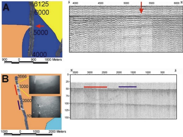
 Figure
8. Sidescan-sonar images across two areas interpreted to be gravel patches north of Grays
Harbor. The example in (A) suggests that the high-backscatter gravel patch occurs in a
subtle bathymetric depression on the corresponding seismic-reflection profile. The example
in (B) shows that the high-backscatter patches occur both above and away from paleo-river
valleys that were cut during the last lowstand of sea level. Bottom photographs show that
the low-backscatter areas have a surficial veneer of rippled fine sand while the
high-backscatter areas show the presence of gravel. Click on the figure to view a
larger image. Figure location shown in Fig.4.
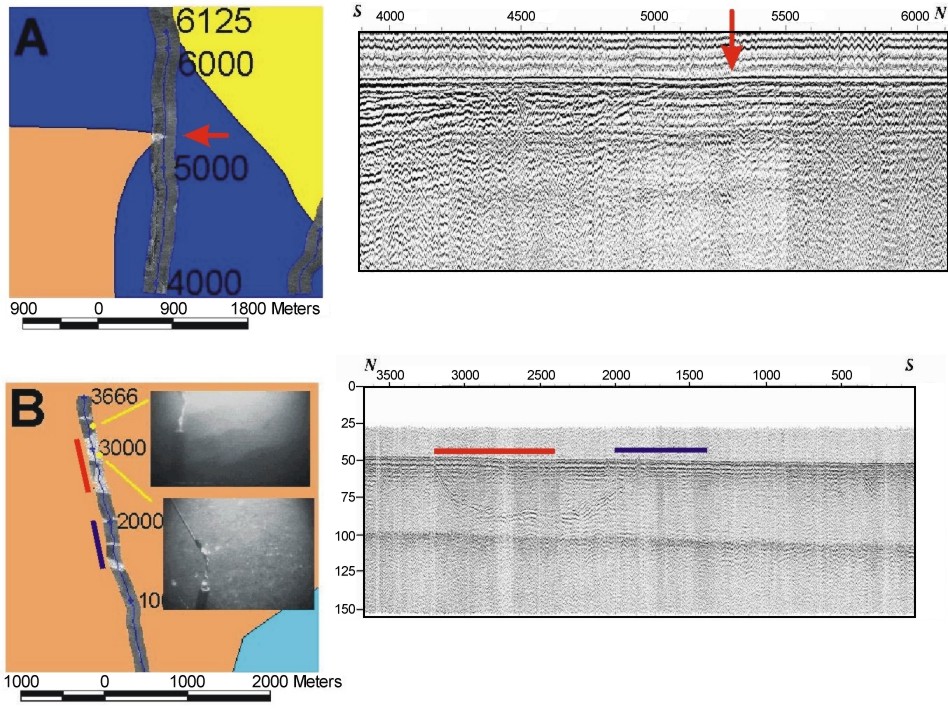
Figure
8. Sidescan-sonar images across two areas interpreted to be gravel patches north of Grays
Harbor. The example in (A) suggests that the high-backscatter gravel patch occurs in a
subtle bathymetric depression on the corresponding seismic-reflection profile. The example
in (B) shows that the high-backscatter patches occur both above and away from paleo-river
valleys that were cut during the last lowstand of sea level. Bottom photographs show that
the low-backscatter areas have a surficial veneer of rippled fine sand while the
high-backscatter areas show the presence of gravel. Click on the figure to view a
larger image. Figure location shown in Fig.4.
[an error occurred while processing this directive]
 Figure
8. Sidescan-sonar images across two areas interpreted to be gravel patches north of Grays
Harbor. The example in (A) suggests that the high-backscatter gravel patch occurs in a
subtle bathymetric depression on the corresponding seismic-reflection profile. The example
in (B) shows that the high-backscatter patches occur both above and away from paleo-river
valleys that were cut during the last lowstand of sea level. Bottom photographs show that
the low-backscatter areas have a surficial veneer of rippled fine sand while the
high-backscatter areas show the presence of gravel. Click on the figure to view a
larger image. Figure location shown in Fig.4.
Figure
8. Sidescan-sonar images across two areas interpreted to be gravel patches north of Grays
Harbor. The example in (A) suggests that the high-backscatter gravel patch occurs in a
subtle bathymetric depression on the corresponding seismic-reflection profile. The example
in (B) shows that the high-backscatter patches occur both above and away from paleo-river
valleys that were cut during the last lowstand of sea level. Bottom photographs show that
the low-backscatter areas have a surficial veneer of rippled fine sand while the
high-backscatter areas show the presence of gravel. Click on the figure to view a
larger image. Figure location shown in Fig.4.