Woods Hole Field Center Home Page Coastal and Marine Geology Program Home Page U.S. Geological Survey with link to U.S.G.S. Home Page
USGS Banner


National Assessment of Coastal Vulnerability to Sea-Level Rise: Preliminary Results for the U.S. Gulf of Mexico Coast


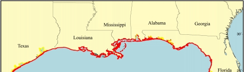
Figure 4.   Map of the geomorphology variable for the U.S. Gulf of Mexico coast. The shoreline is composed predominantly of very high-risk barrier island complexes, lagoons, marshes and deltas.

Click on map for larger image

Figure 4. Map of the geomorphology variable for the U.S. Gulf of Mexico coast.


 Contents  Back to Top  Title Page

 Introduction  Risk
Variables
 Data
Ranking
 C.V.I.  Results  Discussion  Summary  References

[an error occurred while processing this directive]