Woods Hole Field Center Home Page Coastal and Marine Geology Program Home Page U.S. Geological Survey with link to U.S.G.S. Home Page
USGS Banner


National Assessment of Coastal Vulnerability to Sea-Level Rise: Preliminary Results for the U.S. Gulf of Mexico Coast


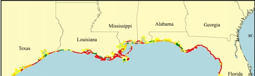
Figure 9.   Map of the erosion rate variable for the U.S. Gulf of Mexico coast. Most of the Gulf of Mexico coast receives a moderate to very high risk ranking, meaning the coastline is either stable or is eroding. There are few accreting areas.

Click on map for larger image

Figure 9.Map of the erosion rate variable for the U.S. Gulf of Mexico coast.


 Contents  Back to Top  Title Page

 Introduction  Risk
Variables
 Data
Ranking
 C.V.I.  Results  Discussion  Summary  References

[an error occurred while processing this directive]