U.S. Geological Survey Open-File Report 00-201
By Kirk A. Miller and Jon P. Mason
This Open File Report is also available as a pdf file. The page size is 34" x 44" and is 992KB.
The water-surface profile and flood boundaries for the computed 100-year flood were determined for a part of the lower Salt River in Lincoln County, Wyoming. Channel cross-section data were provided by Lincoln County. Cross-section data for bridges and other structures were collected and compiled by the U.S. Geological Survey. Roughness coefficients ranged from 0.034 to 0.100. The 100-year flood was computed using standard methods, ranged from 5,170 to 4,120 cubic feet per second through the study reach, and was adjusted proportional to contributing drainage area. Water-surface elevations were determined by the standard step-backwater method. Flood boundaries were plotted on digital basemaps.
Lincoln County officials need the 100-year flood boundaries identified for the Salt River to assist in development planning and flood-insurance purposes. As defined by the Federal Emergency Management Agency (FEMA), computation of the elevation profile and mapping of the inundation area for a 100-year flood constitutes a limited-detail study (U.S. Geological Survey, written commun., 1984). In cooperation with Lincoln County, the U.S. Geological Survey (USGS) completed a limited-detail flood study for a part of the lower Salt River.
 |
|
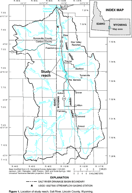
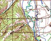
Figure 1. Location of study reach, Salt River, Lincoln County, Wyoming. |
This report describes the 100-year flood elevations for the Salt River from a point about 1-1/2 mi north of Thayne, Wyoming, upstream through "The Narrows" to the State Route 238 bridge (fig. 1). Open-channel cross-section geographic coordinates and elevations and bridge cross-section geographic coordinates were provided by Lincoln County. Bridge cross-section elevations were determined by the USGS. An initial 100-year flood discharge was determined using annual peak streamflows from streamflow-gaging station USGS 13027500 for the period 1954-97. The final flood discharges were decreased upstream proportionally to drainage area. The hydraulic analyses assumed steady, gradually-varied flow. Base-map information, specifically topographic data, are provided for general reference; flood elevations could be field surveyed to determine areas of inundation more precisely.
Ross Turner, Lincoln County, is acknowledged for assisting in the reduction and review of the channel surveying data. Ken Wahl, USGS, is acknowledged for his field assistance and for his hydrologic analyses.
The Salt River originates in the mountains of north-central Lincoln County, Wyoming and flows north through Star Valley toward its mouth at Palisades Reservoir (fig. 1). The study reach begins at a point about 1-1/2 mi north of Thayne and continues upstream through The Narrows to the State Route 238 bridge. Through the lower valley, the Salt River is a meandering stream with a broad floodplain; through The Narrows, the river is more confined. Strawberry Creek and Willow Creek are two major tributaries to the river in the study reach.
Annual streamflows of the Salt River are characteristic of systems dominated by snowmelt runoff from mountainous areas. Snowmelt runoff begins in April, with larger streamflows occurring in late May to early June, followed by a gradual recession. Streamflows recede through the fall and winter months to baseflow conditions. Flooding from thunderstorms is rare (Sando and others, 1985). Statistics of daily mean discharge from USGS streamflow-gaging station 13027500 (Salt River above Reservoir, near Etna, Wyoming; see fig. 1 for location) illustrating these streamflow characteristics are shown in figure 2.
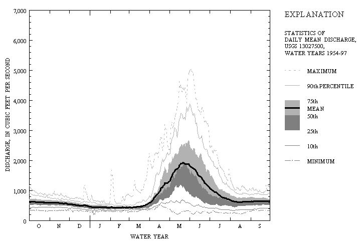
Figure 2. Statistics of daily mean discharge, USGS 13027500 Salt River above Reservoir, near Etna, Wyoming, water years 1954-97.
Annual instantaneous peak discharges for the Salt River as recorded at USGS 13027500 ranged from 691 to 5,090 ft3/s (fig. 3). More than half (26 of 45) of the annual peaks occurred in May; however, the largest recorded annual peak (5,090 ft3/s) occurred June 2, 1986. In addition to instantaneous peak discharges for the period of systematic record (1954-97), an annual maximum daily mean discharge of 2,380 ft3/s was recorded on June 17 and 18, 1918, at a site 5 mi downstream (Grover and others, 1922; Wells, 1956). Discharge records may not be comparable between the downstream site and USGS 13027500 (Nathan Jacobson, written commun., 2000).
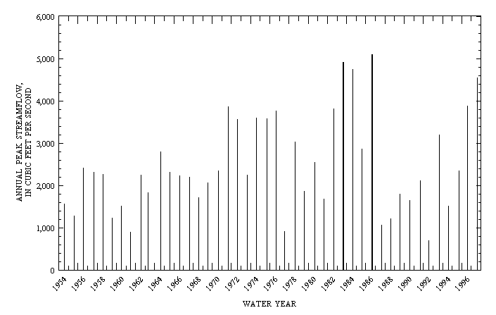
Figure 3. Annual peak streamflow, USGS 13027500 Salt River above Reservoir, near Etna, Wyoming, water years 1954-97.
Standard hydrologic and hydraulic methods were used to determine the water-surface profile and inundation boundaries for the 100-year flood through the lower Salt River study reach. The 100-year flood is that flood event expected to be equaled or exceeded once, on average, during any 100-year period (recurrence interval). A 100-year flood has a probability of 0.01 (1-percent chance) of being equaled or exceeded any given year. A recurrence interval or exceedance probability for an event does not imply that the event will not occur at shorter intervals or more than once within the same year.
Salt River peak streamflow characteristics were analyzed to determine their suitability for computing the 100-year flood discharge. Flood-frequency analyses assume annual peak discharge data are stationary with respect to time. Any significant trend in the data should be removed--or otherwise accounted for--prior to initiating the frequency analysis. Kendall's test statistic was used to determine if Salt River historical streamflows exhibited a statistically-significant trend (Helsel and Hirsch, 1992). Kendall's trend slope (23.0 ft3/s/yr), tau statistic (0.162), and significance level (p = 0.124) were computed for the instantaneous annual peak discharges from USGS 13027500 for the period 1954-97. No trend in peak streamflows is apparent at the 90-percent confidence level.
Analyses of streamflow data for the Salt River also have been completed by others. Sando and others (1985) examined streamflow characteristics relative to changing irrigation practices in the valley. The analyses used streamflow data from water years 1954-82. In 1971, about half of the irrigated acres in the valley were converted from flood to sprinkler irrigation. Sando and others (1985) compared May discharges from USGS 13027500 with USGS 13023000 (Greys River above Reservoir, near Alpine, Wyoming; not shown in figure 1), an adjacent basin that is predominantly forested and without irrigated agriculture. The comparison indicated a shift toward larger May discharges for the Salt River after 1971. Referencing Sando and others (1985), recent unpublished flood-frequency analyses by others used only the annual peak discharges after 1971 as representative of current flood-hazard conditions.
The double-mass comparison of the Salt and Greys Rivers was repeated using streamflow data through water year 1997 (Ken Wahl, written commun., 1998). This analysis indicated a shift toward smaller May discharges for the Salt River after 1986, returning to a relation with Greys River streamflows similar to that prior to 1971 (fig. 4). The reason for the second shift is not known; furthermore, additional analyses of these results are beyond the scope of this project. Based on the results of the trend test of peak discharges and lacking further analyses of the double-mass comparison of May discharges, the hypothesis that annual peak discharges prior to 1971 are not representative of current conditions was rejected.
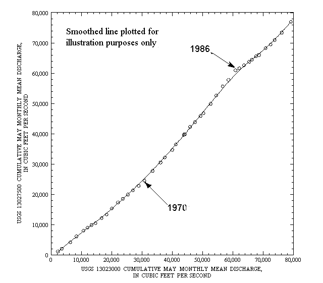
Figure 4. Double mass plot of May monthly mean discharges for USGS 13023000 (Greys River above Reservoir, near Alpine, Wyoming) and USGS 13027500 (Salt River above Reservoir, near Etna, Wyoming), 1954-97.
An initial estimate of 6,120 ft3/s for the 100-year flood was calculated for the Salt River near the mouth of the basin. This discharge has a 1-percent probability of being equaled or exceeded any given year (fig. 5). The estimate was calculated using the USGS computer program PEAKFQ (Thomas and others, written commun., 1998) in accordance with accepted methods described in Bulletin 17-B of the Hydrology Subcommittee of the Office of Water Data Coordination (Interagency Advisory Committee on Water Data, 1982). Instantaneous peak discharges from USGS 13027500 for the period 1954-97 were used in the analyses. The 1918 historic peak discharge at the site downstream was not used in the analyses because of the lack of ancillary data for the intervening period (1919-53) of no systematic record and because the discharge records may not be comparable between the sites (see Streamflow Characteristics section of this report). The weighted skew option was used in the program; no high-outlier or low-outlier criteria were used.
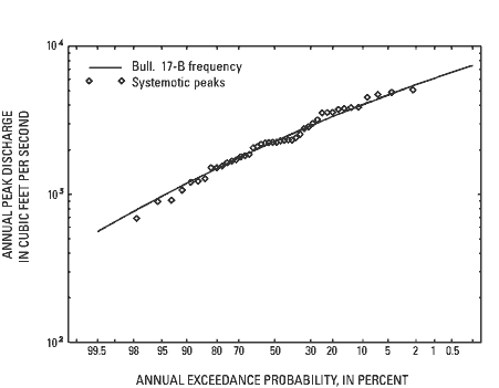
Figure 5. Exceedance probabilities and Bulletin 17-B
flood-frequency curve for instantaneous annual peak
discharges, USGS 13027500, Salt River above Reservoir, near
Etna, Wyoming, 1954-97.
Because USGS 13027500 is located several miles downstream from the study reach, the initial estimate of the 100-year flood was adjusted to account for decreased contributing drainage area. Drainage areas were delineated for the Salt River basin and the four principal tributaries downstream and through the reach--Jackknife Creek, Tincup Creek, Strawberry Creek, and Willow Creek (fig. 1). Delineation was completed manually on USGS 1:100,000-scale topographic maps.
The equation for estimating the 100-year peak discharge at an ungaged location of interest in the mountainous regions of Wyoming as determined by Lowham (1988) is:
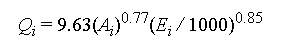
where for the location of interest:
Qi is the estimated 100-year peak discharge;
Ai is the drainage area; and
Ei is the mean basin elevation.
The 100-year peak discharge for the Salt River estimated at USGS 13027500 using the PEAKFQ program was decreased with decreasing drainage area resulting in incremental discharges at each of the tributaries. The incremental discharges were computed using the relation from Lowham (1988) expressed as the ratio of the incremental discharge to the discharge at USGS 13027500 as:
where:
Q0 is the computed 100-year peak discharge at USGS 13027500; and
A0 is the drainage area of the Salt River at USGS 13027500.
The change in mean basin elevation through the study reach is small; therefore, the factor Ei/E0 was assumed to be 1. The adjusted estimates of the 100-year flood are listed in table 1.
| Location | Salt River drainage area (mi2) |
100-year flood discharge (ft3/s) |
Remarks |
|---|---|---|---|
| USGS 13027500 | 829 | 6,120 | |
| Jackknife Creek | 759 | 5,720 | |
| Tincup Creek | 666 | 5,170 | |
| -- | 5,170 | Downstream end of study reach | |
| Strawberry Creek | 532 | 4,350 | |
| Willow Creek | 497 | 4,120 | |
| -- | 4,120 | Upstream end of study reach |
Salt River channel geometry and hydraulic properties were compiled for hydraulic analyses of the 100-year flood. Hydraulic analyses were completed using the standard step-backwater method (Davidian, 1984). This method of analysis requires channel and bridge cross-section station and elevation data, estimates of the cross-section hydraulic roughness coefficients, and flow lengths between cross sections.
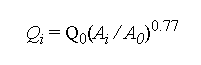
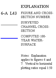
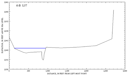
Lincoln County personnel provided open-channel cross-section station and elevation data for the hydraulic analyses. U.S. Geological Survey personnel estimated cross-section spacing based on requirements of the standard step-backwater method. Approximate cross-section locations were plotted on USGS 7-1/2 minute topographic quadrangle maps. Lincoln County personnel surveyed cross-section station and elevation data at or near these locations. The cross section geographic coordinates were based on a local coordinate system. Cross-section stationing was modified to meet computer program requirements. Specifically, for some cross sections stationing was changed to a consistent left-to-right scheme, and stationing was corrected for cross-section bends. Plots of surveyed channel cross sections typical of the study reach are shown in figures 6-A to 6-C.
 |
 |
 |
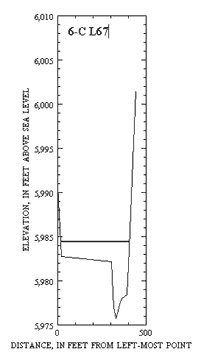 |
| Figures 6-A to 6-C. Cross-sections typical of channel and flood-plain conditions in the lower, middle, and upper parts of the study reach. | |
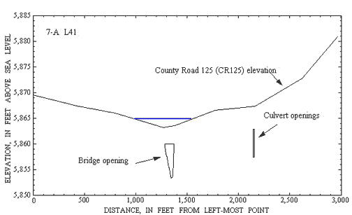
The USGS surveyed bridge-section station and elevation data for backwater analyses at road crossings. In addition to the bridge geometry, approach and exit sections were surveyed at most bridge sites. Also surveyed were bridge details including low-steel elevation, wingwall and pier geometries, and road cross-section data. Bridge-section reference points were established by the USGS and tied to a local coordinate system by Lincoln County. Plots of typical bridge and road-crossing sections are shown in figures 7-A and 7-B.
 |
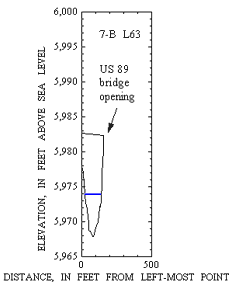 |
Figures 7-A and 7-B. Cross-sections typical of bridge and road-crossing conditions in the lower and upper parts of the study reach. | |
The USGS determined roughness coefficients (Manning's n) from field observations and comparison with verified coefficients (Barnes, 1967) and from review of aerial photographs. Manning's n quantifies the resistance to flow in stream channels and flood plains (Arcement and Schneider, 1989). Flow resistance is the primary energy loss accounted for in step-backwater computations. In addition to bed material composition and size, roughness is affected by surface irregularities, variations in channel morphology, flow obstructions, amount and type of vegetation, and degree of meandering. Values for Manning's n ranged from 0.034 to 0.040 for the main channel and 0.045 to 0.100 for the flood plain.
The distances between cross sections, or flow lengths, were scaled from plan-view plots of the data. Flow lengths determine slope values required for step-backwater computations. Surveyed cross-section geographic coordinates were converted from local coordinates to the State Plane Coordinate System (SPCS, Wyoming, Zone IV, West) using a conversion provided by Lincoln County (Ross Turner, written commun., 1998). Double-precision geographic information system (GIS) coverages were generated from the converted coordinate data. The GIS cross-section coverages were projected to the Universal Transverse Mercator (Zone 12) map projection, overlaid with USGS 1:24,000-scale hydrography digital line graphs (DLGs), and plotted at a scale of 1:7,200 (1 in = 600 ft). Lines representing stream channels were compared with aerial photographs and adjusted where major channel changes were noted.
Water-surface elevations for the 100-year flood were computed using the water-surface profile computer program WSPRO, which is based on the standard step-backwater method (Shearman, 1990). For subcritical flow, the program steps upstream, computing water-surface elevations at each cross section using a given discharge and channel hydraulic properties to balance the total energy head at the sections. The standard step method assumes one-dimensional flow between cross sections. That is, between any two consecutive cross sections, variations in flow direction are not directly modeled, but are accounted for in the roughness coefficients, flow lengths, and elevation change between the sections; and, the flow amount is assumed to remain steady through time.
The FEMA contracted to complete a similar flood study downstream of the USGS study reach. The upstream cross-section of the FEMA reach is coincident with the downstream cross-section of the USGS reach. To ensure the water-surface elevations and flood boundaries would be the same where the study reaches meet, the computed water-surface elevation at the upstream-most FEMA cross-section was used as the starting water-surface elevation for the USGS reach.
Template cross-sections (cross sections derived from nearby surveyed cross sections) were used between several surveyed cross-sections where WSPRO computations resulted in critical or supercritical flows without physical basis. The template cross-sections were located upstream, downstream, or both upstream and downstream of surveyed sections. Template cross-section elevations were adjusted using average channel slopes between two or more adjacent surveyed sections. Widths of some template cross-sections were adjusted for more gradual transitions between surveyed sections with different geometries. Use of template cross-sections did not resolve all conveyance problems. Template cross-sections were used only to minimize computational errors and may not be representative of actual channel conditions.
Water-surface elevations from cross-section L39 to cross-section L42 in the vicinity of County Road 125 (CR125) northwest of Thayne were determined separate from the rest of the study reach. Historical information, field observations, and preliminary computations indicated a discharge of 5,130 ft3/s would create sufficient backwater at CR125 to flow over the bridge and through the culverts on Flat Creek. For this reason, separate WSPRO computations were completed for Flat Creek and the Salt River. The culvert capacities were estimated and the resulting discharge used to compute water-surface elevations for Flat Creek. The discharge for the Salt River for the same reach was reduced by that amount and water-surface elevations were computed. The difference in water-surface elevations for both computations at the approach section to CR125 (cross-section L41_4) were compared. The discharges were adjusted with the intent of minimizing that difference and the water-surface elevations were computed again. This iterative process was repeated until the water-surface elevations at the approach to CR125 were within 0.2 ft of each other.
Water-surface elevations near the northernmost bridge in the study reach on U.S. Highway 89 (Bridge 96.20; cross-sections L59_1 and L59_4) are of questionable accuracy because of hydraulic computation problems. Because of the relative steepness of the channel immediately downstream of the bridge, an initial unconstricted water-surface elevation could not be determined by the WSPRO model. As a result, computed water-surface elevations through the bridge opening and immediately upstream of the bridge are based on the critical water-surface elevation and may not represent actual hydraulic conditions
The continuous water-surface profile for the study reach was determined by assuming a linear change between computed cross-section water-surface elevations. Water-surface elevations at surveyed cross-sections (table 2) were plotted against the cumulative flow length for the study reach (figures 8-A to 8-C). Because template cross-sections may not represent actual channel conditions, water-surface elevations at template cross-sections are not listed in table 2 or shown in figures 8-A to 8-C and template cross-section locations are not shown in figure 9.
| Cross-section | Water-surface elevation (feet above sea level) |
Cross-section | Water-surface elevation (feet above sea level) |
|---|---|---|---|
| L37 | 5837.9 | L56 | 5936.1 |
| L38 | 5844.2 | L57 | 5940.9 |
| L39 | 5851.3 | L58 | 5949.7 |
| L40 | 5855.6 | L59_1 | 5952.8 |
| CR 125 Bridge | 5864.9 | US Hwy 89 Bridge 96.20 | 5953.8 |
| L41_4 | 5865.1 | L59_4 | 5957.0 |
| L42 | 5867.0 | L60 | 5958.2 |
| L43 | 5873.4 | L61 | 5961.7 |
| L44 | 5879.8 | L62 | 5964.8 |
| L45 | 5893.1 | L63 | 5969.0 |
| L46 | 5896.2 | L64_1 | 5973.0 |
| L47 | 5898.3 | US Hwy 89 Bridge 95.19 | 5973.9 |
| L48 | 5904.7 | L64_4 | 5976.4 |
| L49 | 5908.2 | L65 | 5980.1 |
| L50 | 5912.4 | L66 | 5982.4 |
| L51 | 5917.5 | L67 | 5984.4 |
| L52 | 5924.9 | L68 | 5985.8 |
| L53 | 5927.7 | L69 | 5987.0 |
| L54 | 5933.0 | L70_1 | 5987.4 |
| L55 | 5934.4 | ||
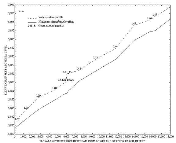
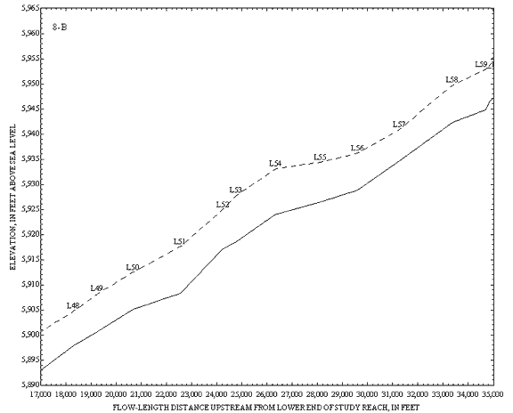
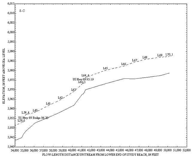
Figures 8-A to 8-C. Profiles of computed water-surface elevations for the 100-year flood, minimum streambed elevations, and locations of surveyed open-channel and bridge sections
The boundaries for the area inundated by the 100-year flood were determined from the computed water-surface profiles. The GIS cross-section coverages were plotted on USGS 1:24,000-scale digital raster graphics (DRGs) (fig. 9). The intersection of the 100-year flood elevation with the surveyed ground elevation was computed by the WSPRO model for each cross section. The model output those data as the distances in feet from the left-most cross-section station (determined facing downstream) to the left- and right-edges of water. These distances were measured along the cross-section traces on the DRG and marked as the computed extent of inundation at each cross section. The 100-year flood boundaries were plotted on the DRGs assuming a constant change in water-surface elevations between cross sections. That is, the flood boundaries represent the trace of the intersection of the flat, sloping plane of the water surface with the underlying irregular land surface. Topographic data, roads, and canals on the DRGs and recent aerial photographs and field observations were reviewed for assistance in plotting the flood boundaries between cross sections.
 |
This map is available only as a pdf file. This map is 27"X36" and is 619K. |
|
Figure 9. Locations of surveyed cross-sections and flood boundaries for the computed 100-year flood, lower Salt River, Lincoln County, Wyoming.
|
|
The use of USGS 7.5-minute series (1:24,000-scale) topographic maps as the base maps for the flood boundaries was determined at the inception of the study. The DRGs used were the best available representations of these maps at the time of the study. In some instances, the locations of the flood boundaries are inconsistent with topographic and hydrographic data on the DRGs. The definitive source of these inconsistencies was not determined; however, several factors might have contributed to them. The dates of the DRG source maps range from 1980 to 1981. Based on field observations and review of aerial photographs, channel conditions have changed since then. Conversion of the survey data from the local coordinate system to a map projection may be a source of error in plotting the cross sections. Also, horizontal accuracy of 90 percent of the points on a 1:24,000-scale map is less than or equal to 40 ft from their true positions (Thompson, 1988). More precise determination of the extent of inundation could be determined at any particular location using the computed water-surface elevation and detailed field surveys of the land surface.
Inundated areas with minimal or no flow were identified near the bridges on U.S. Highway 89. From the available data, the elevations of these zones are low enough that they would be inundated. Because of their location relative to the main channel, there would probably be little or no velocity in these zones. Inundation is probable for the area left of the main channel and upstream of the southernmost bridge on U.S. Highway 89 (Bridge 95.19 near cross-sections L64_1 and L64_4). Land-surface elevations west of U.S. Highway 89 at cross-section L63 are lower than the computed water-surface elevations upstream of Bridge 95.19. A more accurate determination of the area of inundation would require surveyed elevations of built-up areas on the left-bank upstream of Bridge 95.19. In addition to areas with minimal or no flow identified in figure 9, other segments with little or no flow near the flood boundaries may occur near the right flood boundary near cross-sections L55 and L58.
Lincoln County officials need the 100-year flood boundaries identified for the Salt River to assist in development planning and flood-insurance purposes. In cooperation with Lincoln County, the U.S. Geological Survey (USGS) completed a limited-detail flood study for a part of the lower Salt River. The study reach begins at a point about 1-1/2 mi north of Thayne and continues upstream through The Narrows to the State Route 238 bridge.
Annual streamflows of the Salt River are characteristic of systems dominated by snowmelt runoff from mountainous areas. Annual instantaneous peak discharges for the Salt River as recorded at USGS 13027500 ranged from 691 to 5,090 ft3/s. Statistical tests revealed no trends through time; thus, all peak discharge data were used in the analyses. Final adjusted estimates of the 100-year flood for the study reach ranged from 5,170 to 4,120 ft3/s (downstream to upstream).
Salt River channel geometry and hydraulic properties were compiled for hydraulic analyses of the 100-year flood. Lincoln County personnel provided open-channel cross-section station and elevation data. The USGS surveyed bridge-section station and elevation data. Lincoln County personnel referenced all cross-section data to a local coordinate system. Manning's n determined by the USGS ranged from 0.034 to 0.040 for the main channel and 0.045 to 0.100 for the flood plain. Flow lengths were measured on scaled GIS plots.
Water-surface elevations for the 100-year flood were computed using the water-surface profile computer model WSPRO. The ending water-surface elevation from an adjacent FEMA limited-detail study was used as the starting water-surface elevation for the study reach. Template cross-sections were used between several surveyed cross-sections where WSPRO model computations resulted in critical or supercritical flows without physical basis. Water-surface elevations in the vicinity of CR125 northwest of Thayne were determined separate from the rest of the study reach using an iterative approach. Water-surface elevations through Bridge 96.20 may be uncertain because of WSPRO computational problems.
The boundaries for the area inundated by the 100-year flood were plotted on USGS 1:24,000-scale DRGs. Topographic data, roads, and canals on the DRGs and recent aerial photographs and field observations were reviewed for assistance in plotting the flood boundaries between cross sections. Locations of the flood boundaries in some segments are inconsistent with topographic and hydrographic data on the DRGs. Inundated areas with little or no flow were identified. More precise determination of the extent of inundation could be determined at any given location using the computed water-surface elevation and detailed field surveys of the land surface.
Arcement, George J., Jr., and Schneider, Verne R., 1989, Guide for selecting Manning's roughness coefficients for natural channels and flood plains: U.S. Geological Survey Water-Supply Paper 2339, 38 p.
Barnes, H.H., Jr., 1967, Roughness characteristics of natural channels: U.S. Geological Survey Water-Supply Paper 1849, 213 p.
Beartooth Mapping, 1999, Wyoming DRG-E quadrangle name index (PDF version): Red Lodge, Montana, Beartooth Mapping, Inc., 48 p.
Davidian, J., 1984, Computation of water-surface profiles in open channels: U.S. Geological Survey Techniques of Water-Resources Investigations, book 3, chapter A15, 48 p.
Grover, N.C., Baldwin, G.C., Parker, G.L., Purton, A.B., and Henshaw, F.F, 1922, Surface water supply of the United States, 1918--Part XII. North Pacific drainage basins, B. Snake River Basin: U.S. Geological Survey Water-Supply Paper 483, p. 56-57.
Helsel, D.R., and Hirsch, R.M., 1992, Statistical methods in water resources: New York, Elsevier Science Publishing Co., Inc., 522 p.
Interagency Advisory Committee on Water Data, 1982, Guidelines for determining flood flow frequency: Bulletin 17-B of the Hydrology Subcommittee, Office of Water Data Coordination, U.S. Geological Survey, Reston, Virginia, 183 p.
Lowham, H.W., 1988, Streamflows in Wyoming: U.S. Geological Survey Water-Resources Investigations Report 88-4045, 78 p.
Sando, S.K., Borrelli, J., and Brosz, D.J., 1985, Effects of increased irrigation efficiencies on the streamflow of the Salt River, in Rocky Mountain Regional Meeting, American Society of Agricultural Engineers, Grand Junction, Colorado, 1985, Proceedings: St. Joseph, Michigan, American Society of Agricultural Engineers, variable pagination.
Shearman, J.O., 1990, User's manual for WSPRO--A computer model for water surface profile computations: Federal Highway Administration Report FHWA-IP-89-027, 177 p.
Thomas, W.O., Jr., Lumb, A.M., Flynn, K.M., and Kirby, W.H., 1998, Users manual for program PEAKFQ, annual flood frequency analysis using Bulletin 17B guidelines: written communication, 89 p. <http://water.usgs.gov/software/peakfq.html>
Thompson, M.M., 1988, Maps for America--Cartographic products of the U.S. Geological Survey and others, Washington, D.C., 265 p.
Wells, J.V.B., 1956, Surface water supply of the United States, 1954--Part 13. Snake River Basin: U.S. Geological Survey Water-Supply Paper 1347, p. 26.
| AccessibilityFOIAPrivacyPolicies and Notices | |
 |
|