Title: Thickness of Post-Glacial Sediments in LIS - vectors
Publication_Information:
Publication_Place: Woods Hole Field Center, Woods Hole, MA
Publisher: U.S. Geological Survey
Larger_Work_Citation:
Citation_Information:
Originator: Valerie Paskevich(ed.)
Originator: Larry Poppe(ed.)
Publication_Date: 20000000
Title:
Georeferenced sea-floor mapping and bottom photography in Long Island Sound
Series_Information:
Series_Name: U.S. Geological Survey Open-File Report
Issue_Identification: OFR 00-304
Publication_Information:
Publication_Place: Woods Hole Field Center, Woods Hole, MA
Publisher: U.S. Geological Survey
Description:
Abstract:
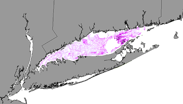
This GIS layer contains an interpretive layer represented by contour lines
of the thickness of postglacial sediments in Long Island Sound.
Purpose:
The purpose is to disseminate the digital version of a regional map showing
the thickness of the postglacial sediments in Long Island Sound
Time_Period_of_Content:
Time_Period_Information:
Single_Date/Time:
Calendar_Date: 20000721
Currentness_Reference: Publication Date
Status:
Progress: Complete
Maintenance_and_Update_Frequency: None planned
Spatial_Domain:
Bounding_Coordinates:
West_Bounding_Coordinate: -73.7717
East_Bounding_Coordinate: -72.0526
North_Bounding_Coordinate: 41.3439
South_Bounding_Coordinate: 40.8226
Keywords:
Theme:
Theme_Keyword_Thesaurus: General
Theme_Keyword: U.S. Geological Survey
Theme_Keyword: USGS
Theme_Keyword: Coastal and Marine Geology Team
Theme_Keyword: Coastal and Marine Geology Program
Theme_Keyword: Woods Hole Field Center
Theme_Keyword: Connecticut Department of Environmental Protection
Theme_Keyword: Long Island Sound Resource Center
Theme_Keyword: University of Connecticut
Theme_Keyword: ArcView
Theme_Keyword: arcview
Theme_Keyword: shapefile
Theme_Keyword: vectors
Theme_Keyword: contour lines
Theme_Keyword: interpretation
Theme_Keyword: thickness of postglacial sediments
Place:
Place_Keyword_Thesaurus: General
Place_Keyword: Long Island Sound
Place_Keyword: Connecticut
Place_Keyword: New York
Access_Constraints: None
Use_Constraints:
Although this derived data set and its lineage dataset have been used
by the USGS and the University of Connecticut, no warranty, expressed or
implied, is made by either the USGS or the University of Connecticut as
to the accuracy of the data and/or related materials.
The act of distribution shall not constitute any such warranty, and no
responsibility is assumed by either the USGS or the University of Connecticut
in the use of these data or related materials. The Long Island Sound Resource
Center at the University of Connecticut must be referenced as the originator
of the dataset in any future products or research derived from these data.
Point_of_Contact:
Contact_Information:
Contact_Organization_Primary:
Contact_Organization: Long Island Sound Resource Center
image showing the extent of the GIS layer of the postglacial sediments
in LIS
Security_Information:
Security_Handling_Description: Not Applicable
Security_Classification: Unclassified
Security_Classification_System: None
Native_Data_Set_Environment:
ArcView version 3.2 shapefile format - lissound\data\chap01\pgthkl.shp
Cross_Reference:
Citation_Information:
Originator: Ralph S. Lewis(comp.)
Originator: Mary DiGiacomo-Cohen(comp.)
Publication_Date: 20000000
Title:
A review of the geologic framework of the Long Island Sound Basin with
some observations related to postglacial sedimentation
Geospatial_Data_Presentation_Form: map
Publication_Information:
Publication_Place: Fort Lauderdale, FL
Publisher: Coastal Education and Research Foundation
Data_Quality_Information:
Attribute_Accuracy:
Attribute_Accuracy_Report:
The thickness attribute is in meters and was derived from analog records
by a generated Uniboom seismic system. The Uniboom employed for this project
gave a penetration averaging 50 m and a resolution of 1-2 m.
Quantitative_Attribute_Accuracy_Assessment:
Attribute_Accuracy_Value: 1-2 m
Attribute_Accuracy_Explanation: Ship motion and equipment limitations
result in this accuracy.
Logical_Consistency_Report:
No additional checks for topological consistency were performed on this
data set.
Completeness_Report: none
Positional_Accuracy:
Horizontal_Positional_Accuracy:
Horizontal_Positional_Accuracy_Report:
Ship position was determined using Loran-C and fixes were recorded every
5 minutes and at course changes. 185-460 m absolute accuracy Typical accuracy
for nonrepetitvie or absolute navigation with Loran-C
Lineage:
Source_Information:
Source_Citation:
Citation_Information:
Originator: R.S. Lewis(comp.)
Originator: S.W. Nedell(comp.)
Publication_Date: 19870000
Publication_Time: Unknown
Title:
Maps showing stratigraphic framework and Quaternary geologic history of
eastern Long Island Sound
Series_Information:
Series_Name: U.S. Geological Survey Miscellaneous Field Studies
Map
Issue_Identification: MF-1939-A
Source_Scale_Denominator: 80000
Type_of_Source_Media: mylar
Source_Time_Period_of_Content:
Time_Period_Information:
Single_Date/Time:
Calendar_Date: 19820000
Source_Currentness_Reference: Ground Condition
Source_Citation_Abbreviation: Eastern Long Island Sound hand drawn
contours
Source_Contribution:
Data from the original analog seismic-reflections profiles were hand plotted
and contoured at 80,000 on mylar.
Source_Information:
Source_Citation:
Citation_Information:
Originator: S.W. Needell(comp.)
Originator: R.S. Lewis(comp.)
Originator: S.M. Colman(comp.)
Publication_Date: 19870000
Title:
Maps showing the Quaternary geology of east-central Long Island Sound
Series_Information:
Series_Name: U.S. Geological Survey Miscellaneous Field Studies
Map
Issue_Identification: MF-1939-B
Source_Scale_Denominator: 80000
Type_of_Source_Media: mylar
Source_Time_Period_of_Content:
Time_Period_Information:
Single_Date/Time:
Calendar_Date: 19830000
Source_Currentness_Reference: Ground Condition
Source_Citation_Abbreviation: East-central Long Island Sound hand
drawn contours
Source_Contribution:
Data from the original analog seismic-reflections profiles were hand plotted
and contoured at 80,000 on mylar.
Source_Information:
Source_Citation:
Citation_Information:
Originator: R.S. Lewis(comp.)
Originator: N.F. Neff(comp.)
Publication_Date: Unknown
Title: Unpublished data from various high resolution seismic cruises
Source_Scale_Denominator: 80000
Type_of_Source_Media: mylar
Source_Time_Period_of_Content:
Time_Period_Information:
Multiple_Dates/Times:
Single_Date/Time:
Calendar_Date: 19840000
Single_Date/Time:
Calendar_Date: 19850000
Source_Currentness_Reference: Ground Condition
Source_Citation_Abbreviation: Western and west-central Long Island
Sound hand drawn contours
Source_Contribution:
Data from the original analog seismic-reflections profiles were hand plotted
and contoured at 80,000 on mylar.
Process_Step:
Process_Description:
These hand drawn contours were digitzed from mylar originals using Arc/Info
software. The digitzed data were joined with other Long Island Sound sections
(contours were modified where necessary to match at section boundaries)
and then converted to ArcView shapefile format.
Source_Used_Citation_Abbreviation: Eastern Long Island Sound hand
drawn contours
Source_Used_Citation_Abbreviation: East-central Long Island Sound
hand drawn contours
Source_Used_Citation_Abbreviation: Western and west-central Long Island Sound hand drawn contours
Process_Date: Unknown
Source_Produced_Citation_Abbreviation: pgthkl.dbf
Source_Produced_Citation_Abbreviation: pgthkl.shp
Source_Produced_Citation_Abbreviation: pgthkl.shx
Process_Contact:
Contact_Information:
Contact_Organization_Primary:
Contact_Organization: Long Island Sound Resource Center
Altitude_Datum_Name: National Geodetic Vertical Datum of 1929
Altitude_Resolution: 1-2 m
Altitude_Distance_Units: Meters
Altitude_Encoding_Method: Attribute values
Depth_System_Definition:
Depth_Datum_Name: Local surface
Depth_Resolution: 1-2 m
Depth_Distance_Units: Meters
Depth_Encoding_Method: Attribute values
Entity_and_Attribute_Information:
Detailed_Description:
Entity_Type:
Entity_Type_Label: pgthkl.dbf
Entity_Type_Definition: Shapefile attribute file
Entity_Type_Definition_Source: ESRI
Attribute:
Attribute_Label: Fnode_
Attribute_Definition: From-node identifier of linear feature.
Attribute_Definition_Source: software computed
Attribute_Domain_Values:
Range_Domain:
Range_Domain_Minimum: 10
Range_Domain_Maximum: 4536
Attribute:
Attribute_Label: Tnode_
Attribute_Definition: To-node identifier of linear feature.
Attribute_Definition_Source: software computed
Attribute_Domain_Values:
Range_Domain:
Range_Domain_Minimum: 30
Range_Domain_Maximum: 4537
Attribute:
Attribute_Label: Lpoly_
Attribute_Definition:
Internal number of polygon to left of arc. This is a carry over field from
the Arc/Info coverage and has no relevance to the use of the dataset.
Attribute_Definition_Source: software computed
Attribute_Domain_Values:
Range_Domain:
Range_Domain_Minimum: 0
Range_Domain_Maximum: 0
Attribute:
Attribute_Label: Rpoly_
Attribute_Definition:
Internal number of polygon to right of arc. This is a carry over field
from the Arc/Info coverage and has no relevance to the use of the dataset.
Attribute_Definition_Source: software computed
Attribute_Domain_Values:
Range_Domain:
Range_Domain_Minimum: 0
Range_Domain_Maximum: 0
Attribute:
Attribute_Label: Length
Attribute_Definition: Length of line
Attribute_Definition_Source: software computed
Attribute_Domain_Values:
Range_Domain:
Range_Domain_Minimum: 457.730
Range_Domain_Maximum: 97607.305
Attribute:
Attribute_Label: Pgthkl_
Attribute_Definition:
Carried over from the ArcInfo attribute PGTHKL#. PGTHKL# is an ArcInfo
internal control parameter and has no applicable relevance to the use of
the data.
Attribute_Definition_Source: User Defined
Attribute_Domain_Values:
Range_Domain:
Range_Domain_Minimum: 1
Range_Domain_Maximum: 778
Attribute:
Attribute_Label: Pgthkl_id
Attribute_Definition:
Carried over from the ArcInfo attribute PGTHKL-ID. PGTHKL-ID is an ArcInfo
internal control parameter and has no applicable relevance to the use of
the data.
Attribute_Definition_Source: User Defined
Attribute_Domain_Values:
Range_Domain:
Range_Domain_Minimum: 1
Range_Domain_Maximum: 778
Attribute:
Attribute_Label: Thickness_
Attribute_Definition:
This value is the thickness of the postglacial marine sediments in meters.
Attribute_Definition_Source: User Defined
Attribute_Domain_Values:
Range_Domain:
Range_Domain_Minimum: 0
Range_Domain_Maximum: 45
Attribute_Units_of_Measure: meters
Attribute_Measurement_Resolution: 1
Beginning_Date_of_Attribute_Values: 19820000
Ending_Date_of_Attribute_Values: 19850000
Attribute_Value_Accuracy_Information:
Attribute_Value_Accuracy: 1 - 2 m
Attribute_Value_Accuracy_Explanation:
Ship motion and equipment limitations result in this accuracy
Attribute:
Attribute_Label: Dash
Attribute_Definition:
Y/N - Dashed lines denote sparse data or the necessity for interpolation.
Attribute_Definition_Source: User Defined
Attribute_Domain_Values:
Unrepresentable_Domain: Character field
Overview_Description:
Entity_and_Attribute_Overview:
This attribute (the thickness of postglacial sediments) tells us about
the sedimentary environments in the Long Island Sound Basin.
Entity_and_Attribute_Detail_Citation:
Maps showing the shape of the marine transgressive surface and the thickness
of postglacial sediments in Long Island Sound, DiGiacomo-Cohen and Lewis
Distribution_Information:
Distributor:
Contact_Information:
Contact_Organization_Primary:
Contact_Organization: Long Island Sound Resource Center
Resource_Description: Long Island Sound: pgthkl.shp
Distribution_Liability:
Although this derived data set and its lineage dataset have been used
by the USGS and the University of Connecticut, no warranty, expressed or
implied, is made by either the USGS or the University of Connecticut as
to the accuracy of the data and/or related materials. The act of distribution
shall not constitute any such warranty, and no responsibility is assumed
by either the USGS or the University of Connecticut in the use of these
data or related materials.
Standard_Order_Process:
Digital_Form:
Digital_Transfer_Information:
Format_Name: ARCV
Format_Information_Content:
pgthkl.dbf
pgthkl.shp
pgthkl.shx
pgthkl.avl
pgthkl.sbn
pgthkl.sbx
File_Decompression_Technique: No compression applied
Transfer_Size: 1609Kbytes
Digital_Transfer_Option:
Offline_Option:
Offline_Media: CD-ROM
Recording_Capacity:
Recording_Density: 650
Recording_Density_Units: Mbytes
Recording_Format: ISO 9600
Compatibility_Information:
The user must have a system with a CD-ROM capable of reading an ISO-9660
standard CD-ROM disk. To browse the information contained on this disk,
the user must also have a current version of WWW browser available.
Digital_Form:
Digital_Transfer_Information:
Format_Name: ARCV
Format_Information_Content:
The six ArcView files (pgthkl.dbf, pgthkl.shp, pgthkl.shx, pgthkl.avl,
pgthkl.sbn, pgthkl.sbx) comprising the thickness of postglacial sediments
in Long Island Sound.
File_Decompression_Technique: zip
Transfer_Size: 549Kbytes
Digital_Transfer_Option:
Offline_Option:
Offline_Media: CD-ROM
Recording_Capacity:
Recording_Density: 650
Recording_Density_Units: Mbytes
Recording_Format: ISO 9600
Compatibility_Information:
The user must have a system with a CD-ROM capable of reading an ISO-9660
standard CD-ROM disk. To browse the information contained on this disk,
the user must also have a current version of WWW browser available. The
user must also have the software installed on their computer system capable
to unzip the archived file.
Fees: none
Custom_Order_Process: None
Technical_Prerequisites:
The pgthkl overlay is available in an ArcView shapefile format. The user
must have ESRI's ArcView 3.0 or greater software to read and process the
data file. In lieu of Arcview, the user may utilize another GIS application
package capable of importing the data.