Title: Free-air gravity of Long Island and Block Island Sounds
Publication_Information:
Publication_Place: Woods Hole Field Center, Woods Hole, MA
Publisher: U.S. Geological Survey
Larger_Work_Citation:
Citation_Information:
Originator: Valerie Paskevich(ed.)
Originator: Larry Poppe(ed.)
Publication_Date: 20000000
Publication_Time: Unknown
Title:
Georeferenced Sea-Floor Mapping and Bottom Photography in Long Island Sound
Series_Information:
Series_Name: U. S. Geological Survey Open-File Report
Issue_Identification: OFR 00-304
Publication_Information:
Publication_Place: Woods Hole Field Center, Woods Hole, MA
Publisher: U. S. Geological Survey
Description:
Abstract:
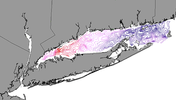
This GIS layer contains an interpretive layer represented by contour lines
(2-mgal intervals) of the free-air gravity of Long Island and Block Island
Sounds
Purpose:
The purpose is to disseminate the only existing free-air gravity information
in digital form to the research community, and to facilitate modern geophysical
and environmental studies of the Sounds.
Time_Period_of_Content:
Time_Period_Information:
Single_Date/Time:
Calendar_Date: 1975
Currentness_Reference: Ground Condition
Status:
Progress: Complete
Maintenance_and_Update_Frequency: None planned
Spatial_Domain:
Bounding_Coordinates:
West_Bounding_Coordinate: -73.7099
East_Bounding_Coordinate: -71.5563
North_Bounding_Coordinate: 41.3909
South_Bounding_Coordinate: 40.8512
Keywords:
Theme:
Theme_Keyword_Thesaurus: General
Theme_Keyword: U.S. Geological Survey
Theme_Keyword: USGS
Theme_Keyword: Coastal and Marine Geology Team
Theme_Keyword: Coastal and Marine Geology Program
Theme_Keyword: Woods Hole Field Center
Theme_Keyword: Connecticut Department of Environmental Protection
Theme_Keyword: Long Island Sound Resource Center
Theme_Keyword: University of Connecticut
Theme_Keyword: ArcView
Theme_Keyword: arcview
Theme_Keyword: shapefile
Theme_Keyword: vectors
Theme_Keyword: contour lines
Theme_Keyword: interpretation
Theme_Keyword: free-air gravity
Place:
Place_Keyword_Thesaurus: General
Place_Keyword: Long Island Sound
Place_Keyword: Block Island Sound
Place_Keyword: Connecticut
Place_Keyword: New York
Access_Constraints: None
Use_Constraints:
Although this derived data set and its lineage dataset have been used
by the USGS, the Connecticut Department of Environmental Protection, and
the University of Connecticut, no warranty, expressed or implied, is made
by either the USGS or the University of Connecticut as to the accuracy
of the data and/or related materials.
The act of distribution shall not constitute any such warranty, and no
responsibility is assumed by either the USGS, the Connecticut Department
of Environmental Protection, or the University of Connecticut in the use
of these data or related materials. The Long Island Sound Resource Center
at the University of Connecticut must be referenced as the originator of
the dataset in any future products or research derived from these data.
Point_of_Contact:
Contact_Information:
Contact_Organization_Primary:
Contact_Organization: Long Island Sound Resource Center, CT-DEP
image showing the extent of the GIS layer of the free-air anomaly in Long
Island and Block Island Sounds
Data_Set_Credit: Digitized by Mary L. DiGiacomo-Cohen
Security_Information:
Security_Handling_Description: None
Security_Classification: Unclassified
Security_Classification_System: None
Native_Data_Set_Environment:
ArcView version 3.2 shapefile format - lissound\data\chap02\gravity.shp
Cross_Reference:
Citation_Information:
Originator: Peter Dehlinger(comp.)
Publication_Date: 19780000
Publication_Time: Unknown
Title: Marine Gravity
Edition: First
Geospatial_Data_Presentation_Form: map
Series_Information:
Series_Name: Elsevier Oceanography Series
Issue_Identification: Number 22
Publication_Information:
Publication_Place: New York, NY
Publisher: Elsevier
Data_Quality_Information:
Attribute_Accuracy:
Attribute_Accuracy_Report: +/- 2.1 mgal at track-line intersections
Logical_Consistency_Report:
No additional checks for topological consistency were performed on this
data set.
Completeness_Report: none
Positional_Accuracy:
Horizontal_Positional_Accuracy:
Horizontal_Positional_Accuracy_Report:
Accuracy variable. Ship position determined by visual sight and radar at
1-15 km intervals
Vertical_Positional_Accuracy:
Vertical_Positional_Accuracy_Report: Data are not tidally corrected;
tidal range less than 1 m.
Lineage:
Source_Information:
Source_Citation:
Citation_Information:
Originator: Dr. Peter Dehlinger(comp.)
Publication_Date: 1978
Publication_Time: Unknown
Title: Marine Gravity
Edition: First
Geospatial_Data_Presentation_Form: map
Series_Information:
Series_Name: Elsevier Oceanography Series
Issue_Identification: Number 22
Publication_Information:
Publication_Place: New York, NY
Publisher: Elsevier
Other_Citation_Details: 322 p.
Source_Scale_Denominator: 80000
Type_of_Source_Media: paper
Source_Time_Period_of_Content:
Time_Period_Information:
Single_Date/Time:
Calendar_Date: 20000704
Source_Currentness_Reference: Publication Date
Source_Citation_Abbreviation: hand drawn contour maps
Source_Contribution:
The original free-air maps used as the source for these data included
in the textbook 'Marine Gravity' were digitized and converted to an ArcView
shapefile.
Process_Step:
Process_Description:
The original free-air maps were digitized using Arc/Info software and converted
to an ArcView shapefile.
Source_Used_Citation_Abbreviation: hand drawn contour maps
Attribute_Definition: From-node identifier of linear feature.
Attribute_Definition_Source: software computed
Attribute_Domain_Values:
Range_Domain:
Range_Domain_Minimum: 1
Range_Domain_Maximum: 668
Attribute:
Attribute_Label: Tnode_
Attribute_Definition: To-node identifier of linear feature.
Attribute_Definition_Source: software computed
Attribute_Domain_Values:
Range_Domain:
Range_Domain_Minimum: 2
Range_Domain_Maximum: 669
Attribute:
Attribute_Label: Lpoly_
Attribute_Definition:
Internal number of polygon to left of arc. This is a carry over field from
the Arc/Info coverage and has no relevance to the use of the dataset.
Attribute_Definition_Source: software computed
Attribute_Domain_Values:
Range_Domain:
Range_Domain_Minimum: 0
Range_Domain_Maximum: 0
Attribute:
Attribute_Label: Rpoly_
Attribute_Definition:
Internal number of polygon to right of arc. This is a carry over field
from the Arc/Info coverage and has no relevance to the use of the dataset.
Attribute_Definition_Source: software computed
Attribute_Domain_Values:
Range_Domain:
Range_Domain_Minimum: 0
Range_Domain_Maximum: 0
Attribute:
Attribute_Label: Length
Attribute_Definition: Length of line
Attribute_Definition_Source: software computed
Attribute_Domain_Values:
Range_Domain:
Range_Domain_Minimum: 362.532
Range_Domain_Maximum: 103949.359
Attribute:
Attribute_Label: gravity_
Attribute_Definition:
Carried over from the ArcInfo attribute GRAVITY#. GRAVITY# is an ArcInfo
internal control parameter and has no applicable relevance to the use of
the data.
Attribute_Definition_Source: User Defined
Attribute_Domain_Values:
Range_Domain:
Range_Domain_Minimum: 1
Range_Domain_Maximum: 175
Attribute:
Attribute_Label: gravity_id
Attribute_Definition:
Carried over from the ArcInfo attribute GRAVITY-ID. GRAVITY-ID is an ArcInfo
internal control parameter and has no applicable relevance to the use of
the data.
Attribute_Definition_Source: User Defined
Attribute_Domain_Values:
Range_Domain:
Range_Domain_Minimum: 1
Range_Domain_Maximum: 305
Attribute:
Attribute_Label: Milligal
Attribute_Definition:
Units by which free-air gravity is measured. A gal is an acceleration of
one centimeter per second per second. A milligal is 0.001 gal.
Attribute_Definition_Source: User Defined
Attribute_Domain_Values:
Range_Domain:
Range_Domain_Minimum: -18
Range_Domain_Maximum: 44
Attribute_Units_of_Measure: milligals
Attribute_Measurement_Resolution: 1
Beginning_Date_of_Attribute_Values: 19750000
Attribute_Value_Accuracy_Information:
Attribute_Value_Accuracy: 2
Attribute_Value_Accuracy_Explanation:
Survey vessel navigation was accomplished by using visual sight and radar
fixes to nearby shore features. This positioning error is one major source
of error in the free-air gravity anomaly contour maps.
Attribute:
Attribute_Label: Type
Attribute_Definition:
Refers to type of line. Solid line denotes areas where accuracy and resolution
are good (about 1mgal); dashed lines denote areas where data are sparse
or less accurate; trend denotes lines based on extrapolation.
Attribute_Definition_Source: User Defined
Attribute_Domain_Values:
Unrepresentable_Domain: Character field
Beginning_Date_of_Attribute_Values: 19750000
Attribute_Value_Accuracy_Information:
Attribute_Value_Accuracy: 2
Attribute_Value_Accuracy_Explanation:
Positioning uncertainties and a one mgal resolution suggest that a 2mgal
accuracy is realistic is areas where there is a solid line. Dashed lines
suggest a more uncertain accuracy.
Attribute_Domain_Values:
Range_Domain:
Attribute_Units_of_Measure: milligals
Attribute_Measurement_Resolution:
1mgal in areas where there is a solid line; uncertain in areas represented
by dashed lines
Overview_Description:
Entity_and_Attribute_Overview:
The free-air gravity anomaly attribute provides a valueable means of interpreting
the geologic framework.
Entity_and_Attribute_Detail_Citation:
The free-air gravity anomaly map of the Long Island and Block Island Sounds,
Dehlinger and others
Distribution_Information:
Distributor:
Contact_Information:
Contact_Organization_Primary:
Contact_Organization: Long Island Sound Resource Center
Resource_Description: Long Island Sound: gravity.shp
Distribution_Liability:
Although this derived data set and its lineage dataset have been used
by the USGS and the University of Connecticut, no warranty, expressed or
implied, is made by either the USGS or the University of Connecticut as
to the accuracy of the data and/or related materials. The act of distribution
shall not constitute any such warranty, and no responsibility is assumed
by either the USGS or the University of Connecticut in the use of these
data or related materials.
Standard_Order_Process:
Digital_Form:
Digital_Transfer_Information:
Format_Name: ARCV
Format_Information_Content:
gravity.dbf
gravity.shp
gravity.shx
gravity.avl
gravity.sbn
gravity.sbx
File_Decompression_Technique: No compression applied
Transfer_Size: 264Kbytes
Digital_Transfer_Option:
Offline_Option:
Offline_Media: CD-ROM
Recording_Capacity:
Recording_Density: 650
Recording_Density_Units: Mbytes
Recording_Format: ISO 9600
Compatibility_Information:
The user must have a system with a CD-ROM capable of reading an ISO-9660
standard CD-ROM disk. To browse the information contained on this disk,
the user must also have a current version of WWW browser available.
Digital_Form:
Digital_Transfer_Information:
Format_Name: ARCV
Format_Information_Content:
The six ArcView files (gravity.dbf, gravity.shp, gravity.shx, gravity.avl,
gravity.sbn, gravity.sbx) comprising the free-air gravity of Long Island
and Block Island Sounds.
File_Decompression_Technique: zip
Transfer_Size: 99Kbytes
Digital_Transfer_Option:
Offline_Option:
Offline_Media: CD-ROM
Recording_Capacity:
Recording_Density: 650
Recording_Density_Units: Mbytes
Recording_Format: ISO 9600
Compatibility_Information:
The user must have a system with a CD-ROM capable of reading an ISO-9660
standard CD-ROM disk. To browse the information contained on this disk,
the user must also have a current version of WWW browser available. The
user must also have the software installed on their computer system capable
to unzip the archived file.
Fees: none
Technical_Prerequisites:
The gravity overlay is available in an ArcView shapefile format. The user
must have ESRI's ArcView 3.0 or greater software to read and process the
data file. In lieu of Arcview, the user may utilize another GIS application
package capable of importing the data.