medium resolution shoreline for the Long Island Sound study area

Metadata:


Identification_Information:
Citation:
Citation_Information:
Originator: NOAA/NOS/ORCA/SEA(comp.)
Publication_Date: 19940000
Title:
medium resolution shoreline for the Long Island Sound study area
Publication_Information:
Publication_Place: Silver Springs, MD
Publisher: NOAA/NOS/ORCA/SEA
Online_Linkage: http://spo.nos.noaa.gov/projects/cads/description.html#shoreline
Description:
Abstract:
NOAA's Medium Resolution Digital Vector Shoreline is a high quality, GIS-ready, general-use digital vector data set created by the Strategic Environmental Assessments (SEA) Division of NOAA's Office of Ocean esources Conservation and Assessment. The coastlines are compiled from the NOAA coast charts.
Purpose:
This data layer provides a medium resolution coastline for the Long Island Sound Study Area.
Time_Period_of_Content:
Time_Period_Information:
Single_Date/Time:
Calendar_Date: 19940000
Currentness_Reference: Publication Date
Status:
Progress: Complete
Maintenance_and_Update_Frequency: As needed
Spatial_Domain:
Bounding_Coordinates:
West_Bounding_Coordinate: -74.4422
East_Bounding_Coordinate: -71.4471
North_Bounding_Coordinate: 41.5513
South_Bounding_Coordinate: 40.2499
Keywords:
Theme:
Theme_Keyword_Thesaurus: General
Theme_Keyword: U.S. Geological Survey
Theme_Keyword: USGS
Theme_Keyword: Coastal and Marine Geology Team
Theme_Keyword: Coastal and Marine Geology Program
Theme_Keyword: Woods Hole Field Center
Theme_Keyword: Connecticut Department of Environmental Protection
Theme_Keyword: ArcView
Theme_Keyword: arcview
Theme_Keyword: shapefile
Theme_Keyword: vectors
Theme_Keyword: coastline
Theme_Keyword: NOAA
Theme_Keyword: medium resolution coastline
Place:
Place_Keyword_Thesaurus: General
Place_Keyword: Long Island Sound
Place_Keyword: Connecticut
Place_Keyword: New York
Access_Constraints: None
Use_Constraints: None
Point_of_Contact:
Contact_Information:
Contact_Person_Primary:
Contact_Person: Steve Rohmann
Contact_Organization: NOAA
Contact_Address:
Address_Type: mailing and physical address
Address:
NOAA, N/ORCA1, 9th Floor 1305 East-West Highway
City: Silver Spring
State_or_Province: MD
Postal_Code: 20910
Country: USA
Contact_Voice_Telephone: (301) 713-3000 x137
Contact_Facsimile_Telephone: (301) 713-4384
Contact_Electronic_Mail_Address: srohmann@seamail.nos.noaa.gov
Browse_Graphic:
Browse_Graphic_File_Name: cst27.gif
Browse_Graphic_File_Description: GIF
Browse_Graphic_File_Type:
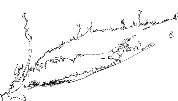
image showing the extent of the cst27 boundary for the Long Island Sound study area
Data_Set_Credit:
The National Oceanic and Atmospheric Administration (NOAA) compiled the original data set from which this subset was created, and Barbara Seekins for creating the data subset.
Native_Data_Set_Environment: ArcView 3.2 shapefile - lisound/data/chap04/cst27.shp

Data_Quality_Information:
Logical_Consistency_Report:
No additional checks for topological consistency were performed on this data set.
Completeness_Report: none
Lineage:
Source_Information:
Source_Citation:
Citation_Information:
Originator: National Oceanic and Atmospheric Administration
Publication_Date: Unknown
Publication_Time: Unknown
Title: NOAA's Medium Resolution Digital Vector Shoreline
Online_Linkage: <http://seaserver.nos.noaa.gov/projects/shoreline/shoreline.html>
Source_Scale_Denominator: 80000
Type_of_Source_Media: paper
Source_Time_Period_of_Content:
Time_Period_Information:
Single_Date/Time:
Calendar_Date: Unknown
Source_Currentness_Reference: Publication Date
Source_Citation_Abbreviation: EC80_04
Source_Contribution:
The specified section of NOAA's medium resolution shoreline was downloaded from their website. That file was clipped to include the are of interest for the Long Island Sound studies.
Process_Step:
Process_Description:
The file, EC80_04, was downloaded from the NOAA website. The downloaded Arc/Info 'gen' file was imported to Arc/Info to create a working coverage.
Source_Used_Citation_Abbreviation: EC80_04.e00
Process_Date: Unknown
Source_Produced_Citation_Abbreviation: ec80_04.aat
Process_Contact:
Contact_Information:
Contact_Person_Primary:
Contact_Person: Barbara Seekins
Contact_Organization: U. S. Geological Survey
Contact_Address:
Address_Type: mailing and physical address
Address: 384 Woods Hole Road
City: Woods Hole
State_or_Province: MA
Postal_Code: 02543-1598
Country: USA
Contact_Voice_Telephone: (508) 548-8700 x2259
Contact_Facsimile_Telephone: (508) 457-2310
Contact_Electronic_Mail_Address: bseekins@usgs.gov
Process_Step:
Process_Description:
The coastline information for the Long Island Sound study area was extracted from the previously created coverage and projected from geographic to the study area base projection of UTM.
Source_Used_Citation_Abbreviation: ec80_04.aat
Process_Date: Unknown
Source_Produced_Citation_Abbreviation: cst27cv.aat
Process_Contact:
Contact_Information:
Contact_Person_Primary:
Contact_Person: Barbara Seekins
Contact_Organization: U. S. Geological Survey
Contact_Address:
Address_Type: mailing and physical address
Address: 384 Woods Hole Road
City: Woods Hole
State_or_Province: MA
Postal_Code: 02543-1598
Country: USA
Contact_Voice_Telephone: (508) 548-8700 x2259
Contact_Facsimile_Telephone: (508) 457-2310
Contact_Electronic_Mail_Address: bseekins@usgs.gov
Process_Step:
Process_Description: The Arc coverage was converted to an ArcView shapefile.
Source_Used_Citation_Abbreviation: cst27cv.aat
Process_Date: Unknown
Source_Produced_Citation_Abbreviation: cst27.dbf
Source_Produced_Citation_Abbreviation: cst27.shp
Source_Produced_Citation_Abbreviation: cst27.shx
Process_Contact:
Contact_Information:
Contact_Person_Primary:
Contact_Person: Barbara Seekins
Contact_Organization: U. S. Geological Survey
Contact_Address:
Address_Type: mailing and physical address
Address: 384 Woods Hole Road
City: Woods Hole
State_or_Province: MA
Postal_Code: 02543-1598
Country: USA
Contact_Voice_Telephone: (508) 548-8700 x2259
Contact_Facsimile_Telephone: (508) 457-2310
Contact_Electronic_Mail_Address: bseekins@usgs.gov

Spatial_Data_Organization_Information:
Direct_Spatial_Reference_Method: Vector
Point_and_Vector_Object_Information:
SDTS_Terms_Description:
SDTS_Point_and_Vector_Object_Type: Complete chain
Point_and_Vector_Object_Count: 925

Spatial_Reference_Information:
Horizontal_Coordinate_System_Definition:
Planar:
Grid_Coordinate_System:
Grid_Coordinate_System_Name: Universal Transverse Mercator
Universal_Transverse_Mercator:
UTM_Zone_Number: 18
Transverse_Mercator:
Scale_Factor_at_Central_Meridian: 0.99960
Longitude_of_Central_Meridian: -075.000000
Latitude_of_Projection_Origin: +00.000000
False_Easting: 500000
False_Northing: 0
Planar_Coordinate_Information:
Planar_Coordinate_Encoding_Method: coordinate pair
Coordinate_Representation:
Abscissa_Resolution: 70
Ordinate_Resolution: 70
Planar_Distance_Units: Meters
Geodetic_Model:
Horizontal_Datum_Name: North American Datum of 1983
Ellipsoid_Name: WGS_1984
Semi-major_Axis: 6378137.00
Denominator_of_Flattening_Ratio: 0.003352810664747

Entity_and_Attribute_Information:
Detailed_Description:
Entity_Type:
Entity_Type_Label: cst27.dbf
Entity_Type_Definition: Shapefile attribute file
Entity_Type_Definition_Source: ESRI
Attribute:
Attribute_Label: Fnode_
Attribute_Definition:
From-node identifier of linear feature. This attribute is a carry over from the Arc/Info data file and has no relevance to the use of the data.
Attribute_Definition_Source: Software computed
Attribute_Domain_Values:
Range_Domain:
Range_Domain_Minimum: 2
Range_Domain_Maximum: 936
Attribute:
Attribute_Label: Tnode_
Attribute_Definition:
To-node identifier of linear feature. This attribute is a carry over from the Arc/Info data file and has no relevance to the use of the data.
Attribute_Definition_Source: Software computed
Attribute_Domain_Values:
Range_Domain:
Range_Domain_Minimum: 1
Range_Domain_Maximum: 935
Attribute:
Attribute_Label: Lpoly_
Attribute_Definition:
Internal number of polygon to left of arc. This is a carry over field from the Arc/Info coverage and has no relevance to the use of the dataset.
Attribute_Definition_Source: software computed
Attribute_Domain_Values:
Range_Domain:
Range_Domain_Minimum: 0
Range_Domain_Maximum: 0
Attribute:
Attribute_Label: Rpoly_
Attribute_Definition:
Internal number of polygon to right of arc. This is a carry over field from the Arc/Info coverage and has no relevance to the use of the dataset.
Attribute_Definition_Source: software computed
Attribute_Domain_Values:
Range_Domain:
Range_Domain_Minimum: 0
Range_Domain_Maximum: 0
Attribute:
Attribute_Label: Length
Attribute_Definition: Length of line
Attribute_Definition_Source: software computed
Attribute_Domain_Values:
Range_Domain:
Range_Domain_Minimum: 0.00000
Range_Domain_Maximum: 0.913
Attribute:
Attribute_Label: Cst27cv_
Attribute_Definition:
Carried over from the ArcInfo attribute CST27CV#. CST27CV# is an ArcInfo internal control parameter and has no applicable relevance to the use of the data.
Attribute_Definition_Source: software computed
Attribute_Domain_Values:
Range_Domain:
Range_Domain_Minimum: 1
Range_Domain_Maximum: 925
Attribute:
Attribute_Label: Cst27cv_id
Attribute_Definition:
Carried over from the ArcInfo attribute CST27CV-ID. CST27CV-ID is an ArcInfo internal control parameter and has no applicable relevance to the use of the data.
Attribute_Definition_Source: software computed
Attribute_Domain_Values:
Range_Domain:
Range_Domain_Minimum: 1
Range_Domain_Maximum: 927
Overview_Description:
Entity_and_Attribute_Overview:
NOAA's Medium Resolution Digital Vector Shoreline was compiled from hundreds of NOAA coast charts and comproses over 75,000 nautical miles of coastline. The portion contained here is part of the EC80_04 - Chincoteague Inlet Virginia to Block Island Sound Rhode Island data layer, which is part of the Atlantic East-Coast Section.
Entity_and_Attribute_Detail_Citation: <http://seaserver.nos.noaa.gov/projects/shoreline>

Distribution_Information:
Distributor:
Contact_Information:
Contact_Organization_Primary:
Contact_Organization: U. S. Geological Survey
Contact_Person: Larry Poppe
Contact_Address:
Address_Type: mailing and physical address
Address: 384 Woods Hole Road
City: Woods Hole
State_or_Province: MA
Postal_Code: 02543-1598
Country: USA
Contact_Voice_Telephone: (508)548-8700 x2314
Contact_Electronic_Mail_Address: lpoppe@usgs.gov
Resource_Description: Long Island Sound: cst27.shp
Distribution_Liability:
Although this derived data set and its lineage dataset have been used by the USGS, no warranty, expressed or implied, is made by the USGS as to the accuracy of the data and/or related materials. The act of distribution shall not constitute any such warranty, and no responsibility is assumed by the USGS in the use of these data or related materials.
 
Any potential users of this shapefile are reminded that this is a subset of a section from NOAA's medium resolution. For complete coverage or an unaltered dataset, the user should refer to NOAA's website identified in the source information section of this file.
Standard_Order_Process:
Digital_Form:
Digital_Transfer_Information:
Format_Name: ARCV
Format_Information_Content:
cst27.dbf
cst27.shp
cst27.shx
cst27.avl
cst27.sbn
cst27.sbx
File_Decompression_Technique: No compression applied
Transfer_Size: 1,078Kbytes
Digital_Transfer_Option:
Offline_Option:
Offline_Media: CD-ROM
Recording_Capacity:
Recording_Density: 650
Recording_Density_Units: Mbytes
Recording_Format: ISO 9600
Compatibility_Information:
The user must have a system with a CD-ROM capable of reading an ISO-9660 standard CD-ROM disk. To browse the information contained on this disk, the user must also have a current version of WWW browser available.
Digital_Form:
Digital_Transfer_Information:
Format_Name: ARCV
Format_Information_Content:
The six ArcView files (cst27.dbf, cst27.shp, cst27.shx, cst27.avl, cst27.sbn, cst27.sbx) comprising the distribution of surficial sediments in Long Island Sound.
File_Decompression_Technique: zip
Transfer_Size: 355Kbytes
Digital_Transfer_Option:
Offline_Option:
Offline_Media: CD-ROM
Recording_Capacity:
Recording_Density: 650
Recording_Density_Units: Mbytes
Recording_Format: ISO 9600
Compatibility_Information:
The user must have a system with a CD-ROM capable of reading an ISO-9660 standard CD-ROM disk. To browse the information contained on this disk, the user must also have a current version of WWW browser available. The user must also have the software installed on their computer system capable to unzip the archived file.
Fees: none

Metadata_Reference_Information:
Metadata_Date: 20000806
Metadata_Contact:
Contact_Information:
Contact_Person_Primary:
Contact_Person: Valerie Paskevich
Contact_Organization: U. S. Geological Survey
Contact_Position: computer specialist
Contact_Address:
Address_Type: mailing and physical address
Address: 384 Woods Hole Road
City: Woods Hole
State_or_Province: MA
Postal_Code: 02543-1598
Country: USA
Contact_Voice_Telephone: (508) 548-8700 x2281
Contact_Facsimile_Telephone: (508) 457-2310
Contact_Electronic_Mail_Address: vpaskevich@usgs.gov
Metadata_Standard_Name: FGDC Content Standards for Digital Geospatial Metadata
Metadata_Standard_Version: FGDC-STD-001-1998
Metadata_Time_Convention: Local time
Metadata_Access_Constraints: None
Metadata_Use_Constraints: None

Generated by mp version 2.5.3 on Sun Aug 06 18:05:18 2000