Title: Distribution of Total Organic Carbon (TOC) in Long Island
Sound
Publication_Information:
Publication_Place: Woods Hole Field Center, Woods Hole, MA
Publisher: U. S. Geological Survey
Larger_Work_Citation:
Citation_Information:
Originator: Valerie Paskevich(ed.)
Originator: Larry Poppe(ed.)
Publication_Date: 20001101
Publication_Time: Unknown
Title:
Georeferenced Sea-Floor Mapping and Bottom Photography in Long Island Sound
Series_Information:
Series_Name: U. S. Geological Survey Open-File Report
Issue_Identification: OFR 00-304
Publication_Information:
Publication_Place: Woods Hole Field Center, Woods Hole, MA
Publisher: U. S. Geological Survey
Description:
Abstract:
This GIS layer contains a polygon overlay showing the distribution of Total
Organic Carbon (TOC) in the sediments of Long Island Sound.
Purpose:
The purpose of this layer is to disseminate a digital version of the regional
total organic carbon distribution in LIS.
Time_Period_of_Content:
Time_Period_Information:
Range_of_Dates/Times:
Beginning_Date: 19920601
Ending_Date: 19980331
Currentness_Reference: Publication Date
Status:
Progress: Complete
Maintenance_and_Update_Frequency: None planned
Spatial_Domain:
Bounding_Coordinates:
West_Bounding_Coordinate: -74.1310
East_Bounding_Coordinate: -71.8412
North_Bounding_Coordinate: 41.4201
South_Bounding_Coordinate: 40.5037
Keywords:
Theme:
Theme_Keyword_Thesaurus: General
Theme_Keyword: U.S. Geological Survey
Theme_Keyword: USGS
Theme_Keyword: Coastal and Marine Geology Team
Theme_Keyword: Coastal and Marine Geology Program
Theme_Keyword: Woods Hole Field Center
Theme_Keyword: Connecticut Department of Environmental Protection
Theme_Keyword: ArcView
Theme_Keyword: arcview
Theme_Keyword: shapefile
Theme_Keyword: polygons
Theme_Keyword: Total Organic Carbon
Theme_Keyword: TOC
Theme_Keyword: surficial sediments
Theme_Keyword: grain-size analysis
Theme_Keyword: distribution of Total Organic Carbon
Place:
Place_Keyword_Thesaurus: General
Place_Keyword: Long Island Sound
Place_Keyword: Connecticut
Place_Keyword: New York
Access_Constraints: None
Use_Constraints:
The U.S. Geological Survey must be referenced as the originator of the
dataset in any future products or research derived from these data.
Although this derived data set and its lineage dataset have been used
by the USGS, no warranty, expressed or implied, is made by the USGS as
to the accuracy of the data and/or related materials. The act of distribution
shall not constitute any such warranty, and no responsibility is assumed
by the USGS in the use of these data or related materials.
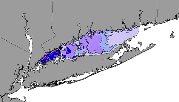
image showing the extent of the GIS layer and the distribution of Total
Organic Carbon (TOC) in surficial samples in Long Island Sound
Data_Set_Credit:
M. Moffett and Sarah Pratt, the analysts who performed the samples preparation.
Native_Data_Set_Environment:
ArcView version 3.2 shapefile format - lissound\data\chap05\listoc.shp
Cross_Reference:
Citation_Information:
Originator: L. J. Poppe(ed.)
Originator: H. J. Knebel
Originator: Z. J. Mlodzinska
Originator: M. E. Hastings
Originator: B. Seekins
Publication_Date: Unknown
Publication_Time: Unknown
Title:
The distribution of surficial sediment in Long Island Sound and adjacent
waters: texture and total organic carbon
Series_Information:
Series_Name: Journal of Coastal Research
Issue_Identification: in press
Publication_Information:
Publication_Place: Fort Lauderdale, FL
Publisher: Coastal Education and Research Foundation
Data_Quality_Information:
Attribute_Accuracy:
Attribute_Accuracy_Report:
Total organic carbon data are reproducible to less than 1 standard deviation.
Quantitative_Attribute_Accuracy_Assessment:
Attribute_Accuracy_Value: +/- 1 SD
Attribute_Accuracy_Explanation: All intrasample replicates fell
with 1 SD
Logical_Consistency_Report:
No additional checks for topological consistency were performed on this
data set.
Completeness_Report: none
Positional_Accuracy:
Horizontal_Positional_Accuracy:
Horizontal_Positional_Accuracy_Report:
Ship navigation was by differential GPS. Navigation fix accuracy is +/-10m,
typical accuracy for DGPS in LIS.
Vertical_Positional_Accuracy:
Vertical_Positional_Accuracy_Report:
Tidal range is less than 2m. No tidal corrections were performed.
Lineage:
Source_Information:
Source_Citation:
Citation_Information:
Originator: Poppe and others(comp.)
Publication_Date: 19980000
Publication_Time: Unknown
Title: Surficial Sediment database
Series_Information:
Series_Name: U.S. Geological Survey Open-File Report
Issue_Identification: 98-502
Publication_Information:
Publication_Place: Woods Hole Field Center
Publisher: U.S. Geological Survey
Type_of_Source_Media: CD-ROM
Source_Time_Period_of_Content:
Time_Period_Information:
Range_of_Dates/Times:
Beginning_Date: 19920601
Ending_Date: 19980331
Source_Currentness_Reference: Ground Condition
Source_Citation_Abbreviation: LISsamples
Source_Contribution:
These data, which represent the only regional total organic carbon study
of Long Island Sound, were originally published in USGS Open-File Report
98-502 .
Process_Step:
Process_Description:
Samples for TOC analysis were thawed, large shells and anumals were removed,
and the samples were homogenized. The samples were dried, ground, and vapor
acidified to remove the carbonates. Analyses were performed on a Perk and
Elmer 2400 CHN Analyzer.
Source_Used_Citation_Abbreviation: LISsamples
Process_Date: Unknown
Source_Produced_Citation_Abbreviation: LIS grain-size data
Process_Contact:
Contact_Information:
Contact_Organization_Primary:
Contact_Organization: U.S. Geological Survey
Contact_Person: Larry Poppe
Contact_Address:
Address_Type: mailing and physical address
Address: 384 Woods Hole road
City: Woods Hole
State_or_Province: MA
Postal_Code: 02543-1598
Country: USA
Contact_Voice_Telephone: (508) 548-8700 x2314
Contact_Electronic_Mail_Address: lpoppe@usgs.gov
Process_Step:
Process_Description:
TOC data from CHN analysis data points and values were plotted on paper
and hand contoured. The contour map was photographed and the resulting
photograph was scanned to create a TIF image file.
Source_Used_Citation_Abbreviation: LIS grain-size data
Process_Date: Unknown
Source_Produced_Citation_Abbreviation: listoc.tif
Process_Contact:
Contact_Information:
Contact_Organization_Primary:
Contact_Organization: U.S. Geological Survey
Contact_Person: Larry Poppe
Contact_Address:
Address_Type: mailing and physical address
Address: 384 Woods Hole road
City: Woods Hole
State_or_Province: MA
Postal_Code: 02543-1598
Country: USA
Contact_Voice_Telephone: (508) 548-8700 x2314
Contact_Electronic_Mail_Address: lpoppe@usgs.gov
Process_Step:
Process_Description:
The produced TIF image was brought into Arc/Info and georeferenced. The
georeferenced image was converted to an Arc/Info grid and projected to
UTM.
The grid file, listoc.grd, was displayed in ArcView and the TOC contours
were digitized on screen. The vectors were combined with a coastline file
to create a polygon shapefile.
Total Organic Carbon (TOC) in weight percent of dry sediment. Polygons
designated as land are land.
Data values are:
0.00 - 0.49
0.50 - 0.99
1.00 - 1.99
2.00 - 2.49
2.50 - 2.99
>3.00
land
no data
Attribute_Definition_Source: ranges are %TOC in weight % dry sediment
Attribute_Domain_Values:
Unrepresentable_Domain: Character field
Beginning_Date_of_Attribute_Values: 19960000
Ending_Date_of_Attribute_Values: 19980000
Attribute_Value_Accuracy_Information:
Attribute_Value_Accuracy: 1
Attribute_Value_Accuracy_Explanation:
All analytical replicates fell within 1 standard deviation of the other
values at that location
Attribute_Domain_Values:
Range_Domain:
Attribute_Units_of_Measure: Weight percent
Attribute_Measurement_Resolution: 0.01%
Overview_Description:
Entity_and_Attribute_Overview:
This data layer (the distribution of total organic carbon) is a polygon layer showing the regional variations in the concentrations of total
organic carbon in the surficial sediment of Long Island Sound. The data
attribute (Ztoc) is in weight percent of dry sediment.
Entity_and_Attribute_Detail_Citation:
Distribution of surficial sediment in Long Island Sound and adjacent waters:
texture and total organic carbon, by Poppe and others
Distribution_Information:
Distributor:
Contact_Information:
Contact_Organization_Primary:
Contact_Organization: U. S. Geological Survey
Contact_Person: Larry Poppe
Contact_Address:
Address_Type: mailing and physical address
Address: 384 Woods Hole Road
City: Woods Hole
State_or_Province: MA
Postal_Code: 02543-1598
Country: USA
Contact_Voice_Telephone: (508)548-8700 x2314
Contact_Electronic_Mail_Address: lpoppe@usgs.gov
Resource_Description: Long Island Sound: listoc.shp
Distribution_Liability:
Although this derived data set and its lineage dataset have been used
by the USGS, no warranty, expressed or implied, is made by the USGS as
to the accuracy of the data and/or related materials. The act of distribution
shall not constitute any such warranty, and no responsibility is assumed
by the USGS in the use of these data or related materials.
Standard_Order_Process:
Digital_Form:
Digital_Transfer_Information:
Format_Name: ARCV
Format_Information_Content:
listoc.dbf
listoc.shp
listoc.shx
listoc.avl
listoc.sbn
listoc.sbx
File_Decompression_Technique: No compression applied
Transfer_Size: 1,324Kbytes
Digital_Transfer_Option:
Offline_Option:
Offline_Media: CD-ROM
Recording_Capacity:
Recording_Density: 650
Recording_Density_Units: Mbytes
Recording_Format: ISO 9600
Compatibility_Information:
The user must have a system with a CD-ROM capable of reading an ISO-9660
standard CD-ROM disk. To browse the information contained on this disk,
the user must also have a current version of WWW browser available.
Digital_Form:
Digital_Transfer_Information:
Format_Name: ARCV
Format_Information_Content:
The six ArcView files (listoc.dbf, listoc.shp, listoc.shx, listoc.avl,
listoc.sbn, listoc.sbx) comprising the distribution of surficial sediments
in Long Island Sound.
File_Decompression_Technique: zip
Transfer_Size: 659Kbytes
Digital_Transfer_Option:
Offline_Option:
Offline_Media: CD-ROM
Recording_Capacity:
Recording_Density: 650
Recording_Density_Units: Mbytes
Recording_Format: ISO 9600
Compatibility_Information:
The user must have a system with a CD-ROM capable of reading an ISO-9660
standard CD-ROM disk. To browse the information contained on this disk,
the user must also have a current version of WWW browser available. The
user must also have the software installed on their computer system capable
to unzip the archived file.
Fees: none
Technical_Prerequisites:
The listoc overlay is available in an ArcView shapefile format. The user
must have ESRI's ArcView 3.0 or greater software to read and process the
data file. In lieu of Arcview, the user may utilize another GIS application
package capable of importing the data.