Title: Long Island Sound metals sample distribution locations
Publication_Information:
Publication_Place: Woods Hole Field Center, Woods Hole, MA
Publisher: U.S. Geological Survey
Larger_Work_Citation:
Citation_Information:
Originator: Valerie Paskevich(ed.)
Originator: Larry Poppe(ed.)
Publication_Date: Unknown
Publication_Time: Unknown
Title:
Georeferenced Sea-Floor Mapping and Bottom Photography in Long Island Sound
Series_Information:
Series_Name: U. S. Geological Survey Open-File Report
Issue_Identification: OFR 00-304
Publication_Information:
Publication_Place: Woods Hole Field Center, Woods Hole, MA
Publisher: U. S. Geological Survey
Description:
Abstract:
This GIS layer contains a point overlay showing the location of surficial
samples used in the analysis of metal distributions in LIS. Attribute information
containing the chemical analysis values are also included in the data layer.
Purpose:
The purpose of this datalayer is to disseminate a digital version of the
map showing the locations of surficial samples used in the analysis of
metal distributions in LIS.
Time_Period_of_Content:
Time_Period_Information:
Multiple_Dates/Times:
Single_Date/Time:
Calendar_Date: 19960000
Single_Date/Time:
Calendar_Date: 19970000
Currentness_Reference: sample collection
Status:
Progress: Complete
Maintenance_and_Update_Frequency: None planned
Spatial_Domain:
Bounding_Coordinates:
West_Bounding_Coordinate: -73.7469
East_Bounding_Coordinate: -72.0420
North_Bounding_Coordinate: 41.3379
South_Bounding_Coordinate: 40.8363
Keywords:
Theme:
Theme_Keyword_Thesaurus: General
Theme_Keyword: U.S. Geological Survey
Theme_Keyword: USGS
Theme_Keyword: Coastal and Marine Geology Team
Theme_Keyword: Coastal and Marine Geology Program
Theme_Keyword: Woods Hole Field Center
Theme_Keyword: Connecticut Department of Environmental Protection
Theme_Keyword: ArcView
Theme_Keyword: arcview
Theme_Keyword: shapefile
Theme_Keyword: points
Theme_Keyword: surficial sediments
Theme_Keyword: metal distribution
Theme_Keyword: Ag
Theme_Keyword: silver
Theme_Keyword: Al
Theme_Keyword: aluminum
Theme_Keyword: Ba
Theme_Keyword: barium
Theme_Keyword: Ca
Theme_Keyword: calcium
Theme_Keyword: Cd
Theme_Keyword: cadmium
Theme_Keyword: Cr
Theme_Keyword: chromium
Theme_Keyword: Cu
Theme_Keyword: copper
Theme_Keyword: Fe
Theme_Keyword: iron
Theme_Keyword: Hg
Theme_Keyword: mercury
Theme_Keyword: Mn
Theme_Keyword: manganese
Theme_Keyword: Ni
Theme_Keyword: nickel
Theme_Keyword: Pb
Theme_Keyword: lead
Theme_Keyword: Ti
Theme_Keyword: titanium
Theme_Keyword: V
Theme_Keyword: vanadium
Theme_Keyword: Zn
Theme_Keyword: zinc
Theme_Keyword: Zr
Theme_Keyword: zirconium
Theme_Keyword: sedimentary environment
Place:
Place_Keyword_Thesaurus: General
Place_Keyword: Long Island Sound
Place_Keyword: Connecticut
Place_Keyword: New York
Access_Constraints: None
Use_Constraints:
The U.S. Geological Survey must be referenced as the originator of the
dataset in any future products or research derived from these data.
Although this derived data set and its lineage dataset have been used
by the USGS, no warranty, expressed or implied, is made by the USGS as
to the accuracy of the data and/or related materials. The act of distribution
shall not constitute any such warranty, and no responsibility is assumed
by the USGS in the use of these data or related materials.
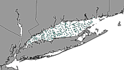
image showing the extent of the GIS layer and the distribution of Long
Island Sound samples used in the LIS metals calculations
Native_Data_Set_Environment:
ArcView version 3.2 shapefile format - lissound\data\chap06\lisgrabs.shp
Cross_Reference:
Citation_Information:
Originator: Ellen L. Mecray(ed.)
Originator: Marilyn R. Bucholtz ten Brink
Originator: Sunita Shah
Publication_Date: Unknown
Publication_Time: Unknown
Title:
Metal Distribution in the Surface Sediments of Long Island Sound
Series_Information:
Series_Name: Journal of Coastal Research
Issue_Identification: in press
Data_Quality_Information:
Attribute_Accuracy:
Attribute_Accuracy_Report:
Navigation for sample stations was done with differential GPS. Accuracy
is assumed to be +/-10m.
Quantitative_Attribute_Accuracy_Assessment:
Attribute_Accuracy_Value: +/-10 m
Attribute_Accuracy_Explanation: Typical accuracy for DGPS
Logical_Consistency_Report:
No additional checks for topological consistency were performed on this
data set.
Completeness_Report: none
Positional_Accuracy:
Horizontal_Positional_Accuracy:
Horizontal_Positional_Accuracy_Report:
Navigation was by Differential GPS, which is accurate to less than 10 m.
Typical accuracy for differential GPS navigation.
Vertical_Positional_Accuracy:
Vertical_Positional_Accuracy_Report:
Vertical accuracy is +/-2m. Tidal range in LIS is less than 2 m
Lineage:
Source_Information:
Source_Citation:
Citation_Information:
Originator:
various sampling cruises (primarily SEAX96017, SEAX96024, and JD9801)
Publication_Date: Unknown
Publication_Time: Unknown
Title:
surface sediments collected during the time period of 1996 - 1997 in Long
Island Sound by the USGS
Type_of_Source_Media: surficial samples
Source_Time_Period_of_Content:
Time_Period_Information:
Multiple_Dates/Times:
Single_Date/Time:
Calendar_Date: 19960000
Single_Date/Time:
Calendar_Date: 19970000
Source_Currentness_Reference: Publication Date
Source_Citation_Abbreviation: LISgrabs
Source_Contribution:
samples were analyzed in the laboratory to calculate metals contents
Process_Step:
Process_Description:
Samples were frozen in the field, and freeze dried in the laboratory. Freeze-dried
samples were divided for various analyses. The metals data were generated
on an ICP-AES at Boston University after total acid disestion. Data (consisting
of the sample station navigation in decimal degrees and metals concentrations)
were imported as a text file.
Lisgrabs5_ is an internal parameter assigned by MapInfo during the export
of the data layer and has no relevance to the use of the data.
Attribute_Definition_Source: User Defined
Attribute_Domain_Values:
Range_Domain:
Range_Domain_Minimum: 1
Range_Domain_Maximum: 254
Attribute:
Attribute_Label: Cruise
Attribute_Definition:
Name or number of cruise on which sample was collected.
Attribute_Definition_Source: User Defined
Attribute_Domain_Values:
Unrepresentable_Domain: Character field
Attribute:
Attribute_Label: Station_na
Attribute_Definition: Name or number of station at which sample
was collected.
Attribute_Definition_Source: User Defined
Attribute_Domain_Values:
Unrepresentable_Domain: Character field
Attribute:
Attribute_Label: Longitude_
Attribute_Definition:
Longitude in decimal degrees. West longitude is recorded as negative values.
Attribute_Definition_Source: User Defined
Attribute_Domain_Values:
Range_Domain:
Range_Domain_Minimum: -73.746600
Range_Domain_Maximum: -72.043400
Attribute_Units_of_Measure: decimal degrees
Attribute:
Attribute_Label: Latitude__
Attribute_Definition:
Latitude in decimal degrees. South latitude is recorded as negative values.
Attribute_Definition_Source: User Defined
Attribute_Domain_Values:
Range_Domain:
Range_Domain_Minimum: 40.866000
Range_Domain_Maximum: 41.310300
Attribute_Units_of_Measure: decimal degrees
Attribute:
Attribute_Label: Year_sampl
Attribute_Definition: Year sample was collected from the natural
environment.
Attribute_Definition_Source: User Defined
Attribute_Domain_Values:
Range_Domain:
Range_Domain_Minimum: 1996
Range_Domain_Maximum: 1999
Attribute_Units_of_Measure: Julian day
Attribute:
Attribute_Label: Date_sampl
Attribute_Definition:
Date when sample was collected from the natural environment. Recorded by
Julian day. (Date sample collected)
Attribute_Definition_Source: User Defined
Attribute_Domain_Values:
Range_Domain:
Range_Domain_Minimum: 0
Range_Domain_Maximum: 314
Attribute:
Attribute_Label: Time__gmt_
Attribute_Definition:
Hour and minutes when the sample was collected from the natural environment.
(Time sample collected)
Attribute_Definition_Source: User Defined
Attribute_Domain_Values:
Unrepresentable_Domain: Character field
Attribute_Domain_Values:
Range_Domain:
Attribute_Units_of_Measure: GMT
Attribute:
Attribute_Label: Water_dept
Attribute_Definition:
Measured depth of water overlying sediment at sample time, in original
units. (Water depth at site not corrected for tides.)
Attribute_Definition_Source: User Defined
Attribute_Domain_Values:
Range_Domain:
Range_Domain_Minimum: 0.000000
Range_Domain_Maximum: 52.000000
Attribute_Units_of_Measure: meters
Attribute:
Attribute_Label: Sample_int
Attribute_Definition: The depth of the sample in the sediment.
Attribute_Definition_Source: User Defined
Attribute_Domain_Values:
Enumerated_Domain:
Enumerated_Domain_Value: 0-2 cm
Enumerated_Domain_Value_Definition: 0-2 cm below the sediment-water
interface
Enumerated_Domain_Value_Definition_Source: User Defined
Unrepresentable_Domain: Character field
Attribute_Domain_Values:
Range_Domain:
Attribute_Units_of_Measure: centimeters
Attribute:
Attribute_Label: Z_fines
Attribute_Definition:
The percent fines (i.e. silt plus clay sized material) in the sample
Attribute_Definition_Source: User Defined
Attribute_Domain_Values:
Range_Domain:
Range_Domain_Minimum: 0.000000
Range_Domain_Maximum: 98.930000
Attribute_Units_of_Measure: percent
Attribute:
Attribute_Label: Verbal_equ
Attribute_Definition:
Text description of the non-biological part of the sediment
Attribute_Definition_Source: User Defined
Attribute_Domain_Values:
Unrepresentable_Domain: Character field
Attribute:
Attribute_Label: Ag__silver
Attribute_Definition:
Concentration of Silver (Ag) in sample
Attribute_Definition_Source: User Defined
Attribute_Domain_Values:
Range_Domain:
Range_Domain_Minimum: 0.000000
Range_Domain_Maximum: 2.567800
Attribute_Units_of_Measure: micrograms per gram
Attribute:
Attribute_Label: Ag_qualifi
Attribute_Definition:
Any qualifier information or comments about the Silver concentrations;
e.g. "less than" (< or 1t); analytical trouble with this sample; corrections
made; indications of poor quality data; etc.
Attribute_Definition_Source: User Defined
Attribute_Domain_Values:
Unrepresentable_Domain: Character field
Attribute:
Attribute_Label: Ag_dl
Attribute_Definition:
The lowest detectable concentration of Silver for this Lab and this methodology
Attribute_Definition_Source: User Defined
Attribute_Domain_Values:
Range_Domain:
Range_Domain_Minimum: 0.000000
Range_Domain_Maximum: 0.130000
Attribute:
Attribute_Label: Al__alumin
Attribute_Definition:
Concentration of Aluminium (Al) in sample
Attribute_Definition_Source: User Defined
Attribute_Domain_Values:
Range_Domain:
Range_Domain_Minimum: 0.000000
Range_Domain_Maximum: 0.074000
Attribute_Units_of_Measure: weight percent
Attribute:
Attribute_Label: Al_qualifi
Attribute_Definition:
Any qualifier information or comments about the Aluminum concentrations;
e.g. "less than" (< or 1t); analytical trouble with this sample; corrections
made; indications of poor quality data; etc.
Attribute_Definition_Source: User Defined
Attribute_Domain_Values:
Unrepresentable_Domain: Character field
Attribute:
Attribute_Label: Al_dl
Attribute_Definition:
The lowest detectable concentration of Aluminum for this Lab and this methodology
Attribute_Definition_Source: User Defined
Attribute_Domain_Values:
Range_Domain:
Range_Domain_Minimum: 0.000000
Range_Domain_Maximum: 0.020000
Attribute:
Attribute_Label: Ba__barium
Attribute_Definition:
Concentration of Barium (Ba) in sample
Attribute_Definition_Source: User Defined
Attribute_Domain_Values:
Range_Domain:
Range_Domain_Minimum: 0.000000
Range_Domain_Maximum: 1180.460000
Attribute_Units_of_Measure: micrograms per gram
Attribute:
Attribute_Label: Ba_qualifi
Attribute_Definition:
Any qualifier information or comments about the Barium concentrations;
e.g. "less than" (< or 1t); analytical trouble with this sample; corrections
made; indications of poor quality data; etc.
Attribute_Definition_Source: User Defined
Attribute_Domain_Values:
Unrepresentable_Domain: Character field
Attribute:
Attribute_Label: Ba_dl
Attribute_Definition:
The lowest detectable concentration of Barium for this Lab and this methodology
Attribute_Definition_Source: User Defined
Attribute_Domain_Values:
Range_Domain:
Range_Domain_Minimum: 0.000000
Range_Domain_Maximum: 2.000000
Attribute:
Attribute_Label: Ca__calciu
Attribute_Definition:
Concentration of Calcium (Ca) in sample
Attribute_Definition_Source: User Defined
Attribute_Domain_Values:
Range_Domain:
Range_Domain_Minimum: 0.000000
Range_Domain_Maximum: 5.355730
Attribute_Units_of_Measure: weight percent
Attribute:
Attribute_Label: Ca_qualifi
Attribute_Definition:
Any qualifier information or comments about the Calcium concentrations;
e.g. "less than" (< or 1t); analytical trouble with this sample; corrections
made; indications of poor quality data; etc.
Attribute_Definition_Source: User Defined
Attribute_Domain_Values:
Unrepresentable_Domain: Character field
Attribute:
Attribute_Label: Ca_dl
Attribute_Definition:
The lowest detectable concentration of Calcium for this Lab and this methodology
Attribute_Definition_Source: User Defined
Attribute_Domain_Values:
Unrepresentable_Domain: Character field
Attribute:
Attribute_Label: Cd__cadmiu
Attribute_Definition:
Concentration of Cadmium (Cd) in sample
Attribute_Definition_Source: User Defined
Attribute_Domain_Values:
Range_Domain:
Range_Domain_Minimum: 0.000000
Range_Domain_Maximum: 1.940000
Attribute_Units_of_Measure: micrograms per gram
Attribute:
Attribute_Label: Cd_qualifi
Attribute_Definition:
Any qualifier information or comments about the Cadmium concentrations;
e.g. "less than" (< or 1t); analytical trouble with this sample; corrections
made; indications of poor quality data; etc.
Attribute_Definition_Source: User Defined
Attribute_Domain_Values:
Unrepresentable_Domain: Character field
Attribute:
Attribute_Label: Cd_dl
Attribute_Definition:
The lowest detectable concentration of Cadmium for this Lab and this methodology
Attribute_Definition_Source: User Defined
Attribute_Domain_Values:
Range_Domain:
Range_Domain_Minimum: 0.000000
Range_Domain_Maximum: 0.100000
Attribute:
Attribute_Label: Cr__chromi
Attribute_Definition:
Concentration of Chromium (Cr) in sample
Attribute_Definition_Source: User Defined
Attribute_Domain_Values:
Range_Domain:
Range_Domain_Minimum: 0.000000
Range_Domain_Maximum: 230.923000
Attribute_Units_of_Measure: micrograms per gram
Attribute:
Attribute_Label: Cr_qualifi
Attribute_Definition:
Any qualifier information or comments about the Chromium concentrations;
e.g. "less than" (< or 1t); analytical trouble with this sample; corrections
made; indications of poor quality data; etc.
Attribute_Definition_Source: User Defined
Attribute_Domain_Values:
Unrepresentable_Domain: Character field
Attribute:
Attribute_Label: Cr_dl
Attribute_Definition:
The lowest detectable concentration of Chromium for this Lab and this methodology
Attribute_Definition_Source: User Defined
Attribute_Domain_Values:
Range_Domain:
Range_Domain_Minimum: 0.000000
Range_Domain_Maximum: 6.000000
Attribute:
Attribute_Label: Cu__copper
Attribute_Definition:
Concentration of Copper (Cu) in sample
Attribute_Definition_Source: User Defined
Attribute_Domain_Values:
Range_Domain:
Range_Domain_Minimum: 0.000000
Range_Domain_Maximum: 275.000000
Attribute_Units_of_Measure: micrograms per gram
Attribute:
Attribute_Label: Cu_qualifi
Attribute_Definition:
Any qualifier information or comments about the Copper concentrations;
e.g. "less than" (< or 1t); analytical trouble with this sample; corrections
made; indications of poor quality data; etc.
Attribute_Definition_Source: User Defined
Attribute_Domain_Values:
Unrepresentable_Domain: Character field
Attribute:
Attribute_Label: Cu_dl
Attribute_Definition:
The lowest detectable concentration of Copper for this Lab and this methodology
Attribute_Definition_Source: User Defined
Attribute_Domain_Values:
Range_Domain:
Range_Domain_Minimum: 0.000000
Range_Domain_Maximum: 20.000000
Attribute:
Attribute_Label: Fe__iron__
Attribute_Definition:
Concentration of Iron (Fe) in sample
Attribute_Definition_Source: User Defined
Attribute_Domain_Values:
Range_Domain:
Range_Domain_Minimum: 0.000000
Range_Domain_Maximum: 9.429460
Attribute_Units_of_Measure: weight percent
Attribute:
Attribute_Label: Fe_qualifi
Attribute_Definition:
Any qualifier information or comments about the Iron concentrations; e.g.
"less than" (< or 1t); analytical trouble with this sample; corrections
made; indications of poor quality data; etc.
Attribute_Definition_Source: User Defined
Attribute_Domain_Values:
Unrepresentable_Domain: Character field
Attribute:
Attribute_Label: Fe_dl
Attribute_Definition:
The lowest detectable concentration of Iron for this Lab and this methodology
Attribute_Definition_Source: User Defined
Attribute_Domain_Values:
Range_Domain:
Range_Domain_Minimum: 0.000000
Range_Domain_Maximum: 1.000000
Attribute:
Attribute_Label: Hg__mercur
Attribute_Definition:
Concentration of Mercury (Hg) in sample
Attribute_Definition_Source: User Defined
Attribute_Domain_Values:
Range_Domain:
Range_Domain_Minimum: 0.000000
Range_Domain_Maximum: 635.000000
Attribute_Units_of_Measure: micrograms per gram
Attribute:
Attribute_Label: Hg_qualifi
Attribute_Definition:
Any qualifier information or comments about the Mercury concentrations;
e.g. "less than" (< or 1t); analytical trouble with this sample; corrections
made; indications of poor quality data; etc.
Attribute_Definition_Source: User Defined
Attribute_Domain_Values:
Unrepresentable_Domain: Character field
Attribute:
Attribute_Label: Mn__mangan
Attribute_Definition:
Concentration of Manganese (Mg) in sample
Attribute_Definition_Source: User Defined
Attribute_Domain_Values:
Range_Domain:
Range_Domain_Minimum: 0.000000
Range_Domain_Maximum: 4626.760000
Attribute_Units_of_Measure: micrograms per gram
Attribute:
Attribute_Label: Mn_qualifi
Attribute_Definition:
Any qualifier information or comments about the Manganese concentrations;
e.g. "less than" (< or 1t); analytical trouble with this sample; corrections
made; indications of poor quality data; etc.
Attribute_Definition_Source: User Defined
Attribute_Domain_Values:
Unrepresentable_Domain: Character field
Attribute:
Attribute_Label: Ni__nickel
Attribute_Definition:
Concentration of Nickel (Ni) in sample
Attribute_Definition_Source: User Defined
Attribute_Domain_Values:
Range_Domain:
Range_Domain_Minimum: 0.000000
Range_Domain_Maximum: 212.164000
Attribute_Units_of_Measure: micrograms per gram
Attribute:
Attribute_Label: Ni_qualifi
Attribute_Definition:
Any qualifier information or comments about the Nickel concentrations;
e.g. "less than" (< or 1t); analytical trouble with this sample; corrections
made; indications of poor quality data; etc.
Attribute_Definition_Source: User Defined
Attribute_Domain_Values:
Unrepresentable_Domain: Character field
Attribute:
Attribute_Label: Ni_dl
Attribute_Definition:
The lowest detectable concentration of Nickel for this Lab and this methodology
Attribute_Definition_Source: User Defined
Attribute_Domain_Values:
Range_Domain:
Range_Domain_Minimum: 0.000000
Range_Domain_Maximum: 10.000000
Attribute:
Attribute_Label: Pb__lead__
Attribute_Definition:
Concentration of Lead (Pb) in sample
Attribute_Definition_Source: User Defined
Attribute_Domain_Values:
Range_Domain:
Range_Domain_Minimum: 0.000000
Range_Domain_Maximum: 147.201000
Attribute_Units_of_Measure: micrograms per gram
Attribute:
Attribute_Label: Pb_qualifi
Attribute_Definition:
Any qualifier information or comments about the Lead concentrations; e.g.
"less than" (< or 1t); analytical trouble with this sample; corrections
made; indications of poor quality data; etc.
Attribute_Definition_Source: User Defined
Attribute_Domain_Values:
Unrepresentable_Domain: Character field
Attribute:
Attribute_Label: Ti__titani
Attribute_Definition:
Concentration of Titanium (Ti) in sample
Attribute_Definition_Source: User Defined
Attribute_Domain_Values:
Range_Domain:
Range_Domain_Minimum: 0.000000
Range_Domain_Maximum: 1.656460
Attribute_Units_of_Measure: weight percent
Attribute:
Attribute_Label: Ti_qualifi
Attribute_Definition:
Any qualifier information or comments about the Titanium concentrations;
e.g. "less than" (< or 1t); analytical trouble with this sample; corrections
made; indications of poor quality data; etc.
Attribute_Definition_Source: User Defined
Attribute_Domain_Values:
Unrepresentable_Domain: Character field
Attribute:
Attribute_Label: V_________
Attribute_Definition:
Concentration of Vanadium (V) in sample
Attribute_Definition_Source: User Defined
Attribute_Domain_Values:
Range_Domain:
Range_Domain_Minimum: 0.000000
Range_Domain_Maximum: 128.668000
Attribute_Units_of_Measure: micrograms per gram
Attribute:
Attribute_Label: V_qualifi
Attribute_Definition:
Any qualifier information or comments about the Vanadium concentrations;
e.g. "less than" (< or 1t); analytical trouble with this sample; corrections
made; indications of poor quality data; etc.
Attribute_Definition_Source: User Defined
Attribute_Domain_Values:
Unrepresentable_Domain: Character field
Attribute:
Attribute_Label: V_dl
Attribute_Definition:
The lowest detectable concentration of Vanadium for this Lab and this methodology
Attribute_Definition_Source: User Defined
Attribute_Domain_Values:
Range_Domain:
Range_Domain_Minimum: 0.000000
Range_Domain_Maximum: 4.000000
Attribute:
Attribute_Label: Zn________
Attribute_Definition:
Concentration of Zinc (Zn) in sample
Attribute_Definition_Source: User Defined
Attribute_Domain_Values:
Range_Domain:
Range_Domain_Minimum: 0.000000
Range_Domain_Maximum: 293.700000
Attribute_Units_of_Measure: micrograms per gram
Attribute:
Attribute_Label: Zn_qualifi
Attribute_Definition:
Any qualifier information or comments about the Zinc concentrations; e.g.
"less than" (< or 1t); analytical trouble with this sample; corrections
made; indications of poor quality data; etc.
Attribute_Definition_Source: User Defined
Attribute_Domain_Values:
Unrepresentable_Domain: Character field
Attribute:
Attribute_Label: Zn_dl
Attribute_Definition:
The lowest detectable concentration of Zinc for this Lab and this methodology
Attribute_Definition_Source: User Defined
Attribute_Domain_Values:
Range_Domain:
Range_Domain_Minimum: 0.000000
Range_Domain_Maximum: 12.000000
Attribute:
Attribute_Label: Zr__zircon
Attribute_Definition:
Concentration of Zirconium (Zr) in sample
Attribute_Definition_Source: User Defined
Attribute_Domain_Values:
Range_Domain:
Range_Domain_Minimum: 0.000000
Range_Domain_Maximum: 1145.380000
Attribute_Units_of_Measure: micrograms per gram
Attribute:
Attribute_Label: Zr_qualifi
Attribute_Definition:
Any qualifier information or comments about the Zirconium concentrations;
e.g. "less than" (< or 1t); analytical trouble with this sample; corrections
made; indications of poor quality data; etc.
Attribute_Definition_Source: User Defined
Attribute_Domain_Values:
Unrepresentable_Domain: Character field
Attribute:
Attribute_Label: Comments__
Attribute_Definition: Any comments about the metals concentrations.
Attribute_Definition_Source: User Defined
Attribute_Domain_Values:
Unrepresentable_Domain: Character field
Overview_Description:
Entity_and_Attribute_Overview:
This is a point layer showing the regional distribution of
metals in the surface sediments of LIS
Entity_and_Attribute_Detail_Citation: Mecray and others, 2000
Distribution_Information:
Distributor:
Contact_Information:
Contact_Organization_Primary:
Contact_Organization: U.S. Geological Survey
Contact_Person: Ellen L. Mecray
Contact_Address:
Address_Type: mailing and physical address
Address: 384 Woods Hole Road
City: Woods Hole
State_or_Province: MA
Postal_Code: 02543-1598
Country: USA
Contact_Voice_Telephone: (508) 548-8700
Contact_Electronic_Mail_Address: emecray@usgs.gov
Resource_Description: Long Island Sound: lisgrabs.shp
Distribution_Liability:
Although this derived data set and its lineage dataset have been used
by the USGS, no warranty, expressed or implied, is made by the USGS as
to the accuracy of the data and/or related materials. The act of distribution
shall not constitute any such warranty, and no responsibility is assumed
by the USGS in the use of these data or related materials.
Standard_Order_Process:
Digital_Form:
Digital_Transfer_Information:
Format_Name: ARCV
Format_Information_Content:
lisgrabs.dbf
lisgrabs.shp
lisgrabs.shx
lisgrabs.avl
lisgrabs.sbn
lisgrabs.sbx
File_Decompression_Technique: No compression applied
Transfer_Size: 247Kbytes
Digital_Transfer_Option:
Offline_Option:
Offline_Media: CD-ROM
Recording_Capacity:
Recording_Density: 650
Recording_Density_Units: Mbytes
Recording_Format: ISO 9600
Compatibility_Information:
The user must have a system with a CD-ROM capable of reading an ISO-9660
standard CD-ROM disk. To browse the information contained on this disk,
the user must also have a current version of WWW browser available.
Digital_Form:
Digital_Transfer_Information:
Format_Name: ARCV
Format_Information_Content:
The six ArcView files (lisgrabs.dbf, lisgrabs.shp, lisgrabs.shx, lisgrabs.avl,
lisgrabs.sbn, lisgrabs.sbx) comprising a GIS layer showing the distribution
of the samples used to compute metal distribution in LIS.
File_Decompression_Technique: zip
Transfer_Size: 41Kbytes
Digital_Transfer_Option:
Offline_Option:
Offline_Media: CD-ROM
Recording_Capacity:
Recording_Density: 650
Recording_Density_Units: Mbytes
Recording_Format: ISO 9600
Compatibility_Information:
The user must have a system with a CD-ROM capable of reading an ISO-9660
standard CD-ROM disk. To browse the information contained on this disk,
the user must also have a current version of WWW browser available. The
user must also have the software installed on their computer system capable
to unzip the archived file.
Fees: none
Custom_Order_Process: Not available
Technical_Prerequisites:
The lisgrabs layer is available in an ArcView shapefile format. The user
must have ESRI's ArcView 3.0 or greater software to read and process the
data file. In lieu of Arcview, the user may utilize another GIS application
package capable of importing the data.