detailed analysis of 35 most common species found in Long Island Sound benthic communities

Metadata:


Identification_Information:
Citation:
Citation_Information:
Originator: Roman N. Zajac(comp.)
Publication_Date: 20000000
Title:
detailed analysis of 35 most common species found in Long Island Sound benthic communities
Publication_Information:
Publication_Place: Woods Hole Field Center
Publisher: U.S. Geological Survey
Larger_Work_Citation:
Citation_Information:
Originator: Valerie Paskevich(ed.)
Originator: Larry Poppe(ed.)
Publication_Date: 20000000
Title:
Georeferenced sea-floor mapping and bottom photography in Long Island Sound
Series_Information:
Series_Name: U.S. Geological Survey Open-File report
Issue_Identification: 00-304
Publication_Information:
Publication_Place: Woods Hole Field Center
Publisher: U.S. Geological Survey
Description:
Abstract:
This GIS layer provides the location where samples from Pellegrino and Hubbard were summarized to provide detailed analysis of 35 common species found in Long Island Sound benthic communities
Purpose:
This GIS layer, which focuses on benthic communities, was developed as part of a cooperative project between the University of New Haven, the Connecticut DEP, and the U.S. Geological Survey. Benthic communities are an integral component of the ecology of LIS.
 
Understanding the role that spatial heterogeneity plays in the dynamic of benthic landscapes may be a key to developing a better understanding of the estuarine ecology and the impacts of huuman activity. The purpose of providing this data layer is to help establish a regional framework for developing a more extensive GIS for benthic communities in LIS that can be used for education, research, and environmental management.
Time_Period_of_Content:
Time_Period_Information:
Single_Date/Time:
Calendar_Date: 19830000
Currentness_Reference: Publication Date
Status:
Progress: Complete
Maintenance_and_Update_Frequency: None planned
Spatial_Domain:
Bounding_Coordinates:
West_Bounding_Coordinate: -73.6418
East_Bounding_Coordinate: -71.8630
North_Bounding_Coordinate: 41.3536
South_Bounding_Coordinate: 40.9067
Keywords:
Theme:
Theme_Keyword_Thesaurus: General
Theme_Keyword: U. S. Geological Survey
Theme_Keyword: USGS
Theme_Keyword: Coastal and Marine Geology Team
Theme_Keyword: Coastal and Marine Geology Program
Theme_Keyword: Woods Hole Field Center
Theme_Keyword: Connecticut Department of Environmental Protection
Theme_Keyword: University of New Haven
Theme_Keyword: ArcView
Theme_Keyword: arcview
Theme_Keyword: shapefile
Theme_Keyword: points
Theme_Keyword: Pellegrino
Theme_Keyword: Hubbard
Theme_Keyword: biology
Theme_Keyword: communities
Theme_Keyword: infauna
Theme_Keyword: shellfish
Theme_Keyword: assessment
Theme_Keyword: environmental impacts
Place:
Place_Keyword_Thesaurus: General
Place_Keyword: Long Island Sound
Place_Keyword: estuary
Place_Keyword: Connecticut
Place_Keyword: New York
Access_Constraints:
The University of New Haven and the U.S. Geological Survey must be referenced as the originator of the data set in any future products or as research derived from these data.
 
Although this derived data set and its lineage dataset have been used by the University of New Haven and the USGS, no warranty, expressed or implied, is made by the University of New Haven or the USGS as to the accuracy of the data and/or related materials. The act of distribution shall not constitute any such warranty, and no responsibility is assumed by the University of New Haven or the USGS in the use of the data or related materials.
Use_Constraints: None
Point_of_Contact:
Contact_Information:
Contact_Person_Primary:
Contact_Person: Roman Zajac
Contact_Organization: University of New Haven
Contact_Position: Professor
Contact_Address:
Address_Type: mailing address
Address:
Biological and Environmental Sciences
University of New Haven
300 Orange Avenue
City: West Haven
State_or_Province: CT
Postal_Code: 06516
Country: USA
Contact_Voice_Telephone: (203) 932-7114
Contact_Electronic_Mail_Address: zajacrn@charger.newhaven.edu
Browse_Graphic:
Browse_Graphic_File_Name: benthos.gif
Browse_Graphic_File_Description: GIF
Browse_Graphic_File_Type:
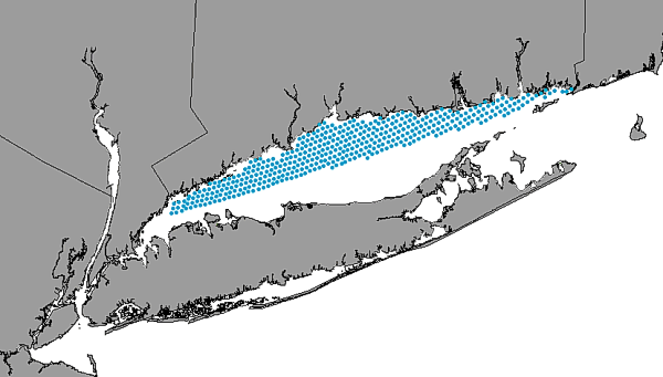
image showing the extent of the GIS layer and the location of samples compiled for detailed analysis of 35 species of the Long Island Sound benthic communities
Cross_Reference:
Citation_Information:
Originator: P. Pellegrino(comp.)
Originator: W. Hubbard(comp.)
Publication_Date: 19830000
Title:
Baseline shellfish data for the assessment of potential environmental impacts associated with energy activities in Connecticut's coastal zone
Series_Information:
Series_Name: Report to the State of Connecticut
Publication_Information:
Publication_Place: Hartford, CT
Publisher: Department of Agriculture, Aquaculture Division

Data_Quality_Information:
Attribute_Accuracy:
Attribute_Accuracy_Report:
Ship navigation was by Loran-C; biologic specimens were individually identified and counted, sediment data is based on visual observation.
Logical_Consistency_Report:
No additional checks for topological consistancy were performed on this data set.
Completeness_Report: None
Positional_Accuracy:
Horizontal_Positional_Accuracy:
Horizontal_Positional_Accuracy_Report: Ship navigation was by Loran-C
Quantitative_Horizontal_Positional_Accuracy_Assessment:
Horizontal_Positional_Accuracy_Value: 185-460 m
Horizontal_Positional_Accuracy_Explanation: Typical accuracy foor Loran-C
Vertical_Positional_Accuracy:
Vertical_Positional_Accuracy_Report: No tidal corrections performed
Quantitative_Vertical_Positional_Accuracy_Assessment:
Vertical_Positional_Accuracy_Value: 2
Vertical_Positional_Accuracy_Explanation: Tidal range is less than 2 m
Lineage:
Source_Information:
Source_Citation:
Citation_Information:
Originator: P. Pellegrino(comp.)
Originator: W. Hubbard(comp.)
Publication_Date: 19830000
Title:
Baseline shellfish data for the assessment of potential environmetal impacts associated with energy activities in Connecticut's coastal zone
Publication_Information:
Publication_Place: Hartford, CT
Publisher: Department of Agriculture, Aquaculture Division
Type_of_Source_Media: paper
Source_Time_Period_of_Content:
Time_Period_Information:
Single_Date/Time:
Calendar_Date: Unknown
Source_Currentness_Reference: Publication Date
Source_Citation_Abbreviation: Pellegrino and Hubbard, 1983
Source_Contribution:
Describes regional benthic communities in Long Island Sound
Process_Step:
Process_Description:
Sediment samples were collected by grab sampler and were wet sieved to remove the mud fraction. Coarse fractions were stored in formalin until individual species specimens could be identified and counted with a binocular microscope under reflected light.
Source_Used_Citation_Abbreviation:
Pellegrino and Hubbard's station locations and species populations
Process_Date: Unknown
Process_Contact:
Contact_Information:
Contact_Person_Primary:
Contact_Person: Roman Zajac
Contact_Organization: University of New Haven
Contact_Position: Professor
Contact_Address:
Address_Type: mailing and physical address
Address:
Biological and Environemtal Sciences
University of New Haven
300 Orange Avenue
City: West Haven
State_or_Province: CT
Postal_Code: 06516
Country: USA
Contact_Voice_Telephone: (203) 932-7114
Contact_Electronic_Mail_Address: zajacrn@charger.newhaven.edu
Process_Step:
Process_Description:
Text files of the navigation and species populations were imported into ArcInfo and shape files were generated
Process_Date: Unknown
Source_Produced_Citation_Abbreviation: benthos.dbf
Source_Produced_Citation_Abbreviation: benthos.shp
Source_Produced_Citation_Abbreviation: benthos.shx
Process_Contact:
Contact_Information:
Contact_Person_Primary:
Contact_Person: Roman N. Zajac
Contact_Organization: University of New Haven
Contact_Position: Professor
Contact_Address:
Address_Type: mailing address
Address:
Biology and Environmental Sciences
Univesity of New Haven
300 Orange Avenue
City: West Haven
State_or_Province: CT
Postal_Code: 06516
Country: USA
Contact_Voice_Telephone: (203) 932-7114
Contact_Electronic_Mail_Address: zajacrn@charger.newhaven.edu

Spatial_Data_Organization_Information:
Direct_Spatial_Reference_Method: Point
Point_and_Vector_Object_Information:
SDTS_Terms_Description:
SDTS_Point_and_Vector_Object_Type: Point
Point_and_Vector_Object_Count: 413

Spatial_Reference_Information:
Horizontal_Coordinate_System_Definition:
Planar:
Grid_Coordinate_System:
Grid_Coordinate_System_Name: Universal Transverse Mercator
Universal_Transverse_Mercator:
UTM_Zone_Number: 18
Transverse_Mercator:
Scale_Factor_at_Central_Meridian: 0.999600
Longitude_of_Central_Meridian: -075.000000
Latitude_of_Projection_Origin: +00.000000
False_Easting: 500000
False_Northing: 0
Planar_Coordinate_Information:
Planar_Coordinate_Encoding_Method: coordinate pair
Coordinate_Representation:
Abscissa_Resolution: 2000
Ordinate_Resolution: 2000
Planar_Distance_Units: Meters
Geodetic_Model:
Horizontal_Datum_Name: North American Datum of 1983
Ellipsoid_Name: WGS_1984
Semi-major_Axis: 6378137.00
Denominator_of_Flattening_Ratio: 0.003352810664747

Entity_and_Attribute_Information:
Detailed_Description:
Entity_Type:
Entity_Type_Label: benthos.dbf
Entity_Type_Definition: Shapefile attribute file
Entity_Type_Definition_Source: ESRI
Attribute:
Attribute_Label: Shape
Attribute_Definition: Point showing sample location
Attribute_Definition_Source: User defined
Attribute_Domain_Values:
Unrepresentable_Domain: point
Attribute_Domain_Values:
Range_Domain:
Attribute_Units_of_Measure: None
Attribute:
Attribute_Label: Allben_
Attribute_Definition:
Carried over from ArcInfo as an internal control parameter and has no applicable relevance to the use of the data
Attribute_Definition_Source: software computed
Attribute_Domain_Values:
Range_Domain:
Range_Domain_Minimum: 1
Range_Domain_Maximum: 413
Attribute_Measurement_Frequency: Unknown
Attribute:
Attribute_Label: Allben_id
Attribute_Definition:
Carried over from ArcInfo as an internal control parameter and has no applicable relevance to the use of the data.
Attribute_Definition_Source: software computer
Attribute_Domain_Values:
Range_Domain:
Range_Domain_Minimum: 1
Range_Domain_Maximum: 413
Attribute:
Attribute_Label: Station
Attribute_Definition: Station ID originally assigned in the field.
Attribute_Definition_Source: Pellegrino and Hubbard (1983)
Attribute_Domain_Values:
Range_Domain:
Range_Domain_Minimum: 1
Range_Domain_Maximum: 413
Attribute:
Attribute_Label: Amp
Attribute_Definition:
Cluster member identification based on multivariant cluster analysis of amphipod data.
Attribute_Definition_Source: Zajac and others (1998)
Attribute_Domain_Values:
Range_Domain:
Range_Domain_Minimum: 1
Range_Domain_Maximum: 16
Attribute:
Attribute_Label: Biv
Attribute_Definition:
Cluster member identification based on multivariant cluster analysis of bivalve data.
Attribute_Definition_Source: Zajac and others (1998)
Attribute_Domain_Values:
Range_Domain:
Range_Domain_Minimum: 1
Range_Domain_Maximum: 20
Attribute:
Attribute_Label: Poly
Attribute_Definition:
Cluster member identification based on multivariant cluster analysis of polychaete data.
Attribute_Definition_Source: Zajac and others (1998)
Attribute_Domain_Values:
Range_Domain:
Range_Domain_Minimum: 1
Range_Domain_Maximum: 29
Attribute:
Attribute_Label: Spall
Attribute_Definition:
Parameter generated during multivariant cluster analysis related to all species, but that has no applicable relevance to the use of the data.
Attribute_Definition_Source: Zajac and other (1998)
Attribute_Domain_Values:
Range_Domain:
Range_Domain_Minimum: 1
Range_Domain_Maximum: 15
Attribute:
Attribute_Label: Sp1name
Attribute_Definition: Pectinaria gouldi
Attribute_Definition_Source: User defined
Attribute_Domain_Values:
Unrepresentable_Domain: Character Field
Attribute:
Attribute_Label: Sp1data
Attribute_Definition:
Mean number of individuals/grab averaged across all stations in a cluster.
Attribute_Definition_Source: user defined
Attribute_Domain_Values:
Range_Domain:
Range_Domain_Minimum: 0
Range_Domain_Maximum: 40.9
Attribute:
Attribute_Label: Sp2name
Attribute_Definition: Nephtys incisa
Attribute_Definition_Source: user defined
Attribute_Domain_Values:
Unrepresentable_Domain: Character Field
Attribute:
Attribute_Label: Sp2data
Attribute_Definition:
Mean number of individuals/grab averaged across all stations in a cluster.
Attribute_Definition_Source: user defined
Attribute_Domain_Values:
Range_Domain:
Range_Domain_Minimum: 0
Range_Domain_Maximum: 11.2
Attribute:
Attribute_Label: Sp3name
Attribute_Definition: Mediomastus ambiseta
Attribute_Definition_Source: user defined
Attribute_Domain_Values:
Unrepresentable_Domain: Character Field
Attribute:
Attribute_Label: Sp3data
Attribute_Definition:
Mean number of individuals/grab averaged across all stations in a cluster.
Attribute_Definition_Source: user defined
Attribute_Domain_Values:
Range_Domain:
Range_Domain_Minimum: 0
Range_Domain_Maximum: 53.3
Attribute:
Attribute_Label: Sp4name
Attribute_Definition: Polydora websteri
Attribute_Definition_Source: user defined
Attribute_Domain_Values:
Unrepresentable_Domain: Character Field
Attribute:
Attribute_Label: Sp4data
Attribute_Definition:
Mean number of individuals/grab averaged across all stations in a cluster.
Attribute_Definition_Source: user defined
Attribute_Domain_Values:
Range_Domain:
Range_Domain_Minimum: 0
Range_Domain_Maximum: 3.45
Attribute:
Attribute_Label: Sp5name
Attribute_Definition: Aricidea jeffersyii
Attribute_Definition_Source: user defined
Attribute_Domain_Values:
Unrepresentable_Domain: Character Field
Attribute:
Attribute_Label: Sp5data
Attribute_Definition:
Mean number of individuals/grab averaged across all stations in a cluster.
Attribute_Definition_Source: user defined
Attribute_Domain_Values:
Range_Domain:
Range_Domain_Minimum: 0
Range_Domain_Maximum: 8.27
Attribute:
Attribute_Label: Sp6name
Attribute_Definition: Prionospio heterobranchia
Attribute_Definition_Source: user defined
Attribute_Domain_Values:
Unrepresentable_Domain: Character Field
Attribute:
Attribute_Label: Sp6data
Attribute_Definition:
Mean number of individuals/grab averaged across all stations in a cluster.
Attribute_Definition_Source: user defined
Attribute_Domain_Values:
Range_Domain:
Range_Domain_Minimum: 0
Range_Domain_Maximum: 13.8
Attribute:
Attribute_Label: Sp7name
Attribute_Definition: Paraonis fulgens
Attribute_Definition_Source: user defined
Attribute_Domain_Values:
Unrepresentable_Domain: Character Field
Attribute:
Attribute_Label: Sp7data
Attribute_Definition:
Mean number of individuals/grab averaged across all stations in a cluster.
Attribute_Definition_Source: user defined
Attribute_Domain_Values:
Range_Domain:
Range_Domain_Minimum: 0
Range_Domain_Maximum: 0.954
Attribute:
Attribute_Label: Sp8name
Attribute_Definition: Asabellides oculata
Attribute_Definition_Source: user defined
Attribute_Domain_Values:
Unrepresentable_Domain: Character Field
Attribute:
Attribute_Label: Sp8data
Attribute_Definition:
Mean number of individuals/grab averaged across all stations in a cluster.
Attribute_Definition_Source: user defined
Attribute_Domain_Values:
Range_Domain:
Range_Domain_Minimum: 0
Range_Domain_Maximum: 12.2
Attribute:
Attribute_Label: Sp9name
Attribute_Definition: Clymenella zonali
Attribute_Definition_Source: user defined
Attribute_Domain_Values:
Unrepresentable_Domain: Character Field
Attribute:
Attribute_Label: Sp9data
Attribute_Definition:
Mean number of individuals/grab averaged across all stations in a cluster.
Attribute_Definition_Source: user defined
Attribute_Domain_Values:
Range_Domain:
Range_Domain_Minimum: 0
Range_Domain_Maximum: 190.0
Attribute:
Attribute_Label: Sp10name
Attribute_Definition: Spiophanes bombyx
Attribute_Definition_Source: user defined
Attribute_Domain_Values:
Unrepresentable_Domain: Character Field
Attribute:
Attribute_Label: Sp10data
Attribute_Definition:
Mean number of individuals/grab averaged across all stations in a cluster.
Attribute_Definition_Source: user defined
Attribute_Domain_Values:
Range_Domain:
Range_Domain_Minimum: 0
Range_Domain_Maximum: 7.43
Attribute:
Attribute_Label: Sp11name
Attribute_Definition: Cirratulus grandis
Attribute_Definition_Source: user defined
Attribute_Domain_Values:
Unrepresentable_Domain: Character Field
Attribute:
Attribute_Label: Sp11data
Attribute_Definition:
Mean number of individuals/grab averaged across all stations in a cluster.
Attribute_Definition_Source: user defined
Attribute_Domain_Values:
Range_Domain:
Range_Domain_Minimum: 0
Range_Domain_Maximum: 3.33
Attribute:
Attribute_Label: Sp12name
Attribute_Definition: Cirratulus cirratus
Attribute_Definition_Source: user defined
Attribute_Domain_Values:
Unrepresentable_Domain: Character Field
Attribute:
Attribute_Label: Sp12data
Attribute_Definition:
Mean number of individuals/grab averaged across all stations in a cluster.
Attribute_Definition_Source: user defined
Attribute_Domain_Values:
Range_Domain:
Range_Domain_Minimum: 0
Range_Domain_Maximum: 8.4
Attribute:
Attribute_Label: Sp13name
Attribute_Definition: Lepidontus squamotus
Attribute_Definition_Source: user defined
Attribute_Domain_Values:
Unrepresentable_Domain: Character Field
Attribute:
Attribute_Label: Sp13data
Attribute_Definition:
Mean number of individuals/grab averaged across all stations in a cluster.
Attribute_Definition_Source: user defined
Attribute_Domain_Values:
Range_Domain:
Range_Domain_Minimum: 0
Range_Domain_Maximum: 2.27
Attribute:
Attribute_Label: Sp14name
Attribute_Definition: Steblospio benedicti
Attribute_Definition_Source: user defined
Attribute_Domain_Values:
Unrepresentable_Domain: Character Field
Attribute:
Attribute_Label: Sp14data
Attribute_Definition:
Mean number of individuals/grab averaged across all stations in a cluster.
Attribute_Definition_Source: user defined
Attribute_Domain_Values:
Range_Domain:
Range_Domain_Minimum: 0
Range_Domain_Maximum: 9.70
Attribute:
Attribute_Label: Sp15name
Attribute_Definition: Owenia fusiformis
Attribute_Definition_Source: user defined
Attribute_Domain_Values:
Unrepresentable_Domain: Character Field
Attribute:
Attribute_Label: Sp15data
Attribute_Definition:
Mean number of individuals/grab averaged across all stations in a cluster.
Attribute_Definition_Source: user defined
Attribute_Domain_Values:
Range_Domain:
Range_Domain_Minimum: 0
Range_Domain_Maximum: 1.98
Attribute:
Attribute_Label: Sp16name
Attribute_Definition: Nephtys picta
Attribute_Definition_Source: user defined
Attribute_Domain_Values:
Unrepresentable_Domain: Character Field
Attribute:
Attribute_Label: Sp16data
Attribute_Definition:
Mean number of individuals/grab averaged across all stations in a cluster.
Attribute_Definition_Source: user defined
Attribute_Domain_Values:
Range_Domain:
Range_Domain_Minimum: 0
Range_Domain_Maximum: 3.61
Attribute:
Attribute_Label: Sp17name
Attribute_Definition: Capitella capitata
Attribute_Definition_Source: user defined
Attribute_Domain_Values:
Unrepresentable_Domain: Character Field
Attribute:
Attribute_Label: Sp17data
Attribute_Definition:
Mean number of individuals/grab averaged across all stations in a cluster.
Attribute_Definition_Source: user defined
Attribute_Domain_Values:
Range_Domain:
Range_Domain_Minimum: 0
Range_Domain_Maximum: 2.64
Attribute:
Attribute_Label: Sp18name
Attribute_Definition: Amphareta arctica
Attribute_Definition_Source: user defined
Attribute_Domain_Values:
Unrepresentable_Domain: Character Field
Attribute:
Attribute_Label: Sp18data
Attribute_Definition:
Mean number of individuals/grab averaged across all stations in a cluster.
Attribute_Definition_Source: user defined
Attribute_Domain_Values:
Range_Domain:
Range_Domain_Minimum: 0
Range_Domain_Maximum: 6.19
Attribute:
Attribute_Label: Sp19name
Attribute_Definition: Prionospio tenuis
Attribute_Definition_Source: user defined
Attribute_Domain_Values:
Unrepresentable_Domain: Character Field
Attribute:
Attribute_Label: Sp19data
Attribute_Definition:
Mean number of individuals/grab averaged across all stations in a cluster.
Attribute_Definition_Source: user defined
Attribute_Domain_Values:
Range_Domain:
Range_Domain_Minimum: 0
Range_Domain_Maximum: 9.35
Attribute:
Attribute_Label: Sp20name
Attribute_Definition: Ampelisca abdita
Attribute_Definition_Source: user defined
Attribute_Domain_Values:
Unrepresentable_Domain: Character Field
Attribute:
Attribute_Label: Sp20data
Attribute_Definition:
Mean number of individuals/grab averaged across all stations in a cluster.
Attribute_Definition_Source: user defined
Attribute_Domain_Values:
Range_Domain:
Range_Domain_Minimum: 0
Range_Domain_Maximum: 12.40
Attribute:
Attribute_Label: Sp21name
Attribute_Definition: Unciola irrorata
Attribute_Definition_Source: user defined
Attribute_Domain_Values:
Unrepresentable_Domain: Character Field
Attribute:
Attribute_Label: Sp21data
Attribute_Definition:
Mean number of individuals/grab averaged across all stations in a cluster.
Attribute_Definition_Source: user defined
Attribute_Domain_Values:
Range_Domain:
Range_Domain_Minimum: 0
Range_Domain_Maximum: 8.68
Attribute:
Attribute_Label: Sp22name
Attribute_Definition: Leptocheirus pinguis
Attribute_Definition_Source: user defined
Attribute_Domain_Values:
Unrepresentable_Domain: Character Field
Attribute:
Attribute_Label: Sp22data
Attribute_Definition:
Mean number of individuals/grab averaged across all stations in a cluster.
Attribute_Definition_Source: user defined
Attribute_Domain_Values:
Range_Domain:
Range_Domain_Minimum: 0
Range_Domain_Maximum: 9.63
Attribute:
Attribute_Label: Sp23name
Attribute_Definition: Ampelisca vadorum
Attribute_Definition_Source: user defined
Attribute_Domain_Values:
Unrepresentable_Domain: Character Field
Attribute:
Attribute_Label: Sp23data
Attribute_Definition:
Mean number of individuals/grab averaged across all stations in a cluster.
Attribute_Definition_Source: user defined
Attribute_Domain_Values:
Range_Domain:
Range_Domain_Minimum: 0
Range_Domain_Maximum: 21.3
Attribute:
Attribute_Label: Sp24name
Attribute_Definition: Protohaustorius wigleyi
Attribute_Definition_Source: user defined
Attribute_Domain_Values:
Unrepresentable_Domain: Character Field
Attribute:
Attribute_Label: Sp24data
Attribute_Definition:
Mean number of individuals/grab averaged across all stations in a cluster.
Attribute_Definition_Source: user defined
Attribute_Domain_Values:
Range_Domain:
Range_Domain_Minimum: 0
Range_Domain_Maximum: 17.7
Attribute:
Attribute_Label: Sp25name
Attribute_Definition: Ancanthohaustorius millsi
Attribute_Definition_Source: user defined
Attribute_Domain_Values:
Unrepresentable_Domain: Character Field
Attribute:
Attribute_Label: Sp25data
Attribute_Definition:
Mean number of individuals/grab averaged across all stations in a cluster.
Attribute_Definition_Source: user defined
Attribute_Domain_Values:
Range_Domain:
Range_Domain_Minimum: 0
Range_Domain_Maximum: 2.04
Attribute:
Attribute_Label: Sp26name
Attribute_Definition: Arginina longicornis
Attribute_Definition_Source: user defined
Attribute_Domain_Values:
Unrepresentable_Domain: Character Field
Attribute:
Attribute_Label: Sp26data
Attribute_Definition:
Mean number of individuals/grab averaged across all stations in a cluster.
Attribute_Definition_Source: user defined
Attribute_Domain_Values:
Range_Domain:
Range_Domain_Minimum: 0
Range_Domain_Maximum: 10.7
Attribute:
Attribute_Label: Sp27name
Attribute_Definition: Corophium acheruscum
Attribute_Definition_Source: user defined
Attribute_Domain_Values:
Unrepresentable_Domain: Character Field
Attribute:
Attribute_Label: Sp27data
Attribute_Definition:
Mean number of individuals/grab averaged across all stations in a cluster.
Attribute_Definition_Source: user defined
Attribute_Domain_Values:
Range_Domain:
Range_Domain_Minimum: 0
Range_Domain_Maximum: 18.4
Attribute:
Attribute_Label: Sp28name
Attribute_Definition: Mulinia lateralis
Attribute_Definition_Source: user defined
Attribute_Domain_Values:
Unrepresentable_Domain: Character Field
Attribute:
Attribute_Label: Sp28data
Attribute_Definition:
Mean number of individuals/grab averaged across all stations in a cluster.
Attribute_Definition_Source: user defined
Attribute_Domain_Values:
Range_Domain:
Range_Domain_Minimum: 0
Range_Domain_Maximum: 299.0
Attribute:
Attribute_Label: Sp29name
Attribute_Definition: Nucula annulata
Attribute_Definition_Source: user defined
Attribute_Domain_Values:
Unrepresentable_Domain: Character Field
Attribute:
Attribute_Label: Sp29data
Attribute_Definition:
Mean number of individuals/grab averaged across all stations in a cluster.
Attribute_Definition_Source: user defined
Attribute_Domain_Values:
Range_Domain:
Range_Domain_Minimum: 0
Range_Domain_Maximum: 124.0
Attribute:
Attribute_Label: Sp30name
Attribute_Definition: Pitar morrhuana
Attribute_Definition_Source: user defined
Attribute_Domain_Values:
Unrepresentable_Domain: Character Field
Attribute:
Attribute_Label: Sp30data
Attribute_Definition:
Mean number of individuals/grab averaged across all stations in a cluster.
Attribute_Definition_Source: user defined
Attribute_Domain_Values:
Range_Domain:
Range_Domain_Minimum: 0
Range_Domain_Maximum: 5.38
Attribute:
Attribute_Label: Sp31name
Attribute_Definition: Telline agilis
Attribute_Definition_Source: user defined
Attribute_Domain_Values:
Unrepresentable_Domain: Character Field
Attribute:
Attribute_Label: Sp31data
Attribute_Definition:
Mean number of individuals/grab averaged across all stations in a cluster.
Attribute_Definition_Source: user defined
Attribute_Domain_Values:
Range_Domain:
Range_Domain_Minimum: 0
Range_Domain_Maximum: 12.8
Attribute:
Attribute_Label: Sp32name
Attribute_Definition: Yoldia lamata
Attribute_Definition_Source: user defined
Attribute_Domain_Values:
Unrepresentable_Domain: Character Field
Attribute:
Attribute_Label: Sp32data
Attribute_Definition:
Mean number of individuals/grab averaged across all stations in a cluster.
Attribute_Definition_Source: user defined
Attribute_Domain_Values:
Range_Domain:
Range_Domain_Minimum: 0
Range_Domain_Maximum: 2.33
Attribute:
Attribute_Label: Sp33name
Attribute_Definition: Pandora gouldina
Attribute_Definition_Source: user defined
Attribute_Domain_Values:
Unrepresentable_Domain: Character Field
Attribute:
Attribute_Label: Sp33data
Attribute_Definition:
Mean number of individuals/grab averaged across all stations in a cluster.
Attribute_Definition_Source: user defined
Attribute_Domain_Values:
Range_Domain:
Range_Domain_Minimum: 0
Range_Domain_Maximum: 2.04
Attribute:
Attribute_Label: Sp34name
Attribute_Definition: Erisis directus
Attribute_Definition_Source: user defined
Attribute_Domain_Values:
Unrepresentable_Domain: Character Field
Attribute:
Attribute_Label: Sp34data
Attribute_Definition:
Mean number of individuals/grab averaged across all stations in a cluster.
Attribute_Definition_Source: user defined
Attribute_Domain_Values:
Range_Domain:
Range_Domain_Minimum: 0
Range_Domain_Maximum: 1.03
Attribute:
Attribute_Label: Sp35name
Attribute_Definition: Mytilus edulis
Attribute_Definition_Source: user defined
Attribute_Domain_Values:
Unrepresentable_Domain: Character Field
Attribute:
Attribute_Label: Sp35data
Attribute_Definition:
Mean number of individuals/grab averaged across all stations in a cluster.
Attribute_Definition_Source: user defined
Attribute_Domain_Values:
Range_Domain:
Range_Domain_Minimum: 0
Range_Domain_Maximum: 36.40
Attribute:
Attribute_Label: Sed_type
Attribute_Definition:
Bulk sediment characteristics. Varibales in this codeset
  • gr - gravel
  • gs - gravelly sand
  • cs - coarse sand
  • ms - medium sand
  • fs - fine sand
  • st - silt
Attribute_Definition_Source: Pellegrino and Hubbard, 1983
Attribute_Domain_Values:
Codeset_Domain:
Codeset_Name: Sed_type
Codeset_Source: Pellegrino and Hubbard, 1983
Attribute:
Attribute_Label: Frequency
Attribute_Definition:
Parameter generated during multivariant cluster analysis that has no applicable relevance to the use of the data.
Attribute_Definition_Source: Zajac and others, 1998
Attribute_Domain_Values:
Range_Domain:
Range_Domain_Minimum: 1
Range_Domain_Maximum: 54
Overview_Description:
Entity_and_Attribute_Overview:
The original studies were conducted to describe the disturbution of the benthic infauna within Connecticut waters in lIS.
Entity_and_Attribute_Detail_Citation: Pellegrino and Hubbard, 1983

Distribution_Information:
Distributor:
Contact_Information:
Contact_Person_Primary:
Contact_Person: Roman Zajac
Contact_Organization: University of New Haven
Contact_Position: Professor
Contact_Address:
Address_Type: mailing address
Address:
Biological and Environmental Sciences
University of New Haven
300 Orange Avenue
City: West Haven
State_or_Province: CT
Postal_Code: 06516
Country: USA
Contact_Voice_Telephone: 203-932-7114
Contact_Electronic_Mail_Address: zajacrn@charger.newhaven.edu
Resource_Description: Long Island Sound: benthos.shp
Distribution_Liability:
Although this derived data set and its lineage dataset have sed by the University of New Haven and the U. S. Geological Survey, no warranty, expressed or implied, is made by UNH or the USGS as to the accuracy of the data and/or related materials. The act of distribution shall not constitute any such warranty, and no responsibility is assumed by the USGS in the use of these data or related materials.
Standard_Order_Process:
Digital_Form:
Digital_Transfer_Information:
Format_Name: ARCV
Format_Information_Content:
benthos.dbf
benthos.shp
benthos.shx
benthos.avl
benthos.sbn
benthos.sbx
File_Decompression_Technique: No compression applied
Transfer_Size: 584Kbytes
Digital_Transfer_Option:
Offline_Option:
Offline_Media: CD-ROM
Recording_Capacity:
Recording_Density: 650
Recording_Density_Units: Mbytes
Recording_Format: ISO 9600
Compatibility_Information:
The user must have a system with a CD-ROM capable of reading an ISO-9660 standard CD-ROM disk. To browse the information contained on this disk, the user must also have a current version of WWW browser available. The user must also have the software installed on their computer system capable to unzip the archived file.
Digital_Form:
Digital_Transfer_Information:
Format_Name: ARCV
Format_Information_Content:
The six ArcView files (benthos.dbf, benthos.shp, benthos.shx, benthos.avl, benthos.sbn, benthos.sbx) comprising a GIS layer showing the location of the Long Island Sound benthos samples.
File_Decompression_Technique: zip
Transfer_Size: 26Kbytes
Digital_Transfer_Option:
Offline_Option:
Offline_Media: CD-ROM
Recording_Capacity:
Recording_Density: 650
Recording_Density_Units: Mbytes
Recording_Format: ISO 9600
Compatibility_Information:
The user must have a system with a CD-ROM capable of reading an ISO-9660 standard CD-ROM disk. To browse the information contained on this disk, the user must also have a current version of WWW browser available. The user must also have the software installed on their computer system capable to unzip the archived file.
Fees: none
Custom_Order_Process: None
Technical_Prerequisites:
This layer is available in ArcView 3.2 format. Users must have ArcView 3.0 or later, or another GIS application capable of importing the data.
Available_Time_Period:
Time_Period_Information:
Single_Date/Time:
Calendar_Date: 20000000

Metadata_Reference_Information:
Metadata_Date: 20000810
Metadata_Contact:
Contact_Information:
Contact_Person_Primary:
Contact_Person: Valerie Paskevich
Contact_Organization: U. S. Geological Survey
Contact_Position: Computer Specialist
Contact_Address:
Address_Type: mailing address
Address: 384 Woods Hole Road
City: Woods Hole
State_or_Province: MA
Postal_Code: 02543-1598
Country: USA
Contact_Voice_Telephone: (508) 548-8700 x2281
Contact_Facsimile_Telephone: (508) 457-2310
Contact_Electronic_Mail_Address: vpaskevich@usgs.gov
Metadata_Standard_Name: FGDC Content Standards for Digital Geospatial Metadata
Metadata_Standard_Version: FGDC-STD-001-1998
Metadata_Time_Convention: Local time
Metadata_Access_Constraints: None
Metadata_Use_Constraints: None

Generated by mp version 2.5.3 on Thu Aug 10 19:35:39 2000