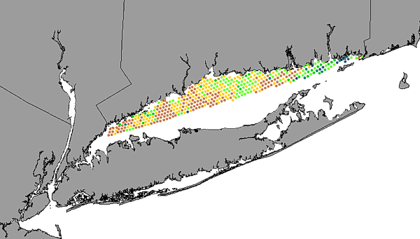
sample locations and total number of species found at each station from
Pellegrino and Hubbard (1983)
Publication_Information:
Publication_Place: Woods Hole Field Center, Woods Hole, MA
Publisher: U.S. Geological Survey
Larger_Work_Citation:
Citation_Information:
Originator: Valerie Paskevich(ed.)
Originator: Larry Poppe(ed.)
Publication_Date: 20000000
Title:
Georeferenced sea-floor mapping and bottom photography in Long Island Sound
Series_Information:
Series_Name: U.S. Geological Survey Open-File Report
Issue_Identification: 00-304
Publication_Information:
Publication_Place: Woods Hole Field Center, Woods Hole, MA
Publisher: U.S. Geological Survey
Description:
Abstract:
This GIS layer provides detailed information from Pellegrino and Hubbard
(1983). It shows the sample locations and provides a summary of the total
number of species found at each station (species_richness).
Purpose:
This data layer, which focuses on benthic communities, was developed as
part of a cooperative project between the University of New Haven, the
Connecticut DEP, and the U.S. Geological Survey. Benthic communities are
an integral component of the ecology of LIS.
Understanding the role that spatial heterogeneity plays in the dynamic
of benthic landscapes may be a key to developing a better understanding
of the estuarine ecology and the impacts of huuman activity. The purpose
of providing this data layer is to help establish a regional framework
for developing a more extensive GIS for benthic communities in LIS that
can be used for education, research, and environmental management.
Time_Period_of_Content:
Time_Period_Information:
Single_Date/Time:
Calendar_Date: 19830000
Currentness_Reference: Publication Date
Status:
Progress: Complete
Maintenance_and_Update_Frequency: None planned
Spatial_Domain:
Bounding_Coordinates:
West_Bounding_Coordinate: -73.6418
East_Bounding_Coordinate: -71.8630
North_Bounding_Coordinate: 41.3536
South_Bounding_Coordinate: 40.9067
Keywords:
Theme:
Theme_Keyword_Thesaurus: General
Theme_Keyword: U. S. Geological Survey
Theme_Keyword: USGS
Theme_Keyword: Coastal and Marine Geology Team
Theme_Keyword: Coastal and Marine Geology Program
Theme_Keyword: Woods Hole Field Center
Theme_Keyword: Connecticut Department of Environmental Protection
Theme_Keyword: University of New Haven
Theme_Keyword: ArcView
Theme_Keyword: arcview
Theme_Keyword: shapefile
Theme_Keyword: points
Theme_Keyword: Pellegrino
Theme_Keyword: Hubbard
Theme_Keyword: biology
Theme_Keyword: communities
Theme_Keyword: infauna
Theme_Keyword: shellfish
Theme_Keyword: assessment
Theme_Keyword: environmental impacts
Place:
Place_Keyword_Thesaurus: General
Place_Keyword: Long Island Sound
Place_Keyword: estuary
Place_Keyword: Connecticut
Place_Keyword: New York
Access_Constraints:
The University of New Haven and the U.S. Geological Survey must be referenced
as the originator of the data set in any future products or as research
derived from these data. Although this derived data set and its lineage
dataset have been used by the University of New Haven and the USGS, no
warranty, expressed or implied, is made by the University of New Haven
or the USGS as to the accuracy of the data and/or related materials. The
act of distribution shall not constitute any such warranty, and no responsibility
is assumed by the University of New Haven or the USGS in the use of the
data or related materials.
Vertical_Positional_Accuracy_Explanation: Tidal range is less than
2 m
Lineage:
Source_Information:
Source_Citation:
Citation_Information:
Originator: P. Pellegrino(comp.)
Originator: W. Hubbard(comp.)
Publication_Date: 19830000
Title:
Baseline shellfish data for the assessment of potential environmetal impacts
associated with energy activities in Connecticut's coastal zone
Publication_Information:
Publication_Place: Hartford, CT
Publisher: Department of Agriculture, Aquaculture Division
Type_of_Source_Media: paper
Source_Time_Period_of_Content:
Time_Period_Information:
Single_Date/Time:
Calendar_Date: Unknown
Source_Currentness_Reference: Publication Date
Source_Citation_Abbreviation: Pellegrino and Hubbard, 1983
Source_Contribution:
Describes regional benthic communities in Long Island Sound
Process_Step:
Process_Description:
Sediment samples were collected by grab sampler and were wet sieved to
remove the mud fraction. Coarse fractions were stored in formalin until
individual species specimens could be identified and counted with a binocular
microscope under reflected light.
Source_Used_Citation_Abbreviation:
Pellegrino and Hubbard's station locations and species populations
Process_Date: Unknown
Process_Contact:
Contact_Information:
Contact_Person_Primary:
Contact_Person: Roman Zajac
Contact_Organization: University of New Haven
Contact_Position: Professor
Contact_Address:
Address_Type: mailing and physical address
Address:
Biological and Environmental Sciences University of New Haven
Carried over from the ArcInfo attribute RICHSED#. RICHSED# is an ArcInfo
internal control parameter and has no applicable relevance to the use of
the data.
Attribute_Definition_Source: User Defined
Attribute_Domain_Values:
Range_Domain:
Range_Domain_Minimum: 0
Range_Domain_Maximum: 413
Attribute:
Attribute_Label: Richsed_id
Attribute_Definition:
Carried over from the ArcInfo attribute RICHSED-ID. RICHSED-ID is an ArcInfo
internal control parameter and has no applicable relevance to the use of
the data.
Attribute_Definition_Source: User Defined
Attribute_Domain_Values:
Range_Domain:
Range_Domain_Minimum: 0
Range_Domain_Maximum: 413
Attribute:
Attribute_Label: Spec_
Attribute_Definition:
The numbers in this field represent the total number of species identified.
Attribute_Definition_Source: Zajac and others 1998
Attribute_Domain_Values:
Range_Domain:
Range_Domain_Minimum: 0
Range_Domain_Maximum: 58
Attribute_Units_of_Measure: Individual species
Attribute:
Attribute_Label: Indy_
Attribute_Definition:
Number of individual specimens of species that were inventoried as part
of Pellegrino and Hubbard (1983)
Attribute_Definition_Source: Zajac and others, 1998
Attribute_Domain_Values:
Range_Domain:
Range_Domain_Minimum: 0
Range_Domain_Maximum: 1632
Attribute_Units_of_Measure: Individual specimens
Attribute:
Attribute_Label: Station
Attribute_Definition: Original station ID
Attribute_Definition_Source: Pellegrino and Hubbard, 1983
Attribute_Domain_Values:
Range_Domain:
Range_Domain_Minimum: 1
Range_Domain_Maximum: 413
Attribute_Units_of_Measure: Individual stations
Attribute:
Attribute_Label: Range
Attribute_Definition:
Range within which the total number of species 0-5, 6-10, 11-15, 16-20,
21-25, 26-30, 31-40, 41-50, and 51-60.
Attribute_Definition_Source: Pellegrino and Hubbard, 1983
Attribute_Domain_Values:
Unrepresentable_Domain: A series of intervals of 5 and 10 species
Attribute:
Attribute_Label: Rangecode
Attribute_Definition:
An alphabetic code generated to represent the available ranges of species
identified in the samples (species 6-10; c = 11-15; 26-30; g = 31-40; h
= 41-50; 51-60).
Attribute_Definition_Source: Pellegrino and Hubbard, 1983
Attribute_Domain_Values:
Codeset_Domain:
Codeset_Name: Rangecode
Codeset_Source: Pellegrino and Hubbard, 1983
Attribute_Domain_Values:
Range_Domain:
Attribute_Units_of_Measure: Intervals of 5 and 10 species
Overview_Description:
Entity_and_Attribute_Overview:
The original studies were conducted to describe the distribution of the
benthic infauna within Connecticut waters in LIS. The data in this layer
describe the species richness (numbers of species in the sample).
Entity_and_Attribute_Detail_Citation: Pellegrino and Hubbard, 1983
Resource_Description: Long Island Sound: specrich.shp
Distribution_Liability:
Although this derived data set and its lineage dataset have sed by the
University of New Haven and the U. S. Geological Survey, no warranty, expressed
or implied, is made by UNH or the USGS as to the accuracy of the data and/or
related materials. The act of distribution shall not constitute any such
warranty, and no responsibility is assumed by the USGS in the use of these
data or related materials.
Standard_Order_Process:
Digital_Form:
Digital_Transfer_Information:
Format_Name: ARCV
Format_Information_Content:
specrich.dbf
specrich.shp
specrich.shx
specrich.avl
specrich.sbn
specrich.sbx
File_Decompression_Technique: No compression applied
Transfer_Size: 53Kbytes
Digital_Transfer_Option:
Offline_Option:
Offline_Media: CD-ROM
Recording_Capacity:
Recording_Density: 650
Recording_Density_Units: Mbytes
Recording_Format: ISO 9600
Compatibility_Information:
The user must have a system with a CD-ROM capable of reading an ISO-9660
standard CD-ROM disk. To browse the information contained on this disk,
the user must also have a current version of a WWW browser available. The
user must also have the software installed on their computer system capable
to unzip the archived file.
Digital_Form:
Digital_Transfer_Information:
Format_Name: ARCV
Format_Information_Content:
The six ArcView files (specrich.dbf, specrich.shp, specrich.shx, specrich.avl,
specrich.sbn, specrich.sbx) comprising a GIS layer showing the location
of the Long Island Sound specrich samples.
File_Decompression_Technique: zip
Transfer_Size: 18Kbytes
Digital_Transfer_Option:
Offline_Option:
Offline_Media: CD-ROM
Recording_Capacity:
Recording_Density: 650
Recording_Density_Units: Mbytes
Recording_Format: ISO 9600
Compatibility_Information:
The user must have a system with a CD-ROM capable of reading an ISO-9660
standard CD-ROM disk. To browse the information contained on this disk,
the user must also have a current version of a WWW browser available. The
user must also have the software installed on their computer system capable
to unzip the archived file.
Fees: none
Technical_Prerequisites:
This layer is available in ArcView 3.2 format. Users must have ArcView
3.0 or later, or another GIS application capable of importing the data.
Available_Time_Period:
Time_Period_Information:
Single_Date/Time:
Calendar_Date: 20001101
Metadata_Reference_Information:
Metadata_Date: 20000812
Metadata_Contact:
Contact_Information:
Contact_Person_Primary:
Contact_Person: Larry Poppe
Contact_Organization: U. S. Geological Survey
Contact_Position: Computer Specialist
Contact_Address:
Address_Type: mailing address
Address: 384 Woods Hole Road
City: Woods Hole
State_or_Province: MA
Postal_Code: 02543-1598
Country: USA
Contact_Voice_Telephone: (508) 548-8700 x2314
Contact_Facsimile_Telephone: (508) 457-2310
Contact_Electronic_Mail_Address: lpoppe@usgs.gov
Metadata_Standard_Name: FGDC Content Standards for Digital Geospatial
Metadata
Metadata_Standard_Version: FGDC-STD-001-1998
Metadata_Time_Convention: Local time
Metadata_Access_Constraints: None
Metadata_Use_Constraints: None
Generated by mp
version 2.5.3 on Sat Aug 12 09:48:32 2000