
U.S. Geological
Survey
Open-File Report 00-306 Online Version 1.0
Initial Report on IMAGES V Cruise of the Marion-Dufresne
to the Chesapeake Bay June 20-22, 1999
Thomas M. Cronin, editor
U.S. Geological Survey, Reston, Va. 20192
Prepared with the editorial assistance of
R. Stamm and J. Damon
In cooperation with the
U.S. Naval Research Laboratory
Maryland Geological Survey
U.S. Environmental Protection Agency
Institut Français pour la Recherche et la Technologie Polaires
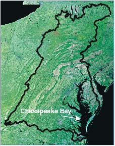
Satellite image mosaic of the Chesapeake Bay and its watershed (outlined in black). The mosaic is composed of Landsat thematic mapper scenes collected in 1990-94. |
Sediment coring in Chesapeake Bay on the Marion-Dufresne on June 20 - 22, 1999 was carried out as part of an interdisciplinary study of Holocene paleoclimate and ecosystem history, methanogenesis, and geological evolution of modern Chesapeake Bay. The Marion-Dufresne crew and the scientific staff used a giant piston corer to recover the longest continuous sediment cores ever collected in Chesapeake Bay for scientific research. A total of six cores at five sites were obtained, recovering a total of about 6,800 cm of mainly late Pleistocene and Holocene sediment from the mid-bay near the Potomac River mouth, the Parker Creek - Calvert Cliffs area, and the Rhode River area. Preliminary dating of the sediments indicates that coring bottomed out variously in Miocene marine deposits, late glacial fluvial gravels, Holocene oyster beds, and late Pleistocene estuarine muds. The coring was successful in terms of sediment recovery (1.7 to 4.4 times greater than that from prior coring in the same areas with piston and Makareth corers), percentage of core recovery as a function of barrel penetration (composite recovery ~ 79 % total penetration) and the extremely shallow water depths (10 to 25 meters). The Marion-Dufresne coring was also successful in obtaining the first nearly complete Holocene sedimentary records from an estuary in the eastern United States. These cores are now being analyzed for physical parameters, sedimentary geochemistry, micropaleontology, stable isotopes, trace and major elemental analyses, dissolved methane, and late Quaternary paleoclimatic and environmental history. |
|
CONTENTS
[Chapters will open in a new window] Chapter 1: IMAGES V Coring in Chesapeake Bay, June 20-22, 1999: Introduction Chapter 2: Geophysical Environment in Chesapeake Bay: Marion-Dufresne Sites MD99-2205, 2206 and 2208 Chapter 3: Marion-Dufresne Coring in Chesapeake Bay: Geophysical Environment at Sites MD99-2204 and 2207 Chapter 4: Geophysical Environment: Site MD99-2209 Chapter 5: Sedimentology and Core Descriptions, Marion-Dufresne Cores MD99-2204 through - 2209, Chesapeake Bay Chapter 6: Radiocarbon Dating of Marion-Dufresne Cores MD99-2204, -2207, and -2209, Chesapeake Bay Chapter 7: Holocene Palynology from Marion-Dufresne Cores MD99-2209 and 2207 from Chesapeake Bay: Impacts of Climate and Historic Land-Use Change Chapter 8: Holocene Dinoflagellate Cysts from Marion-Dufresne Core MD99-2209, Chesapeake Bay Chapter 9: Holocene Paleoclimate from Chesapeake Bay Ostracodes and Benthic Foraminifera from Marion-Dufresne core MD99-2209 Chapter 10: Trace Metals, Stable Isotopes, and Biogenic Silica from Cores Collected at Marion-Dufresne Site MD99-2209, Chesapeake Bay Chapter 11: Physical Properties of Marion-Dufresne Cores MD99 2204 - 2209 and Magnetic Secular Variation Studies of MD99 2207 Chapter 12: Color Banding of Core MD99-2207 from the Middle Chesapeake Bay Chapter 13: Porewater Methane Geochemistry of Marion-Dufresne Cores MD99-2205 and -2206 |
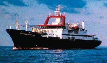
French research vessel Marion-Dufresne. Coring onboard the Marion-Dufresne in June, 1999 produced the longest sediment cores from Chesapeake Bay. Photograph courtesy of the Institut Français pour la Recherche et la Technologie Polaires. |
For questions about the content of this report, contact Tom Cronin at tcronin@usgs.gov.