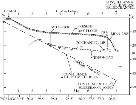
| Figure 2.8. Profile along thalweg axis of Parkers Creek paleochannel, starting landward of shoreline, where Miocene "basement" is 3 m below modern sea level (Froomer, 1979). Depth to top of methane gas (G) reflector above paleochannel is indicated by "T" marks , based only on NRL chirp profile data (Fig. 2.3). Plum Point Creek paleochannel is the major tributary coming from NW and NNW in Figure 2.4. Depth to Parkers Creek paleochannel lip and MD cores 2205 and 2206 (dashed vertical lines) have been projected onto thalweg axis profile along isobaths (Fig. 2.4). Core MD99-2208 is located in the thalweg profile. Heavy dashed line, indicating thalweg depth, is conjectural, its confluence with the Susquehanna (Cape Charles) paleochannel is perhaps as deep as 55 m bsl (Fig. 2.2; Colman and others, 1992). |
TO RETURN TO REPORT, CLOSE THIS WINDOW.
U.S. Department of Interior, U.S. Geological Survey
URL of this page: https://pubs.usgs.gov/openfile/of00-306/chapter2/fig2-8.html
Maintained by: Eastern Publications Group Web Team
Last modified: 03.28.01 (krw)