|
Geological Survey of Canada 234B-615 Booth St. Ottawa, Canada K1A 0E9 Telephone: (613) 992-3562 Fax: (613) 995-9273 e-mail: Brodaric@gsc.nrcan.gc.ca |
The Pennsylvania State University GeoVISTA Center Department of Geography 333 Walker Bldg. University Park, PA 16802-5011 Telephone: (814) 237-3916 Fax: (814) 863-7943 e-mail: bmb184@psu.edu |
Since the 1980's, the Geological Survey of Canada has been deploying various technologies to augment field-based geologic surveying and to develop a digital base of geologic field information. These efforts have been largely successful in migrating manual field data management techniques to digital methods, but they have been arguably less successful in stimulating new scientific practices and insights. Mylar and ink have been admirably replaced with computer screen and keyboard, resulting in effective and efficient map production and database construction, but scientific progress resulting from these advances has not kept pace. What are the barriers to such progress? The following sections explore this question by summarizing past and present GSC efforts, and by identifying problem areas and potential solutions.
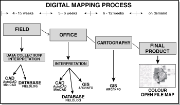
The successful deployment of this system has benefitted both corporate entities and individual scientists, mainly by improving the efficiency of transforming data from a single data store to other formats, and from one media to another; e.g., from notebook to map. For individuals this has meant an overall reduction in the manual labor associated with various cartographic, data management and analysis tasks, both in the field and in the office. For the agency, more efficient on-site field data management has enabled more data, and more data types, to be assimilated in the field, permitting the launching of more complex mapping programs involving multi-disciplinary teams (Broome et. al., 1993). It has also led to timely and cost-effective information distribution, as data is digitally managed from its inception to its release, from the field through to publication (Figure 2). Products are now released in some or all of the following formats: on traditional paper, on CD-ROMs, and also via the Internet.
|
Figure 2. The stages and approximate duration of the digital map production process at the GSC (this figure from K. Baker, GSC, per. comm.). |
These successes may be largely attributed to (1) a flexible system design that could be tailored to a broad spectrum of geological and administrative conditions and goals, and (2) readily available and knowledgeable technical support. It is the former factor, that of system design, that is of specific interest here.
|
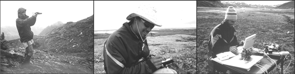
| Figure 3. Examples of the three main technologic factors influencing field system design: geographic positioning (left), on site data recording (middle), and information management and manipulation for geologic interpretation (right). Photos courtesy of various geologists from the Geological Survey of Canada. |
Apart from flexibility, field systems should also be easy to use. Ease of use and flexibility, however, tend to be inversely proportional; indeed, as the FieldLog system has expanded it has become more complex. How to retain flexibility without sacrificing usability? The challenges to be overcome may be categorized as being either technologic or geologic.
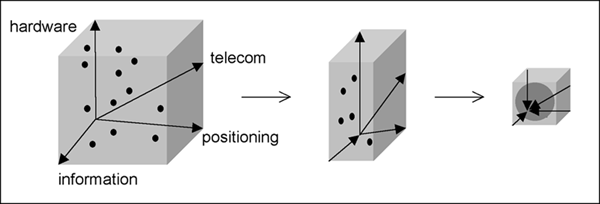
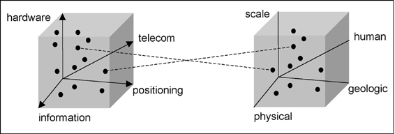
This admixture may be portrayed as a technologic space consisting of four axes: (1) mobile hardware, (2) information, (3) positioning and (4) telecommunication (Figure 4, left). The challenge with this mix of technologies is to select the appropriate combination for the project at hand, which amounts to selecting the optimal point in this technologic space. Yet, how is one to stay abreast of rapid technologic change, and how can geologic field systems unify these diverging elements into convergent solutions such that technology will be developed to serve geological needs a priori, rather than awkwardly adapted afterwards? It is clear that to generate convergence in this space the geologic community must take control of whatever factors it can. This amounts to seizing control of its information requirements and thereby reversing the expansion of the information axis, effectively shrinking the technologic space and eventually coercing developments in the other axes towards geologic information requirements (Figure 4). In short, enhancements in geologic information modeling and management may provide a nucleus upon which developers of technology can create geologic solutions. This is quite opposite to the current trend in field systems, where systems are composed of a loose cobbling of diverse technologies, each demanding a unique and complex expertise.
|
| Figure 4. Reducing the number of potential field system solutions involves diminishment of the growing technology space (on the left) via information modeling and management; this should in turn attract geologic-technologic developments to further reduce the space, effectively concentrating the range of technologic solutions. |
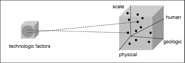
Like their technologic counterparts, these non-technologic variables (i.e., physical geography, geologic conditions, scale and human factors) may also be portrayed as the base axes of a space -- a field geology space (Figure 5, right). However, unlike the technologic space such a field geology space is relatively static, as technology changes much more rapidly than, say, physical geography or geologic theory. Controlling certain human factors such as technical literacy may aid in managing this space, however, the degree to which political and economic variables can be directed is arguable, as is the degree to which their often drastic effects can be mitigated by improved technical know-how. Consequently, the predominant challenge in configuring field system solutions involves matching field geologic situations within a relatively static geologic space to an expanding space of technologic solutions. This can be visualized as matching a point in field geologic space to one in technologic space (Figure 5). Success in this is predicated on the presence of individuals possessing expertise in both spaces, implying a prerequisite shift in geoscientific personnel profiles and education practices. Appropriating the technologic space by modeling and managing information, as suggested above, should allay the severity of this knowledge shift and should provide a framework for geo-technologic dialog and education. But, how to do this?
|
| Figure 5. Field system configuration involves appropriately matching a geologic situation in the field geologic space (on the right) to a technologic solution in the technologic space (on the left). |
|
| Figure 6. Improved matching of geologic situation (right) with technologic solution (left) by reducing the number of field system solutions. Enhanced information modeling and management should result in more concentrated technologic development along all technologic axes: i.e., defining information guidelines and operational requirements should attract and focus the development of technologies, shrinking the technologic space (left), and consequently improving the integration of diverse technologies for geologic field computing purposes. This should in turn reduce duplicate development, technologic dispersion, education requirements, and lead to quicker revision cycles for technology. |
Information content issues are related to the access, delivery, and utility of the information: they are concerned with how geologic information is reached and used. The explosion in the use of the Internet, and the subsequent chaotic availability of large amounts of heterogeneous data, have caused both government (Broome, 2000) and academia (AGU, 2000) to call for the management of these resources in some coordinated and pooled fashion. Growing awareness of the need to demonstrate relevance to society indicates these systems must also provide a bridge between geology and other knowledge domains (e.g., climate change, environment, etc.), possibly through software transformations (Journeay, et. al., 2000). This involves capturing information and reasoning techniques traditionally held in the minds of the geologist, implying that improved geologic information utility is related to developing enhanced structures that draw upon the way humans represent and reason with geologic information. The concern with such structures here does not imply that the various other technical and political hurdles to be overcome are insignificant, as they are not, yet if inadequate structuring of information renders it mostly unusable, then all else is for naught.
Information structure issues are concerned with optimizing how geologic interpretation is represented, and how it is constructed via reasoning. Some geologic problems are reasonably well constrained and the interpretative element diminished, permitting geologic features to be directly modeled in our digital data representations (as per most geologic data models: e.g., Bain and Giles, 1997; PPDM, 2000; Richard, 1999). Other problems such as the construction of geologic histories from field data are less constrained (Burns and Remfry, 1976), requiring that the nature of the interpretation leading to the geologic feature be emphasized in the data modeling (Brodaric and Gahegan, 2000). As the source of much geologic interpretation (and thus geologic knowledge) is derived from field data, the digital structuring of field data may not only play a key role in the design of a geologic information system, but the issues encountered in structuring field data may also underlie many issues encountered in structuring geologic interpretation. Indeed, it may prove to be the case that representing undisputed geologic features may be a subset of the problem of representing the geologic interpretations that define a feature. How then do we represent a geologic interpretation?
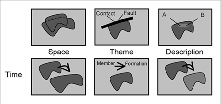
Field observation, as a scientific form of human interpretation, may be described as the interplay of developing scientific and mental models (Brodaric, et. al., 2000; Loudon, 2000). The scientific model consists of how existing scientific theory is applied, while the mental model consists of how personal knowledge and experience is brought to bear (e.g., possibly tacit -- Loudon 2000). Both may possess interpretative elements. For example, data may be limited due to the open nature of the Earth's systems and this may imprecisely constrain the geologic history (i.e., the scientific model), resulting in multiple valid hypotheses from which the best must be selected (Martin, 1998; Schumm, 1991). On the other hand, various human factors such as personal experience and training (i.e., mental models) may also bias observation and subsequent interpretation. The degree to which adjacent map boundaries may differ when mapped by various individuals (e.g., Figure 8, later) attests to the prevalence of one or other interpretative aspect (or both) in the knowledge construction process. The information structuring issues in this devolve to (1) reasoning with insufficient information that leads to multiple valid scientific models, and consequently (2) representing geologic features with various interpretations.
Reasoning from information with gaps is a human strength and a computer weakness. It is reasonable to question the degree to which such human reasoning can be emulated computationally. Nevertheless, pursing the development of human-like inference mechanisms to augment various data processing tasks would seem not only to be fruitful but also necessary for the effective usage of geologic data, and thus for the transcription of human knowledge into digital form. Some efforts to develop such reasoning mechanisms for geology include: (e.g., Flewelling, et. al., 1992; Harrap and Helmstaed, 1998; Simmons, 1983; 1988; Sakamoto, 1994).
The second issue, concerned with representing various interpretations, is a very prominent problem in GIS interoperability (Bishr, 1998) but is one that has received scant attention geoscientifically. Some interrelated key issues include: (1) the nature of geologic feature identity; (2) the depiction of meanings; (3) the depiction of scientific models; and (4) the depiction of three-dimensional geometry and topology, particularly to aid geologic reasoning.
Features are typically portrayed as being simple and having constant and unique identity (e.g. Open GIS Consortium 1999; ISO TC211, 1999; and less so in POSC, 1999). However, the spatial, temporal and descriptive aspects of a geologic feature are often variable, due to scientific disagreement or changes over time and scale; or they are uncertain, due to classification ambiguity (Haugerud, 1998; Figure 7). Geologic information structures must therefore accommodate features that are complex and possess variable and uncertain identity. Moreover, the concepts used to describe established features may themselves conflict and require conceptual clarification or semantic disambiguation; e.g., this situation is often encountered in stratigraphic lexicons where multiple terms may be synonymous, where terms may have multiple meanings or multiple names, or be otherwise related. Enhancing identity and semantics would signify an improvement in geological representation. However, identifying features and explicating their meanings does not constitute a geologic interpretation, for this merely describes what features are and not how they fit together in space and time. Additionally required is a notion of a scientific model as an intentional and particular collection of features, their meanings and geometries, held in concordance with scientific theory -- the geologic map shorthand for this is a legend (and is exploited as such by the North American Geologic Map Data Model (NADM): Raines, et. al., 1997; Johnson, et. al., 1999). In summary, this implies that features, models, theories all need to be digitally represented and their particular spatial, temporal and categorical relations depicted.
|
| Figure 7. Ambiguous geologic feature identity in space, theme and description; due to variable categorization at one time (upper row) and to changes in time (lower row). In the upper row, a geologic feature may be variously interpreted at the same point in time due to diverse opinions regarding the feature�s spatial extents, categorization and description, or due to scale constraints. In the bottom row, a geologic feature�s spatial extents, categorization, or description may change in time due to increased understanding of the feature, or due to physical changes in time arising from geologic processes acting on the feature. |
If these representational issues related to identity, semantics, and models are indeed fundamental, then their impact should extend beyond field information and encompass other forms of geologic interpretation such as regional map synthesis. This is briefly explored next.
Representing and reasoning with geologic information is clearly central to the synthesis task. Yet, how pervasive are the representational issues of identity, semantics, and models, particularly when synthesizing geologic information in order to develop regional geologic interpretations? In the development of regional syntheses multiple sources are integrated into an aggregate entity that is scientifically cohesive. However, spatial scale, spatial resolution, available theory, and data all may contribute to a situation in which the sources may possess varying scientific features, meanings or models (e.g., Figure 8). Correlating and integrating these elements is essential to developing syntheses, and this requires representational and reasoning devices to reconcile between diverse element occurrences (i.e., features, meanings, models) in various source data. Reconciling between diverse scientific models is related to the evaluation of multiple valid models in field interpretation, indicating that the issues found in field information representation and reasoning broadly pervade the synthesis task. This implies that identifying some general and common structuring core for geologic field and synthetic information may be feasible and should be sought. A final concern is the impact of the Internet on geologic information utility, including synthesis. The immediate and obvious conclusion is that the Internet is primarily a communications medium that has minimal intrinsic bearing on the structuring of geologic information. The Internet's hypertext links do permit the construction of a network of documents, but without additional structure this does little to resolve the representation issues related to geologic feature identity, semantics, and models, and, moreover, the Internet provides little inherent reasoning capacity. What the Internet does provide is a substructure onto which such elements could be grafted, and furthermore, due its broad usage, it also provides tremendous incentive and opportunity to do so.
|
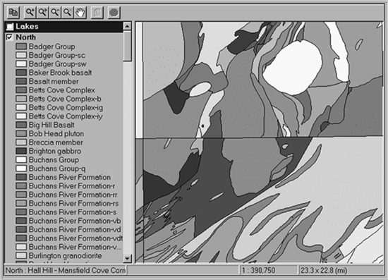
Figure 8. Variable geologic interpretations of the same geographic area, drawn from a digital geologic map database prior to synthesis (from Davenport, et. al., 1999). |
One ramification of increased Internet usage is heightened awareness of information incompatibility, and collaterally, awareness of the need to facilitate the sharing of seemingly incompatible information sources. Apart from the many policy and technical issues attached to data ownership (now being addressed by the e-commerce community -- e.g., http://www.rosettanet.org/), the main obstacle to such information sharing is representational in nature: the ability to represent and interoperate with diverse geospatial concepts is less advanced than our to ability to share diverse spatial database formats or distribute data via the Internet (Bishr, 1998). It is this situation in particular that hinders the on-line synthesis of model-based geologic information (e.g. geologic map information). Though it is reasonable to question the degree to which automated on-line synthesis is possible, it is also reasonable to assume that enhanced structuring of geologic interpretation (including models, features, semantics, and multi-model reasoning) could only aid both automated or expert-driven synthesis, and in this prove altogether beneficial. For example, providing an infrastructure to aid human directed on-line synthesis should facilitate the development of new scientific interpretations (possibly expressed as maps) and thereby contribute to the advancement of some geoscientific knowledge. Moreover, it could also aid in the transformation and transfer of geoscientific information to other knowledge domains, and thus not only meet a prevailing societal imperative but also contribute to the notion of the overall value and utility of geoscientific knowledge.
In essence, the Internet provides ample incentive, opportunity, and a new medium, for geologic information synthesis, but it does not resolve the underlying information structuring issues that pervade synthesis. Indeed, the rapid introduction of various, often competing, Internet developments may act to complicate these issues, as evolving geologic information solutions must cope with relatively fledgling Internet advancements. For example, recent technical developments in the areas of information exchange such as XML (Extensible Markup Language: http://www.w3.org/TR/ and RDF (Resource Description Framework: http://www.w3.org/TR/) provide a means of adding context to documents, thus boosting the information structuring capacity of the Internet, yet two outstanding questions remain in this. Firstly, XML and RDF are not domain specific and require the pre-existence of an appropriate geologic data model; secondly, their suitability in representing such a data model, one that encompasses geologic interpretation, is unknown. Exploration of XML and RDF by the geologic community (e.g., XMML: http://www.ned.dem.csiro.au/XMML/) will contribute to the clarification of these unknowns, particularly when incorporating geologic data models that are map-based and/or inclined to modeling geologic interpretation (e.g., NADM: http://geology.usgs.gov.dm/). This necessary emphasis on information modeling, and its critical position vis a vis technologic development, reinforces the previous suggestion that information modeling not only provides a means of evaluating technology but also possesses the capacity to influence its progress, whether the focus is on field systems or the Internet. In summary, progress in various Internet areas is quickly providing a foundation for information synthesis by facilitating the rapid assembly of diversely located and formatted information in conjunction with an evolving sensitivity to issues of diverse data ownership, proprietary revenue policy, and other information-related practices. What is missing is the know-how and infrastructure to integrate this information geologically, across different themes and geographic areas. This signals an opportunity not only to develop Internet-based geoscientific networks in which data content may be accessed and manipulated, and where proprietary rights are observed, but it also identifies geologic information structuring as a critical task. The scientific and societal benefits of developing such networks for the geosciences could be substantial, and must be exploited by the geoscience community to ensure its viability as both a knowledge generator and a knowledge provider in this 'age of information'.
For these benefits to be realized it is incumbent on the geoscience community to partake in the various ongoing information structuring efforts. But, herein lies the crux of the matter, for traditional geoscience has often neglected the form of its information in favor of its content. The so-called 'information age' can no longer support such neglect, and the various efforts to remedy this by geoscience information providers attests to their acknowledgment of this fact (e.g., CGKN -- Broome, 2000; GEIXS: http://www.eurogeosurveys.org/; NGMDB -- Soller and Berg, 1999). When these efforts evolve from sharing catalogs (i.e., metadata) to sharing and using actual information content -- as required by information synthesis -- then several deep representational and reasoning problems related to geologic feature identity, semantics, geologic models, and reasoning with knowledge gaps will need to be resolved. Their eventual resolution represents a goal and a challenge that must be met for the successful participation of the geosciences in the 'information age'.
Bain, K.A., and Giles, J.R.A., 1997, A standard model for storage of geological map data: Computers and Geosciences, v.23, no.6, p. 613-620.
Bishr, Y., 1998, Overcoming the semantic and other barriers to GIS interoperability: International Journal of Geographical Information Science, v.12, no.4, p.299-314.
Briner, P., Kronenberg, H., Mazurek, M., Horn, H., Engi, M., Peters,T., 1999, FieldBook and GeoDatabase: tools for field data acquisition and analysis: Computers And Geosciences, v.25, no.10, p.1101-1111.
Brodaric, B., 1997, Field Data Capture and manipulation using GSC FieldLog v3.0, in D.R. Soller, ed., Digital Mapping Techniques '97 -- Proceedings of a workshop on digital mapping techniques: methods for geologic map data capture, management and publication: USGS Open File Report 97-269, p.77-82, http://ncgmp.usgs.gov/pubs/of97-269/brodaric.html.
Brodaric, B., and Fyon, J.A., 1990, Continuing Use and Development of Computer-based Field Mapping and Data Storage with OGS FieldLog. Summary of Field Work and Other Activities 1990: Ontario Geological Survey, Misc. Paper 151, p.131-132.
Brodaric, B. and Fyon, J.A., 1989, OGS FieldLog: A Microcomputer-based Method to Store, Process and Display Map-related Data: Ontario Geological Survey Open File Report 5709.
Brodaric, B., and Gahegan, M., 2000, Geoscience Map Data Models, Open Systems GIS and Semantics: Proceedings, GeoCanada2000-The Millenium Geoscience Summit, Calgary, May 29-June 2.
Brodaric, B., Gahegan, M., Takatuska, M. and Harrap, R., 2000, Geocomputing with geological field data: Is there "a ghost in the machine": Proceedings, Geocomputation 2000, Chatham, U.K., August 23-25.
Broome, J., 2000, Developing the Canadian Geoscience Knowledge Network: Proceedings, GeoCanada 2000, May -- June 1, Calgary.
Broome, J., Brodaric, B., Viljoen, D., and Baril, D., 1993, The NATMAP Digital Geoscience Data-Management System: Computers and Geoscience, v.19, no.10, p.1501-1516.
Colman-Sadd, S.P., Ash, J.S., Hayes J.P., and Nolan, L.W., 1996, Management of Geological Map Units in a Geographic Information System. Current Research: Newfoundland Department of Natural Resources, Geological Survey, Report 96-1, p.227-251.
Davenport, P.H., Nolan, L.W., Butler, A.J., Wagenbauer, H.A., and Honarvar, P., 1999, The geoscience atlas of Newfoundland: Geological Survey of Newfoundland, Open File NFLD/2687 (CD-ROM).
Flewelling, D.M., Frank, A.U., and Egonhofer, M.J., 1992, Constructing geological cross sections with a chronology of geologic events, in Proceedings of the 5th International Symposium on Spatial Data Handling: IGU Commission on GIS, August 3-7, 1992, Charleston, S.C., p.544-553.
Harrap, R.M., and Helmstaed, H.,1998, Reasoning across deep time: a formal-reasoning examination of Archean tectonics: Proceedings of the 1998 Annual Meeting of the Geological Society of America.
Haugerud, R., 1998, Geologic Maps, Spatial Databases, and Standards, in D.R. Soller, ed., Digital Mapping Techniques '98 -- Workshop Proceedings: U.S. Geological Survey Open File Report 98-487, p.41-46, https://pubs.usgs.gov/openfile/of98-487/haug1.html.
ISO TC211, 1999, Geographic Information -- Part 2: Overview, 1999-04-10, http://www.statkart.no/isotc211/.
Johnson, B.R., Brodaric, Boyan, Raines, G.L., Hastings, J.T., and Wahl, Ron, 1999, Digital Geologic Map data Model, Version 4.3(a): Unpublished American Association of State Geologists / U.S. Geological Survey draft document, 69 p., http://geology.usgs.gov/dm/model/Model43a.pdf.
Journeay, M., Robinson, J., Talwar, S., Walsh, M., Biggs, D., McNaney, K., Kay, B., Brodaric, B. and Harrap, R., 2000, The Georgia Basin Digital Library: Infrastructure for a Sustainable Future: Proceedings, GeoCanada 2000, May -- June 1, Calgary.
Loudon, T.V., 2000, Geoscience after IT: Part J. Human requirements that shape the evolving geoscience information system: Computers and Geosciences, v.26, no.3A, p.A87-97.
Martin, R.E., 1998, One Long Experiment: Columbia University Press, New York, 262p.
OpenGIS Consortium, 1999, The OpenGIS Abstract Specification, Topic 5: Features, Version 4, http://www.opengis.org/.
POSC, 1999, POSC Specifications -- Epicentre 2.2. Petrotechnical Open Software Corporation, Houston, Texas, http://www.posc.org/.
PPDM, 2000, Public Petroleum Data Model Specifications, 2000-07-21, http://www.ppdm.org/.
Raines, G., Brodaric, B., and Johnson, B., 1997, Digital Geologic Map Data Model, in D.R. Soller, ed., Digital Mapping Techniques '97 -- Proceedings of a workshop on digital mapping techniques: methods for geologic map data capture, management and publication: USGS Open File Report 97-269, p.43-46, http://ncgmp.usgs.gov/pubs/of97-269/raines.html.
Richard, S.M., 1999, Geologic Concept Modeling, with Examples for Lithology and some other Basic Geoscience Features, in D.R. Soller, ed., Digital Mapping Techniques '99 -- Workshop Proceedings: U.S. Geological Survey Open File Report 99-386, p.59-76, https://pubs.usgs.gov/openfile/of99-386/richard.html.
Sakamoto, M., 1994, Mathematical Formulations of Geological Mapping Process -- Algorithms for an Automatic System: Journal of Geosciences, Osaka City University, p.243-292.
Schumm, S.A.,1991, To Interpret the Earth: Ten ways to be wrong: Cambridge University Press, New York, 133p.
Simmons, R.G., 1983, Representing and Reasoning About Change in Geologic Interpretation: Technical Report 749: Massachusetts Institute of Technology, Cambridge, MA.
Simmons, R.G.,1988, Combining associational and causal reasoning to solve interpretation and planning problems: PhD Thesis, Massachusetts Institute of Technology, Cambridge, MA.
Soller, D.R., and Berg, T.M. ,1999, The National Geologic Map Database -- A Progress Report, in D.R. Soller, ed., Digital Mapping Techniques '99 -- Workshop Proceedings: U.S. Geological Survey Open File Report 99-386, p.77-82, https://pubs.usgs.gov/openfile/of99-386/soller1.html.
Home | Contents | Next
U.S.Department of the Interior, U.S. Geological Survey
<https://pubs.usgs.gov/openfile/of00-325/brodaric.html>
Maintained by Dave Soller
Last updated 11.01.00