Title: Interpretation of depositional units of the Mississippi Fan
Publication_Information:
Publication_Place: Woods Hole Field Center
Publisher: U.S. Geological Survey
Description:
Abstract:
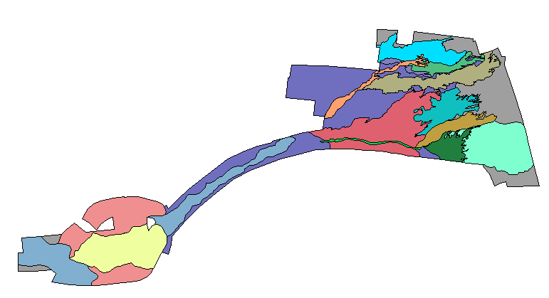
This GIS layer contains an interpretive layer of depositional units at
the edge of the Mississippi Fan.
Purpose:
This GIS overlay is a component of the U. S Geological Survey, Woods Hole
Field Center's, Gulf of Mexico ArcView GIS database. The Gulf of Mexico
GIS database is intended to organize and display USGS held data and provide
on-line (WWW) access to the data and/or metadata.
Time_Period_of_Content:
Time_Period_Information:
Single_Date/Time:
Calendar_Date: 20000228
Currentness_Reference: interpretation date
Status:
Progress: Complete
Maintenance_and_Update_Frequency: None planned
Spatial_Domain:
Bounding_Coordinates:
West_Bounding_Coordinate: -86.5468
East_Bounding_Coordinate: -85.0118
North_Bounding_Coordinate: 26.8299
South_Bounding_Coordinate: 26.1373
Keywords:
Theme:
Theme_Keyword_Thesaurus: General
Theme_Keyword: U.S. Geological Survey
Theme_Keyword: USGS
Theme_Keyword: Woods Hole Field Center
Theme_Keyword: Gulf of Mexico database
Theme_Keyword: ArcView
Theme_Keyword: arcview
Theme_Keyword: shapefile
Theme_Keyword: polygon
Theme_Keyword: Exclusive Economic Zone
Theme_Keyword: EEZ
Theme_Keyword: interpretation
Theme_Keyword: deposits
Theme_Keyword: depositional units
Place:
Place_Keyword_Thesaurus: General
Place_Keyword: Gulf of Mexico
Place_Keyword: Mississippi Fan
Access_Constraints: None
Use_Constraints:
Although this derived data set and it's lineage dataset have been used
by the USGS, no warranty, expressed or implied, is made by the USGS as
to the accuracy of the data and/or related materials. The act of distribution
shall not constitute any such warranty, and no responsibility is assumed
by the USGS in the use of these data or related materials.
The U.S. Geological Survey must be referenced as the originator of the
dataset in any future products or research derived from these data.
The SeaMARC 1A sidescan sonar mosaic was registered and viewed in ArcView.
The interpretation of depositional units was then interactively drawn over
the mosaic to create the ArcView GIS layer.
Process_Step:
Process_Description:
The SeaMARC 1A sidescan sonar mosaic was registered and viewed in ArcView.
The interpretation of depositional units was then interactively drawn over
the mosaic to create the ArcView GIS layer.
Although this derived data set and it's lineage dataset have been used
by the USGS, no warranty, expressed or implied, is made by the USGS as
to the accuracy of the data and/or related materials. The act of distribution
shall not constitute any such warranty, and no responsibility is assumed
by the USGS in the use of these data or related materials.
Standard_Order_Process:
Digital_Form:
Digital_Transfer_Information:
Format_Name: ARCV
Format_Information_Content:
interp.dbf
interp.shp
interp.shx
interp.avl
File_Decompression_Technique: No compression applied
Transfer_Size: 114Kbytes
Digital_Transfer_Option:
Offline_Option:
Offline_Media: CD-ROM
Recording_Capacity:
Recording_Density: 650
Recording_Density_Units: Mbytes
Recording_Format: ISO 9600
Compatibility_Information:
The user must have a system with a CD-ROM capable of reading an ISO-9660
standard CD-ROM disk. To browse the information contained on this disk,
the user must also have a current version of WWW browser available.
Digital_Form:
Digital_Transfer_Information:
Format_Name: ARCV
Format_Information_Content:
The three ArcView shapefiles (interp.dbf, interp.shp, interp.shx) comprising
the interpretation of depositional units of the Mississippi Fan and the
ArcView legend file (interp.avl).
File_Decompression_Technique: zip
Transfer_Size: 79Kbytes
Digital_Transfer_Option:
Offline_Option:
Offline_Media: CD-ROM
Recording_Capacity:
Recording_Density: 650
Recording_Density_Units: Mbytes
Recording_Format: ISO 9600
Compatibility_Information:
The user must have a system with a CD-ROM capable of reading an ISO-9660
standard CD-ROM disk. To browse the information contained on this disk,
the user must also have a current version of WWW browser available. The
user must also have the software installed on their computer system capable
to unzip the archived file.
Fees: none
Technical_Prerequisites:
The deposital unit interpretive overlay is available in an ArcView shapefile
format. The user must have ESRI's ArcView 3.0 or greater software to read
and process the data file. In lieu of Arcview, the user may utilize another
GIS application package capable of importing the data.