 |
| U.S. Deparment of the Interior - U.S. Geological Survey |
 |
U.S. GEOLOGICAL SURVEY OPEN-FILE REPORT 00-358 |
CHAPTER 3: VISUALIZING SEDIMENT DATA LAYERS USING GEOGRAPHIC MAPPING TOOLS |
Polloni, C.F.1, Poppe, L.J.1, Hastings, M.E.1, and Joy, K.2 |
1Coastal and Marine Geology
Program, USGS, Woods Hole, MA 02543 |
INTRODUCTION |
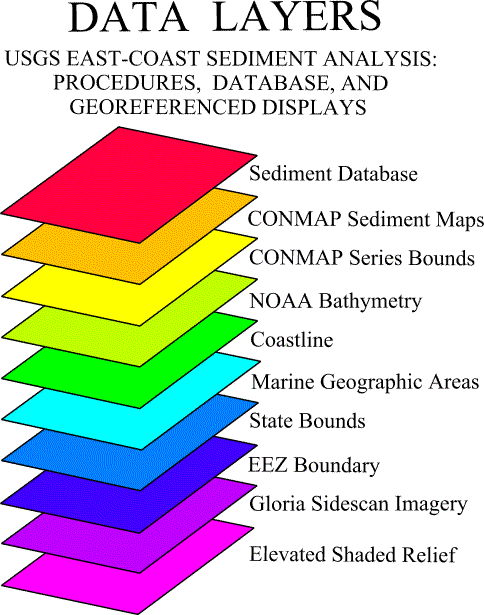
The goals of this chapter include: 1) providing users with the ability to visualize the textural information in a geographic context (Polloni and others, 1995), 2) supplying maps in flexible scales for synthesis (Kenwood and others, 1996; Polloni and others, 1998 ), and 3) giving users the ability to identify and query geographic and attribute data (Polloni, 1998a, b). The primary effort is to deliver the textural data as geo-referenced points so that they can be used on basemaps for other digital data from along the U.S. east coast. Project files are included that already have the inter-disciplinary data layers loaded as theme coverages (Fig. 1). The user can turn data layers on or off, measure distances in user specified units, and add, if available, other user specified themes as long as they are in the same coordinate system (i.e. latitude and longitude in decimal degrees). Coverages in state plane or other coordinate systems must be re-projected to be compatible with these data.
One of the data layers provided here was originally produced for the Continental Margin Mapping Project (CONMAP; Klitgord and Hill, 1986; Escowitz, 1987) of the U.S. Geological Survey (USGS). As part of CONMAP, syntheses of surficial sediment studies on the U.S. Atlantic continental margins were compiled in a series of standardized maps and digital databases to facilitate the transfer and use of the extensive information acquired by the USGS (Poppe and others, 1989; Poppe and others, 1994). The maps, which are intended to be reproduced at a scale of 1:1,000,000, are on an Albers Conic Equal Area Projection with standard parallels at 29.5oN and 45.5oN, and are compatible with the U.S. National Atlas and the USGS geologic and tectonic maps. Although combined for this report, the Atlantic margin was divided into the following four regions for the CONMAP series: Georges Bank Basin and Gulf of Maine, Baltimore Canyon Trough, Carolina Trough, and Blake Plateau Basin. The sediment map from northern-most region was previously released in digital form as part of a marine geographic information system (GIS) library for Massachusetts Bay (Butman and Lindsay, 1999).
Each sediment map in the CONMAP series is a compilation of grain-size data
produced in the sedimentation laboratory of the Woods Hole Field Center of the Coastal and
Marine Geology Program of the USGS and from both published and unpublished studies. These studies are listed in alphabetical order in
the data bibliography (Appendix A). Sediment was classified using the Wentworth (1929) grain-size scale
and the Shepard (1954) scheme of sediment classification. Certain
grain-size categories are combined because of the paucity of some sediment textures;
blank parts of the maps indicate areas where data are insufficient to infer sediment
type. Bathymetry is used as a guide in
placing some of the contacts between different sediment types. However, because the true boundaries between
sediment types are probably highly irregular or gradational, because the extreme textural
variability that characterizes some areas does not appear at this scale, and because the
accuracy of the navigational systems used during the earlier studies is limited, all
contacts should be considered to be inferred. In
summary, the CONMAP series is old and does not accurately depict small-scale sediment
distributions. This data layer is supplied primarily as a gross overview and to show
general textural trends. 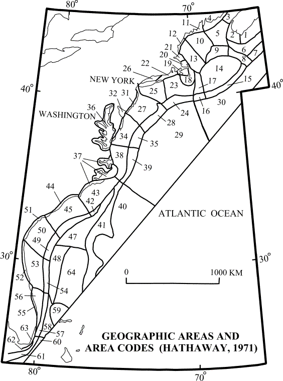
As part of the Continental Margin Program (Emery and Schlee, 1968; Hathaway, 1971), the U.S. east-coast offshore was divided into 64 distinct marine geographic areas. These areas, which are designated by codes and corresponding descriptions (Fig. 2; Appendix B), are also included as a data layer. They are provided to help users visualize the sample locations and sediment distributions in smaller-scale regional contexts.
We have provided the GIS ArcExplorer version 1.1 software so that a user with a Windows 95/98 compatible operating system can down-load it to their own system and use it to display the coverages provided. ArcExplorer can read ArcView shape files included on the CD-ROM and also, if connected to the WWW, can incorporate coverages which may be available on GIS web servers. A manual for ArcExplorer version 1.1 is also provided in Adobe Acrobat (PDF) format. The user must have the Adobe Acrobat software installed to read the ArcExplorer manual. The user is encouraged to get the latest version of the ArcExplorer and Adobe Acrobat software directly from ESRI and Adobe, respectively, on the WWW.
Separate project files are included for both ArcExplorer 1.1 and ArcView 3.1. If you have loaded ArcExplorer 1.1, you can use the project file GEOCST.AEP. This mapping tool will display the data selected in a geographic coordinate system. If you have ArcView version 3.1 or later on a Windows 95/98 system, you should be able to use the EASTCST.APR project file and have the coverages appear on your screen in an Lambert Equal-Area Azimuthal projection and GEOCST.APR to view them in an unprojected geographic display. The images (GLORIA and Elevated Shaded Relief) are both projected only in Lambert Equal-Area Azimuthal and thus are only visible in that projection. For UNIX systems we have provided the EASTCSTU.APR and GEOCSTU.APR project files. All project files are available in the root directory of the CD-ROM. For best results, exit from your browser, activate the mapping tool and open the appropriate project file.
| Filename | Description |
| GEOCST.AEP | ArcExplorer project file (unprojected view) |
| EASTCST.APR | ArcView project file (Lambert Equal-Area Azimuthal projection) |
| GEOCST.APR | ArcView project file (unprojected view) |
| SAGEOCST.APR | ArcView project file, requires ArcView Spatial Analyst (unprojected view) |
| EASTCSTU.APR | ArcView project file that may be accessed in UNIX. Assumes the CD-ROM has been mounted to the directory /cdrom. (Lambert Equal-Area Azimuthal projection) |
| GEOCSTU.APR | ArcView project file that may be accessed in UNIX. Assumes the CD-ROM has been mounted to the directory /cdrom. (unprojected view) |
Although the data assembled on this CD-ROM comes from a variety of sources, we have translated the data layers to be
compatible with the desktop mapping tools ArcExplorer and ArcView from ESRI. The data layers provide texture data and
interpretations for integration and viewing; additional
layers (e.g. coastline, bathymetry, state boundaries) have been included for regional
reference purposes (Fig. 1). All
data has available metadata for source and quality definition. All data with attributes can be queried to display
as much as is available in the individual records.
Data Layers
included on this CD-ROM
Sediment
Texture Database - point data with attributes (Hastings and others, 2000, Chapter 2 this report)
CONMAP
Sediment Maps - USGS CONMAP series, nominal scale 1:1,000,000 (Poppe and others,
1989)
CONMAP
Series Bounds - USGS CONMAP Series
Bathymetry
– NOAA/NOS bathymetry server data (Twichell and Polloni, 1993)
Coastline -
NOAA ec80 series coastline, nominal scale 1:80,000 (NOAA/NOS, 1994)
Marine Geographic Areas - U.S. East
Coast marine region divided into 64 geographic areas (Fig. 2;
Appendix B; Hathaway, 1971)
State Bounds
- USGS 1:100,000 scale national atlas coverage (ESRI sample data)
EEZ boundary
- offshore limit of the U.S. east-coast Exclusive Economic Zone
GLORIA Sidescan Imagery - U.S.
east-coast GLORIA sidescan sonar imagery (Groome and others, 1997)
Elevated Shaded Relief - five-fold
vertically exaggerated shaded relief map of the conterminous U.S. (Groome and
others, 1997)
The following table lists the available datalayers and the associated documentation.
Data Layer |
shape-file or image |
metadata |
source agency |
| Coastlines | ec80*.shp,gc80*.shp | coastlines | NOAA |
| CONMAP Sediment Maps | conmapsg.shp | conmapsm | USGS,WHFC |
| CONMAP Series Bounds | conmapsg.shp | conmapsb | USGS,WHFC |
| Elevated shaded relief | usa_dem.tif | usadem | USGS |
| GLORIA Sidescan imagery | atl_mos.tif | atlmos | USGS,WHFC |
| Marine Geographic Areas | polyarea.shp | polyarea | USGS,WHFC |
| NOAA Bathymetry | bathy.shp | bathy | NOAA,USGS |
| Sediment Database | ecst0500.shp | ecst0500 | USGS,WHFC |
| US EEZ Boundary | useez.shp | useez | US State Department |
A set of project files for ArcExplorer and ArcView are included so that the user
can use them directly. The project files have
links to the data layers provided on the CD-ROM and these links can be switched on and
off. ArcExplorer has been included on this
CD-ROM for off-loading to a users computer system.
Instructions for set-up on the users computer system are included in the ArcExplorer user
manual. To install the ArcExplorer software,
click on the highlighted "ArcExplorer version 1.1" software link. Windows will inform the user that this may
be downloaded or run from its current
location. The application will install if the
user selects the run from current location and follow the instructions for the complete
install. If you have a browser that only has
an option to download (ie NETSCAPE), then the user must download the file (Aeclient.exe,
7Mbyte) and execute the file under their operating system. Aeclient will install
ArcExplorer 1.1 and provide a shortcut for the user to restart the software. Once ArcExplorer is loaded, the user may use the
project file (geocst.aep) to add the primary set of data
themes. Other data themes that are in the
same coordinate system may be added at this time. If
the user has ArcView, the project file (eastcst.apr) can be
used.
We would like to thank Laura Hayes, Tammy Middleton, and Ericka Hammar-Klose for their consultations and able assistance given whenever the moment arose.
Butman, B.,
and Lindsay, J., 1999, A marine GIS library for Massachusetts Bay: focusing on disposal
sites, contaminated sediments, and sea-floor mapping: U.S. Geological Survey Open-File
Report 99-439, CD-ROM.
Emery, K.O. and Schlee, J.S., 1968, The Atlantic continental shelf and slope, a program for study: U.S. Geological Survey Circular 481, 11 p.
Escowitz,
E.C., 1987, U.S. Geological Survey's Continental Margin Mapping Project (CONMAP), U.S.
Geological Survey Open-File Report 87-314, p. 15.
Groome,
M.G., Gutmacher, C.E., and Stevenson, A.J., 1997, Atlas of GLORIA sidescan-sonar imagery
of the Exclusive Economic Zone of the United States:EEZ-View: U.S. Geological Survey
Open-File Report 97-540, CD-ROM.
Klitgord, K.D., and Hill, G.W., 1986, Continental Margin Mapping Project, U.S. Atlantic margin; a synthesis of geologic and geophysical data interpretations: American Association of Petroleum Geologists Bulletin, v. 70, p. 608.
Hathaway, J.C., 1971, Data File - Continental Margin program, Atlantic Coast of the United States: Woods Hole Oceanographic Institution Technical Report, Reference Number 71-15, 491 p.
Polloni,
C.F., Schmuck, E.A., Denny, J.F., Prisloe, M.P., and Babb, I.G., 1995. Marine Geologic Atlases on CD-ROM, A Method of
Assembling, Integrating and
Polloni,
Christopher, Tripp, B., and Truesdale, P., 1998. An
Illustrated
Polloni,
Chris, 1998a, Mapping tools for CDs and the
Web, GRIPS' 98, session chair, in session listing of the SIGCAT'98 CD/DVD Conference and
EXPO,
Polloni,
Chris, 1998b, HTML - XML: An Effective Authoring tool for today's CDs: in Session listing
of the SIGCAT'98 CD/DVD Conference and EXPO, Baltimore, MD,
Poppe, L.J., Schlee, J.S., Butman, B., and Lane, C.M., 1989, Map showing the distribution of surficial sediment, Gulf of Maine and Georges Bank: U.S. Geological Survey Miscellaneous Investigations Series Map I-1986-A, 1 sheet, scale 1:1,000,000.
Poppe, L.J., Schlee, J.S., Knebel, H.J., 1994, Map showing distribution of surficial sediments on the mid-Atlantic continental margin, Cape Cod to Albemarle Sound: U.S. Geological Survey Miscellaneous investigations Series Map I-1987-D, 1 sheet, scale 1:1,000,000.
Shepard, F.P., 1954, Nomenclature based on sand-silt-clay ratios: Journal Sedimentary Petrology, v.24, p. 151-158.
Schruben, P., 1999, Color shaded relief map of the conterminous United States: U.S. Geological Survey Open-File Report 99-11, https://pubs.usgs.gov/openfile/of99-011/.
Twichell, D.C. and Polloni, C.F., 1993, CD-ROM Atlas of the Deepwater Parts of the U.S. Exclusive Economic Zone in the Atlantic Ocean, the Gulf of Mexico, and the Eastern Caribbean Sea: U.S. Geological Survey Digital Data Series DDS-15 CD-ROM.
Wentworth, C.K., 1929, A scale of grade and class terms for clastic sediments: Journal Sedimentary Petrology, v. 30, p. 377-392.
Figure 1. Graphic shows the integration of georeferenced
displays included on this CD-ROM. Individual
data layers can be turned on or off and rearranged.
Figure 2. Index map showing the locations of the area codes.
Descriptions of the area codes are given in Appendix B.
APPENDIX A. DATA BIBLIOGRAPHY
The following references were used to construct the U.S. east-coast surficial
sediment maps in the CONMAP series and respective data layer. Each supplied basic data and
control-point locations or interpretations.
Ayers, M.W.,
and Pilkey, 1980, Piston core and surficial sediment investigations of the
Florida-Hatteras slope and inner Blake Plateau, In: P. Popenoe (ed.) Environmental
Geologic Studies on the Southeastern Atlantic Outer Continental Shelf 1977-1978, U.S.
Geological Survey Open-File Report 81-582, Chapter 5, 89 p.
Batten,
R.W., 1962, The sediments of the Beauford Inlet area, North Carolina: Southeastern
Geology, v. 3, p. 191-206.
Bennett,
R.H., Freeland, G.L., Lambert, D.N., Sawyer, W.B., and Keller, G.H., 1980, Geotechnical
properties of surficial sediments in a megacorridor--U.S. Atlantic Slope, Rise, and
deep-sea basin: Marine Geology, v. 38, no. 1, p. 123-140.
Bothner,
M.H., 1977, Texture and clay mineralogy in hydrostatically-damped gravity cores, in Folger
D.W., ed., Middle Atlantic Outer Continental Shelf Environmental Studies: Report to the
Bureau of Land Management, No. 08550-MU5-33, 6 p.
Bothner,
M.H., Aruscavage, P.J., Ferrebee, W.M., and Baedecker, P.A., 1980, Trace metal
concentrations in sediment cores from the continental shelf off the southeastern United
States: Estuarine and Coastal Marine Science, v. 10, p. 523-541.
Bothner,
M.H., Rendigs, R.R., Campbell, E., Doughten, M.W., Aruscavage, P.J., Dorrzapf, A.F.,
Johnson, R.G., Parmenter, C.M., Pickering, M.J., Brewster, D.C., and Brown, F.W., 1984,
The Georges Bank monitoring program 1983; analysis of trace metals in bottom sediments:
U.S. Geological Survey Circular 915, 36 p.
Byrne, R.J.,
Hobbs, C.H., and Carron, M.J., 1982, Baseline sediment studies to determine distribution,
physical properties, sedimentation budgets and rates in the Virginia portion of the
Chesapeake Bay: Final Report to the U.S. Environmental Protection Agency, R806001010, 155
p.
Coch, N.K.,
1986, Sediment characteristics and facies distributions, in Coch N.K. and Bokuniewicz
H.J., eds., Sedimentation in the Hudson System: The Hudson River and Contigenous
Waterways: Northeastern Geology, Special Issue, v. 8, no. 3, p. 109-129.
Cohee, G.V.,
1937, Ocean bottom sediments off the mid-Atlantic coast: Unpublished PhD dissertation,
Champaign-Urbana, IL, University of Illinois, 250 p.
Cornell
University, 1953, Final Report, New York Harbor: US Navy Hydrographic Office, Contract N6
no. 084-033, v. 4A-F.
DeFalco, P.,
1967, Geology of Raritan Bay: U.S. Federal Water Pollution Control Administration
Conference on pollution of Raritan Bay and adjacent interstate waters, Third Session, New
York 1967, Proc., v. 2, p. 760-815.
Doyle, L.J.,
Wall, F.M., and Schroeder, P., 1980, Sediments and sedimentary processes as interpreted
from piston cores and grab samples from the continental slope of the southeastern United
States, In: P. Popenoe (ed.) Environmental Geologic Studies on the Southeastern Atlantic
Outer Continental Shelf, 1977-1978, U.S. geological Survey Open-File Report 81-582,
Chapter 4, 45 p.
Duane, D.B.,
1968, Sand deposits on the continental shelf and slope - a presently exploitable resource:
National Symposium Ocean Science and engineering Atlantic Shelf transcripts, Philadelphia,
PA, p. 289-297.
Emery, K.O.,
1968, Relict sediments on continental shelves of world: American Association of Petroleum
Geologists, v. 52, p. 445-464.
Ferrebee,
W.M., and McElroy, D.K., 1981, Samples from the eastern continental margin collected by
the U.S. geological Survey: U.S. Geological Survey Open-File Report 81-467, 3 p.
Field, M.E,
and Pilkey, O.H., 1971, Deposition of deep-sea sands: comparison of two areas of the
Carolina continental rise: Journal of Sedimentary Petrology, v. 41, p. 526-536.
Folger,
D.W., 1972, Characteristics of estuarine sediments of the United States: U.S. Geological
Survey Professional Paper 742, 94 p.
Folger,
D.W., O’Hara, C.J., Robb, J.M., 1975, Maps showing bottom sediments on the
continental shelf off the northeastern United States - Cape Ann, Massachusetts to Casco
Bay, Maine: U.S. Geological Survey Miscellaneous Investigations Series Map I-839, scales
1:125,000 and 1:250,000.
Frank, W.M.,
and Friedman, G.M., 1973, Continental shelf sediments off New Jersey: Journal of
Sedimentary Petrology, v. 43, no. 1, p. 224-237.
Freeland,
G.L., Stanley, D.J., Swift, D.J.P., and Lambert, D.N., 1981, The Hudson shelf valley --Its
role in shelf sediment transport: Marine Geology, v. 42, p. 399-427.
Fritz, S.J.,
and Pilkey, O.H., 1975, Distinguishing bottom and turbidity current coarse layers on the
continental rise: Journal sedimentary Petrology, v. 45, p. 57-62.
Garrison,
L.E., and McMaster, R.L., 1966, Sediments and geomorphology of the sediments off southern
New England: Marine Geology, v. 4, p. 273-289.
Ginsburg,
R.N., 1956, Environmental relationships of grain size and constituent particles in some
south Florida carbonate sediments: Bulletin American Association of Petroleum Geologists,
v. 40, p. 2384-2427.
Goodell,
H.G., 1967, The sediments and sedimentary geochemistry of the southeastern shelf: Journal
Geology, v. 75, p. 665-692.
Gorsline,
D.S., 1963, Bottom sediments of the Atlantic shelf and slope off the southeastern Unite
d States:
Journal Geology, v. 71, p. 422-440.
Hathaway,
J.C., 1971, Data File - Continental Margin program, Atlantic Coast of the United States:
Woods Hole Oceanographic Institution Technical Report, Reference Number 71-15, 491 p.
Hollister,
C.D., 1973, Atlantic continental shelf and slope of the United States - texture of surface
sediments from New Jersey to southern Florida: U.S. Geological Survey Professional Paper
529-M, 23 p.
Johnson,
F.K., 1959, The sediments of Newport River estuary, Moorehead City, North Carolina:
University of North carolina, unpublished Masters Thesis, 36 p.
Jones, C.R.,
and Schubel, J.R., 1980, Distributions of surficial sediment and eelgrass in Great South
Bay, New York--from Smith Point, West to Wantagh State Parkway: State University of New
York at Stoney Brook Marine Sciences Research Center Special Report 39, Reference 80-6, 19
p.
Kerhin,
R.T., Halka, J.P., Wells, D.V., Hennessee, E. L., Blakeslee, P.J., Zoltan, N., and
Cuthbertson, R.H., 1988, The sediments of Chesapeake Bay, Maryland: Physical
Characteristics and sediment budget: Maryland Geological Survey Report of Investigations
No. 48, 82 p.
Klasik,
J.A., and Pilkey, O.H., 1975, Processes of sedimentation on the Atlantic continental rise
off the southeastern U.S., Marine Geology, v. 19, p. 69-89.
Knebel,
H.J., 1981, Processes controlling the characteristics of the surficial sand sheet, U.S.
Atlantic outer continental shelf: Marine Geology, v. 42, p. 349-368.
Maciolek,
N., Grassle, J.F., Hecker, B., Boehm, P.D., Brown, B., Dade, B., Steinhauer, W.G.,
Baptiste, E., Ruff, R.E, Petrecca, R., 1986, Study of biological processes on the
mid-Atlantic slope and rise: Final Report to the Department of the Interior, Minerals
Management Service, MMS 86-0004, 314 p.
Maciolek,
N., Hecker, B., Butman, C.A., Grassle, J.F., Dade, W.B., Boehm, P.D., Steinhauer, W.G.,
Starczk, V., Baptiste, E., Ruff, R.E., and Brown, B., 1986, Study of the biological
processes on the North Atlantic Slope and Rise: Final Report to the Department of the
Interior, Minerals Management Service, MMS 86-0022, 201 p.
Martens,
J.H.C., 1935, Beach sands between Charleston, South Carolina, and Miami, Florida: Bulletin
Geological Society America, v. 46, p. 1563-1596.
McKinney,
T.F., and Friedman, G.M., 1970, Continental shelf sediments of Long Island, New York:
Journal of Sedimentary Petrology, v. 40, no. 1, p. 213-248.
McMaster,
R.L., 1960, Sediments of Narragansett Bay system and Rhode Island Sound, Rhode Island:
Journal of Sedimentary Petrology, v. 30, no. 2, p. 249-274.
Milligan,
D.B., 1962, Marine geology of the Florida Straits: Unpublished Masters Thesis, Florida
State University, 120 p.
Milliman,
J.D., Pilkey, O.H., and Blackwater, B.W., 1968, Carbonate sediments on the continental
shelf, Cape Hatteras to Cape Romain: Southeastern Geology, v. 9, p. 245-267.
Moore, J.R.,
1963, Bottom sediment studies, Buzzards Bay, Massachusetts: Journal of Sedimentary
Petrology, v. 33, no. 3, p. 511-558.
Nichols,
M.M., 1964, Characteristics of sedimentary environments in Moriches Bay, in Miller, R.L.,
ed., Papers in Marine Geology- Shepard Commemorative Volume: New York, Macmillan Co., p.
363-383.
Pels, R.J.,
1967, Sediments of Albemarle Sound, North Carolina: Unpublished Masters Thesis, University
of North Carolina at Chapel Hill, 73 p.
Pickett,
T.E., and Ingram, R.L., 1969, The modern sediments of Pamlico Sound, North Carolina:
Southeastern Geology, v. 11, p. 53-83.
Pilkey,
O.H., 1964, The size distribution and mineralogy of the carbonate fraction of the United
States south Atlantic shelf and upper slope sediments: Marine Geology, v. 2, p. 121-136.
Pilkey,
O.H., and Frankenberg, D., 1964, The
relict-Recent sediment boundary on the Georgia continental shelf: Georgia Academy Science
Bulletin, v. 22, p. 37-40.
Pilkey,
O.H., Blackwelder, B.W., Doyle, L.J., Estes, E., and Terlecky, P.M., 1969, Aspects of
carbonate sedimentation on the Atlantic Continental Shelf off the southern United States:
Journal Sedimentary Petrology, v. 39, p. 744-768.
Pilkey,
O.H., Keer, F., and Keer, S., 1980, Surficial sediments of the U.S. Atlantic southeastern United States continental shelf, in
Popenoe, P., ed., Environmental Studies -- Southeastern United States Atlantic Outer
Continental Shelf; U.S. Geological Survey Open-File Report 80-146, 40 p.
Reid, R.N.,
1982, Sediment granulometry, organic carbon, and nitrogen, in Reid, R.N., O'Reilly, J.E.
and Zdanowicz, V.S., eds., Contaminants in New York Bight and Long Island Sound Sediments
and Demersal Species and Contaminant Effects on Benthos, Summer 1980: NOAA Technical
Memorandum NMFS-F/NEC-16, p. 7-13.
Rowe, G.T.,
and Clifford, C.H., 1978, Sediment data from short cores taken in the northwest Atlantic
Ocean: Woods Hole Oceanographic Institution Technical Report 78-46, 56 p.
Schlee,
J.S., 1973, Atlantic continental shelf and slope of the United States - sediment texture
of the northeastern part: U.S. Geological Survey Professional Paper 529-L, 64 p.
Schlee,
J.S., Folger, D.W., and O'Hara, C.J., 1973, Bottom sediments of the continental shelf off
the northeastern United States--Cape Cod to Cape Ann, Massachusetts: U.S. Geological
Survey Miscellaneous Investigations Series Map I-746.
Shepard,
F.P., 1932, Sediments of continental shelves: Bulletin Geological Society America, v. 43,
p. 1017-1040.
Stanley,
D.J., and Wear, C.M., 1978, The "Mud-line"--an erosion-deposition boundary on
the upper continental slope: Marine Geology, v. 28, p. M19-M29.
Stetson,
H.C., 1938, The sediments of the continental shelf off the eastern United States: papers
in Physical Oceanography and Meteorology, Massachusetts Institute of Technology, v. 5, p.
1-46.
Stow,
D.A.V., 1976, Deep water sands and silts on the Nova Scotian continental margin:: Maritime
Sediments, v. 12, p. 81-90.
Swift ,
D.J.P., Pelletier, B.R., Lyall, A.K., and Miller, J.A., 1969, Sediments of the Bay of
Fundy - a preliminary report: Maritime Sediments, v. 5, p. 95-100.
Tucholke,
B.E., 1984, Marine Geology, In: Marine Geoscience Applications Inc. (Eds.), Environmental
Summary of the U.S. Atlantic Continental Slope and Rise, 28-42oN, Chap. 4, 183
p.
Tyler, S.A.,
1934, A study of sediments from North Carolina and Florida coasts: Journal Sedimentary
Petrology, v. 4, p. 3-11.
Twichell,
D.C., McClennen, C.E., and Butman, B., 1981, Morphology and processes associated with the
accumulation of the fine-grained sediment deposit on the southern New England shelf:
Journal Sedimentary Petrology, v. 51, p. 269-280.
Uchupi, E.,
1963, Sediments on the continental margin off eastern United States: U.S. Geological
Survey Professional Paper 475-C, p. C132-C137.
Valentine,
P.C., Cooper, R.A., and Uzmann, J.R., 1984, Submarine sand dunes and sedimentary
environments in Oceanographer Canyon: Journal Sedimentary Petrology, v. 54, p. 704-715.
Weil, C.B.,
1976, A model for the distribution, dynamics, and evolution of Holocene sediments and
morphologic features of Delaware Bay: University of Delaware, unpublished Ph.D.
dissertation, 311 p.
Wigley,
R.L., 1961, Bottom sediments of Georges Bank: Journal of Sedimentary Petrology, v. 31, no.
2, p. 165-188.
APPENDIX B.
U.S. EAST COAST MARINE GEOGRAPHIC AREAS
List of the 64 geographic areas into which Hathaway (1971) assigned the offshore
U.S. East Coast Marine Geographic areas and their corresponding numeric area codes.
Area Code Geographic Area
1
Scotian Shelf
2
South of Nova Scotia
3
Bay of Fundy
4
Northern Maine Coast
5
Northern Gulf of Maine
6
Browns Bank
7
Continental Slope South of Nova Scotia
8
Northeast Channel
9
Georges Basin Area
10
Central Gulf of Maine
11
Central Maine Coast
12
Northern Massachusetts and New Hampshire Coast
13
Southern Gulf of Maine
14
Georges Bank
15
Continental Slope South of Georges Bank
16
Continental Slope South of Great South Channel
17
Great South Channel
18
Nantucket Shoals
19
Nantucket and Vineyard Sounds and Buzzards Bay
20
Cape Cod Bay
21
Massachusetts Bay
22
Narragansett Bay and Block Island Sound
23
Shelf South of New England
24
Slope South of New England
25
Shelf South of Long Island
26
Long Island Sound
27
Shelf East of New Jersey
28
Slope East of New Jersey
29
Middle Atlantic Continental Rise
30
New England Continental Rise
31
New Jersey Coast
32
Delaware Bay
33
Delaware Coast
34
Shelf East of Delaware
35
Slope East of Delaware
36
Chesapeake Bay
37
Albemarle and Pamlico Sounds
38
Shelf East of Virginia and North Carolina
39
Slope East of Virginia and North Carolina
40
Southern Continental Rise
41
Blake Escarpment, Ridge, and Spur
42
Florida-Hatteras Slope off North Carolina
43
Shelf off North Carolina
44
South Carolina Coast
45
Shelf off South Carolina
46
Florida-Hatteras Slope off South Carolina
47
Northern Blake Plateau
48
Inner Blake Plateau
49
Florida Hatteras Slope off Georgia
50
Shelf off Georia
51
Georgia Coast
52
Northern Florida Coast
53
Northern Florida Shelf
54
Florida-Hatteras Slope off Northern Florida
55
Central Florida Coast
56
Central Florida Shelf
57
Florida-Hatteras Slope off entral Florida
58
Northern Straits of Florida
59
Bahama Banks
60
Southern Straits of Florida
61
Southern Florida-Hatteras Slope
62
Shelf off Florida Keys
63
Florida Bay
64
Outer Blake Plateau
Return to
Database Section
Continue to Contacts
Return to the Table of Contents